November 2017

November 2017 in the books…

One very alarming, at the same time sad thing stands out. The poor Oakland MMTS siting is absolutely ruining the numbers, which affects the long term running mean and all the work of the past 100+years of data collecting. Its a crying shame to see. Its very obvious.

Overall November 2017 will go down as a slightly below normal temperature month, but also a very dry month. Due to the very dry air, remnants of Nov 19th snow remained in spots until today. Which was only a 2-4″ snowfall, and thats quite incredible given the temps the past 10 days. Low dew points, low sun angle, short days, allowed north facing slopes, shaded areas to retain very light patches. Talking very minimal, but existent in spots. Thats reflected in my daily post.


November 30.         min.       max.     avg

Bitt 2NW valley     26.2         57.4      41.8

Garrett College     28.9         58.7      43.8

Can-Heights         36.9         55          46.0

CRN-Canaan        35.3        56.3       45.8

Cabin Mt              33.8.       52.5       43.2

Cabin Mt north  35.1          52.3        43.7

Snowshoe/S.C    36        49.8          42.9

Can-Valley Floor 23.8     58.4        41.1

Cresaptown       33.1       57.8         45.4

Green Bank Obs 26.8     58.5         42.7

7Springs             36.8       59.7        48.2

Clouds gave way to sunshine, frosty in some valleys. Had frost at Bitt 2NW valley. Clouds moved back in later in the afternoon and gave way to rain after dark. There was spotty showers prior to dark.

A reported 4.4(may be adjusted to 4.1) earthquake in Deleware. Felt from Baltimore to NYC.

November 29.          min.        max.      avg

Bitt 2NW valley      23.7          51.6     37.6

Garrett College      27.8          52.7      40.2

Can-Heights           29.9           50.6    40.2

CRN-Canaan          29.7          51.4     40.6

Cabin Mt                34.9          47.8     41.3

Cabin Mt north    36.9          46.8      41.8

Snowshoe/S.C       38.8          47.5     43

Can-Valley Floor  21.3         53.0     37.1

Cresaptown          30.2         65.5     47.5

Green Bank Obs  22.4         60.9     41.7

7Springs               37.3          52.9    45.1

Temps rose in high valleys overnight, deeper valleys held colder, high ground remained up, but held steady during the day.  East of the mts temps were much warmer today.

These patches of leftover snow from 11 days ago illustrate just how very dry the air mass has been. Despite temps reaching the 50s on multiple occasions.

Today, some morning cloudiness gave way to more sunshine.

Screenshot_20171129-202430

November 28.       min.         max.        avg

Bitt 2NW valley    24.7       59.8        42.2

Garrett College     30.2       62.3        46.2

Can-Heights         35.7       56.5         46.1

CRN-Canaan       35.0        58.1        46.5

Cabin Mt             37.8       55.6         46.7

Cabin Mt north 37.9       53.6*       45.4

Snowshoe/S.C    38.7      50.7         44.7

Can-Valley Floor 16.4    60.6      38.5

Cresaptown     28.8       63.2        46

Green Bank Obs 20.7   58.3        39.5

7Springs        38.7          62          50.3

Large inversions to start the day. Very mild, but very dry air. Minimal snow melt at the resorts. Sunny, light breezes.

To note, big temp variations after dark from valleys to high ground.

*Cabin Mt North had some technical issues and was down for a spell today. Not positive max was recorded accurately.

gefs_t850anom_16_noram_1
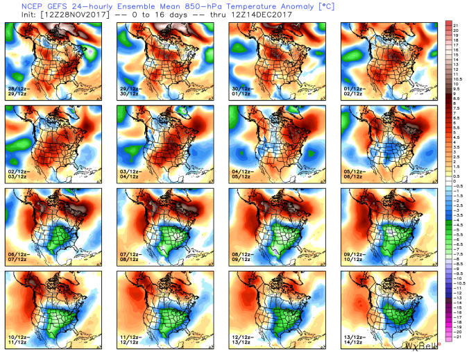
Long range, Gfs as well as other models showing the flip to colder weather coming after week 1 in December.


November 27.       min.         max.        avg

Bitt 2NW valley   27.6        47.7       37.6

Garrett College   32.3         49          40.7

Can-Heights        27.7        43.6        35.7

CRN-Canaan      28.9        46.6        37.7

Cabin Mt           24.4         43.2       33.8

Cabin Mt north 26.4      42.1       34.2

Snowshoe/S.C  26.1       40.8       33.3

Can-Valley Floor  21.1   48.9      35

Cresaptown  34.2         62.8         48.2

Green Bank Obs 21.7   53.6        37.7

7Springs       34.3         48.4         41.3

Almost wall to wall sunny day. Breezy at times. Very dry air mass. Only posting some of the pics with dabs of snow to illustrate how little temps above freezing with the very dry air melt it in shady locations.


November 26.        min.          max.      avg

Bitt 2NW valley    30.8         40.1       35.4

Garrett College    31.7          39.3      35.5

Can-Heights         26.9         35.3       31.1

CRN-Canaan       28.3          37.4       32.8

Cabin Mt            24.3           34          29.1

Cabin Mt north 25.3         33.6        29.4

Snowshoe/S.C   24.1         33.6        28.8

Can-Valley Floor 29.4   40.6          35

Cresaptown     38           52.7           45.2

Green Bank Obs 24       47.6          35.8

7Springs        31.8          40.7          36.2

Cloudy start, isolated fine flake. Cold wind….skies clearing during the morning hours and remaining so the remainder of the day.

Snowshoe only resort making snow early and after dark. (posted 6:31pm) Maybe more will join in

Still a few spotty patches of snow from last Sunday remain(undrifted) and some mini drifts as well…dry air has been the rule.

Long range still looks like winter around Dec 10 +/-

November 25.     min.         max.          avg

Bitt 2NW valley  25.2         51.5          38.3

Garrett College   31.4         51.6         41.5

Can-Heights       35.1          46.2        40.7

CRN-Canaan      36.9          48.8        42.8

Cabin Mt           32             45.7         38.8

Cabin Mt north 33.1        45.5         39.3

Snowshoe/S.C  32.2         43.5         37.8

Can-Valley Floor 24.5    50.8       37.6

Cresaptown      27          62.1        44.5

Green Bank Obs 19.8    54.5       37.2

7Springs         40.8          53.2      46.9

Day began very breezy, with deep valles retaining cold air past dawn. Times of clouds and some sun today. Breezes stayed up through the day.

Last example of dry air and limited snow melting power. A few spots held a little snow until evening, despite 50°+ for the 3rd time this week. This on a less than 2″ depth from last Sunday.  Man made snow at the resorts had next to no impacts for snow loss.

First day of Md rifle season.

Winter Thoughts

Thoughts about this upcoming winter. Through the fall, there simply was no overwhelming signal to point a direction for the winter. Currently, nothing overwhelming in my eyes, but hints and LOTS of differences from last year.

Differences are:

1- a more east based La Nina. Southeast ridge is further south.

2- a east Qbo, enhances a negative AO.

3- cooler waters off the southeast coast vs last year. The stubborn southeast ridge that continued feeding back off the very warm waters last year, will not be a reoccurring theme.

4- 30-40N on the dateline a hint of the cold pool that was there, faded and now returning and some warmer waters forming off the PNW coast. (that may been more than 1 thing) Enhances a +pna(western ridge)

5- A significant coverage increase in North America snowpack. Especially over Canada. While this can vary at any point, the locations currently covered, looked locked in. This can enhance cold air available when it comes.

6- MJO- short term,  as this is not a long term prediction. Its been in the poor phases despite other signals being well aligned for cold to date. A zonal fast flow, has not allowed anything to dig and form and really entrench the cold. Things are zipping along, including moisture.

Screenshot_20171124-191519

Snow cover extent- Snow cover is on the high side vs the past 13 years across North America and especially Canada. While encroachment into the U.S had been slowed by a zonal flow, its available when things get more favorably aligned. Which may be sooner than later. Screenshot_20171124-185831

Current SST setup and 7 day sst change. While this is a constant flux, the trend has been going this way for weeks. Last winter I spent many many hours looking at SST reanalysis. Mainly during the very warm February. It matched 1932(an incredibly warm Feb and one that beat last Feb) well, and the 1932 transition from Feb to March transitioned almost in the same locations as this past year. That test was a success as models went to those analogs. This year, while I have not had time to draw up comparisons like I would like. The overall setup is a look of a more favorable east cold.

What I mean by that. 30-40N just east at the dateline a cool pool has been developing, with a increase in SST temps east of this. This should create more of a -wpo, and -epo. Ridging is more persistent along the west. The Southeast ridge, while is typical in La Ninas and a triple whammy last year with very warm waters off the southeast coast, a west based La Nina, and a westerly Qbo. All 3 are shown to favor a southeast ridge off the southeast coast. This in turn promotes a more consistent southwest warm flow and deflects cold pushes off to the north. Any intruding cold gets followed by a warm push.

Subtle differences in La Ninas with a easterly/neg qbo vs westerly. The Southeast ridge is much further south. Joe D’Aleo mentions this work often and plenty of examples.

The easterly qbo also enhances a negative Artic Oscillation which allows polar air to migrate from the polar regions and spread south. Low solar, which we are in now(not pictured) as well enhances a negative AO.  During winter, Sudden Stratospheric Warming (SSW)events are more typical with low solar . When the stratosphere warm and propagates downward, enhances a cold push to lower levels and depending upon where this occurs, can cause major cold intrusions into the U.S. So, with the large N.A snowcover, should this pan out, we may have some extreme outbreaks in the heart of winter.

Our current MJO is in a unfavorable phase the next 2 weeks off the models. With hints of going into more favorable winter phases. This I believe occurs in the 10th-14th timeframe.

The current state of the teleconnections have not been bad. One thing to watch for, with the SST anomalies warming off the west coast is for the PNA to pop positive 2nd week of December. That will equal ridging west. By then with Mjo becoming more favorable, teleconnections in favorable cold positions, a trough east. This along with the other before mentioned keys, will equate to a cold 2nd half of December and going into the new year.

For anyone thinking its like last year. Nothing like it in the overall results. Also nothing like it in the hidden aspects we can’t see. This should equate to a winter, not like the last 2.

The Euro weeklies have shown consistent cold coming in December. The CFS is off the charts and changes dramatically at times. Hesitant to use it except when in line with other factors. The Euro weeklies are lining up with what the SST anomalies currently are looking like they are going to.

Conclusion on my thoughts-

A different winter than the past 2. A more consistent cold pattern with a east based qbo, east based la nina, a Pacific sst pattern resembling a winter with some good eastern cold. SST temps off southeast resembling that more as well. While at times things will bounce,with incoming troughs exiting on sw winds and warm ups. I expect those warmups to be just typical of what this area sees in the winter. Followed by colder periods.  Storms can and will at times cut west. Leaving us on the wintry mix, to rain, back to snow. As that occurs, thats when the coldest air masses may intrude in behind those systems with lake affect and upslope events.

Overall- A slightly below normal temp winter. With potential of several extreme cold outbreaks.

Snowfall wise- Average to slightly above.


November 24.          min.       max.      avg

Bitt 2NW valley       20.1       51.3     35.7

Garrett College       27.9        54.9    41.4

Can-Heights          25.4         51.2     38.3

CRN-Canaan       26.4          53.7      40.0

Cabin Mt           27.9            50        39

Cabin Mt north  28.6        50.9      39.8

Snowshoe/S.C.  30.9         50.2      40.5

Can-Valley Floor 14.4     55.6      35

Cresaptown       22.5        58.5      40.3

Green Bank Obs  16.8     57         36.9

7Springs          27.6          52.4      40

Clear, calm, fairly large inversions this morning. Very dry air. Loy humidity, dew points. With multiple 50°+ days this week, shaded areas , north facing areas, still areas with very light snowcover from the minimal amount that fell last Sunday. Lasted through today.

Goes to show, sometimes resorts see a temp forecast and fail to pull the trigger on snowmaking thinking it will melt instead of focusing on the type of air mass.

7Springs and Snowshoe opened today.

Thanksgiving

Nov 23.          min.       max.          avg

Bitt 2NW valley 19.7     36.4       28.0

Garrett College   20.4    39.8       30.1

Can-Heights       17.9     35.4       26.6

CRN-Canaan      19.0     38.3       28.7

Cabin Mt           15.1      35.4       25.2

Cabin Mt north 16.7     34.9       25.8

Snowshoe/S.C    19          36.3     27.6

Can-Valley Floor  10.3       41.6    25.9

Cresaptown   19.8         46.1        32.6

Green Bank Obs 13       49.5        31.2

7Springs        21.3          36.2        28.7

Overall a cold, sunny day. Snowshoe maximizing the very dry air for snowmaking even with temps above other resorts.