November 22.          min.        max      avg

Bitt 2NW valley       24.7         39.4     32.0

Garrett College      24.6           44.1     34.3

Can-Heights          20.2            43.7     32

CRN-Canaan        22.4            45.1      33.7

Cabin Mt             17.6            41.9      29.8

Cabin Mt north  18.3           42.1      30.2

Snowshoe/S.C     19.2          43.2      31.1

Can-Valley Floor 21.9        45.2     33.5

Cresaptown       31.8          46.2      39

Green Bank Obs 23.2        41.8      32.5

7Springs             25.4         47.6      36.5

Cloudy, falling temps. Light drizzle to patchy light fine snow that looked to remain mainly in northern Alleghenies. Windy day.  Very cold feel to the air.


Bitt 2NW valley snow accumulation .1″

Bitt 2NW valley at 6.0″ on the season

Slightly higher amount nearing .5″ today in spots


November 21.     min.       max.     avg

Bitt 2NW valley  22.9       51.3       37.1

Garrett College  33.4        53.9      43.7

Can-Heights       30.1        49.2      39.5

CRN-Canaan      30.5        51.1      40.8

Cabin Mt.          34.3        46.2       40.2

Cabin Mt north 33.4      48           40.5

Snowshoe/S.C   33.8       46.2         40

Can-Valley Floor 17.9    52.8       35.3

Cresaptown     20.7        62.6        41.7

Green Bank Obs 14.3    55           34.7

7Springs          31.7         53          42.3

Large temp variation to begin the day, teens, 20s, 30s,  to near 40 high ground. Very dry air,,enough so that Snowshoe was making snow at 35°+… Shady, north facing slopes held slim snow cover through the day despite temps upper 40s,,low 50s. . Temps fell off fast in some valleys at sunset(20s), high ground remained mild through midnight.


November 20.        min.        max.       avg

Bitt 2NW valley  21.5            36.4       28.9

Garrett College  22.1            39.1       30.6

Can-Heights       18.1               34       26

CRN-Canaan      20.0             37.8      28.9

Cabin Mt         15.4               34         24.7

Cabin Mt north 16.5           34.3     25.4

Snowshoe/S.C  16.9             34.7     25.7

Can-Valley Floor 19.7        39.9      29.8

Cresaptown.      25.9              48.2       37

Green Bank Obs 21.8           45.2        33.5

7Springs             24               39.4        31.7

Skies cleared early and winds died down. Roads were very slick and ice covered spots and remained so through the day in shady spots.


Total snowfall amounts with the event from Saturday night

Canaan Valley 3″

Canaan Heights 2.7″

Bayard 2.3″

Terra Alta 4″ with only a 1″ depth. Questionable tally

Bitt 2NW valley 2.2″


Screenshot_20171119-184912


November 19.        min.        max.    avg

Bitt 2NW valley  26.9         52.3(mn) 39.6

Garrett College   27           54            40.5

Can-Heights       22.4        48.5          35.5

CRN-Canaan      24.6        50.0          37.3

Cabin Mt            19.4        45.7        32.5

Cabin Mt north 20.8       46.9          33.8

Snowshoe/S.C   19.6        45.9         32.8

Can-Valley Floor 25.1   50.0        37.5

Cresaptown     33.8         47.1        39.4

Green Bank Obs 28.6      51.5       40

7Springs           27            56.8       41.8

Rain to snow around 2-3am. Daytime maxes were midnight highs. As mentioned in last post. Areas like Bitt 2NW valley, yesterdays and todays max temps are big misrepresentation of the reality of the day. The warm shot lasted a total of 5 hours st this location. 9pm to 2am.  One burst after the changeover and scattered snowshowers through the day with increase activity late day. Pics are from near Bittinger, Garrett County. Just south.

Northern Cabin Mt had a wind gust of 68.7mph with the front last night.


Heavy burst of snow after nightfall across Garrett dropping a quick 1-2″ in spots. MVC reports as a result.

Screenshot_20171119-114029.jpg


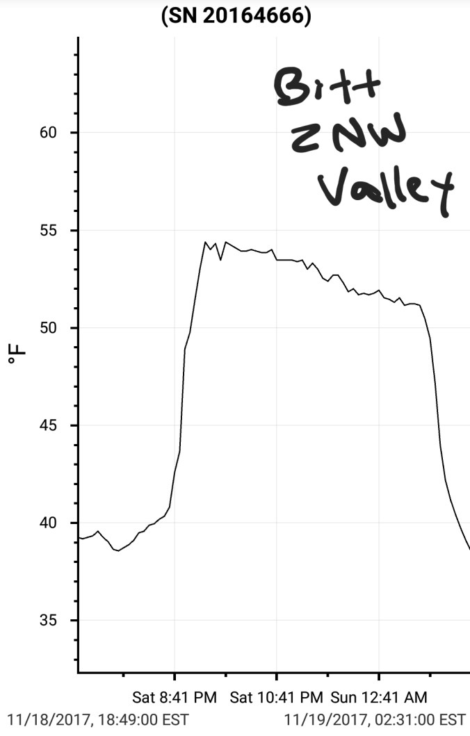
November 18.      min.      max.     avg

Bitt 2NW valley  22.9  54.3(latepm) 38.6

Garrett College 26.7     59.3           43

Can-Heights      40.6     54.9            47.8

CRN-Canaan    36.6      56.3          46.5

Cabin Mt         42.8        53.1         47.9

Cabin Mt north 40.3     53.6        46.9

Snowshoe/S.C.  37.2     52.7         44.8

Can-Valley Floor 28.6   57.3      42.9

Cresaptown    25.5        40.5        33

Green Bank Obs 23.1    59.2       41.2

7Springs          33.6       58.6         46

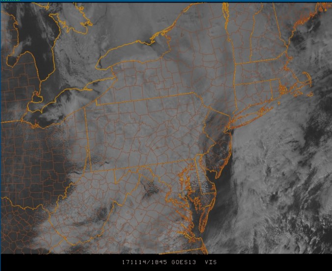
Wild temp day, and an incredible start. Overnight valleys ran into the low 20s. High Ground held 40s. A magnificent sunrise across portions of the area, with a double rainbow in the western sky as rain pushed in. This occured across Garrett County. A half hour after this sunrise, rainbows, high ground was mild and low lying cold air trapped in valleys. High valleys even. At Bitt 2NW valley I had a brief occurence of freezing rain. This gave way to straight rain but temps held 30s and briefly in the low 40s in the afternoon. At the time of this typing(6:49pm) max temp was 41 and current of 39. While likely temps will briefly surge before midnight and make the appearance of a uniform temp day in the area, it was anything but. The high ground in Wv rans 50s on strong winds, while valleys northeast held 30s, low 40s and calm. Valleys above 2500′ even. In Garrett Negro Mt once again is the border. Despite minimal elevation difference, south winds run up the west side, while east side remains in a different airmass(pics illustrate that nice) and the 3km nam did a fantastic job of nailing this. The temp detail in this model is 2nd to none. Rainfall was .5 to 1 inch Garrett, and north and less south.

Temp dam busted around 9pm at Bitt 2NW valley and fell around 2am the 19th. The 5 hour window will really give a misrepresentation of what both days were like on the max, min chart.

2017-11-18-11-50-51Screenshot_20171118-103920


November 17.     min.     max.    avg

Bitt 2NW valley  23.8(pm) 40.5  32.1

Garrett College    26.5        43.2   34.8

Can-Heights      25.1         44.3     34.7

CRN-Canaan     26.5         45.4     36.0

Cabin Mt         22.1(am)  44.1     33.1

Cabin Mt north 23.2       46.4     34.8

Snowshoe/S.C  21.7       45.7       33.6

Can-Valley Floor 22.4   49.6   36.0

Cresaptown  27.7         52.9       40.3

Green Bank Obs 23.2   51.7      37.5

7Springs   31.3           41.8         36.5

Day started with clouds north, clear south. Day was partly sunny. Warmer push from south warmed areas south of Garrett more than north.

Temps fell in valleys in pm hours. High ground did not.


3km nam did well again on temp setup hour by hour


November 16.       min.         max.      avg

Bitt 2NW valley   30.7          41.8       36.2

Garrett College     30.7         42.2      36.4

Can-Heights          26.1        40.4        33.2

CRN-Canaan         27.1         40.7       33.9

Cabin Mt.              23.4        37           30.2

Cabin Mt north   24.4         37.8        31.1

Snowshoe/S.C     22.8          37.6        30.2

Can-Valley Floor 28.4        44.0       36.2

Cresaptown     34.5            56.8         45.7

Green Bank Obs 30.8        47.6         39.2

7Springs         32             43.8             37.9


Max temps occuring pre dawn in many areas. Strong winds. Few peaks of sun early. Mainly cloudy. Very light precip, fog at dusk.

Wind gust 45+ on Cabin Mt.

Snowfall on the season is above normal across North America, but encroachment into the lower 48 has been slow over the past 10 days and has brought that above average down. Coverage should increase in the following week. 3rd pic is observed snowfall on the season.

Screenshot_20171115-121650


November 15.       min.     max.   avg

Bitt 2NW valley    19.8     41.1     30.4

Garrett College   25.9       43.3     34.6

Can-Heights      22.9        48.2      35.5

CRN-Canaan    20.9       47.7       34.3

Cabin Mt       23            44.8        33.9

Cabin Mt north 23.2    42.4      32.8

Snowshoe/S.C   27       43.5      35.2

Can-Valley Floor 13.2   51.6   32.4

Cresaptown  23          49.8      36.4

Green Bank Obs 17.6   45.9    31.6

7Springs      29.6       42.1      35.8

Day started off mainly clear. Pretty big temp inversions in the Wv mts. Teens to 30s. Se breezes through the day giving a cold feel to a good portion of the area. High cloud deck built and lowered later in the day. The morning inversions allowed Snowshoe to make snow at the base, but not on top.

3km nam performed very well. NWS forecast was fair, but still misses how the setup works.  -3 Canaan Heights +3 Bitt 2NW valley


Few things of interest- Southern Cabin Mt at Bald at 4350′ ran warmer, and +8 vs northern Cabin Mt. Wind direction was reading SW vs SE at Northern Cabin.


Not sure if Savage Mt broke 40° today. Some spots in Garret may held upper 30s.


2017-11-14-21-55-21Screenshot_20171114-182726Screenshot_20171114-144040.jpg


November 14.     min.      max.    avg

Bitt 2NW valley

Garrett College

Can-Heights

CRN-Canaan

Cabin Mt

Cabin Mt north

Snowshoe/S.C

Can-Valley Floor  23.6      34.3       28.9

Cresaptown

Green Bank Obs

7Springs

Overcast across majority of the mts with the high Alleghenies in the fog. Temps in the upper 20s across the high Alleghenies, and snuck into the low 30s in the southern high Alleghenies late day with a little clearing while north remained cloudy. Few breaks very late in Garrett. Southern Alleghenies had a little snow, flakes about into midday. As the fog lifted, it left a nice coat of rime. As seen in pics at Snowshoe, and in Canaan cam, off on Cabin to Porte Crayon if you look close.