2017-11-13-18-02-03


November 13.      min.      max.    avg

Bitt 2NW valley 33.0    41.3       37.1

Garrett College  34.1      40.2       37.1

Can-Heights    31.3        40.4        35.8

CRN-Canaan  31.8         40.6       36.2

Cabin Mt       28.9         37.9        33.4

North Cabin Mt 29.8    38.7       34.2

Snowshoe/S.C  28.9       38.8      33.8

Can-Valley Floor 32.6  41.5     37.0

Cresaptown    36.1       48.6     42.3

Green Bank Obs 36      45.6    40.8

7Springs      35.3         40.5      37.9

The day began with colder air in eastern Garrett County and some of the valleys off the east and North east.. Spotty freezing rain leaving isolated traces. Super Swiss Hd and 3km Nam hinted at this and done well. Further west and wv high ground, conditions were slightly milder. Light spotty rain, and fog was the issue. Fog was very thick at times today in these areas. Wv high ground fell to freezing afternoon and late day. Likely forming some rime. Further north, temps hovered upper 30s, low 40s and fell off at dusk.

2017-11-13-19-16-52Screenshot_20171112-185211


November 12.        min.    max.    avg

Bitt 2NW valley   20.0     51.8      35.9

Garrett College   22.8      52.8     37.8

Can-Heights    33.9       45.8   39.8

CRN-Canaan 28.4        47.3    37.8

Cabin Mt    33.3        44.8          39

Snowshoe/S.C  34.2    42.6      38.3

Can-Valley  29.3         50.5     39.9

Cresaptown   22.8      49.1       35.9

Green Bank Obs  22.3   45.9   34.1

7Springs   25.8         49.2      37.5

High clouds to start. Colder valleys vs high ground. 3km nam did well on the temps again. East of mts held cool, mts held steady. Mild push into Garrett with temps there falling more after dark vs high Wv ground. Clouds building in late day. Dew points rather low today throughout.  Risk of a light trace of ice exist tonight in valleys of Garrett, and east, northeast.

Snowmaking hours to date Wisp 48(none used), Snowshoe 41,(maximized)

Screenshot_20171113-190142Screenshot_20171112-191152Screenshot_20171111-181908

November 11.      min.      max.    avg

Bitt 2NW valley 11.3       28.6      19.9

Garrett College  13.1       31.4      22.2

Can-Heights.      12.4       36.6    24.5

CRN-Canaan      11.7      36.7     24.2

Cabin Mt.      10.2        36.0         23.1

Showshoe/S.C 16.2      37.8       27

Can-Valley Floor 7.6   39.4     23.5

Cresaptown    14.2       36.3     25.2

Green Bank Obs 11.9     37     24.5

7Springs.         13.9       33.2     23.5

High broken very thin clouds pushing in pre dawn. Light southern winds also pre dawn. Wv high ground reached their min temps hours before daybreak. Southeasterly breezes during the day kept Garrett colder than areas south. Illustrated in pics. 3km nam is once again near perfect hitting that setup. Snowmaking continued at Snowshoe all day despite temps creeping above feeezing, wet bulb/dew points very low yet. Seven Springs continued as well. Wisp was the coldest resort today, and will be again tonight, then moderation occurs tomorrow until Garrett north and east go below freezing tomorrow night until Monday morning.

2017-11-11-18-01-00.jpg


November 10.       min.      max.   avg

Bitt 2NW valley   12.7      39.0      25.8

Garrett College   15        39.1       27

Can-Heights      12.8       34.9       23.9

CRN-Canaan 12.6          36.7      24.7

Cabin Mt       9.6           31.6        20.6

Snowshoe/S.C 13.8       32.4       23.1

Can-Valley Floor 7.9     38.1      23

Cresaptown   20.1        44.8       32.5

Green Bank Obs  16.1    40.3    28.2

7Springs          16.3          41.1    28.7

High temps were midnight temps. Temps fell the greatest from predawn to 10am then stabilized to rising a few and dropping again at dark. Spotty snowshowers were light and scattered and skiffs occured here and there. A fair amount of sun occured throughout the day.

Seven Springs, Snowshoe began snow making.

Nov 9 snow extent

November 9th snow extent vs last year. Much much much ahead of where the North America snow extent was last year on this date. Actually the greatest snow extent for the date since the graph began in 02’… The northern hemisphere as a whole is in the upper echelon of snow extent for the date out of the past 12.

November 9.       min.      max.    avg

Bitt 2NW valley  30.3       47.0    38.6

Garrett College   34.2      46.3     40.2

Can-Heights.       34.6      44.2     39.4

CRN-Canaan      33.7       43.9      38.8

Cabin Mt           31.6        40.6      36.1

Snowshoe/S.C   32.4        41.4      36.9

Can-Valley Floor 33.4      45.9     39.6

Cresaptown   34.5          50.9     42.7

Green Bank Obs 31.2    47.9     39.6

Day began on the drizzly, foggy dreary side. That held until mid afternoon before things began to break. East of the Alleghenies, at least east of Garrett the low clouds, fog held until evening skirting the ridge tops down there.


November 8.        min.     max.    avg

Bitt 2NW valley   30.7      42.8    36.7

Garrett College   32.2       43.7    38

Can-Heights       30.1       44.4     37.2

CRN-Canaan   31.4        44.6      38.0

Cabin Mt     28.2          41.2        34.7

Snowshoe/S.C 32.5     39.6       36

Can-Valley Floor 31.3   49.3    40.3

Cresaptown   34.9       49.8      42.3

Green Bank Obs 35.3    45.7     40.5

*updated ice zones in pic 1…Still not certain how the Allegheny front did with ice.

Today began very foggy. Made driving difficult pre dawn. Northern Alleghenies held temps below freezing across higger terrain. Fog lifted around 8:30 -9:30 north and south of Garrett. It held on until mid to late morning across Garrett. Ice was pretty well melted off by early mid afternoon in areas that saw it as the sun broke out for a while.

2017-11-07-20-25-32.jpg

November 7        min.       max.    avg

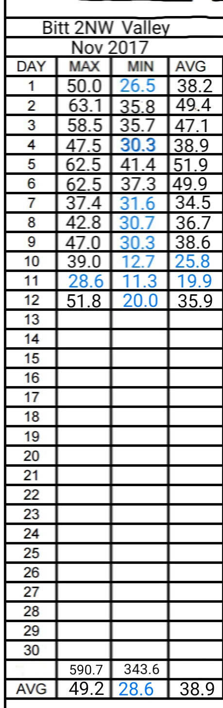
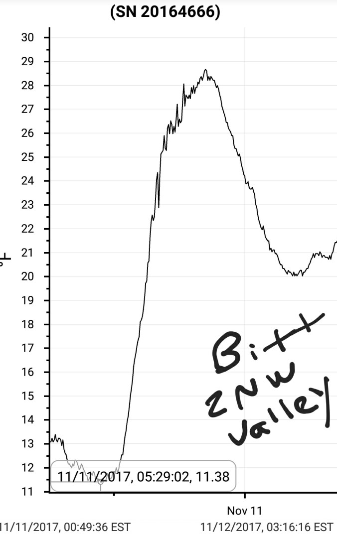
Bitt 2NW valley  31.6       37.4     34.5

Garrett College. 32.3        38.2     35.2

Can-Heights    30.9           44.8     37.8

CRN-Canaan 32.1            45.3     38.7

Cabin Mt   29.1             45.5        37.3

Snowshoe/S.C  34.7      47.5        41

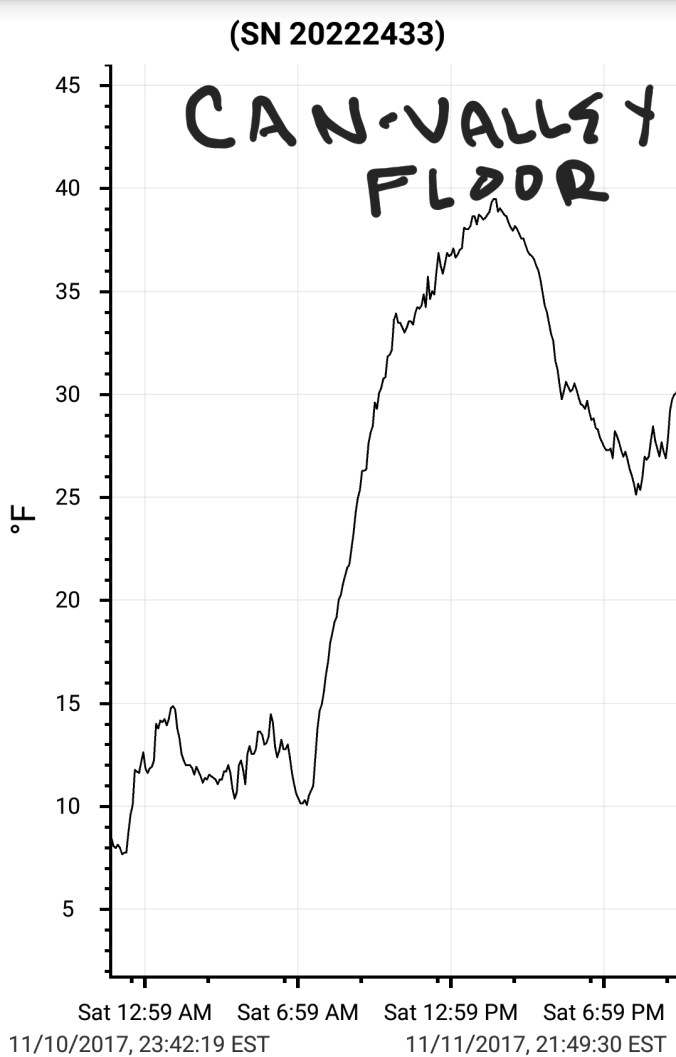
Can-Valley Floor 32.6   45.7     39.1

Cresaptown   36.3      42.4        39.3

Green Bank Obs 36.3   50.3     43.3

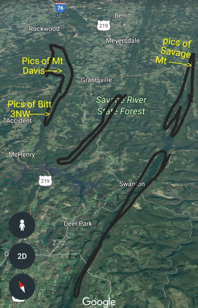
First pic, ice zones in Garrett County. Between Meadow and Savage there was spotty ice. West of Negro Mt, no ice, except at Keysers Ridge and just south on 219 at highest ele.

Today began with colder, drier air bleeding in from the northeast at the surface. With precip advancing in from the west. Temps were much colder across the northern Alleghenies, vs southern Alleghenies. Also just a touch colder in the higher eastern Alleghenies vs central and western Alleghenies. Typical of the setup thats repeated many times over the years. Dewpoints in low 30s, as precip moved in, temps made the move towards the dew point. Freezing broke out late morning in those circled areas.  Areas north in Somerset County into Cambria County Pa saw their first accumulating snow. East of the Alleghenies, some sleet and snow occured with the rain, surface too warm to stick.

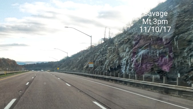
The short term models did well. 3km nam and the new super swiss hd model. In Garrett and southern Somerset County freezing rain was the issue. This however was only a high elevated event in these areas. Meadow Mt east, ice was at 2650′ and above. Savage Mt had a nice coating building early afternoon. Late afternoon at Mt. Davis a real nice coating. I’d say near .2 at Mt. Davis had occured and still adding. Further south along Negro Mt near Bittinger, ice was at and above 2800′ only. As seen below, My Bitt 2NW valley temps hovered just above freezing all afternoon.  Further south, little info on what occured aside Bald Knob went to 29° early afternoon and anemometer stopped, likely indication of ice. Temps were likely a little colder out towards the Allegheny Front. Which the northern extension of the Allegheny front is Dans Mt at 2900′ just east of Savage Mt and was collecting some ice.

Further south, 30s creeped down east side of the mts. Snowshoe held in 40s most of the day.

Rainfall amounts varied .5 to 1.0 north. Will touch more on that in separate post.


Screenshot_20171107-200646


November 6           min.     max.   avg

Bitt 2NW valley  37.3   62.5(mn) 49.9

Garrett College 38.1    64.2(mn)  51.1

Can-Heights  42.5         58.9         50.7

CRN-Canaan 43.6        57.1        50.4

Cabin Mt    41.2           55          48.1

Snowshoe/S.C 43.5     54.7       49.1

Can-Valley Floor 43.7   58.4     51.0

Cresaptown  37.2      68.4.       52.8

Green Bank Obs 41.8   64.4    53.1

(mn) = midnight high

Rainy overnight, and periods of rain all day. A brief glimpse of sun in parts of Garrett, Preston around 7:30am. Very brief. Temps slowly falling afternoon. Max temps were at midnight time period. Rain totals ran on avg an inch. A range of .75 to near 1.50 across northern Alleghenies, much less south.  Radar estimated pic posted is not exact, but gives a great illustration of the areas that saw best rains.

Posted on facebook about the potential freezing rain tomorrow in those typical areas most prone to it.

Snow cover for date also posted. As well as North America snow extent below which is the highest in 12 years. Screenshot_20171106-203304