


Jan 12. min. max. avg
Bitt 2NW valley 31.3 54.1 42.7
Garrett College 30.9 60.0 45.4
Can-Heights 33.9 57.5 45.7
CRN-Canaan 35.3 59.3 47.3
Cabin Mt 37.9 54.3 46.1
Cabin Mt north 31.1 56.3 43.7
Spruce Knob 38.3 52.3 45.3
Snowshoe/S.C 40.6 52.9 46.8
Can-Valley Floor 36.4 59.1 47.2
Cresaptown 41.4 62.8 52.1
Green Bank Obs 45.5 60.9 53.2
7Springs 30.3 57.5 43.9
After a windy, mild night that ate up the snow cover in many areas, only the sheltered cool valleys remained with snow cover. Cloud cover was dominant today, winds were very light, and periods of rain. Low lying fog at times due to cold waterways and ground.
https://m.facebook.com/story.php?story_fbid=1679085812178998&id=577901605630763
*Late addition- rainfall picked up after dark, transitioned to freezing rain by 10pm near Mchenry. Earlier North/West, later south, southeast.
Rainfall on the day
Garrett College 1.15
Canaan Heights 1.51
CRN at Canaan State Park 1.43
Spruce Knob 1.13
Images below, experimental low lying creek bottom “Refridgerated Affect”.. Really illustrates how these type of areas hold on to snow cover longer than elsewhere. 1- they are sheltered from worst winds 2- cold heavy air off snowpack lays low, hard for the winds to keep it mixed out. Looking at the fluctuations in temps overnight is quite impressive, and also to note, the sheltered spot, did not touch 50 in the warm spell and spent part of the night in the 30s, while many areas were 50+. A snowcover remained yet at 4pm.


Picture from near Clarion Pa, showing the ice break up and flooding(Reed Timer)
The front…on the move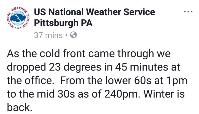


Area waterways…most gauges not reporting CFS at present. Yough at Friendsville is.
Pics below, screenshots from David Fuance video at Blackwater Falls today


Temp profile after dark as front is on the move
