Jan 21.               min.           max.         avg

Bitt 2NW valley  37.4         46.4         41.9

Garrett College   40.9         49.2         45.0

Can-Heights        38.0          45.6        41.8

CRN-Canaan       39.4          47.2         43.3

Cabin Mt             35.2          43.2        39.2

Cabin Mt north 36.7           44.2        40.4

Spruce Knob     35.6          41.9        38.7

Snowshoe/S.C   37.2           44.4       40.8

Can-Valley Floor

Cresaptown      43.7           60.5      52.1

Green Bank Obs 38.2        53.8      46.0

7Springs             40.4          49.8      45.1

Overall a cloudy dreary day. Some pockets of drizzle, high elevation fog. Winds subsided for the most part. Snow restricted to high spots, and lower sheltered spots. Otherwise drifts…


Temps today at Bittinger 2nw Valley and Cabin Mt 4350….2018-01-22-18-43-34


Temps nationally todayrtma_t2m_conus2

January through yesterdays date at Bittinger 2nw Valley2018-01-21-12-56-11

Jan 20.                   min.       max.         avg

Bitt 2NW valley   32.6        44.1        38.3

Garrett College    33.9       44.7         39.3

Can-Heights         29.5       41.3         35.4

CRN-Canaan        31.1        43.4        37.3

Cabin Mt              26.4        39.0        32.7

Cabin Mt north   27.9        40.3        34.1

Spruce Knob        25.3        39.0       32.1

Snowshoe/S.C       28.0       40.5        34.2

Can-Valley Floor

Cresaptown           36.9         59.6      48.2

Green Bank Obs   17.8         52.1       34.9

7Springs                 35.4         44.7       40.0

Windy overnight through today. Scattered clouds, plenty o sun.  Some low clouds this a.m early capping the high Wv locations in spots.

Temps at Bittinger 2nw Valley (through 6:30pm) and Cabin Mt 4350 (through 8:30pm)

Pics below by Stacy Fields Boggess at Red Creek Dolly Sods today


Pics below by Sarah Bailey at Blackwater Falls today


National temp profile todayrtma_t2m_conus2


Jan 19.             min.           max.          avg

Bitt 2NW valley  19.2        35.3         27.2

Garrett College   20.5        35.3         27.9

Can-Heights        16.9        34.2          25.5

CRN-Canaan        19.3        35.9         27.6

Cabin Mt               15.1        32.4         23.7

Cabin Mt north     16.0       33.1         24.5

Spruce Knob         15.3        33.8        24.5

Snowshoe/S.C        18.1       35.1        26.6

Can-Valley Floor

Cresaptown          26.8         54.0        40.2

Green Bank Obs  11.9         46.4         29.1

7Springs                 22.4        37.4        29.9

Mostly to partly sunny skies, few more clouds later, but mainly sun today.

Temps today at Bitt 2NW valley and Cabin Mt 4350


Snowcover off modis and national temp setup this afternoon. Snowcover hindering warmth in the Carolinas.


North America snow extent, followed by an animation link of the season to date

https://www.nohrsc.noaa.gov/nsa/js_animate.html?nsteps=110&year=2018&month=1&day=19&type=nsm_depth&region=National&ts=24&large=1

Screenshot_20180119-215431


Pics below by Rosanna Springston around the Highland Scenic Highway area today….


Sunset in Canaan Valley, pic by Vernon PattersonFB_IMG_1516501069193

Pic by Wtae Ray Petlin at 7Springs winterfest tonightScreenshot_20180119-210030.jpg

On this date in 1994, I recorded a -29° 4 miles south of Grantsville Md. Many locations recorded in excess of -20°


Jan 18.             min.           max.         avg

Bitt 2NW valley  4.6         23.1         13.8

Garrett College   4.6          23.9        14.2

Can-Heights        0.4          20.9        10.6

CRN-Canaan       1.7           24.1        12.9

Cabin Mt              -2.2         21.0        9.4

Cabin Mt north   -1.7        22.1         10.2

Spruce Knob        -2.7       23.7         10.5

Snowshoe/S.C       -2.4      22.1          9.8

Can-Valley Floor

Cresaptown           14.2      40.8        27.5

Green Bank Obs    -2.7      35.9        16.6

7Springs                  7.4       23.8        15.6

Light, fine crystallized snow last night with winds increasing and strong all night. The winds stayed up, but skies were clear, blue the entire day.

Snowfall last night

Bittinger 2nw Valley .7″ 57.6″ on the season

Can-Heights 1.0″ overnight 67.5 on the season

Data from Bittinger 2nw Valley, Cabin Mt 4350…. also to note wind gust at Spruce Knob was 40+mph


Pics from Snowshoe today from social media


Pic from CanaanScreenshot_20180118-112318


Snowcover and temps today….Carolina coastal areas the big wow here…will have pics further down with that. The affect of snowcover on temps vs no snow cover is evident.Screenshot_20180118-215222


Pics from the Carolina Coast off Social MediaFB_IMG_1516287585151


A few from Chincoteague/Assateague by Shane Whealton


A radar snippet from last night…notice the light return in Wv. Very cold temps, the least bit of moisture in the air fell…the cause of the fine, light crystallized snow overnight that not all sites reported. Some of which I know recieved it. Screenshot_20180118-195212

My Throwback Thursday… going back to Feb 1961. I would wait until Feb to post this, but I would likely forget, so I will now. This image south of Bittinger near The Glades on Rock Lodge Rd . The photo does not have an exact date, but I’d suspect it to be between the 8th and 12th of the month.


Jan 17.                      min.        max.       avg

Bitt 2NW valley    3.8           10.1        6.9

Garrett College     4.8            12.1       8.4

Can-Heights          0.2            10.7       5.4

CRN-Canaan        1.3             11.5       6.4

Cabin Mt               -2.4             8.4       3.0

Cabin Mt north   -1.1              9.1       4.0

Spruce Knob        -3.8             10.8     3.5

Snowshoe/S.C      -2.0              10.4    4.2

Can-Valley Floor

Cresaptown         12.9.            29.5      21.2

Green Bank Obs  -0.8             19.6      9.4

7Springs              3.6                11.9      7.7

Cloudy morning, fine light snow on and off. A break in that midday, with more fine light crystallized snow late afternoon into the overnight. Periods of sun occurrd with more of that as you went south.

Snowfall- Bittinger 2NW valley 1.6″  overnight .1″ today (storm total 6.0″) – 56.9″ on the season

Canaan Heights 3.7″ overnight (storm total 6.9″ ) 66.5″ on the season

Terra Alta in at 5″, 7Springs 4″, Snowshoe co-op 4″, website repots 5″, post says half foot. 5.3″ at Bayard

Temps at Bitt 2NW valley today2018-01-17-20-07-02

Cabin Mt at 4350 today (min should read -2.3)2018-01-17-20-56-30

Photo by Chip Chase at Whitegrass in Canaan todayFB_IMG_1516208637024

Snowshoe today from social media


Cold into the Gulf statesScreenshot_20180117-195038.jpg

Pics by David Hill on Blue Ridge Parkway today


National temps this afternoon and windchills. Alleghenies the nations cold spot


Pics by David Faunce at Blackwater


Pic below by Moments of Steffi Hone, check out that page on facebook. Germany Valley , Nelson Rocks, North Fork Mt in the distance. FB_IMG_1516367556520


Jan 16.               min.            max.          avg

Bitt 2NW valley  12.2           29.5     20.8

Garrett College  12.2            30.8     21.5

Can-Heights        11.1           29.9     20.5

CRN-Canaan       11.6           28.7     20.1

Cabin Mt             9.1             25.5     17.3

Cabin Mt north  9.3            27.0      18.1

Spruce Knob      10.6           25.2      17.9

Snowshoe/S.C     10.4           26.2     18.3

Can-Valley Floor

Cresaptown        21.6           32.7     27.1

Green Bank Obs  18.6         30.8     24.7

7Springs              11.9           27.4     19.6

Very light snow overnight, into the morning. It picked up late morning through the afternoon in Garrett and overall snow through the majority of the day…at times moderate, steady.

Snowfall Bittinger 2NW valley total 4.3″ through 5:30pm boardsweep.   .8″ at 9:30, 3.5″ from 9:30 through 5:30 —-55.2″ on the season

Canaan Heights 3.2″ through 7p.m. –62.8″ on the season


Radar seemed really persistent with returns in northern Garrett, southeestward into Preston County. It seemed to perform well with this system. As bitter cold comes back in overnight, lower cloud tops, radar will again overshoot the remaining leftover precip…  I’d expect reports from Preston to run a tad higher.


National radar 10pmScreenshot_20180116-221347

Bitt 2NW valley temps today.2018-01-17-08-38-41


Jan 15.               min.          max.         avg

Bitt 2NW valley   -0.6         19.8         9.6

Garrett College    5.0           25.6       15.3

Can-Heights         3.9           27.3       15.6

CRN-Canaan        2.3           27.8       15.1

Cabin Mt               5.2           25.2       15.2

Cabin Mt north    3.2           27.9       15.5

Spruce Knob        3.9            23.5       13.7

Snowshoe/S.C       5.5           24.4        14.9

Can-Valley Floor -5.0

Cresaptown          5.6            28.4       17.0

Green Bank Obs   -0.5          31.2       15.4

7Springs                 6.5           22.7       14.6

Overnight, conditions were mainly clear and calm. In some areas a very light east breeze remained in play. In Garrett County near Bittinger the Luke papermill smell was slightly evident. Even so, some areas fell below 0, and more so west and high Wv ground. Skies quickly clouded up after sunrise and a period of light snow occured mid to late morning. That passed and skies again cleared, folloed by clouds at nightfall and few flakes flying in Garrett by 7pm.

Bittinger 2nw Valley .1″ (a heavy .1 haha) of snow this a.m. 50.9″ on the season.

Pics below showing the mid to late a.m snow…


Lows this a.m, -5 on valley floor site at Canaan, -0.6 at Bittinger 2nw Valley, The Glades I believe was affected by the slight easterly component to the light wind


Piney Run in eastern Garrett high of 19 also with 19 with east flow.hires_t2m_wv_8.png2018-01-15-21-23-14

3km nam done well with todays temp setup


Jan 14                  min.           max.        avg

Bitt 2NW valley  -1.9           13.0         5.5

Garrett College    0.6            20.1        10.3

Can-Heights         -3.9           14           5.0

CRN-Canaan       -1.9            14.9        6.5

Cabin Mt             -5.4             10.4       2.5

Cabin Mt north  -4.4             16.3      5.9

Spruce Knob       -5.6             17.1     5.7

Snowshoe/S.C     -2.4             19.4     8.5

Can-Valley Floor -7.6            20.4    6.4

Cresaptown         9.7             29.1     19.4

Green Bank Obs  2.0            25.3      13.6

7Springs               5.7             16.6      11.2

The Glades           -5.5

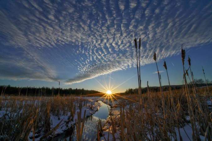
Clear skies, calm morning. Leading to lots of below 0 readings up high, and the valleys in the mts, and out of the mts as well. To note, a better snowpack west of the mts. . Only clouds to start was coming off the ski resorts, other than a few in the NW skies. Over night some fine crystallized snow fell. Party to mostly sunny skies through the day with some late day clouds.

Snowfall

Bittinger 2nw Valley .4″ overnight 50.8″ on the season

Canaan Heights .3″ overnight 59.3″ on the season.

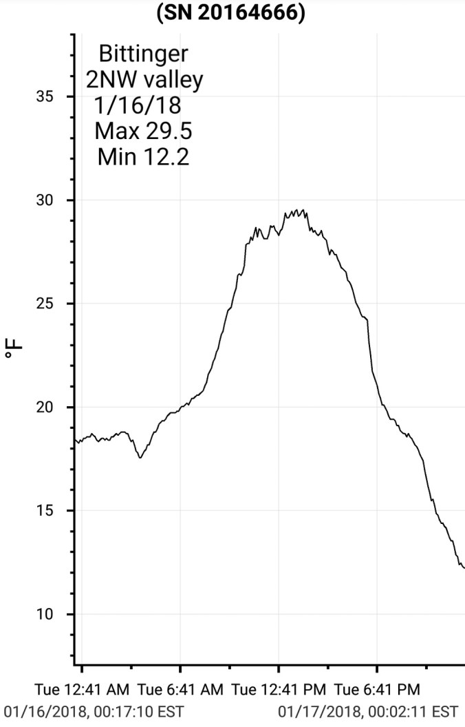
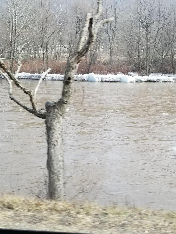
Pic below, Bittinger 2nw Valley temps today

2018-01-14-18-36-52


Pics below, by Mallory Richards at Gaudineer Knob


Pics below by Jeremy Cutlip, at Falls of Hills Creek and Highland Scenic Highway


Pics below by Vernon Patterson at Dolly Sods


Pics below by David Miller/Allegheny Photography. Check out his website and Facebook page (Allegheny Photography) Dolly Sods in the pics.  Sunrise from Cabin Mt, and left fork of Red Creek in pics.


Pics Below by Rick Burgess at the Sinks and 2 from Spruce Knob


FB_IMG_1516072514424


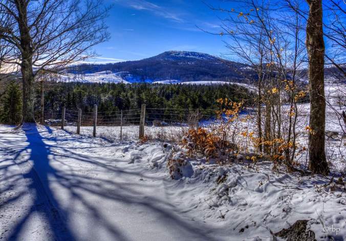
Pic below from A_Katharine on Instagram from Olson Tower on Backbone Mt in Tucker County

Screenshot_20180115-131442

Pic Below by Michael James Baer at the Susquehanna River in HarrisburgFB_IMG_1515973789832.jpg

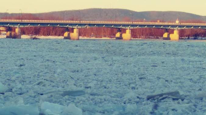
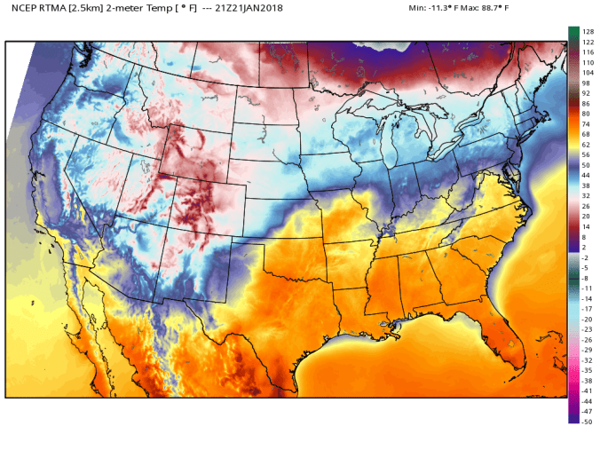
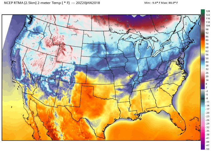
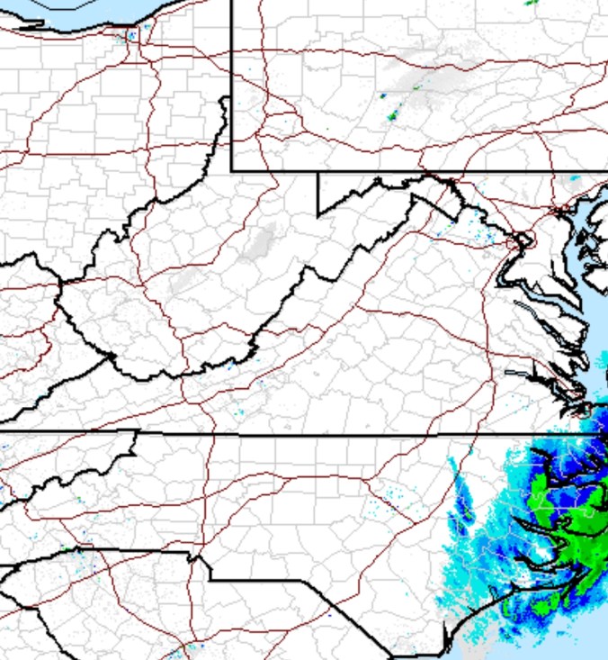
Mjo cycling through and headed towards the warm phases. 500mb looks on target with it with sharp trough heading towards the eastern Pacific and going into the west coast. SST setup doesn’t favor a trough sitting there, but the MJO looks like a bigtime driver currently. This would lead to a mild period with a poor storm track. Its not though etched in stone this period ahead day 7-15 , can’t produce snow. Climatology speaking its the coldest period of the year, and above average temps does not mean no snow. I would suspect though, we will have a few good rain systems in that period as phase 4 Mjo is wet and mild.


Current sst look and 7 day change.


The Eastern tropical Pacific in enso 1.2 is still the coldest, this accompanied by current east qbo and sst setup off east and west coast should thwart off straight warmth through the warm mjo phases. The big SE ridge will try to build and retrograde back but struggle to feedback with SE waters much cooler than last winter with cool anomlies in close and warmer off the coas.  With nina east based, with a soi rise, west coast warmth, the Pna likely holds only slightly negative. Epo goes positive and that is a warm signal. Ao and Nao each going negative and typically a cold signal, but in the pattern look to only be minor players in the 7 to 15 day. Not total non factors.

Conclusion, milder than average, wetter than average. Unfavorable storm track. Enough factors that are favorable that timing could lead to a slightly suppressed storm, or with some blocking, a storm moving slow once to the coast and backside snows as the rain passes. No brutal cold looks likely in the period.

Further out. Watch stratospheric warming event, mjo going back to favorable phases. Sst anomalies look decent. Teleconnectins of -epo, + pna looks more favorable. Can we get some good blocking and favorable storm track. Remains to be seen.


Jan 13.                 min.            max.        avg

Bitt 2NW valley  6.3             31.5         18.9

Garrett College   7.6             30.6         19.1

Can-Heights        4.5             33            18.7

CRN-Canaan       6.5             36.7         21.6

Cabin Mt             1.8             38.3         20.0

Cabin Mt north 2.5             30.7         16.6

Spruce Knob      1.0            38.7          19.8

Snowshoe/S.C    2.7            40.8           21.7

Can-Valley Floor 6.9           36.4         21.6

Cresaptown       16.2            40.8         28.5

Green Bank Obs 10.6         45.4          28

7Springs               8.4           30.6         19.5

Snow at varying rates through midday, then subsidibg aside a few stray snowshowers. Midnight highs with falling temps through the morning and holding steady. A period of freezing rain, sleet occured last night before the change to snow. The main snow for the mts was high ratio fluff upslope.

Bittinger 2nw Valley snowfall 3.4″ of fluff overnight today. 2.8″ by 8am, .6″ over next 6 hours through 2pm. New snow depth by 4pm around 3″.  This in a wind protected area. High spots 2″+/- windblown settled snow. Not the fluff factor – 50.4″ on the season

Canaan Heights 2.4″- 59.0″ on the season

http://data.canaanmtnsnow.com


Snowshoe, 7Springs cams from this a.m. above. Bittinger 2nw Valley below for today

2018-01-13-20-25-01

Photos below by Friends Of Blackwater on Facebook


Photo below by Jeremy Cutlip near Marlinton todayreceived_2080455685507050.jpeg

Video of ice flow near OhioPyle on Laurel Hill Creek

54 years ago today, B-52 crash in Garrett County on Savage Mt. Weather played a huge role. Story in the link below

http://buzzonefour.org


Jan 12.                   min.          max.        avg

Bitt 2NW valley  31.3           54.1       42.7

Garrett College    30.9         60.0        45.4

Can-Heights          33.9        57.5        45.7

CRN-Canaan        35.3         59.3       47.3

Cabin Mt               37.9           54.3      46.1

Cabin Mt north   31.1           56.3       43.7

Spruce Knob        38.3           52.3      45.3

Snowshoe/S.C       40.6           52.9      46.8

Can-Valley Floor  36.4         59.1       47.2

Cresaptown           41.4          62.8      52.1

Green Bank Obs   45.5           60.9     53.2

7Springs                 30.3           57.5     43.9

After a windy, mild night that ate up the snow cover in many areas, only the sheltered cool valleys remained with snow cover. Cloud cover was dominant today, winds were very light, and periods of rain. Low lying fog at times due to cold waterways and ground.

https://m.facebook.com/story.php?story_fbid=1679085812178998&id=577901605630763

*Late addition- rainfall picked up after dark, transitioned to freezing rain by 10pm near Mchenry. Earlier North/West, later south, southeast.

Rainfall on the day

Garrett College 1.15

Canaan Heights 1.51

CRN at Canaan State Park 1.43

Spruce Knob     1.13


Images below, experimental low lying creek bottom “Refridgerated Affect”.. Really illustrates how these type of areas hold on to snow cover longer than elsewhere. 1- they are sheltered from worst winds 2- cold heavy air off snowpack lays low, hard for the winds to keep it mixed out. Looking at the fluctuations in temps overnight is quite impressive, and also to note, the sheltered spot, did not touch 50 in the warm spell and spent part of the night in the 30s, while many areas were 50+. A snowcover remained yet at 4pm.


Picture from near Clarion Pa, showing the ice break up and flooding(Reed Timer)2018-01-12-16-59-19.jpg

The front…on the moveScreenshot_20180112-152002


Area waterways…most gauges not reporting CFS at present. Yough at Friendsville is.

Pics below, screenshots from David Fuance video at Blackwater Falls today


Temp profile after dark as front is on the movertma_t2m_conus2