Jan 11.                  min.           max.        avg

Bitt 2NW valley  24.8          55.7         40.2

Garrett College   31.6          58.1         44.8

Can-Heights         42.7         54.7         48.7

CRN-Canaan        41.0          55.8         48.4

Cabin Mt              41.9          52.9          47.4

Cabin Mt north  41             52.7          46.8

Spruce Knob        39.2          48.2         43.5

Snowshoe/S.C      39.6           49.3        44.4

Can-Valley Floor

Cresaptown          26.1            56.1       41.1

Green Bank Obs  32.7           55.6        44.2

7Springs                35.9           57.4        46.7

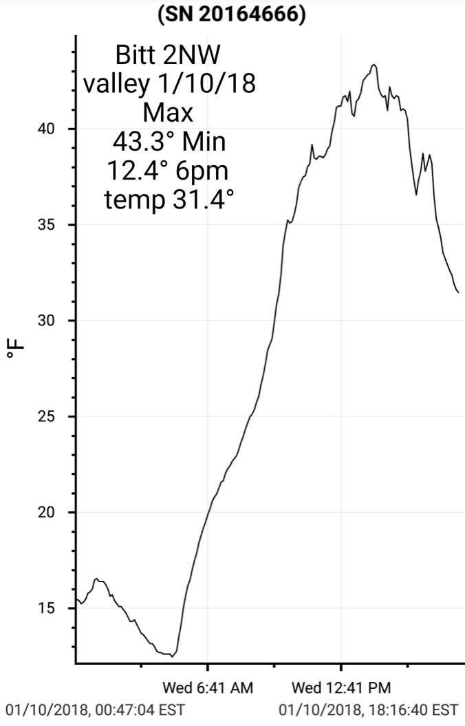
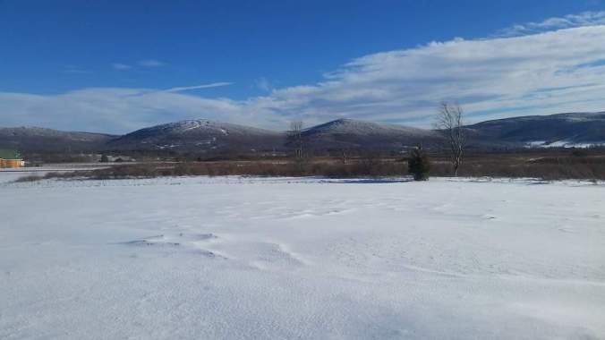
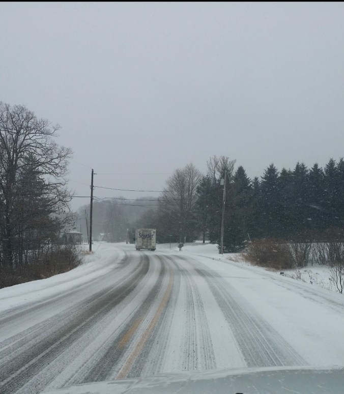
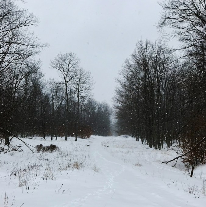
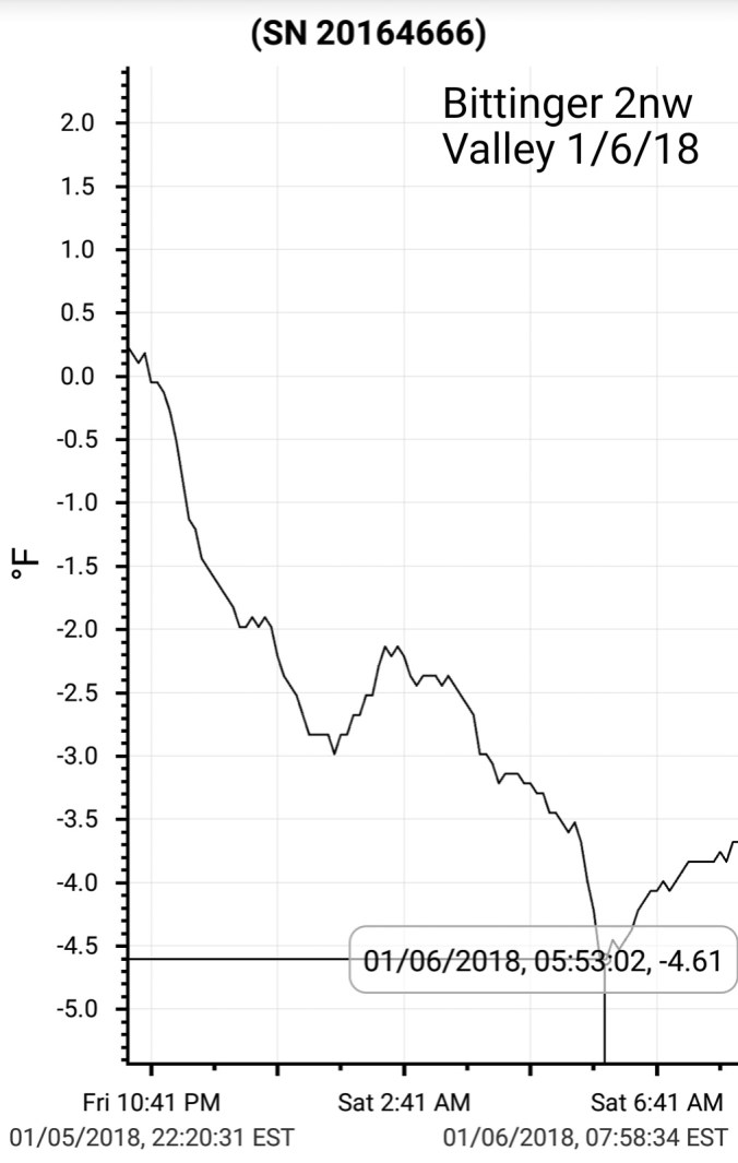
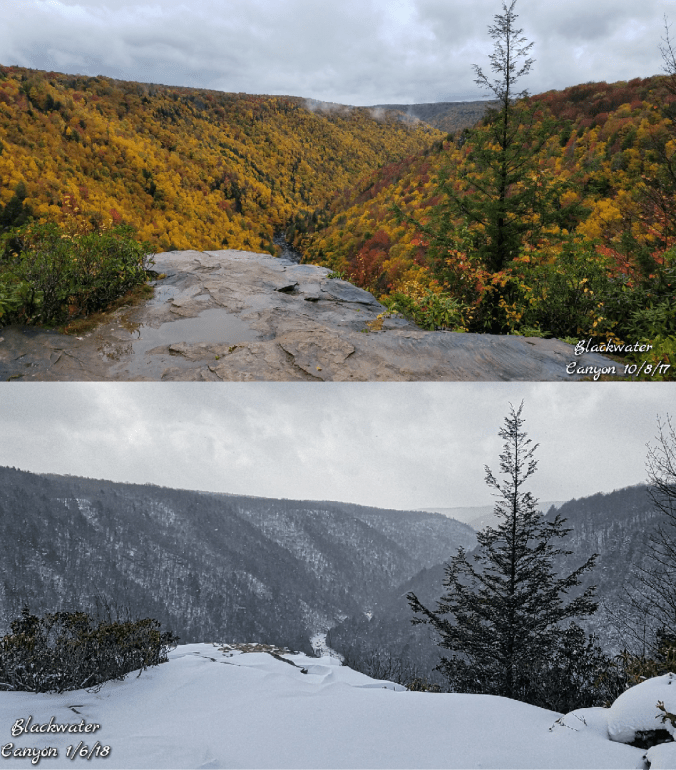
The day began with partly cloudy skies and cold valleys and mild high ground. At 8am at Bitt 2NW valley I had 25 while Garrett College at nearly same elevation a short distance away had 44. Skies clouded over at times and breezes picked up. Valleys held cooler, with light winds. Showers at nightfall and breezes holding up temps. Snow eater.

I did a little experiment in a sheltered valley spot. A location with a snowcover that gives the ” refrigerated affect “. Like a cooler, the snow cover keeps the lower areas cool with calm winds. As light breezes mixed in, it eould mix out some of the chill and it returned as the breeze passed by.


At one point temps rose +4° and dropped 2° all within 90 seconds. Great example of the breeze affect in the cooler. The sensor was set on 5 second intervals. Overall maxes were much cooler here as well as the breezes were not enough to mix out the chill from the snowcover with the sheltered location.

Garrett College and Bitt 2NW valley early morning


Jan 10.                    min.           max.      avg

Bitt 2NW valley    12.4          43.3        27.8

Garrett College                      45.4

Can-Heights        27.7            45.5       36.6

CRN-Canaan       22.6             46.8       34.7

Cabin Mt              29                45*       37

Cabin Mt north   29               47.1       38.0

Spruce Knob        30 *           40 *        35*

Snowshoe/S.C      35.1           41.5       38.3

Can-Valley Floor

Cresaptown.       *           *             *

Green Bank Obs 21.4            44.5      32.9

7Springs                27.1           45.8      36.5

The day began on the cloudy side. Cold valleys, milder high ground. Skies had some breaks by midday and more yet late day. Eastern ridges held a more E/Se component to the wind. Savage Mt held much cooler than towards Terra Alta.  The 3km Nam did very well at the setup as it typically does. Pictured below


Its hourlies did well. Showing central Garretts warmest period around 2pm and a retreat by 4pm. Exactly what I saw at Bitt 2NW valley (Pictured below)2018-01-10-19-03-27

Screenshot_20180113-123919

Jan 9.                    min.           max.      avg

Bitt 2NW valley 16.6            34.3       25.4

Garrett College  28.5.           33.9       31.2

Can-Heights       25.9            29.7        27.8

CRN-Canaan      25.5            34.6        30.0

Cabin Mt            23.7            29.1        26.5

Cabin Mt north 24.6            28.8        26.7

Spruce Knob     24*              29           26.5

Snowshoe/S.C    25               33.1        29.0

Can-Valley Floor

Cresaptown               *           49.3

Green Bank Obs.        *          44.8

7Springs                26.7          32.1       29.4

* missing and estimated. Weatherunderground tables failed to store data.

Day began with fog across the high ground after some areas experienced a little freezing drizzle, mist overnight with temps below freezing. Rime built across some of the Wv high ground. As the skies broke, Canaan was beautiful this afternoon. Skies broke late morning, early afternoon across most the area.

FB_IMG_1515543864185

Photo above today by Golden Anchor Cabins in Canaan. This took from their rental in Canaan. Looking for a great place to stay, check them out. https://www.goldenanchorcabins.com

ncep_cfsr_noram_t2m_anom

The cold opening to January…..


Jan 8.               min.              max.        avg

Bitt 2NW valley 15.7         34.5        25.2

Garrett College  31.1          35.3       33.2

Can-Heights       26.7          32          29.3

CRN-Canaan       22.1         32.5       27.3

Cabin Mt              27.7        31.8       29.8

Cabin Mt north  28.6         31.3       30

Spruce Knob      25.9         31.8       28.8

Snowshoe/S.C    29.7          34.5      32.1

Can-Valley Floor

Cresaptown       17.1           47.5      32.3

Green Bank Obs 8.4            34.2      21.3

7Springs             30.4           38.7      34.5

Cloudy, snow breaking out early across Garrett, Snowshoe. Canaan a tad later. Snow continuing through the day. Tapering 2pm north, and later Wv mts.

Temps at Bitt 2NW valley today2018-01-19-22-13-47


Canaan Heights reporting 3.4″

Bitt 2NW valley 1.7″ 47.0 season to date. Temps creeping above freezing below 3000′ killed rate increase when the snow was light. Some higher reported totals near Cranesville.

Early morning valley pockets colder than high spots.Screenshot_20180108-124554

Mosser Rd Mchenry midday. Photo by Jeremy BrennemanScreenshot_20180108-163024

Canaan Valley, photo by Renee MorrisScreenshot_20180108-184139

Snow analysis…looks pretty accurate.

Screenshot_20180108-115617

Social media pic by Justin Berk


Jan 7.                  min.            max.         avg

Bitt 2NW valley  -16.0         25.3         4.6

Garrett College  -8.5           29.1         10.3

Can-Heights        -10.4        25.8          7.7

CRN-Canaan       -10.1        28.1         9.0

Cabin Mt             -9.0           26.8        8.9

Cabin Mt north  -7.8          26.2        9.2

Spruce Knob      -9.9          25.7        7.9

Snowshoe/S.C     -6.7          27.9        10.6

Can-Valley Floor -23.6

Cresaptown        -2.5          27.7        12.6

Green Bank Obs -14.7       28             6.7

7Springs             -5.4           32            13.3

The Glades       -21 hobo, -23 accu rite mins only

Skies cleared and winds for the most part went calm overnight. Allowing temps to drop. Not as much as I expected, but still very cold. Today some high overcast built in. The sw return flow kicked in across the Wv high ground before dawn. Temps rose to the positive side of 0 there. Some notable temps, Terra Alta, a station south of there dropped to -19, one near Davis -16…

Below overnight temp comparison of The Glades and Bitt 2NW valley. The Glade experienced light breezes mixing out the cold through the night. Bitt 2NW valley had a gradual cool down.


Screenshot_20180107-192045

Graph by Dave Lesher. Through the 13 day period, this ranks #1 for the valley records in Canaan for the coldest 13 day stretch. Screenshot_20180107-192319

Graph by Dave Lesher. 1st 7 days of January at locations in Canaan


As cold air departs, Big Savage holds on to it the longest. This afternoon was no exception. A NE wind held as just west was experiencing a westerly component. With higher temps

ChesapeakeBayWatershed.2018007.terra.250m.coast+borders

Satellite view today. Snowcover in the mts. Also high cloud cover pushing in the mts/points west. Snowcover still visible. Snowcover from the storm a few days ago very visible along the eastern seaboard. Check out Delaware Bay and the ice cover!!


Temps comparison of The Glades and Canaan Valley floor, the mixing and drastic ups n downs at The Glades. I experienced on my walk in to log the temps. Tree leaves rustling on the dried beech, then sudden calmness.

Also a comparison from Canaan Valley floor to atop Bald Knob on Cabin Mt. Ot began to rise up high overnight and by 7:35 it was +4, while the valley floor was -23.6°. A  27°+ swing.

Screenshot_20180107-212554.jpg

Social media pic

Photos by Amy Zook, Lewes Beach Delaware.Screenshot_20180108-065633


Jan 6                       min.       max.         avg

Bitt 2NW valley   -4.6         5.7          0.5

Garrett College    -3.8        3.9           0.1

Can-Heights         -8.2        -0.5         -4.3

CRN-Canaan       -6.6         -0.6         -3.6

Cabin Mt             -11.2       -4.9         -8.1

Cabin Mt north  -10.3       -3.6         -6.9

Spruce Knob      -12.1       -5.1          -8.6

Snowshoe/S.C    -9.6          -4            -6.8

Can-Valley Floor -6.0       5              -0.5

Cresaptown        4.5         16.7        10.6

Green Bank Obs -1.8        6.6          2.4

7Springs              -2.3         5.1          1.4

The Glades          -5.0

Cloudy with breaks of sun, fine snow at times, windy. Windchills exceeding -40 overnight on northern Cabin Mt.

Snowfall .9″ new snow past 24 hours through 5pm Bitt 2NW valley 45.3″ on the season2018-01-08-14-24-21


Same view, differen season20180107_220651.png


Photo by Jesse Thornton, check out his Facebook page “Reflection In a Pool

“A Cranberry Winter”

“Snow falls on the distant hills surrounding Cranberry Glades of West Virginia looking out across the field of stick figures leading to the ethereal evergreen pines standing in contrast to the stark elements of winter.”

FB_IMG_1515454284773


Jan 5.                   min          max.         avg

Bitt 2NW valley   -4.5        2.9           -0.8

Garrett College    -3.6         3.0          -0.3

Can-Heights         -5.2          -1.6        -3.4

CRN-Canaan        -4.8         -0.0        -2.4

Cabin Mt             -8.9          -4.4       -6.6

Cabin Mt north -8.1           -3.3      -5.7

Spruce Knob      -8.7         -4.9       -6.8

Snowshoe/S.C    -6.7          -2.9       -4.8

Can-Valley Floor -3.2        2.3         -0.4

Cresaptown        6.3          16.4       11.4

Green Bank Obs 1.4          5.9         3.7

7Springs              -2.8          3.8         0.5

Some very fine light snow, mainly airborn windblown snow. With fine periods of snow with intervals and times of sun. Wind remained up all day. Exceeding 50mph across Cabin Mt. Wv high ground 35-40 below windchills. exceeding -20 most places.

Snowfall Bittinger 2NW 2.4″ through the 24 hour period from 4:30 yesterday. 44.4″ on the season.


Jan 4.                      min.        max.       avg

Bitt 2NW valley  -0.1         11.7        5.8

Garrett College   0.9           14.4       7.6

Can-Heights        -4              9.4       2.7

CRN-Canaan     -2.3            13.2     5.4

Cabin Mt         -7.2              7.9       0.4

Cabin Mt north  -6            9.1       1.6

Spruce Knob    -8               8.1       0.1

Snowshoe/S.C   -5.4            10       2.3

Can-Valley Floor -1.6         9.8      4.1

Cresaptown        11           25.9      18.5

Green Bank Obs. 2.3        14.1      8.2

7Springs             1.2          15.3      8.2

Snow breaking out around dawn. Steady snow at varying rates through the day. The western upslope appears to have done much better. Temps slowly falling all day. High winds throughout the day. Blowing and drifting the fluff. Snowfall around Cranesville from reliable source said to be around 6″

Bitt 2NW valley snowfall through 4:30pm was at 3.2″ of fluff. That puts season to date total right at 42″


Very strong storm bombing out as it moved up the coast today. Had it been a few hundred miles west, it would have been a major blizzard back here in the mts. . As was, upslope snows off NW winds was the theme, while coastal areas picking up good accumulations.


More from the storm…


More from Chincoteague…

FB_IMG_1515127499887

Ocean City Md


From Facebook


Jan 3.                      min.       max.       avg

Bitt 2NW valley  -14.8       23.6       4.4

Garrett College   0.3          25.9       13.1

Can-Heights         0.9         20.2       10.6

CRN-Canaan       3.6          20.9        12.3

Cabin Mt             3.4          17.4        10.4

Cabin Mt north  3.7         19.2        11.5

Spruce Knob      3.9          18.9       11.4

Snowshoe/S.C   10.0          19.9      14.9

Can-Valley Floor -24.6      25.3      0.3

Cresaptown       -0.2          29.7      14.8

Green Bank Obs  -13.1     24.2       5.6

7Springs             4.4          24.7        14.6

Large temp swings to begin the day. Coldest valleys running around +/- of 20 below, while hilltops rose after holding above 0 all night. Cloud cover pushed in today form the southeast..From a storm that brought accumulating snow to Georgia, S.C and snow into northern Florida. This is heading up the coast but east of the area.Screenshot_20180103-215304Screenshot_20180103-073826Screenshot_20180103-214013


Bittinger 2nw Valley, The Glades and Cassleman valley just from vehichle thermometer druving through.. also a -17 in Jennings reported, and a -20 in the bottom on Frank Brenneman Rd.  While it was -17 to  -24/25 below in these spots, Keysers Ridge was at +11.


The recipe to hone in on valley lows last night. The Gfs usually will hint strongly when cold valley lows will occur on 2meter temp parameter. It showed nothing under 0. 3km nam held all below 0 well west of the mts. That too did not look right. With calm, extreme low dewpoints, snowpack…temps had to fall. The valleys west in mts dropped first. Bruceton Mills area had valleys -10 by 10pm last night.

Screenshot_20180103-081342

Morning radar


Few snaps of impressive south east snow…


Jan 2.                   min.           max.          avg

Bitt 2NW valley -4.4          9.8             2.7

Garrett College  -1.7          10.4           4.3

Can-Heights       -7.7          8.2            0.2

CRN-Canaan      -6.6          10.1         1.7

Cabin Mt           -10.8         6.1           -2.4

Cabin Mt north -9.6         7.5            -1.1

Spruce Knob      -12.3       10.0         -1.2

Snowshoe/S.C    -9.6          12.2        1.3

Can-Valley Floor -6.8        14.7        3.9

Cresaptown         6.1          28.2        16.5

Green Bank Obs  -12.5      22.4         4.9

7Springs            1.9             10.2        6


Day began with some fine crystallized snow falling and gave way to blue skies quickly.  Temps at high ground in Wv came with windchills exceeding -30. After dark, the deeper valleys west side of the mts fell off fast. As cold as -10 near Bruceton Mills by 10pm.

picked up .4″ of snow overnight at Bitt 2NW valley. Season total at 38.8″

Canaan Heights .8″ 24 hour period at 7am for a total of 48.6″ on the season

a trace fell after 7am at both locations before clearing skies


Chincoteague Bay freezing up on the coast..ChesapeakeBayWatershed.2018002.terra.250m.borders

Modis Subset showing the snowcover in mts and nothing east of the mts….also shows coast lines freezing up.