Feb 28.                    min.        max.    avg

Bitt 2NW valley    26.9       57.9    42.4

Garrett College     30.9       57.6    44.2

Can-Heights          39.1       52.0    45.5

CRN-Canaan         39.5       53.2     46.4

Cabin Mt              37.8        48.7     43.2

Cabin Mt north   38.5       50.7      44.6

Spruce Knob         34.9     45.9      40.4

Snowshoe/S.C        37.6     46.0      41.8

Can-Valley Floor

Cresaptown          31.8       67.8    49.8

Green Bank Obs  27.6       53.9    40.8

7Springs               40.2       60.4     50.3

More clouds than sun today, but a mix of both. Few sprinkles midday. Breezy.

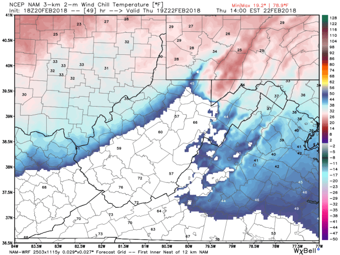
Temps today at Bittinger 2nw Valley and Cabin Mt 4350, as well as national temp profile this afternoon

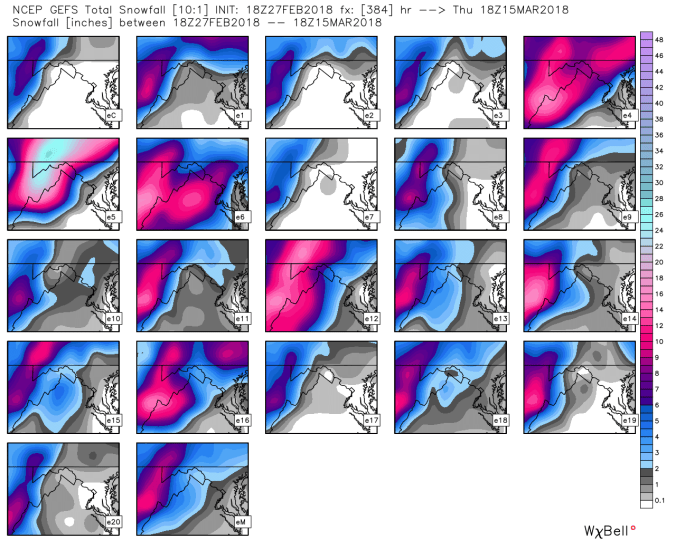
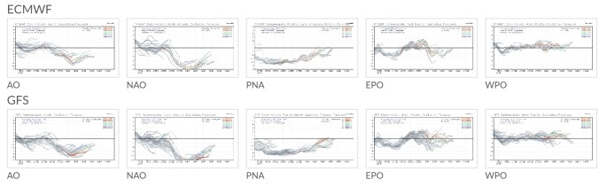
What do the models show for snow?Well as yesterdays runs trended towards signs of increased amounts, todays did the opposite. Right now, 3-6″ Wv mts, 2-5″ Garrett, Preston and north in Pa mts.  Here’s a quick rundown of the models.

(1)Super Swiss Hd, (2) 18z GFS, (3) 12z ECMWF, (4) 0Z NAM

They are all pretty well in the same ballpark, except the Swiss Hd and that model may be overkill on the mts.

Still,  will not at all be surprised to see amounts bump back up a little. This has some similarities to the April 2016 setup once the upper level low is in the coast. This isn’t trapped in though and will be able to skirt and be far enough east, we get shut off quicker from our upslope. Those options were heavy on the 12zecmwf yesterday. Again, as stressed yesterday. Models are still adjusting, getting a handle on all the pieces to the puzzle. Even if this changes some when it becomes a “nowcast” event, and in the end, models blew timing, track, deepening of the low, that too will not be surprising.

Winds still look to be on the extreme side.

30-50mph gust for most with 50-70mph across high exposed Wv mts above 3500′.. Saturated ground from all the recent rain, high winds, duration of the sustained wind with those gust may be enough to topple trees in spots and cause power outages. I’d be more prepared for this aspect currently than any other aspect with the event.

Pittsburgh NWS …given the current model output, this looks pretty good.

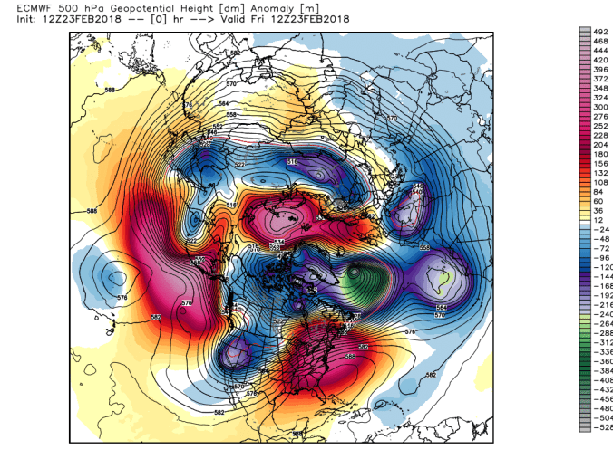
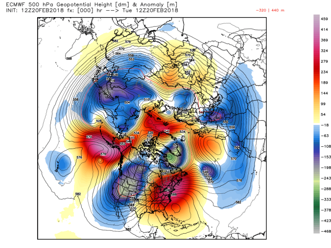
February 2018 temp and precip anomalies

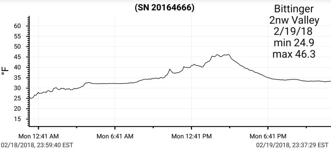
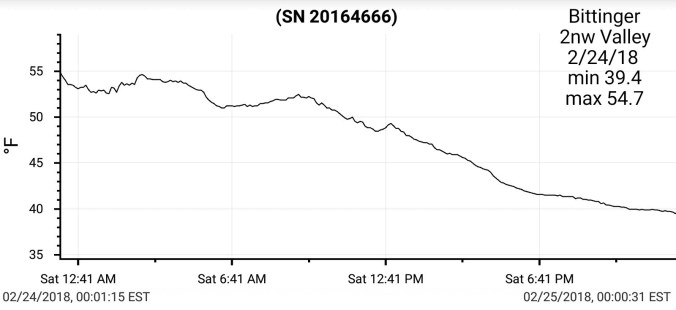
February temps at Bittinger 2nw Valley2018-03-06-11-53-50

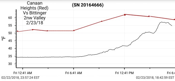
February temps across the Canaan area. Averaging slightly warmer than north central Garrett and points NE. That undercutting east flow occured quote often in the second half of the month as well as the valley affect influence

Data compiled and put together by Dave Lesher. 2018-03-06-12-03-19


Feb 27.               min.        max.    avg

Bitt 2NW valley 19.1     51.1    35.1

Garrett College 24.5     54.6     39.5

Can-Heights      19.6      50.1    34.8

CRN-Canaan      24.0      52.6    38.3

Cabin Mt            24.3      48.6     36.4

Cabin Mt north 27.1      49.8    38.5

Spruce Knob      25.0     47.1    36.0

Snowshoe/S.C    27.5     47.1    37.3

Can-Valley Floor

Cresaptown       25.0      62.4     43.7

Green Bank Obs 16.8     54.1    35.4

7Springs           32.4        53.8     43.1

Clear, frosty start, blue skies for most of the day until a few high wispy clouds rolled in.

Temps at Bittinger 2nw Valley and Cabin Mt 4350 today as well as the national temp profile this afternoon. Things got mild after cold start. Air remained very dry


Cold morning allowed for snowmaking at Snowshoe. Only resort in the area on the make.


Thursday into Friday. Comparing the 12Z ECMWF and 18z GFS. Noticeable differences. The 18z closes off the low top to bottom in closer to the coast, and therefore its slower to move out and precipitation, which will be snow will linger longer. The 12z Euro isn’t bad, but its more progressive and slower to close off the low and its further out to sea, and allowed to escape a tad quicker. Not huge differences, and doesn’t necessarily mean less impactful, it would shorten duration of impact. These details will continue to trend, and forecast tweaked in the coming days.

Whats it look like now.

The 12z ECMWF- Precip Type/Kuchera Snowfall amounts/Wind Gust/Temps

Rain to snow overnight Thursday, and continuing through Friday afternoon before ending in the evening. Snowfall amounts 4-8″ (leaning low) , winds 30-50mph for most, 50-70+mph across the Sods, Plains, to Spruce Mountain, temps falling into the 20s predawn Friday and holding.


Low Positions, Gfs closed in close, Ecmwf a wide variety of members off the coast further. So, does it close off in close? At all? How fast does it diddy bop around before escaping? This has room to become more impressive, or less yet with 2 days to go. GFS looks best at the moment.


GFS at 18z

Precip- rain to snow Thursday night, continuing in and through Friday, Friday night and a scattered fashion into Saturday afternoon. Snowfall 4-8 Garrett, Somerset, Fayette, Preston, 6-10 high Wv Mts.

Winds 20-40mph most areas, 35-60mph Sods, Plains, Spruce Mt.

Temps falling into 20s predawn Friday, hold through Sunday.


Ensemble members off the 12z ecmwf. This illustrates the wide range of solutions on low placement of the Euro. As the GFS members are more grouped together.

12z ECMWF ensembles


18z GFS ensembles, if you look at the GFS solutions above, shows very clearly why its more robust on snow. gefs_snow_ens_washdc_65


Feb 26.               min.         max.         avg

Bitt 2NW valley 23.9        44.1        34.0

Garrett College  30.5        45.1        37.8

Can-Heights       25.4        39.9        32.7

CRN-Canaan      31.2         41.5       36.4

Cabin Mt             28.2        39.4       33.8

Cabin Mt north  29.7        38.8       34.2

Spruce Knob       26.6        36.9      31.8

Snowshoe/S.C     29.7        37.4      33.5

Can-Valley Floor

Cresaptown        29.3         57.4     43.2

Green Bank Obs 23.3        47.6     35.4

7Springs               34.3        45.2     39.7

Overcast morning. Much cooler drier air. Flakes were seen midday on Snowshoe cam. I’d suspect a little rime, possibly flakes to the Roaring Plains area…Skies cleared north to south, as you’ll see below in todays satellite view.GIF-180226_161110

Temps today at Bittinger 2nw Valley and Cabin Mt. (through early evening) Also National temp profile this afternoon…2018-02-27-09-16-422018-02-27-09-16-42

Skunk Cabbage….yes, still talking weather, kind of.  This time of year, people often talk of, or post pictures of a plant popping up in wet areas. Some years through the snow (not this year) and always seem amazed. In which they should be. Skunk Cabbage is a thermogenic plant, with an ability to makes its own heat. It can and does melt its way through snow if need be. ” From Wiki below” and also Google thermogenic plants to learn much more and also some remains unknown.

“Thermogenic plants have the ability to raise their temperature above that of the surrounding air. Heat is generated in the mitochondria, as a secondary process of cellular respiration called thermogenesis. Alternative oxidase and uncoupling proteins similar to those found in mammals enable the process, which is still poorly understood”


Outlook for late week…rain Thursday, rain to snow into Friday. Timing, speed, track of initial low, and formation of coastal low and proximity to the coast and how quickly it escapes will be key. As mentioned yesterday, blocking is not in a ideal position for this storm to linger excessively long. However, we should get a nice period of wrap around as it forms and strengtens east. Models still honing in. As of today, this looks like a 3-6″ type snow to me off the models for the Wv mts, 2-4″ Garrett, Preston, Fayette, Somerset, Cambria and that will be tweaked as we go later in the week as models get a better handle. Below is how the 12z ECMWF plays out the scenario.


Snowshoe taking advantage of some temps finally conducive for snowmaking tonightGIF-180226_214039

Satellite image off modis earlier today…cloud cover locally at that time, but the ice cover on Erie is still evidentChesapeakeBayWatershed.2018057.terra.1km.borders

8 years ago we were in the midst of our 3rd major Feb snow. I have a few pics of before the storm I’ll post here. Also will try to hunt up a few and the majority I have of this storm was on a computer that crashed that I never recovered..

Some pics, data,  radar of the event. Showing the incredible blocking we had that stalled the storm, giving us continuous wrap around, which was the majority of what we saw from it, with strong winds. The best drifting, deepest depths I have witnessed in my life.


Feb 25.              min.         max.         avg

Bitt 2NW valley 39.4       54.0         46.7

Garrett College 39.7        54.3         47.0

Can-Heights       38.8        54.9        46.8

CRN-Canaan       41.2       56.3         48.7

Cabin Mt              36.5      53.4         45.0

Cabin Mt north   37.6       54.5       46.0

Spruce Knob       36.3        51.6       43.9

Snowshoe/S.C       37.6        52.9     45.2

Can-Valley Floor

Cresaptown         45.9         57.8      51.8

Green Bank Obs  46.9        57.7      52.3

7Springs                41.5        55.0     48.2

Heavy rain predawn, to showers and later on just overcast. Temp gradient departed this a.m across Garrett around mid morning. (8-10am). A NW flow behind the cold front late morning allowed for some slightly cooler, drier air to filter in.

Temps today at Bittinger 2nw Valley and Cabin Mt…also national temp profile morning, midday, afternoon … temps through the evening. Will post Bittinger 2nw Valley complete later on

Past 2 day rainfall at Bittinger 2nw Valley 1.7″ +/-2018-02-25-17-32-32

Radar from yesterday afternoon through this a.mGIF-180225_163858

This has caused small streams to run out of bankfull and higher rivers. No extreme flooding. The ground is about as saturated as it can get.

rainfall at Grantsville and Davis for the past week

Precip totals Grantsville and Davis for the month

Observed precip past 1 day , past 7 days

Co-ops precip totals so far this month. Many in record level precip amounts

snippets from this mornings temps

Bittinger 2nw Valley and Canaan Heights overnight into a.m.

Also just to note, since Nov 5, only one day has failed to fall below 40° at Bittinger 2nw Valley. 2018-02-25-17-17-03

Big Picture.. 500 mb anomaly at present to day 10. The blocking becomes more favorably positioned with time. As of current, not ideal for next weekend. Upper pattern however does look better however than operational models are showing at the surface. Needs watched. GIF-180225_193324

TeleconnectionsScreenshot_20180225-190408

Ensemble members as far as snowfall off the 12zecmwf and gfs next 2 weeks


Short term temps off the 3km nam. Which has its biases. 1 is it will go extreme on low elevation valleys mins…but for our purpose, we aren’t worried about that. Near term, high Wv ground above 4000′ may see a trace of rime in the morning, or a fine flake. Temps 29-32. Monday night, Snowshoe may have some snow making opportunity. Not sure further north. GIF-180225_200640

Aerial video today by Issac Branch at Canaan, Sand Run Lake

https://www.facebook.com/groups/57963613064/permalink/10157225927223065/


Feb 24.               min.           max.        avg

Bitt 2NW valley 39.4         54.6         47.0

Garrett College  39.8         56.2         48.0

Can-Heights       47.9          56.3        52.1

CRN-Canaan      45.7          56.5        51.1

Cabin Mt            49.6          53.2        51.4

Cabin Mt north 39            54.3         46.7

Spruce Knob      49.1        52.5         50.8

Snowshoe/S.C    51.3         54.1         52.7

Can-Valley Floor

Cresaptown        43.4        51.5        47.5

Green Bank Obs 45.9       59.3        52.6

7Springs               41.8       57.1        49.4

cloudy, fog, rainy.. temps backsliding in northern areas. Creating a temp gradient late day into overnight similar to yesterday.

Temps today at Bittinger 2nw Valley and Cabin Mt. Also national profile early and late day, close view with gradient setting up. Also windchill2018-02-25-17-04-26


Modeled temps overnight…gradient setup. Also NWS forecast..again does not catch the gradient. Most areas below forecast mins and rises temps too fast..


Screenshot_20180224-223133.jpg

Late day temps


10:30pm temps. A 10° difference from northen Cabin to southern Cabin, Mt. Storm 13° colder than southern Cabin ar 4350′.. Savage Mt in Garrett at 39°, Bittinger 39, airport in at 37°


Screenshot_20180224-223921

Long range…ensemble members off the 18z gfs and 12z ecmwf…snowfall amounts. Mainly day 7-15. Can we have any of these nice hits work out???


Ecmwf day 3-10


Feb 23.                  min.        max.        avg

Bitt 2NW valley   34.1       57.2         45.6

Garrett College    34.3       61.4         47.8

Can-Heights.        47.6       63.1         55.3

CRN-Canaan        42.3       63.8         53.1

Cabin Mt              50.0        59.4        54.7

Cabin Mt north   43.9        60.8       52.3

Spruce Knob       48.9        57.2       53.1

Snowshoe/S.C.     51.3        60.8      56.0

Can-Valley Floor

Cresaptown           41.0       48.6      44.8

Green Bank Obs    46.9      68.3      57.6

7Springs                  35.7      61.1      48.4

Major temp gradient through the morning/midday hours, then the mild intrusion made it across the cool areas except eastern Garrett and valleys east of Garrett. Early morning some spotty light freezing in trees across the highest, east facing slopes. Minimal but impressve with the warmth nearby. Dense fog and showers in the morning. To mainly cloudy and few shower afternoon.

Temps today at Bittinger 2nw Valley, Cabin Mt 4350 and national profile midday and later. To note my(Bittinger 2nw Valley)  7am to 7am reading as most co-ops go by, remained in the 30s. I record here midnight to midnight for the date.


Data today from Mt. Storm, Bittinger 2nw Valley, Piney Run -Finzel, Canaan Heights. Will add Savage Mt data later on2018-02-23-21-49-43


Few snippets


The month to date

3km nam run at 12z, nailing todays temp progression and look ahead at weekend temps. A mini version of the gradient that just occured.


Modeled weekend precip


Big Picture at 500mbecm_z500_anom_nh_1

Long range with a return of winter March 4th +/- with a potential event before that. But sustainable looks to be the 4th +/-. Snaps from Euro Ensembles at 12z and a view of GEFS next 16 days.


Signals leading to that. Teleconnections-correlation, MJO- correlation, SST


Interesting read by Roy Spencer

http://www.drroyspencer.com/2018/02/a-1d-model-of-global-temperature-changes-1880-2017-low-climate-sensitivity-and-more/


Feb 22                   min.         max.      avg

Bitt 2NW valley   34.2      46.5(mn) 40.3

Garrett College    34.3       47.1         40.7

Can-Heights          48.3       61.3        54.8

CRN-Canaan         42.1       59.1        50.6

Cabin Mt               47.1       55.6        51.3

Cabin Mt north    39.7       54.9       47.3

Spruce Knob        49.6       58.8       54.2

Snowshoe/S.C       50.2       59.7      55.0

Can-Valley Floor

Cresaptown         41.6        56.7     49.2

Green Bank Obs. 48.5       70.2      59.3

7Springs                35.1       45.6      40.3

The temp gradient played out to yesterdays post. The difference from Mt. Storm to Canaan was significant. I will elaborate further below. Drizzle, showers, fog, amd peaks of sun further south in the warm sector. East winds further north and strong east winds. Over 30mph at times at Keysers Ridge. The fog became extremely thick at nightfall. NWS out of Pitt put out a Winter Weather Advisory for Garrett for trace of ice potential. Will elaborate more on this below also.

Temps today at Bittinger 2nw Valley and Cabin Mt 4350 and national profile with a closer look this afternoon..with windchill. Cold raw vs springlike2018-02-23-19-11-05


More on this gradient. Using Bittinger 2nw Valley, Mt. Storm, Canaan Heights. I will add Savage Mt data later when it is sent to me.. comparing the data..


snippets today


From a post I made on facebook in regard to NWS forecast for Garrett…and their updated Winter Weather Advisory tonight

“Winter Weather Advisory for Garrett… least they see its colder than 40s, now to overkill…
Up until hour or so ago. NWS had no temps to fall below 36°. Yesterday none below 40°, day before forecast low was low 40s for tonight. Just like these setups repeat themselves, these types of forecast do as well. I’m no rocket scientist and have only posted what the models put out as it fits the climatology of the area in this setup. I beat the horse to death all week, I do not understand what they were seeing or looking at. Most all model output showed what climatologically occurs for the past several days. I mentioned 3 days ago in a post, NWS was way to warm for Thursday into Friday and would not adjust until the day of…not to make myself sound smart, I’m just use to the same repeated common error I’ve counted hundreds of times by them in the setup. Its a bias in the model they use, its not 2.5km x 2.5km like suggested. Way less. It will not pick up on a gradient and blends it out. It will also kick the cold out to fast.
So just now they issue a Winter Weather Advisory which is really overkill and the coverage of areas listed of possible ice is as well…BUT, at least they again, came around to recognize this. This isn’t so much criticism, or nitpicking, it’s pointing out a common bias they’ve had, and being a small populated area, its not on the front burner for them.
Winter Weather Advisory and forecast from 4 hours ago to now”


Temp gradient modeled through midday tomorrow. After that the cold areas should get a mild surge except low elevations LaVale to Cumberland. Pictured below Super Swiss HD, 3km Nam, 12z ECMWF.


Feb 21.                   min.          max.       avg

Bitt 2NW valley  38.7          71.7        55.2

Garrett College    46.5         68.9        57.7

Can-Heights         52.0         68.8        60.4

CRN-Canaan        52.1         69.8        58.8

Cabin Mt               51.1        64.4         57.8

Cabin Mt north    51.1        68.0        59.5

Spruce Knob        48.0         60.1       54.0

Snowshoe/S.C        50.0        59.4      54.7

Can-Valley Floor

Cresaptown          44.1       86.2*      65.1

Green Bank Obs   38.4       68.4       53.4

7Springs                 44.3       69.0       56.6

Mix of clouds and sun and strong warm sw breezes. Few showers late day. A few remaining patches of snow amongst the Rhodedendron at Bittinger 2nw Valley. I took pics, but phone for some reason did not save.

Temps at Bittinger 2nw Valley and Cabin Mt 4350. Also national temp profile this afternoon

Dissectingthe near term. As colder air pushes into the north overnight into tomorrow, it looks to set up a very tight temp gradient. Looking at a few of the models.

First up the 12z ECMWF(Aka euro)


Next the 3km Nam(18z)

Super Swiss HD

Areas where freezing rain may occur. 3km nam likely overdone, 12z ECMWF likely missing a little of it, the Super Swiss likely too far south. But overall theme in general is typical freezing rain areas that commonly occur in the area will have a shot. Likely east facing slopes at the highest spots. This may extend to Bear Rocks. I’d suspect a huge temp range tomorrow for a time at Bear Rocks back to Cabin Mt. Mainly north along Savage Mt, which is situated often to be the prime location. Meadow Mt, and possibly Mt. Davis and the northern 1/2 of Negro Mt. Dans Mt as well. While its 30-34 in these areas, 46-56 Canaan and 60s Parsons to Elkins.

Here are the modeled ice maps(Again 3km nam will overkill precip)


Feb 20.                      min.        max.     avg

Bitt 2NW valley      32.9         70.9      51.9

Garrett College       54.1         73.6      63.8

Can-Heights            47.9         69.2      58.5

CRN-Canaan           47.8         69.8      58.8

Cabin Mt                 50.4         66.4      58.4

Cabin Mt north     49.6         69.1      59.3

Spruce Knob         45.7          64.2     54.9

Snowshoe/S.C        48.9         63.0     56.0

Can-Valley Floor

Cresaptown           38.9        85.1*     62.0

Green Bank Obs    37.0        71.5      54.2

7Springs                  55.2        73.9     64.6

A wide range of temps overnight into the morning…high ground held 50s, valleys held 30s until predawn hours. This before breezes kicked in, mixed out the cold and temps off to the races in the record max department for the date.

Temps at Cabin Mt 4350 today(will add Bittinger 2nw Valley tomorrow) and temp profile nationally


So, why did valleys still retain a snowcover this morning? Look no further than the mega temp differenes from low areas to high

Few pics today

The big picture, and the Euro ensembles look out 7 to 15 days showing a reversal back to winterecmwf_z500a_nh_1


GFS Ensembesgefs_t2anom_16_noram_1.png

Nitpicking the near term. Upcoming Thursday a high north will be driving colder air into Garrett. The 3km nam usually excels at this setup and has company in other models. The 3km nam is a touch colder than other modeling, enough so, that portions of Garrett and points north along the ridges have the potential to see a little freezing rain. The temp gradient in this setup, which follows the common boundaries with this scenario are great. Possibly 60-65 Parsons, 55-60 Canaan while low to mid 30s across north Central Garrett and points northeast.

Thats the 3km nam setup, check this out as well, windchills Thursday. Windchills 20-25 Garrett, while spinglike just southwesthires_wchill_wv_50

12z euro sees the temp setup, just a touch too warm for freezing, and the Virginia Swiss HD as well sees the same setup and does have spotty freezing(not pictured, gfs is similiar, but 35-38°)

The biggest story as we head into the weekend may be the heavy rains, widespread 2-3″+ amounts showing up on the GFS, Euro from Thursday through Sunday


Feb 19.                  min.          max.         avg

Bitt 2NW valley   24.9          46.2         35.5

Garrett College    32.9         60.6         46.8

Can-Heights         33.7         60.3        47.0

CRN-Canaan        35.9          60.2       48.1

Cabin Mt               33.6         55.8       44.7

Cabin Mt north    30.9        59.5        45.2

Spruce Knob         29.8        51.3        40.5

Snowshoe/S.C        30.7       52.2        41.5

Can-Valley Floor

Cresaptown            28.4        57.2       42.7

Green Bank Obs     26.1       52.8.      39.5

7Springs                   31.0      61.2       46.1

Cloudy start, some fog, drizzle, patches of freezing in valleys..sky cover improved today..A huge difference in temps due to snow cover, light winds. Sheltered valleys refridgerated.

One ex at 6pmScreenshot_20180219-175918

I will be blogging in much more detail later about the time and temp differences from today.

And now is later… Bittinger 2nw Valley vs Garrett College. Also added one image of “Greenscapes” in Mchenry by the police barracks.2018-02-20-19-36-39


2018-02-20-10-20-40
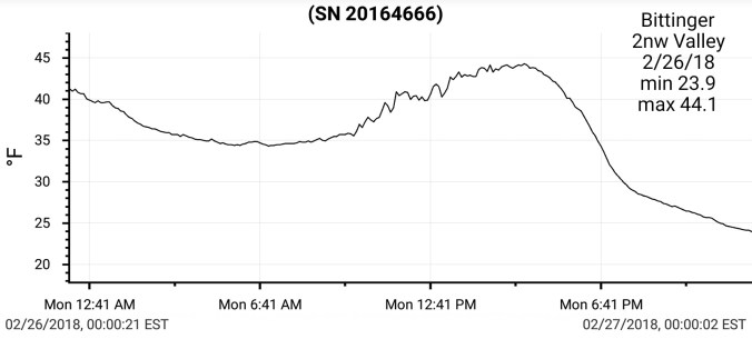
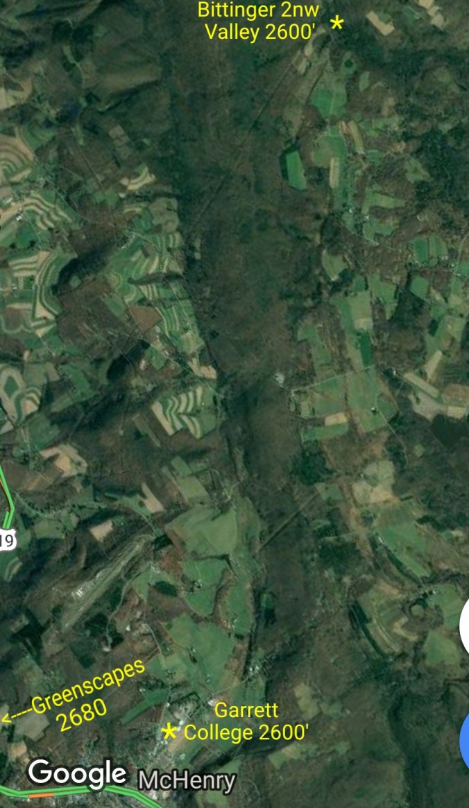
Bittinger 2nw Valley experimental spot2018-02-20-19-27-37

Other pics on the day


Temps at Cabin Mt, (will add Bittinger 2nw Valley) and National temp profile this afternoon, and in closer view. This will not pick up on the valley/high ground difference.2018-02-20-09-58-20


The Big Picture… Our current mild overall pattern shows signs of a breakdown late month, and more so take affect into March. There is some contradictory factors. The cooling off the west coast may help a negative PNA hold and prevent the severe cold from returning this wintet, but allow a pattern to go back into a consistent cold period week 1-3 in March. Lots of details to be worked out and will reveal themselves in time. As of now, plenty of hope for a wintry stretch yet.