Feb 6. min. max. avg
Bitt 2NW valley 12.0 24.5 18.2
Garrett College 15.4 27.3 21.3
Can-Heights 18.2 25.4 21.8
CRN-Canaan 21.0 30.3 25.7
Cabin Mt 20.1 30.7 25.4
Cabin Mt north 19.9 29.8 24.8
Spruce Knob 19.0 30.2 24.6
Snowshoe/S.C 21.4 31.8 26.6
Can-Valley Floor
Cresaptown 18.7 37.6 28.1
Green Bank Obs. 10.2 34.6 22.4
7Springs 18.5 25.3 21.9
Cloudy, a few widely scattered fine flakes on and off. High elevation fog and rime. This occured in Garrett some above 2700′ and more so in higher Wv ground.
Temps today at Bittinger 2nw Valley, Cabin Mt, and temps nationally this afternoon


Temps to begin February


Pics today at Canaan Heights and Backbone Mt near Tucker High


Pic Below by Vernon Patterson at Canaan, looking towards Timberline Ski Resort . Rimed up trees from the fog. 
New cam located on North Fork Mt. This one looking west towards Allegheny Front, at 6pm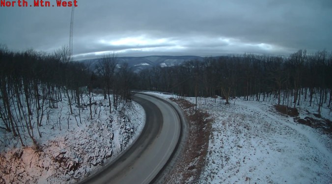
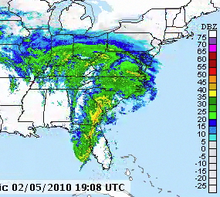
8 years ago today we just finished up with the first of 3 major storms in February 2010. 2-3′ fell in hard hit areas with the storm. Below is a link that will take you to the radar archive of the storm. Simply click mid atlantic region and the dates of Feb 5 2010 and Feb 6 2010. Also some graphics of the storm and pics.
http://www2.mmm.ucar.edu/imagearchive/ this is the radar archive
Below is pics from near Bittinger 2nw. Several from Bittinger 2nw Valley 2/6/ 2010


Some graphics- snowfall from the storm, snowfall depth(which includes snow already on ground) satellite view


Radar snippet as the storm pushed in on the 5th