


Feb 15. min. max. avg
Bitt 2NW valley 52.9 61.0 56.9
Garrett College 54.3 61.0 57.7
Can-Heights 50.6 57.9 54.2
CRN-Canaan 52.7 59.8 56.2
Cabin Mt 47.7 54.7 51.2
Cabin Mt north 49.1 56.7 52.9
Spruce Knob 46.8 54.9 50.8
Snowshoe/S.C 49.1 55.6 52.3
Can-Valley Floor
Cresaptown 44.3 75.0 59.7
Green Bank Obs 50.4 67.4 58.9
7Springs 52.2 59.6 55.8
Overcast, showers, breezy….spotty patches of snow is all thats left aside drifts… This will be my first 24 hour midnight to midnight period without temps falling under 40 since Nov 5. Over 100 days.
Temps at Cabin Mt 4350, and Bittinger 2nw Valley and experimental spot through 1st half of the day. As well as national temp profile this afternoon


First half of February in the books. Bittinger 2nw Valley numbers, Max vs Avg, Min vs Avg, Overall Avg vs Avg


Year to date Avg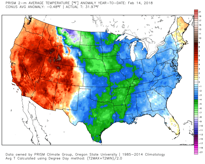
7:30 radar
Yough lake today off Social Media
Model outlook on rainfall amounts till Saturday a.m hours. The tail end of this ends as snow. Then model outlook for snowfall through Sunday with brunt being late Saturday, through wee a.m hours of Sunday
12z ecmwf operational and 18z gfs operational


Possible tornado tonight in Uniontown, Pa. Photos by Stacy Stallard, off social media.


Video of possible tornado damage. Video is from morning of 16th but posting here
https://m.facebook.com/story.php?story_fbid=1862115313822607&id=227009963999825
Also the initial storm report. Nws will confirm the storm today.


