


Feb 20. min. max. avg
Bitt 2NW valley 32.9 70.9 51.9
Garrett College 54.1 73.6 63.8
Can-Heights 47.9 69.2 58.5
CRN-Canaan 47.8 69.8 58.8
Cabin Mt 50.4 66.4 58.4
Cabin Mt north 49.6 69.1 59.3
Spruce Knob 45.7 64.2 54.9
Snowshoe/S.C 48.9 63.0 56.0
Can-Valley Floor
Cresaptown 38.9 85.1* 62.0
Green Bank Obs 37.0 71.5 54.2
7Springs 55.2 73.9 64.6
A wide range of temps overnight into the morning…high ground held 50s, valleys held 30s until predawn hours. This before breezes kicked in, mixed out the cold and temps off to the races in the record max department for the date.
Temps at Cabin Mt 4350 today(will add Bittinger 2nw Valley tomorrow) and temp profile nationally


So, why did valleys still retain a snowcover this morning? Look no further than the mega temp differenes from low areas to high


Few pics today


The big picture, and the Euro ensembles look out 7 to 15 days showing a reversal back to winter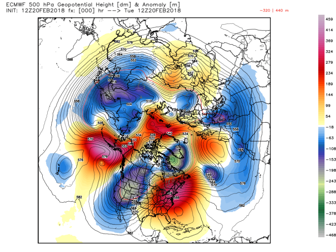


GFS Ensembes
Nitpicking the near term. Upcoming Thursday a high north will be driving colder air into Garrett. The 3km nam usually excels at this setup and has company in other models. The 3km nam is a touch colder than other modeling, enough so, that portions of Garrett and points north along the ridges have the potential to see a little freezing rain. The temp gradient in this setup, which follows the common boundaries with this scenario are great. Possibly 60-65 Parsons, 55-60 Canaan while low to mid 30s across north Central Garrett and points northeast.


Thats the 3km nam setup, check this out as well, windchills Thursday. Windchills 20-25 Garrett, while spinglike just southwest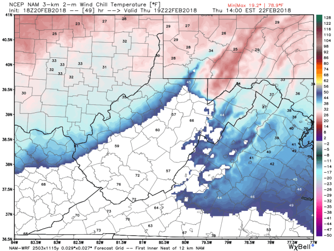
12z euro sees the temp setup, just a touch too warm for freezing, and the Virginia Swiss HD as well sees the same setup and does have spotty freezing(not pictured, gfs is similiar, but 35-38°)


The biggest story as we head into the weekend may be the heavy rains, widespread 2-3″+ amounts showing up on the GFS, Euro from Thursday through Sunday


