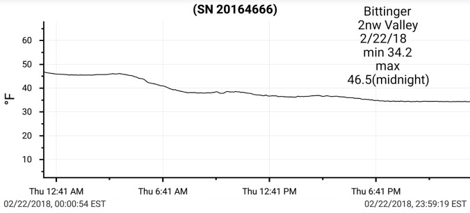
Feb 22 min. max. avg
Bitt 2NW valley 34.2 46.5(mn) 40.3
Garrett College 34.3 47.1 40.7
Can-Heights 48.3 61.3 54.8
CRN-Canaan 42.1 59.1 50.6
Cabin Mt 47.1 55.6 51.3
Cabin Mt north 39.7 54.9 47.3
Spruce Knob 49.6 58.8 54.2
Snowshoe/S.C 50.2 59.7 55.0
Can-Valley Floor
Cresaptown 41.6 56.7 49.2
Green Bank Obs. 48.5 70.2 59.3
7Springs 35.1 45.6 40.3
The temp gradient played out to yesterdays post. The difference from Mt. Storm to Canaan was significant. I will elaborate further below. Drizzle, showers, fog, amd peaks of sun further south in the warm sector. East winds further north and strong east winds. Over 30mph at times at Keysers Ridge. The fog became extremely thick at nightfall. NWS out of Pitt put out a Winter Weather Advisory for Garrett for trace of ice potential. Will elaborate more on this below also.
Temps today at Bittinger 2nw Valley and Cabin Mt 4350 and national profile with a closer look this afternoon..with windchill. Cold raw vs springlike
More on this gradient. Using Bittinger 2nw Valley, Mt. Storm, Canaan Heights. I will add Savage Mt data later when it is sent to me.. comparing the data..
snippets today
From a post I made on facebook in regard to NWS forecast for Garrett…and their updated Winter Weather Advisory tonight
“Winter Weather Advisory for Garrett… least they see its colder than 40s, now to overkill…
Up until hour or so ago. NWS had no temps to fall below 36°. Yesterday none below 40°, day before forecast low was low 40s for tonight. Just like these setups repeat themselves, these types of forecast do as well. I’m no rocket scientist and have only posted what the models put out as it fits the climatology of the area in this setup. I beat the horse to death all week, I do not understand what they were seeing or looking at. Most all model output showed what climatologically occurs for the past several days. I mentioned 3 days ago in a post, NWS was way to warm for Thursday into Friday and would not adjust until the day of…not to make myself sound smart, I’m just use to the same repeated common error I’ve counted hundreds of times by them in the setup. Its a bias in the model they use, its not 2.5km x 2.5km like suggested. Way less. It will not pick up on a gradient and blends it out. It will also kick the cold out to fast.
So just now they issue a Winter Weather Advisory which is really overkill and the coverage of areas listed of possible ice is as well…BUT, at least they again, came around to recognize this. This isn’t so much criticism, or nitpicking, it’s pointing out a common bias they’ve had, and being a small populated area, its not on the front burner for them.
Winter Weather Advisory and forecast from 4 hours ago to now”
Temp gradient modeled through midday tomorrow. After that the cold areas should get a mild surge except low elevations LaVale to Cumberland. Pictured below Super Swiss HD, 3km Nam, 12z ECMWF.


