


Feb 25. min. max. avg
Bitt 2NW valley 39.4 54.0 46.7
Garrett College 39.7 54.3 47.0
Can-Heights 38.8 54.9 46.8
CRN-Canaan 41.2 56.3 48.7
Cabin Mt 36.5 53.4 45.0
Cabin Mt north 37.6 54.5 46.0
Spruce Knob 36.3 51.6 43.9
Snowshoe/S.C 37.6 52.9 45.2
Can-Valley Floor
Cresaptown 45.9 57.8 51.8
Green Bank Obs 46.9 57.7 52.3
7Springs 41.5 55.0 48.2
Heavy rain predawn, to showers and later on just overcast. Temp gradient departed this a.m across Garrett around mid morning. (8-10am). A NW flow behind the cold front late morning allowed for some slightly cooler, drier air to filter in.
Temps today at Bittinger 2nw Valley and Cabin Mt…also national temp profile morning, midday, afternoon … temps through the evening. Will post Bittinger 2nw Valley complete later on


Past 2 day rainfall at Bittinger 2nw Valley 1.7″ +/-
Radar from yesterday afternoon through this a.m
This has caused small streams to run out of bankfull and higher rivers. No extreme flooding. The ground is about as saturated as it can get.


rainfall at Grantsville and Davis for the past week


Precip totals Grantsville and Davis for the month


Observed precip past 1 day , past 7 days


Co-ops precip totals so far this month. Many in record level precip amounts


snippets from this mornings temps


Bittinger 2nw Valley and Canaan Heights overnight into a.m.
Also just to note, since Nov 5, only one day has failed to fall below 40° at Bittinger 2nw Valley. 
Big Picture.. 500 mb anomaly at present to day 10. The blocking becomes more favorably positioned with time. As of current, not ideal for next weekend. Upper pattern however does look better however than operational models are showing at the surface. Needs watched. 
Teleconnections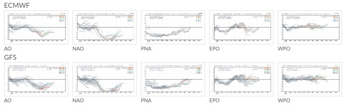
Ensemble members as far as snowfall off the 12zecmwf and gfs next 2 weeks

Short term temps off the 3km nam. Which has its biases. 1 is it will go extreme on low elevation valleys mins…but for our purpose, we aren’t worried about that. Near term, high Wv ground above 4000′ may see a trace of rime in the morning, or a fine flake. Temps 29-32. Monday night, Snowshoe may have some snow making opportunity. Not sure further north. 
Aerial video today by Issac Branch at Canaan, Sand Run Lake
https://www.facebook.com/groups/57963613064/permalink/10157225927223065/
