Feb 27. min. max. avg
Bitt 2NW valley 19.1 51.1 35.1
Garrett College 24.5 54.6 39.5
Can-Heights 19.6 50.1 34.8
CRN-Canaan 24.0 52.6 38.3
Cabin Mt 24.3 48.6 36.4
Cabin Mt north 27.1 49.8 38.5
Spruce Knob 25.0 47.1 36.0
Snowshoe/S.C 27.5 47.1 37.3
Can-Valley Floor
Cresaptown 25.0 62.4 43.7
Green Bank Obs 16.8 54.1 35.4
7Springs 32.4 53.8 43.1
Clear, frosty start, blue skies for most of the day until a few high wispy clouds rolled in.
Temps at Bittinger 2nw Valley and Cabin Mt 4350 today as well as the national temp profile this afternoon. Things got mild after cold start. Air remained very dry


Cold morning allowed for snowmaking at Snowshoe. Only resort in the area on the make.

Thursday into Friday. Comparing the 12Z ECMWF and 18z GFS. Noticeable differences. The 18z closes off the low top to bottom in closer to the coast, and therefore its slower to move out and precipitation, which will be snow will linger longer. The 12z Euro isn’t bad, but its more progressive and slower to close off the low and its further out to sea, and allowed to escape a tad quicker. Not huge differences, and doesn’t necessarily mean less impactful, it would shorten duration of impact. These details will continue to trend, and forecast tweaked in the coming days.
Whats it look like now.
The 12z ECMWF- Precip Type/Kuchera Snowfall amounts/Wind Gust/Temps
Rain to snow overnight Thursday, and continuing through Friday afternoon before ending in the evening. Snowfall amounts 4-8″ (leaning low) , winds 30-50mph for most, 50-70+mph across the Sods, Plains, to Spruce Mountain, temps falling into the 20s predawn Friday and holding.
Low Positions, Gfs closed in close, Ecmwf a wide variety of members off the coast further. So, does it close off in close? At all? How fast does it diddy bop around before escaping? This has room to become more impressive, or less yet with 2 days to go. GFS looks best at the moment.


GFS at 18z
Precip- rain to snow Thursday night, continuing in and through Friday, Friday night and a scattered fashion into Saturday afternoon. Snowfall 4-8 Garrett, Somerset, Fayette, Preston, 6-10 high Wv Mts.
Winds 20-40mph most areas, 35-60mph Sods, Plains, Spruce Mt.
Temps falling into 20s predawn Friday, hold through Sunday.
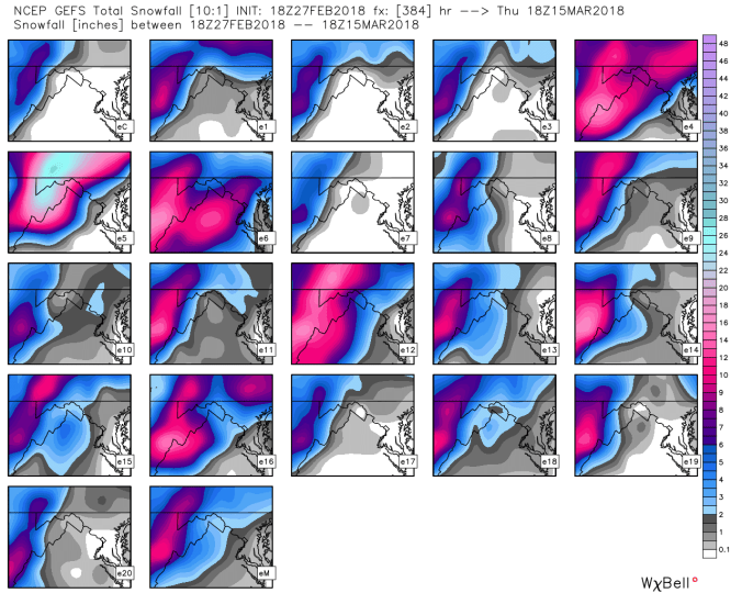
Ensemble members off the 12z ecmwf. This illustrates the wide range of solutions on low placement of the Euro. As the GFS members are more grouped together.
12z ECMWF ensembles
18z GFS ensembles, if you look at the GFS solutions above, shows very clearly why its more robust on snow.