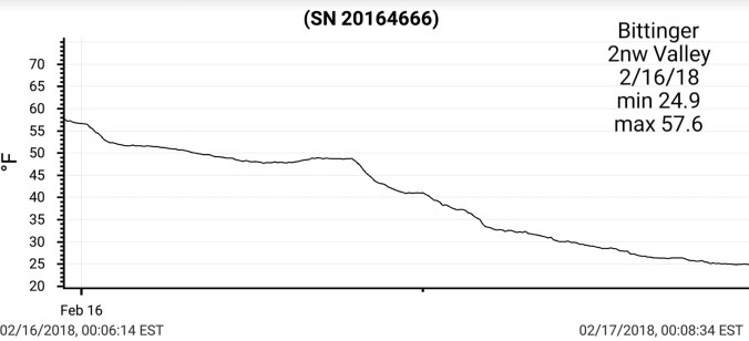
Feb 18.               min.            max.         avg

Bitt 2NW valley  23.4         34.8         29.1

Garrett College   27.9         37.5         32.7

Can-Heights        24.5         35.0         29.8

CRN-Canaan       25.8         38.3         32.1

Cabin Mt             21.7         33.8         27.8

Cabin Mt north  23.0.        34.3        28.6

Spruce Knob      20.7          32.4       26.6

Snowshoe/S.C.   21.9          33.4       27.7

Can-Valley Floor

Cresaptown        28.4          50.7       39.5

Green Bank Obs. 26.4        45.2        35.8

7Springs               28.9         33.7       31.3

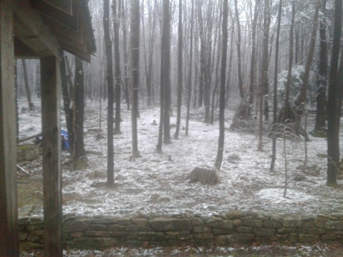
Cloudy morning, skies breaking midday.

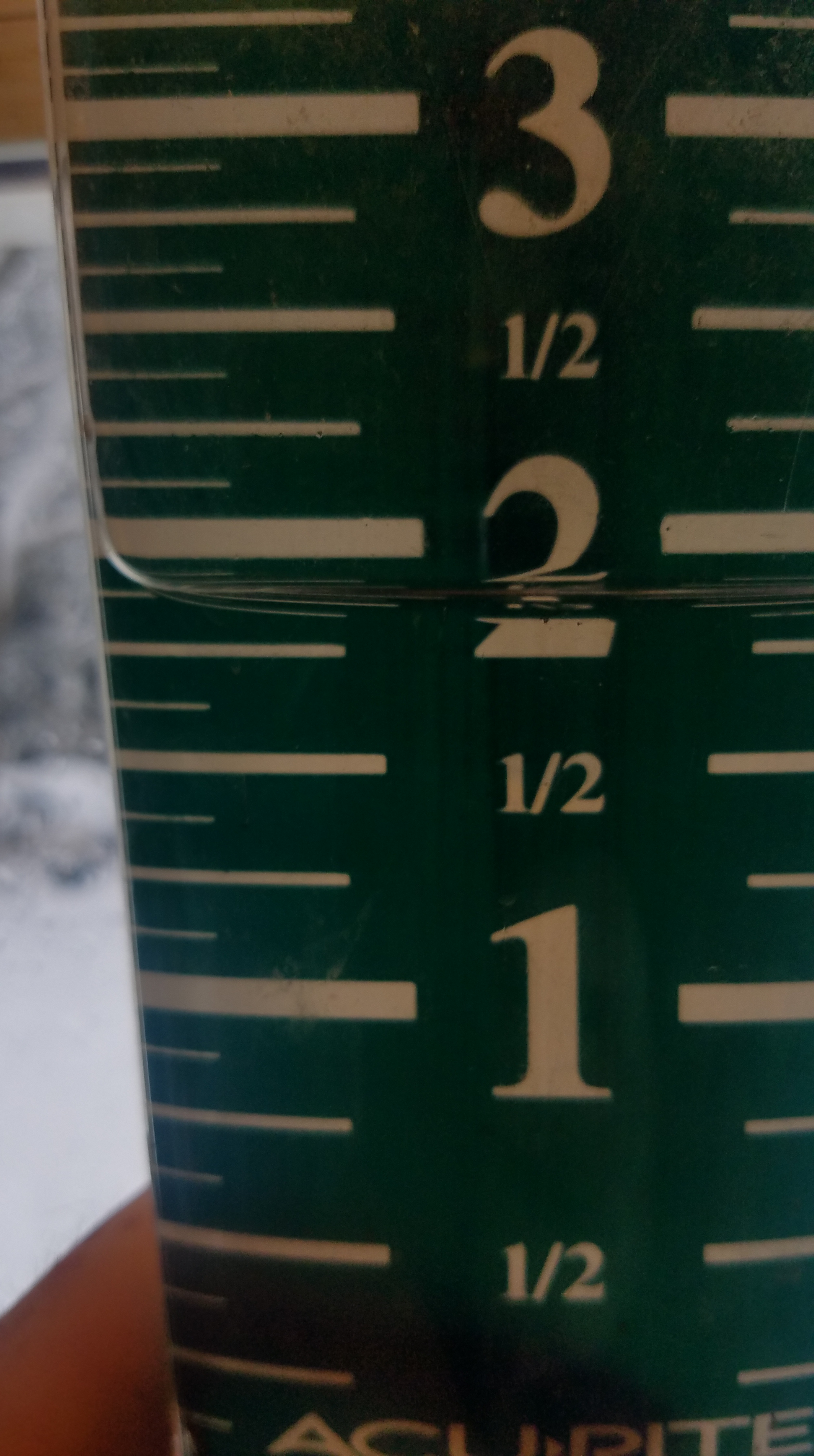
Overnight since 10pm boardsweep,  1.2″ of snowfall at Bittinger 2nw Valley for a storm total of 6.3″ and 7am depth of 5.7″  – season total at 89.8″


Canaan Heights picked up .8″ overnight, for a  4.2″ storm total.  -season total of 101.2″ to date

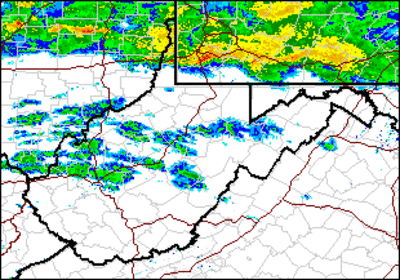
Storm snowfall analysis-FB_IMG_1518980771803

Temps at Bittinger 2nw Valley 2018-02-20-19-19-40

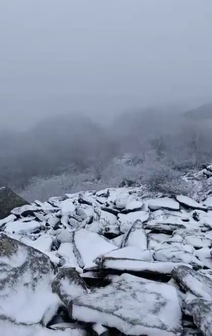
Pics below by Jeremy Cutlip along Highland Scenic Highway area


Pics below by ” Moments by Steffi Hone” looking towards Judy Gap, Germany Valley, North Fork Mt.


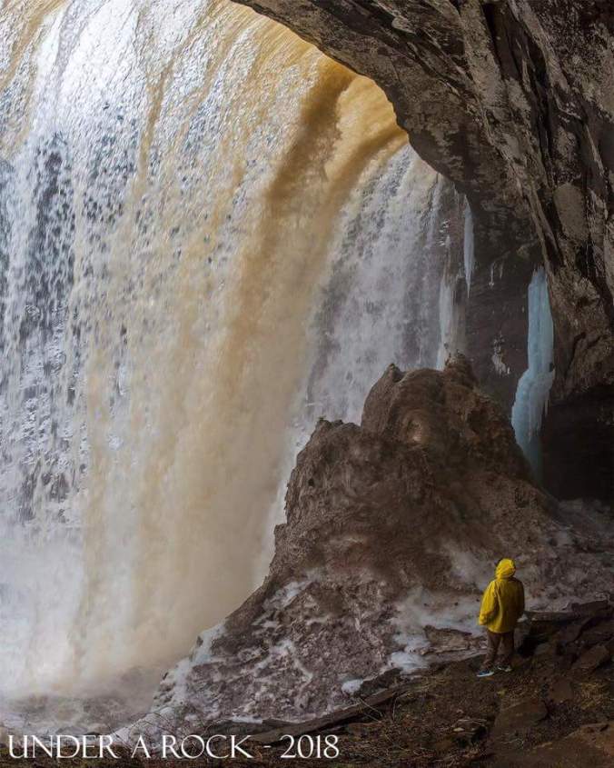
Pic by Vernon Patterson at Pendleton Falls , in Blackwater Falls state parkFB_IMG_1518992063046

Pics below by Renee Morris at Canaan


Pics below by Peggy Thorne-Church from the air above the Canaan area/Mt. Storm, Sods


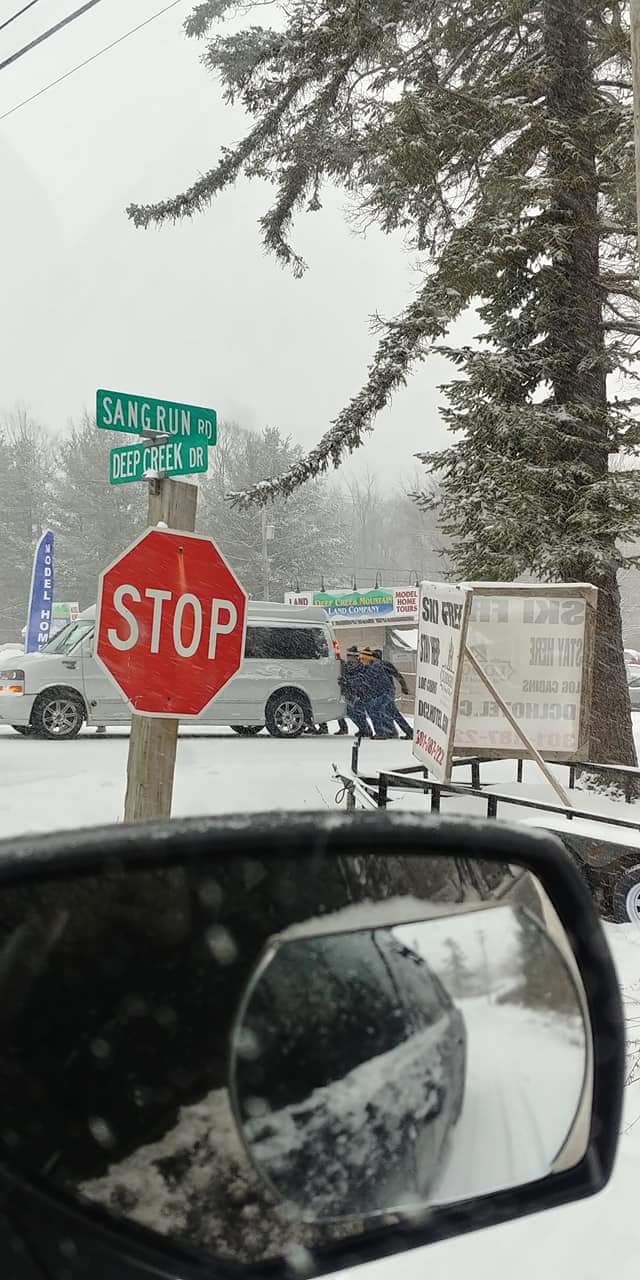
Other webcam pics today… first 3 Snowshoe, 2 at Canaan, 2 at Wisp, 1 at North Fork Mt, 1 at Keysers Ridge


Snowfall on the season


Feb 17.                   min.         max.      avg

Bitt 2NW valley    18.1         31.2       24.6

Garrett College     21.3         31.3       26.3

Can-Heights          20.4         32.5       26.5

CRN-Canaan          21.9        33.3       27.6

Cabin Mt                19.4        31.1       25.2

Cabin Mt north     19.9       31.8        25.8

Spruce Knob          19.4      31.8        25.6

Snowshoe/S.C        21.4      33.4        27.4

Can-Valley Floor

Cresaptown          24.1       38.3        31.2

Green Bank Obs  24.6       38.6        31.6

7Springs               22.0        32.4       27.1

Breaks in clouds for a decent sunrise. Trees coated with rime…then the lull before the snow thump. Mid afternoon snow picked up and came down a 1-2″ per hour for a few hours. Causing very poor road conditions. Precip broke out earlier further south with snow, sleet, freezing rain. Further north as the snow lightened, around 9-10pm a light period of freezing drizzle occured before another round of snow overnight.

Temps today Bittinger 2nw Valley(through 4:44pm)  Cabin Mt 4350, and National temp profile this afternoon


By 10p.m at Bittinger 2nw Valley I had recorded 5.1″ of snow. – 88.6″ on the season


Pics on the day


Pic below by Julie Hartman, Mchenry MdFB_IMG_1518975600550

Pics below by Jeremy Cutlip, Mt.Grove Va


Timelapse gets covered at Canaan

https://www.fsvisimages.com/timelapse.aspx?site=doso1

Image by Tom Hamilton (video snippet) before the snow came today on Spruce Knob. Rime/Fog

Screenshot_20180218-180050

Radar snippets during the snow


Feb 16.                 min.           max.        avg

Bitt 2NW valley  24.9          57.6        41.2

Garrett College   24.6          57.6         41.1

Can-Heights        22.7          57.8         40.2

CRN-Canaan       24.8          60.0         42.4

Cabin Mt             20.8           55.0        37.9

Cabin Mt north 21.2           56.5        38.8

Spruce Knob      22.6          53.8        38.2

Snowshoe/S.C    24.4          54.7        39.5

Can-Valley Floor

Cresaptown        33.8         65.9        49.8

Green Bank Obs 32.4        64.7        48.5

7Springs              23.7         57.9        40.8

A LOT to go over for today. From heavy rain, to a afternoon change to snow, fog, falling temps.  Rainfall amounts in the 1-3″ range with the system across the area, isolated higher amounts. Over 4″ around Terra Alta.  Rain began to taper, mix with snow midday and changeover early afternoon.

Bitt 2NW valley snowfall – .1″ on the day, partially melted. 83.5″ on the season

Canaaan Heights .8″ with 97.0″ on the season

Will do this a little different today. Starting off with National temp profile last night through 5pm. Cabin Mt 4350 and will add Bittinger 2nw Valley later.


2018-02-24-14-04-39.jpg

Bittinger 2nw Valley at near 2″ of rain(pulled it before froze) 20180218_083133.jpg

Radar loop

https://www.woweather.com/cgi-app/radar?CONT=usus&CREG=UWV&LTYP=tag&LANG=us&STRUCTUR=_&W=0&L=0&SLP=0&ROAD=0&CITY=&LF=0&SUM=0&LOOP=1 2318


Pics by Jeremy Brenneman, Cassleman Valley south of Grantsville and Mosser Rd east of Mchenry. Water was still on the rise at the time of the pics and Md 495 was closed shortly after


Pics by Erik Peterson in Oakland today


Pic by Garrett County Public Safety 2018-02-16-17-48-04.jpg

Garrett County “The Republican” story


Some water data, that I may update again further below


Pics today at resorts, webcams, Snowshoe, Canaan, North Fork Mt, Deep Creek, Keysers Ridge


Pic below by Bill Buckel, at Bittinger 2nwResized_20180216_171655_6915

Pic below by Renee Morris this afternoon at Timberline at CanaanFB_IMG_1518820975497

Social media pic at DavisScreenshot_20180216-170510

Snowshoes changeoverScreenshot_20180216-170710

Muddy Creek Falls, posted by Swallow Falls area hiking Facebook page

10000000_582307652129855_4292197690634141696_n_1

Ohiopyle today, maxed out at 26500cfsScreenshot_20180216-210023

Radar images of the system


Storm was confirmed a ef-1 in Uniontown last night by the NWS, pics by Sam Hall WTAE


Feb 15.                  min.         max.         avg

Bitt 2NW valley 52.9        61.0          56.9

Garrett College   54.3        61.0           57.7

Can-Heights        50.6         57.9          54.2

CRN-Canaan       52.7         59.8          56.2

Cabin Mt              47.7         54.7          51.2

Cabin Mt north  49.1         56.7          52.9

Spruce Knob       46.8         54.9         50.8

Snowshoe/S.C      49.1        55.6         52.3

Can-Valley Floor

Cresaptown          44.3         75.0        59.7

Green Bank Obs   50.4         67.4       58.9

7Springs                52.2         59.6        55.8

Overcast, showers, breezy….spotty patches of snow is all thats left aside drifts… This will be my first 24 hour midnight to midnight period without temps falling under 40 since Nov 5. Over 100 days.

Temps at Cabin Mt 4350, and Bittinger 2nw Valley and experimental spot through 1st half of the day. As well as national temp profile this afternoon


First half of February in the books. Bittinger 2nw Valley numbers,  Max vs Avg, Min vs Avg, Overall Avg vs Avg

Year to date Avgconus_ytd_t2avg_anom_2018

7:30 radarScreenshot_20180215-194030

Yough lake today off Social MediaScreenshot_20180215-152007

Model outlook on rainfall amounts till Saturday a.m hours. The tail end of this ends as snow. Then model outlook for snowfall through Sunday with brunt being late Saturday, through wee a.m hours of Sunday

12z ecmwf operational and 18z gfs operational


Possible tornado tonight in Uniontown, Pa. Photos by Stacy Stallard, off social media.

Video of possible tornado damage. Video is from morning of 16th but posting here

https://m.facebook.com/story.php?story_fbid=1862115313822607&id=227009963999825

Also the initial storm report. Nws will confirm the storm today.


Feb 14.                    min.        max.       avg

Bitt 2NW valley    31.3        54.3       42.8

Garrett College      32.6       55.0       43.8

Can-Heights           37.3        52.9       45.1

CRN-Canaan          31.8        53.3       42.5

Cabin Mt                36.3        50.4       43.3

Cabin Mt north    36.3         51.4      43.8

Spruce Knob        33.3          47.8     40.5

Snowshoe/S.C      37.8          50.4     44.1

Can-Valley Floor

Cresaptown          30.0         50.9      44.1

Green Bank Obs  27.5          54.5     41.0

7Springs                33.3          55.9     44.6

Cloudy,  temps rising before daybreak. Fog across high wv ground. Scattered showers , drizzle and times of nothing. Winds picked up overnight into today.

Temps at Cabin Mt 4350 through 6:30pm and Bitt 2NW valley only through 11am, will update that soon. Also national temp profile this afternoon


Final Bittinger 2nw Valley numbers


7pm radarScreenshot_20180214-185753.jpg

Great Lakes IceFB_IMG_1519089635290


Feb 13.                   min.       max.        avg

Bitt 2NW valley   12.1        34.1        23.1

Garrett College    17.3       37.0        27.1

Can-Heights         19.5        41.0        30.2

CRN-Canaan         19.0       39.5        29.2

Cabin Mt              19.9         36.9       28.4

Cabin Mt north   18.1         37.2      27.7

Spruce Knob        20.8         33.3      27.0

Snowshoe/S.C       22.8        37.8      30.2

Can-Valley Floor

Cresaptown          19.1         45.9      32.4

Green Bank Obs  19.6        34.2       26.9

7Springs                18.0        38.4       28.2

Clear, calm cold start. Easterly flow kicking in, and cloud cover in the afternoon. Fog across Wv mts in afternon. Some drizzle, patchy freezing. Some light drizzle Garrett after dark. Temps 31 at that time and light freezing. Temps expected to rise from time of this posting.

Temps at Bittinger 2nw Valley, Bittinger 2nw Valley experimental spot, Cabin Mt 4350, and national temp profile this afternoon

Feb 12.               min.          max.         avg

Bitt 2NW valley 19.9         38.8        29.3

Garrett College  22.5         40.7        31.6

Can-Heights      20.9          39.5        30.2

CRN-Canaan     22.2.         38.7        30.4

Cabin Mt            19.4        37.2        28.3

Cabin Mt north 20.5        37.2       28.9

Spruce Knob      18.5       41.2       29.9

Snowshoe/S.C    20.5       43.3       31.8

Can-Valley Floor

Cresaptown        28.1       49.7      38.8

Green Bank Obs 25.2       48.2      36.7

7Springs               24.2       34.6     29.4

Light freezing drizzle, fog overnight to a brief period of snow around dawn and shortly after. Skies then broke and partially cleared midday on.

Snowfall- Bittinger 2nw Valley picked up .3″ this morning. Season total 83.4″. More in the way of accumulation west of the mts. 2018-02-12-11-28-56

Temps today at Bittinger 2nw Valley, Cabin Mt 4350 and national temp profile this afternoon

Final Bittinger 2nw Valley temps2018-02-13-21-38-18.jpg


Feb 11.                 min.         max.      avg

Bitt 2NW valley  33.5         53.1       43.3

Garrett College   41.0         56.8       48.9

Can-Heights        40.8         52.8       46.8

CRN-Canaan       39.3         54.8       47.1

Cabin Mt             38.7         50.4       44.6

Cabin Mt north 38.3         52.0       45.2

Spruce Knob      42.1         48.9      45.5

Snowshoe/S.C      43.5        50.4      47.0

Can-Valley Floor

Cresaptown          35.6         50.4      43.0

Green Bank Obs   33.4         54.5      43.9

7Springs                 34.7         57.7      46.2

cloudy, rainy, calm through early afternoon, skies broke, light breezes kicked in. Valleys holding colder through temp recording times. But as wind kicked up after dark, I think we’ll see a spike in numbers before colder air returns overnight. Minor creek flooding from snowmelt, and rainfall totals .5 to 1.5 north, with isolated higher south.

Temps at Bittinger 2nw Valley, experimental spot and Cabin Mt 4350. As well as the look at temps on temps national map this afternoon


Final numbers at Bittinger 2nw Valley and experimental spot. Good example of why those sheltered high elevation low spots hold onto snow longest.


Pic by Vernon Patterson at Blackwater Falls todayFB_IMG_1518400510397

Pics by Rosanna Springston at Falls of Hills Creek and Cranberry area…

Pics by Jeremy Cutlip around Bath/Pocahontas Counties


Pic by Ryan Maurer posted on West Virginia Waterfall facebook page. Pic at lower falls at Falls of Hills CreekFB_IMG_1518490969803


Some river data in the region, and radar estimated rain totals.


Radar snippets today


Past 90 day temps since mid Novemberncep_cfsv2_360_t2anom_usa


Feb 10.                     min.       max.       avg

Bitt 2NW valley   22.3         40.2        31.2

Garrett College    34.2         48.9        41.6

Can-Heights         35.8         50.0        42.9

CRN-Canaan        32.9         47.0       39.9

Cabin Mt              34.9         46.4       40.7

Cabin Mt north   34.7         48.2      41.5

Spruce Knob       31.3          44.1     37.7

Snowshoe/S.C      32.0         44.8     38.4

Can-Valley Floor

Cresaptown        24.8         43.0      33.8

Green Bank Obs 23.7       39.0       31.4

7Springs               36.5       50.9       43.7

Overcast, calm day. Light breezes in some areas. Light rain late day. More in the way of rain in the southern Alleghenies to central Alleghenies. The day had a wide variance in temps. Sheltered valleys much cooler than high ground. Will illustrate that with examples below.

Lets look at Bittinger 2nw Valley, 2600′. A sheltered valley area, vs a hilltop of 2650′ in Mchenry. Using that site as an example due to the fact it has data. I could have used a site 1/2 mile away had it existed. At any rate, here is the overnight into the morning.


You can see how much colder the sheltered valley ran vs the hilltop. Thats not all that untypical at night. How about the day? With a snowcover, calm winds in the sheltered valley, the daytimes can have a great difference also, and thats what occured today. The sheltered valley did not see 40° as the hilltop hasn’t been below since sunrise.


I also put out an experimental location within the sheltered valley and it topped out at 37° during the daylight hours. Being more sheltered it did not get as cold as the regular recording site, but held colder today. 34° at 4:09pm2018-02-10-17-04-01

Temps today at Bittinger 2nw Valley, Cabin Mt 4350 and national temp profile(which won’t touch the mini microclimates)


8pm radarScreenshot_20180210-200132


Feb 9.                  min.           max.       avg

Bitt 2NW valley  8.4          36.9        23.6

Garrett College  11.6         44.1        27.8

Can-Heights        15.7        42.6        29.1

CRN-Canaan        18.2       43.8        31.0

Cabin Mt               15.1       39.6       27.3

Cabin Mt north    15.6       41.5       28.5

Spruce Knob         14.5       37.2      25.9

Snowshoe/S.C        17.6       36.7      27.2

Can-Valley Floor

Cresaptown            18.5      41.2      29.6

Green Bank Obs    12.0       40.9     26.5

7Springs                  17.1       39.2     28.1

High overcast, lower at times. Dimmed sun. Easterly flow. Temp setup similiar to the ice event 2 days ago. Will post on that below

Temps at Bittinger 2nw Valley, Cabin Mt 4350 and national temp this afternoon

Pics below by Eric Furr from Bartow at sunrise this a.m