March 31.           min.        max.        avg

Bitt 2nw Valley 28.8       55.0         41.9

Garrett College station issues

Can-Heights       27.3       52.4       39.8

CRN-Canaan      28.3       53.4       40.8

Cabin Mt            23.7       49.3       36.5

Cabin Mt north no data

Spruce Knob no data

Snowshoe/S.C   23.5        46.9       35.2
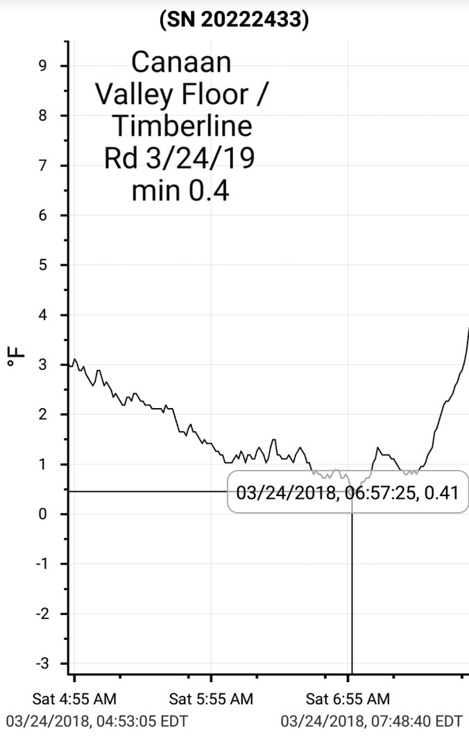
Can-Valley Floor

Cresaptown        28.6          67.8       48.0

Green Bank Obs  25.2         57.3      41.2

7Springs                29.9         54.8      42.3

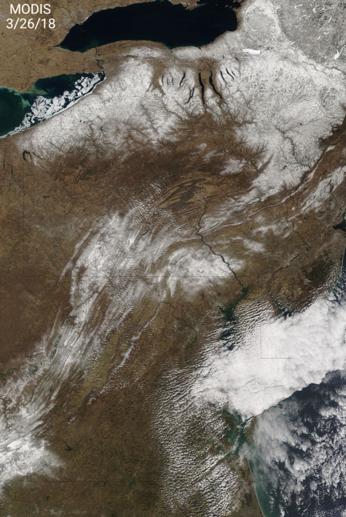
Clouds early, giving way to a mostly sunny day with a few mid level clouds late. Some fog across high Wv ground early with some rime also up high.

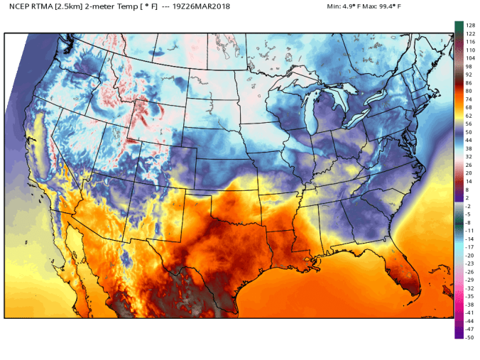
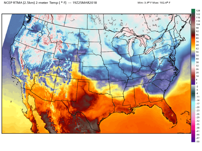
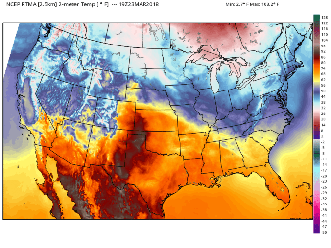
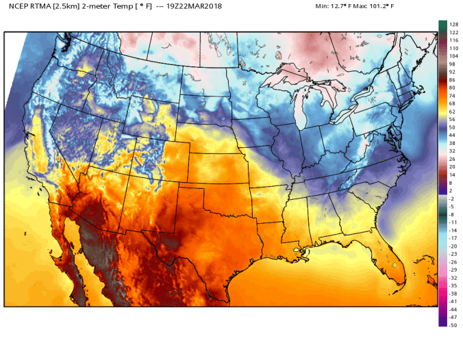
National temp profile todayrtma_t2m_conus2

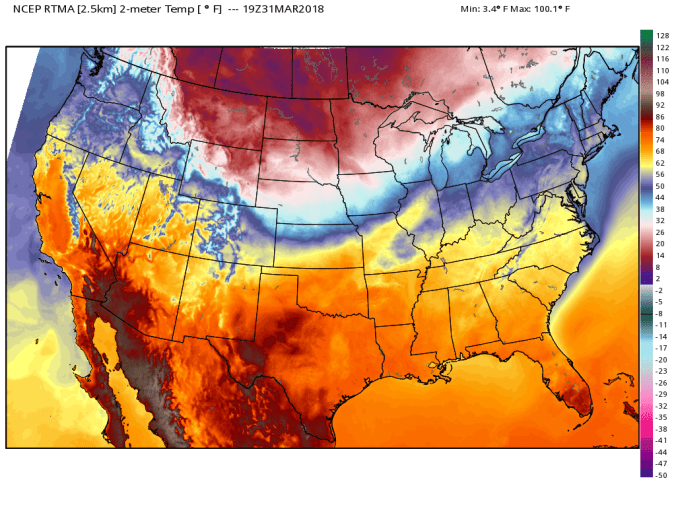
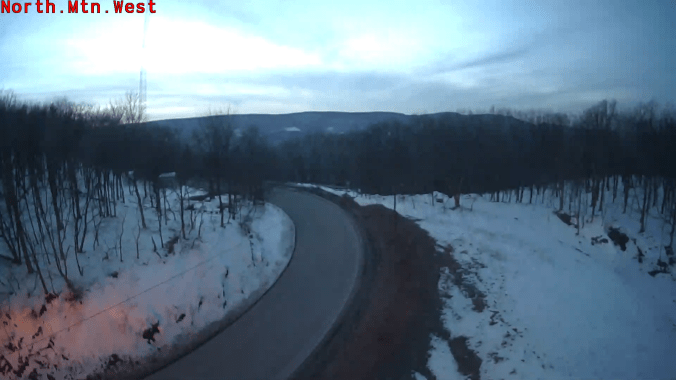
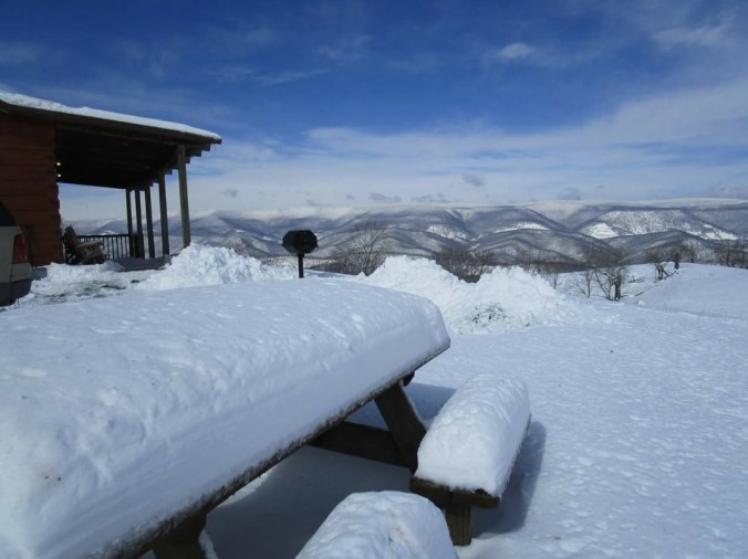
Daily snippets. Snowshoe and 7Springs having a great spring/Easter ski weekend
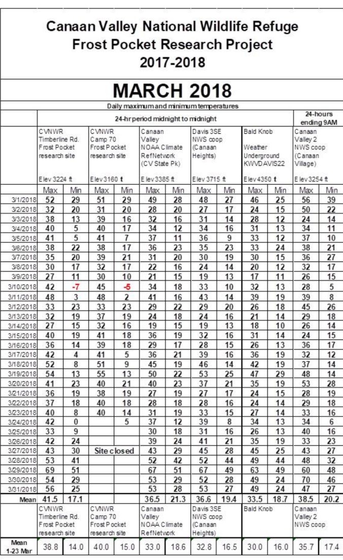


March Summary

March averaged colder than February. Also to note, this does not apply to most areas, since November 5th, at Bittinger 2nw Valley site, only 1 time in the 24 hour period midnight to midnight have temps failed to fall below 40°.


Data put together by Dave Lesher at CanaanScreenshot_20180401-210823


March 30.                min.        max.        avg

Bitt 2NW valley     30.9         53.7        42.3

Garrett College      31.5         55.2        43.3

Can-Heights           27.7         51.6        39.7

CRN-Canaan          28.5         53.4       40.9

Cabin Mt               24.1          48.9       36.5

Cabin Mt north no data

Spruce Knob no data

Snowshoe/S.C       23.7          49.3      36.5

Can-Valley Floor

Cresaptown         36.9          64.1      50.5

Green Bank Obs  27.2         55.6       41.4

7Springs               31.2          56.7       44.0

Rain, drizzle fog early, to scattered drizzle and then some light scattered wet snow. Coating high Wv mts. Just in the air elsewhere. Falling temps through the day after a mild, windy, wet overnight that ate away majority of the remaining snow, except drifts and piles.

Temp profile this afternoon nationally and a closer look midday with a large contrast from the Alleghenies to lowlands east


Keysers Ridge with wet flakes about this afternoon

Daily snippet from Timberline this afternoonScreenshot_20180330-181514

Photos from Sarah Bailey looking across the valley towards Cabin Mt with and without snow showers this afternoon


Pic by TipTop Thomas and stats off Blackwater today running over 2000 cfs awhile


Bittinger 2nw Valley month to date, running colder than the month of Feb2018-03-30-17-00-36


March 29.               min.         max.      avg

Bitt 2NW valley    38.2         68.2       53.2

Garrett College     51.7         69.2       60.4

Can-Heights           48.7        65.6       57.2

CRN-Canaan         51.0        67.2       59.1

Cabin Mt               48.9         63.1       56.0

Cabin Mt north no data

Spruce Knob no data

Snowshoe/S.C      48.7         62.4      55.5

Can-Valley Floor

Cresaptown           46.8          69.5      58.1

Green Bank Obs   43.3         72.6       57.9

7Springs                  49.3        66.3      57.8

Some rain early, then a mostly cloudy sky with breaks of sun in the afternoon, much milder.

Temps at Bittinger 2nw Valley and experimental spot as well as national profile. Good illustration last night of cold damp air draining any laying low this morning. Warmest day of the month.


March 28.               min.           max.    avg

Bitt 2NW valley     32.2        48.9       40.5

Garrett College       40.6      53.7       47.2

Can-Heights            43.8        49.9      46.8

CRN-Canaan           42.3         51.6      47.0

Cabin Mt                43.7         49.1      46.4

Cabin Mt north no data

Spruce Knob no data

Snowshoe/S.C          45.5        49.8      47.6

Can-Valley Floor

Cresaptown             39.8      50.7       45.2

Green Bank Obs     33.8      52.7       43.2

7Springs                   40.1     52.6       46.3

Cloud, rainy, some low lying valley fog from snow cover…

Temps today at Bittinger 2nw Valley and experimental “refridgerated” spot and national profile

Rainfall today, from 3/4 to a 1 3/4 range

radar and precip amounts


March 27.            min.          max.       avg

Bitt 2NW valley   28.9        32.5        30.7

Garrett College    29.5       40.1         34.8

Can-Heights         27.7       44.9        36.3

CRN-Canaan        29.2       42.5        35.9

Cabin Mt              25.2        44.6       34.9

Cabin Mt north no data

Spruce Knob no data

Snowshoe/S.C        24.8          46.8      35.8

Can-Valley Floor

Cresaptown            35.8         41.6       38.7

Green Bank Obs     29.6         35.9       32.8

7Springs                   30.8         39.6       35.2

Cloudy, to freezing rain breaking out 8am. Temps at or below freezing most of the day, creeping just above late. At 6:30 Bittinger area still coated in ice, Mchenry had melted off.  .1 to .25 ice in heaviest zones.

Temp profile today.


Bittinger 2nw Valley 4pm


March 26.             min.        max.       avg

Bitt 2NW valley   26.5         41.4       33.9

Garrett College    26.3         42.1       34.2

Can-Heights         22.0          39.1      30.5

CRN-Canaan        24.2          38.9       31.5

Cabin Mt              18.9          35.2       27.0

Cabin Mt north no data

Spruce Knob no data

Snowshoe/S.C        19.6         36.0      27.8

Can-Valley Floor

Cresaptown           23.6       54.5   39.0

Green Bank Obs   27.8         44.4     36.1

7Springs                28.5         41.2     34.8

Another blue sky day, stiff east winds, with some high clouds building late.

Temp profile this afternoonrtma_t2m_conus2

Bittinger 2nw Valley late evening

Satellite view today. Snowcover visible across the Alleghenies..cloudcover in the Delmarva2018-03-26-20-32-09

North Fork Mt 8pmScreenshot_20180326-195908


March 25.               min.         max.     avg

Bitt 2NW valley    17.0         34.5      25.7

Garrett College     18.8         34.0      26.4

Can-Heights           16.6        30.1      23.4

CRN-Canaan          17.6        29.6      23.6

Cabin Mt                 13.3        26.4      19.9

Cabin Mt north no data

Spruce Knob no data

Snowshoe/S.C         20.8        34.5       27.6

Can-Valley Floor

Cresaptown             27.2      48.2      37.6

Green Bank Obs     15.7       40.0     27.9

7Springs                    17.9      35.2     26.5

Clear start to finish……snow showers eastern Pa, Baltimore area.

Temp profile this afternoonrtma_t2m_conus2.png

Deep Creek Lake, Cherry Creek Cove frozen over

Bittinger 2nw Valley this afternoon

Daily snippets

Satellite views this afternoon. Snowcover showing up across mts, and yesterday/last nights snow.

Snow from last night across southern Wv, Va, NC mts. Bluefield in at 17″, Burkes Garden 15″Screenshot_20180325-192328.jpg

Pic by Leanne Gibson in BluefieldScreenshot_20180325-192446


March 24.              min.         max.       avg

Bitt 2NW valley   10.2         40.4        25.3

Garrett College     15.8        40.9        28.4

Can-Heights           9.1          36.9       23.0

CRN-Canaan         11.9         37.1       24.5

Cabin Mt               13.3         34.2       23.8

Cabin Mt north no data

Spruce Knob no data

Snowshoe/S.C.     17.1           33.6       25.3

Can-Valley Floor 0.4

Cresaptown           22.5          52.0      37.2

Green Bank Obs   12.6           41.6      27.1

7Springs                  21.1          39.1     30.1

The Glades             0.2

clear skies, giving away to a high cloud deck later afternoon, evening. Low dew points. Snows remained southern Wv, Ca, NC. Locally snow cover is widely varied, from location to location and slope direction with the late March Sun. Up on Bald and Weiss Knobs, a hefty snowpack exist.  Down low, not much. Redhouse, mostly bare. Bittinger area, still a decent cover with hefty amounts wooded, and north facing slopes. To note, above 4000′ some ice from freezing rain remained since Tuesday.

Temp profile this afternoonrtma_t2m_conus2

Morning min of 0.4 at Canaan Valley Floor station2018-03-24-22-03-14

Min temp 0.2 on The Glades near Bittinger in Garrett County this morning2018-03-25-11-13-57

Radar today, showing the southern Wv, Va, NC snow

Daily snippets


March 23.                min.        max.      avg

Bitt 2NW valley      19.3         37.0      28.1

Garrett College       21.7         35.3      28.5

Can-Heights            14.6          31.5     23.0

CRN-Canaan           19.3         31.4      25.4

Cabin Mt                 14.2         27.1      20.6

Cabin Mt north no data

Spruce Knob no data

Snowshoe/S.C         16.2         27.9     22.0

Can-Valley Floor    8.3          39.6*    23.9

Cresaptown            26.3        52.0      38.7

Green Bank Obs     20.6       40.0       30.3

7Springs                  23.2        34.2       28.7

* possible radiation issue

Clear start, with some clouds building. Some snow showers across high Wv ground and a in parts of Garrett and scattered in Pa. I only had a few stray flurries. Despite late March sun, and temps creeping above freezing, very dry air allowed for the winds to still blow some snow around the entire day.

National Temp profile this afternoonrtma_t2m_conus2.png

Snow showers around Canaan this afternoon

Afternoon, evening still some spots of blowing snow around Bittinger

Daily snippets… Snowshoe today, and a pic from North Fork Mt with a snowshower coming across the Allegheny Front


Radar snippet this afternoon showing the few popup snowshowers…. once again, distance from radars failed to pick up on the few at CanaanScreenshot_20180323-151525.jpg


March 22.              min.         max.       avg

Bitt 2NW valley    17.7        35.0       26.3

Garrett College     18.9        32.8       25.8

Can-Heights          16.8        28.4       22.6

CRN-Canaan         18.2         27.7      22.9

Cabin Mt                14.0         24.4     19.2

Cabin Mt north    no data

Spruce Knob no data

Snowshoe/S.C        14.7       21.9        18.3

Can-Valley Floor   18.2       37.0*       27.6

Cresaptown            25.7      48.0         36.8

Green Bank Obs     22.4      37.9        30.2

7Springs                   20.8      32.4        26.6

Cloudy to start, a few fine stray flakes early. Eventually going to a mix of clouds and sun. Snowfall was only an additional trace overnight. Breezy with minor blowing.

Temp profile this afternoon. The Alleghenies amongst the coldest spots in the nation. rtma_t2m_conus2.png

Satellite view earlier today. snowcover still visible despite some cloud cover


Pic by Germany Valley Overlook Cabins..With their awesome view west of the Allegheny Front. They had measured 15″. Screenshot_20180322-164443

Pics today by Rosanna Springston at Cranberry Glades and Highland Scenic Highway area

Daily snippets

Final snowfall analysis…not perfect, but a good general ideaScreenshot_20180322-201014

Weekend Snow

As of right now, it appears the southern Alleghenies into Va stand highest likelhood to see significant snow from that.gefs_snow_mean_ma_20

Looking back. Temps over the past 90, and 120 days. With the fluctuations og ups n downs, right above average tp slightly below.

The month to date March 2018conus_mtd_t2avg_anom_2018.png