


March 15. min. max. avg
Bitt 2NW valley. 20.5 38.2 29.3
Garrett College 21.6 38.9 30.2
Can-Heights 15.8 33.8 24.8
CRN-Canaan 18.7 35.8 27.3
Cabin Mt 13.6 30.6 22.1
Cabin Mt north no data
Spruce Knob no data
Snowshoe/S.C 14.4 32.7 23.5
Can-Valley Floor 18.8 39.4 29.1
Cresaptown 30.9 51.5 41.1
Green Bank Obs 19.1 43.7 31.4
7Springs 23.7 35.9 29.8
Snow showers, flurries, at varying rates scattered about today intetmixed with some sun. Breezy.
Snowfall- Bittinger 2nw Valley .2″ fluff overnight from 6pm till 7am. Snow ended near midnight. Snow began again this a.m and briefly moderate and flurries lingered through midday. .2″ with this event for new total of .4″. Season to date total 118.6″
Snow at Bittinger 2nw Valley this a.m. Intensity was briefly heavier than this a few times.
Temp profile this afternoon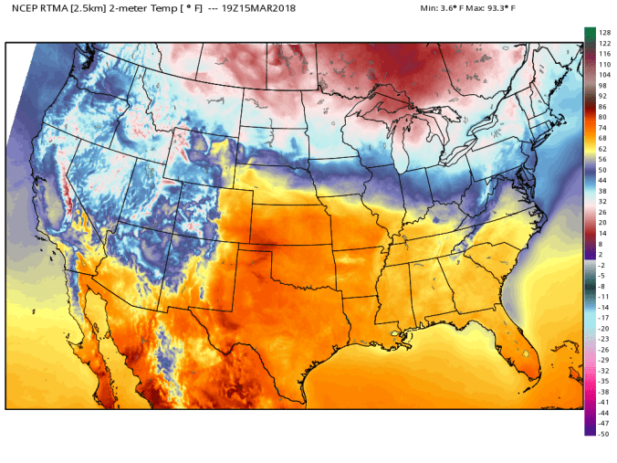
Pic below by Golden Anchor Cabins at Canaan. Beautiful views at the cabins looking towards the snow covered Mt. Porte Crayon
Daily snippets


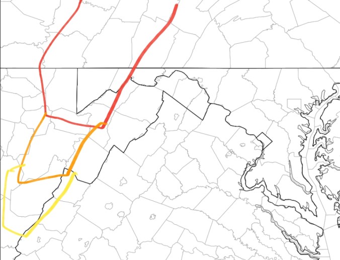
Saturday’s thoughts and the potential storm next week:
Overnight Friday, Saturday a.m, temps will be on the rise. The most noticeable rise will occur across the high ground of the southern Alleghenies.
Breakdown: The yellow zone, especially the high ground will see a temp rise overnight Friday into Saturday a.m, to 33-38° and should equate to any precip being in liquid form. Air aloft here is not conducive for snow. If any freezing were to occur, low lying valleys with the snowpack would be a hold out for that. Even that looks slim.
Orange zone- precip timing will be key. The earlier it arrives, the more likelihood of seeing some freezing rain, especially in the valleys. All areas should come up above freezing by mid morning to midday.
Red zone- Again, precip timing is key. If it arrives fast enough, it will begin as snow/rain mix. Air aloft is borderline cold enough. Any early mixing with temps near 30-33 should briefly transition to a rain, snow and later on primarily snow as cold air aloft bleeds back in. While the air aloft is turning colder, surface temps may rise 33-36 during the main precip. Therefore, I dont see much accumulation of snow. Except if we see some heavier precip rates and the high ground could pick up a inch of wet snow.
After the main precip pulls away, the high ground is left with some fine light snow, freezing drizzle with little to no accumulation of snow. Some brief riming is possible above 2800′ , above 3500 across Wv as colder air filters backk in. Skies should break overnight.
Next Week
Right now, models have trended into a favorable position for a good size snow event for portions of the area. Being 5 days out, this will adjust day by day. A complicated setup once more.
Without going into the teeny tiny details, there is plenty that can change, but this has the looks of a late season special for the Allegheny Front, Mt. Storm, Savage Mt. Some areas that missed out on this past weeks storm, could potentially see their best snow of the season if the modeled track remains similiar to how its presently modeled.
Some model output off the runs today. Modeled 12Z ECMWF for the system at the surface. Pic 1 and 2, and 12Z GFS at the surface in pic 3 and 4. Then the ensemble members for snow amounts off the 12z ECMWF and the Operation run off the model. Lots of support for the storm, track will need honed in as we get closer, to determine how this may play out.


If you have enjoyed the weather updates on facebook, or here on this site, and they have been of benefit to you, feel free to contribute to help offset the cost of my model access and time and effort put into this at
