


March 16. min. max. avg
Bitt 2NW valley 17.5 30.7 24.1
Garrett College 16.9 30.3 23.6
Can-Heights 15.7 28.2 22.0
CRN-Canaan 17.0 28.9 22.9
Cabin Mt 12.7 25.5 19.1
Cabin Mt north no data
Spruce Knob no data
Snowshoe/S.C 14.7 28.6 20.5
Can-Valley Floor 18.7 36.0 27.3
Cresaptown 27.9 43.9 35.9
Green Bank Obs 19.7 38.5 29.1
7Springs 18.8 30.0 24.3
Heavy burst of snow predawn, to dawn across northern Alleghenies and lingering early daylight hours central Alleghenies. Skies then breaking with plenty O sun.
Snowfall- Bittinger 2nw Valley .9″ 119.5″ on the season.
Afternoon national temp profile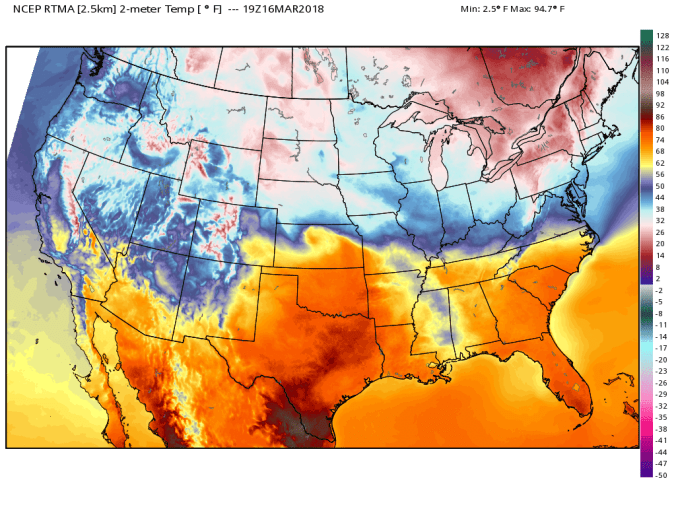
Radar today showing that early a.m burst in Garrett, north, but failed to pick it up across Tucker
Sun power of March, despite 20s, sun melted the back roads off except for drifting areas
Daily snippets..showing the a.m burst, if you sleep in, you would of missed it in parts of the area.


March to date on temps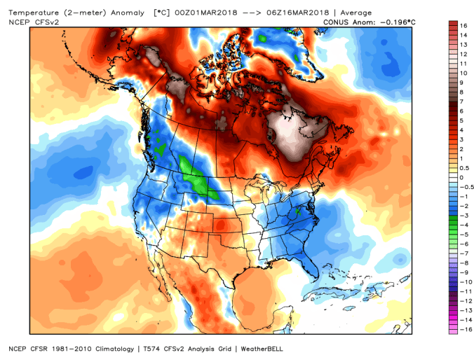
Saturday thoughts.
NWS has issued a advisory for portions of the area. Overall those look fine. If I were to add one thing, there is a window for a heavier batch of precip late morning, early afternoon somewhere from Somerset to Tucker, that should fall as snow and may put down some accumulation. It will need to fight marginal temps and occuring midday. Will update facebook tomorrow on how and if that materializes. So we start as a light mix (6-9am window) this blue zone may go to that period of snow midday.  Once precip backs off in the afternoon, light drizzle, freezing drizzle resumes, with some high ground fog. The southern high ground may mainly stay light liquid with this until late Saturday. Saturday night, precip exits, skies break north, dew points drop. Maybe some fog/rime across the northern mts early before the skies break, and high ground fog lingering across southern areas into the wee hours of Sunday. Northern areas that clear, much like last Sunday, temps drop off. Single digits in spots Sunday a.m in the colder valleys. Then we all rebound 38-45 Sunday. Very low dew points. Snow will melt in sunny areas, and basically stay status quo in shady area despite above freezing temps. North facing, wooded areas may even stay powder.
NWS outlook tomorrow..some of the sharp cutoffs are due to NWS WFO not seeing the same setup for their coverage zone.


We will have one more recovery day Monday, temps 39-46 with dry conditions before eyes go to the next event. Models are still waffling, north, south on track, and its really the model figuring out the placement, strength of multiple lows. Lots of potential with this event for areas that missed the big snows last week.
Next week off the 18z GFS ensembles
Gives a look at the variety of options on the model in terms of snow potential for next Tuesday-Thursday. With this being relatively far out, lots of tweeks to go. From a all snow event, rain to snow(leaning this way) to extended rain ending as snow. Potential exist for gefty hefty totals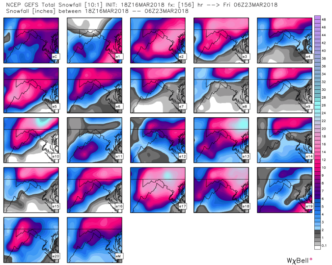
A lot of time, effort, and money is put into this site and facebook pages to keep updated on latest conditions. All a free service. If you enjoy the page, the site and would like to contribute and offset time, cost. Feel free to at secure paypal location.
