On at off snow at varying rates, few briefly heavy periods, times of light, moderate and times of nothing. The best snow remained north, east, and well south. Early morning burst covered main roads, but snow rates were not heavy enough to do that beyond early morning locally.
Snowfall Bittinger 2NW valley 1.6″ from 6pm last night through 9am. 1.4″ from 9a.m through 3pm, and .1 from 3pm through 6pm. 3.1″ total since last night at 6pm, and 10.7″ storm total with 8.8″ new depth with overall depths where old snow remained 12-15″. Season total 131.0″
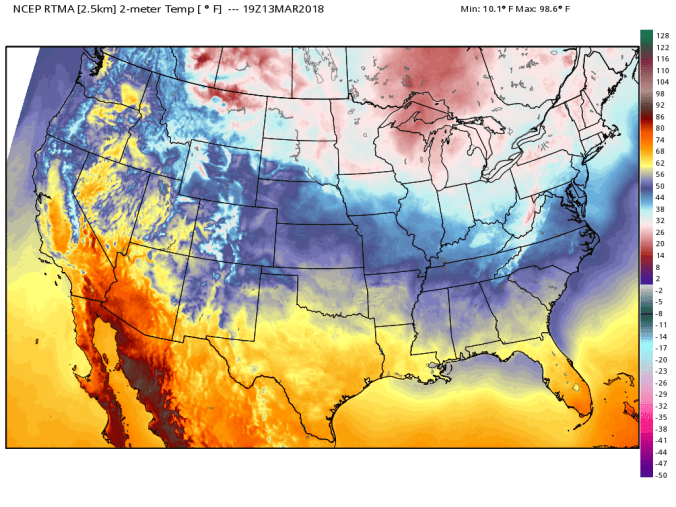
Temp profile today
Daily snippets
Radar from last night, showing heavier amounts south, and just north of the image range, heavier amounts in Pa…snow hole from part 2, southern half of Garrett, through Tucker, Preston
Snowfall amounts for 2 day totals. Area around Pitt will increase with updated map.
Northern Garrett Cam facing east, glazed over and then snowed over, not much to see on it today.
Canaan really missing out on the action today. Light glaze, little sleet
Frostburg State University in the heart of todays action
March 20. min. max. avg
Bitt 2NW valley 22.7 37.7 30.2
Garrett College 22.9 38.8 30.8
Can-Heights 21.6 37.5 29.5
CRN-Canaan 23.4 40.0 31.7
Cabin Mt 18.9 35.2 27.0
Cabin Mt north no data
Spruce Knob no data
Snowshoe/S.C 24.4 36.9 30.5
Can-Valley Floor 22.7 40.5 31.6
Cresaptown 30.8 45.3 38.0
Green Bank Obs 28.4 44.6 36.5
7Springs 24.5 37.5 31.0
A day where huge differences occured across some tight gradients. From heavy snow, to a light mix and mostly nothing. I began briefly with a light glaze, brief sleet to heavy periods of snow. From 8:30 to 10:30 over 4″ fell
Snowfall Bittinger 2NW valley 5.8 through 1pm, 1.8″ from 1pm through 6pm. Total 7.6″ today. 127.9″ on the season.
Video from near Bittinger this a.m
Daily snippets
Snow falling across western Md, Garrett through Washington County as well as that heavy band moving up into southern Pa. Further south, Allegheny front and east seeing much action than west of the front.
Radar today, snow avoiding some areas like the plague, while building elsewhere. Large differnce northern Garrett to southern Garrett
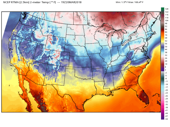
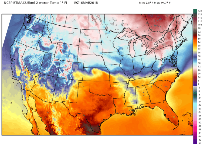
Temp profile this afternoon
ROUND 2 TONIGHT/TOMORROW
Overnight into tomorrow, round 2 develops. In general this looks like a widespread 4-8″ snowfall with areas that get into banding running 10-12″. Overnight, this area looks to be of high potential to see some of those heavy rates.
Tomorrow early morning to early afternoon that looks to trend north. This is still a bit questionable with some discrepancy in model output, but this area I think is the area to watch for some heavier rates. Always a tough call when the energy is transferred to the coast. The NW edge will loose oomph.
3km Nam run for tonight, tomorrow
Further ahead, models showing potential for a significant system the weekend affecting the southern Alleghenies. Until this current system clears, I don’t think the models will handle track of that real well. Will post on this more tomorrow.
As always, lots of time, and effort go into this page and the Facebook page with updates. A free service, but if you would like to contribute, feel free to at
Clear to start with some cloudiness later, more so south. Low dew points limited snow melt in north facing slopes, and shady areas.
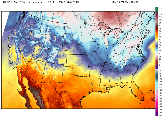
Temp profile this afternoon
Storm outlook Tuesday-Wednesday
First up, a look at today’s 12z ECMWF (AKA The Euro)
The model is in relative good agreement with its past runs and other modeling very similar. The GFS remains a bit of a outlier, but has came around.
Precip pushes in predawn tomorrow. Rain south, mix north and in this area
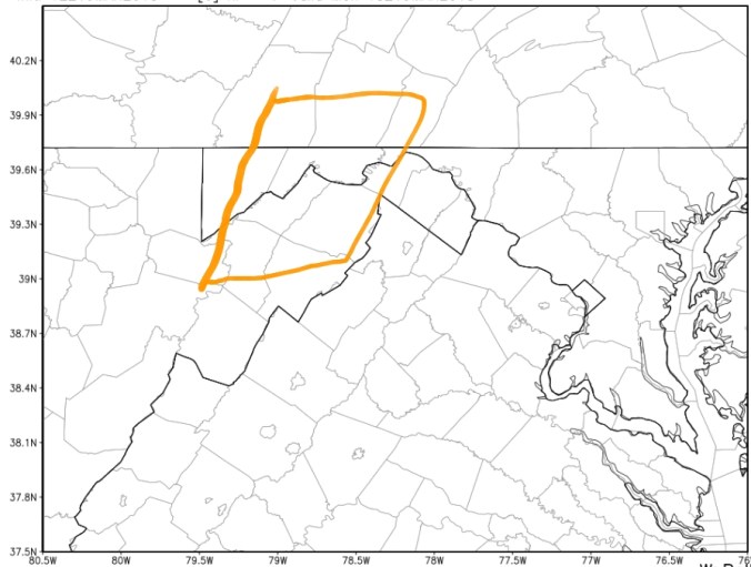
I think is the zone to watch for that brief mix to go to heavy snow early tomorrow. This is part 1. The current(posting this at 3:30pm) NWS outlook has the Winter Storm Warning beginning for later tomorrow and is not including this currently. This is an area to watch in my opinion for a quick changeover to snow and quick accumulation and poor driving early tomorrow. Likely a backoff period tomorrow then a return to accumulating snow. Timing is such the next round may come back during the night Tuesday and therefore could accumulate at better rates vs daytime snow. To note, lower elevations, and anywhere with lighter snows will struggle to accumlate during the day tomorrow and may compress what does fall. Snowfall totals likely will not be snowfall depths.
For some areas, this looks like it may be the biggest snowfall of the season. Refer to yesterdays post. Expanded the 6-12″ zone on latest guidance.
I always like to lean low to mid range of these numbers. Lower elevations in the zones, lean to the lower side, and figure in compression. On ground depths reduced to lower than actual snowfall amounts. High ground lean to the middle of the totals with potential to reach the top. Really like that Allegheny Front, Mt. Storm, Finzel area for this. Some areas will likely bust low, and or top the top end amount numbers. Its impossible to predict where heavier banding will setup, and where it will miss. Thats almost every storm. In general, these are my areas that look to be the hardest hit.
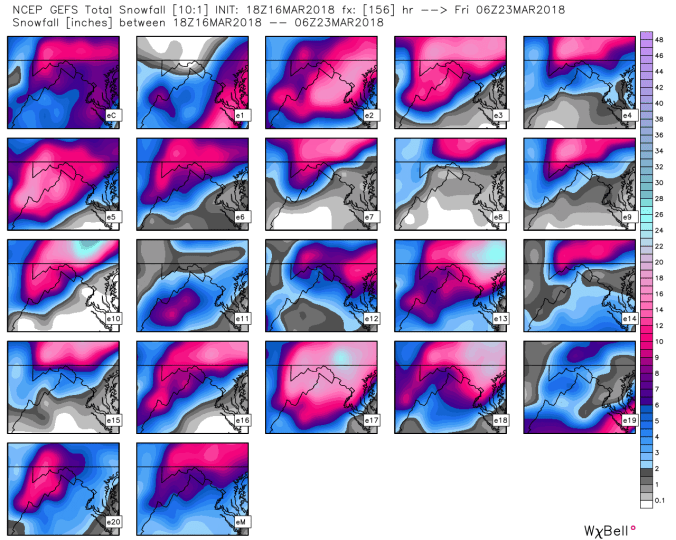
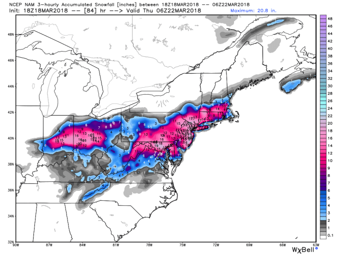
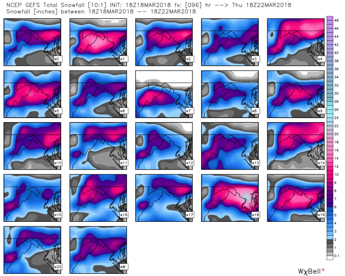
Lets look at some model totals. But first, bear in mind, models will not take into account, daytimes struggling to accumulate, and compression of snow. Ratios looking 8-12 to 1 with this.
Here are the models… A tool to gives a idea where the heavier amounts will fall. Not the gospel of what will exactly fall. Models still at a bit of odds on the second piece tomorrow night. Parts of Wv that were hit last week, may sneak in a better snow period than forecast. I think Pocahontas County, 50-70 miles west need watched for that. Complex setup, tweaks, adjustments will need made and in the end, even those will ne off with areas that did better or worse.
Once this clears, we turn eyes to the weekend system. Gfs suppresses the storm south. Rising NAO, correction is likely north, 12z ECMWF is a hit on the region. Canadian is north and would equal a mix, sleet, snow, rain. So that needs watched. Could be a active weekend unless the GFS wins the day. Long range continues the big highs north with systems cutting underneath. May be talking snow potential into the first week of April. With milder interludes in between.
As always, lots of time, effort go into this free service, if you would like to contribute, feel free, if not, enjoy, cause I’ll do it anyway. You can at-
Wall to wall sun. Cold start, milder day vs the previous week. Low dew points, the dry air doesn’t allow for much snow melt on the north facing slopes and shaded areas, while the March sun does its work elsewhere.
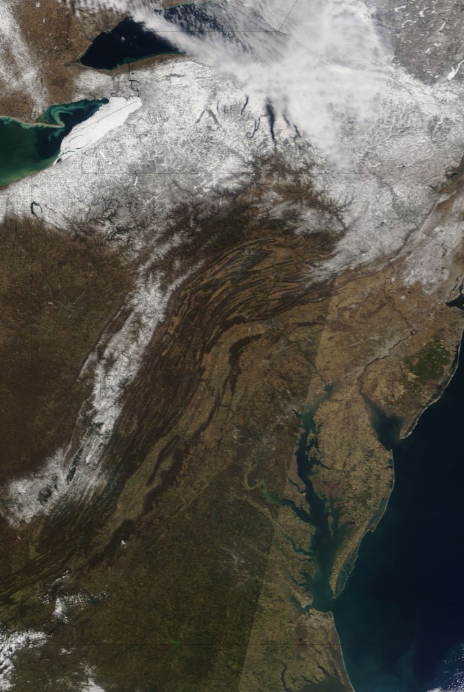
Modis satellite image today showing the snowcover through the Alleghenies.
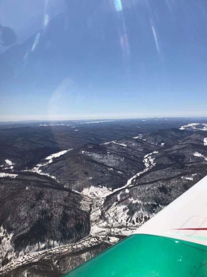
Pic below by Peggy Thorne Church flying over Harman today
Tuesday-Thursday Snow Event
Caution- Models are trying to piece together how this system will play out. With so many players on the field, the models have struggled to figure out which piece is strongest, if it will have room to trend north, and therefore track, timing has been back and forth on the models. Today, some converging has occured. Is it final? No. That said, this system does have the potential to be the biggest snow of the season for parts of the area.
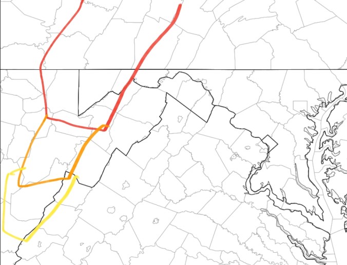
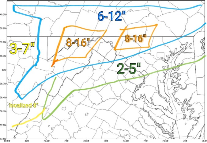
As of this evening, this is the area that looks like the heaviest axis may occur, and that window will tighten as we get closer and a trend north or south may still occur. If anything, I’d lean north if it does trend. Its one of those systems I like for the Allegheny Front, Mt. Storm, Savage Mt best. That area, and then on east. If this materializes, as it looks like it could, the heaviest zone could be in the 8-16″ window. (orange zone)With higher pops east. Outside of that, in that blue zone 6-12″. Elsewhere common amounts of 3-6″.
Things to consider- Timing. How much falls during daylight hours. It looks to come in predawn Tuesday. Snow during Tuesday. Anytime snow rates go lighter, it will be harder to accumulate during the day and on the ground amounts may compress. (Especially lower elevations, 6″ -8″may never be more than 2 to 4″ on the ground. Timing and rates important)Actual fallen amounts may not equal actual snowfall depth. I don’t see this being high ratios. 8-12 to 1 range. Marginal temps, but cold enough to support snow. Onset could very briefly begin as a mix. Snow continues Tuesday night, Wednesday at varying rates and lingers possibly into Thursday a.m in the Alleghenies.
We still have a ways to go, this can still trend north, south, lighter, heavier. .
On the models. Here is the 12z ECMWF
Snowfall off the model
18z Nam outlook
Snowfall off the model
Good combo to begin seeing if the Nam and ECMWF line up. The 12z ECMWF also has lots of agreement in its ensembles.
18z GFS ensembles
Watching next weekend with another system coming across. That potentially could set up a wintry period for the snowmobile races at Timberline resort.
As always, lots of time, effort, and cost go in to provide this free service. If you would like to contribute, you can at
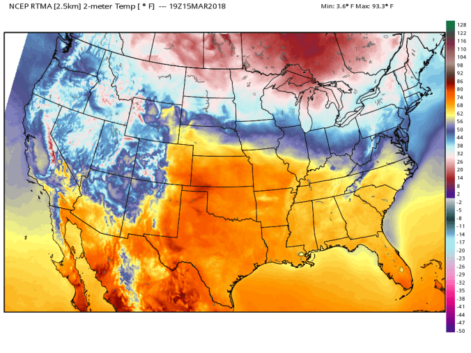
Clouding up early morning. Much colder northern Alleghenies vs Southern Alleghenies at the high ground. Cold valleys remained in the southern Alleghenies through the morning hours. Some freezing rain in those areas, some light rain at the high ground. Further north some light snow and a swath of moderate snow near mason dixon line early to mid afternoon. Marginal temps limited accumulation
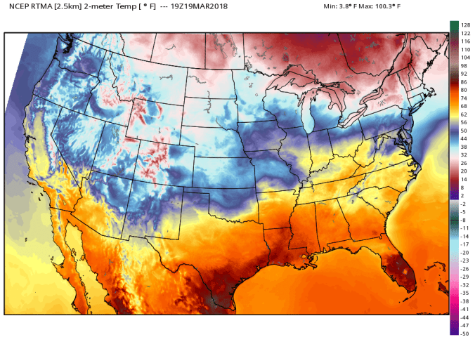
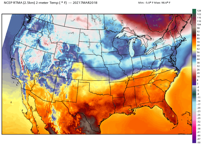
Afternoon temp profile of the nation
Snowfall Bittinger 2NW valley – .8″ 120.3″ on the season.
Report by Dave Lesher at Canaan Heights today “Becoming cloudy overnight with temperatures rising from the teens to the high 20s at daybreak. Light snow commenced at mid day and quickly turned into a short period of heavy goosedown flakes then quickly ended with a little sleet later in the afternoon. Daytime high 39F, dropping to the low 30s by evening.”
Report from David Podlesnik in Springs Pa “All heavy snow today .40 in Springs 33°f and 1.10 on Mt. Davis 30°f after the sun was out for about an hour.”
Snow period early afternoon
Afternoon snow across Garrett-
Pics below by Jeremy Cutlip in Mountain Grove Va this morning
Heavy burst of snow predawn, to dawn across northern Alleghenies and lingering early daylight hours central Alleghenies. Skies then breaking with plenty O sun.
Snowfall- Bittinger 2nw Valley .9″ 119.5″ on the season.
Afternoon national temp profile
Radar today showing that early a.m burst in Garrett, north, but failed to pick it up across Tucker
Sun power of March, despite 20s, sun melted the back roads off except for drifting areas
Daily snippets..showing the a.m burst, if you sleep in, you would of missed it in parts of the area.
March to date on temps
Saturday thoughts.
NWS has issued a advisory for portions of the area. Overall those look fine. If I were to add one thing, there is a window for a heavier batch of precip late morning, early afternoon somewhere from Somerset to Tucker, that should fall as snow and may put down some accumulation. It will need to fight marginal temps and occuring midday. Will update facebook tomorrow on how and if that materializes. So we start as a light mix (6-9am window) this blue zone may go to that period of snow midday. Once precip backs off in the afternoon, light drizzle, freezing drizzle resumes, with some high ground fog. The southern high ground may mainly stay light liquid with this until late Saturday. Saturday night, precip exits, skies break north, dew points drop. Maybe some fog/rime across the northern mts early before the skies break, and high ground fog lingering across southern areas into the wee hours of Sunday. Northern areas that clear, much like last Sunday, temps drop off. Single digits in spots Sunday a.m in the colder valleys. Then we all rebound 38-45 Sunday. Very low dew points. Snow will melt in sunny areas, and basically stay status quo in shady area despite above freezing temps. North facing, wooded areas may even stay powder.
NWS outlook tomorrow..some of the sharp cutoffs are due to NWS WFO not seeing the same setup for their coverage zone.
We will have one more recovery day Monday, temps 39-46 with dry conditions before eyes go to the next event. Models are still waffling, north, south on track, and its really the model figuring out the placement, strength of multiple lows. Lots of potential with this event for areas that missed the big snows last week.
Next week off the 18z GFS ensembles
Gives a look at the variety of options on the model in terms of snow potential for next Tuesday-Thursday. With this being relatively far out, lots of tweeks to go. From a all snow event, rain to snow(leaning this way) to extended rain ending as snow. Potential exist for gefty hefty totals
A lot of time, effort, and money is put into this site and facebook pages to keep updated on latest conditions. All a free service. If you enjoy the page, the site and would like to contribute and offset time, cost. Feel free to at secure paypal location.
Snow showers, flurries, at varying rates scattered about today intetmixed with some sun. Breezy.
Snowfall- Bittinger 2nw Valley .2″ fluff overnight from 6pm till 7am. Snow ended near midnight. Snow began again this a.m and briefly moderate and flurries lingered through midday. .2″ with this event for new total of .4″. Season to date total 118.6″
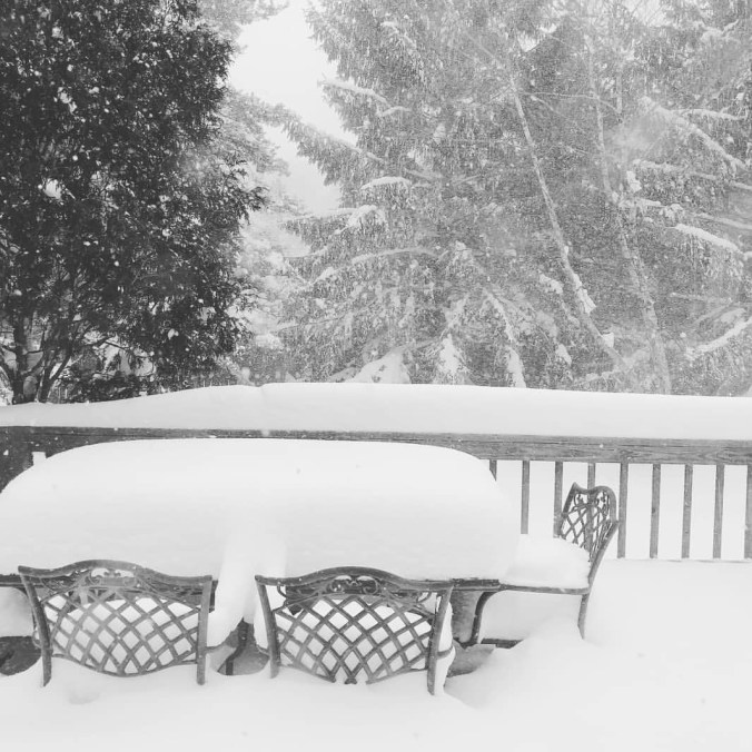
Snow at Bittinger 2nw Valley this a.m. Intensity was briefly heavier than this a few times.
Temp profile this afternoon
Pic below by Golden Anchor Cabins at Canaan. Beautiful views at the cabins looking towards the snow covered Mt. Porte Crayon
Daily snippets
Saturday’s thoughts and the potential storm next week:
Overnight Friday, Saturday a.m, temps will be on the rise. The most noticeable rise will occur across the high ground of the southern Alleghenies.
Breakdown: The yellow zone, especially the high ground will see a temp rise overnight Friday into Saturday a.m, to 33-38° and should equate to any precip being in liquid form. Air aloft here is not conducive for snow. If any freezing were to occur, low lying valleys with the snowpack would be a hold out for that. Even that looks slim.
Orange zone- precip timing will be key. The earlier it arrives, the more likelihood of seeing some freezing rain, especially in the valleys. All areas should come up above freezing by mid morning to midday.
Red zone- Again, precip timing is key. If it arrives fast enough, it will begin as snow/rain mix. Air aloft is borderline cold enough. Any early mixing with temps near 30-33 should briefly transition to a rain, snow and later on primarily snow as cold air aloft bleeds back in. While the air aloft is turning colder, surface temps may rise 33-36 during the main precip. Therefore, I dont see much accumulation of snow. Except if we see some heavier precip rates and the high ground could pick up a inch of wet snow.
After the main precip pulls away, the high ground is left with some fine light snow, freezing drizzle with little to no accumulation of snow. Some brief riming is possible above 2800′ , above 3500 across Wv as colder air filters backk in. Skies should break overnight.
Next Week
Right now, models have trended into a favorable position for a good size snow event for portions of the area. Being 5 days out, this will adjust day by day. A complicated setup once more.
Without going into the teeny tiny details, there is plenty that can change, but this has the looks of a late season special for the Allegheny Front, Mt. Storm, Savage Mt. Some areas that missed out on this past weeks storm, could potentially see their best snow of the season if the modeled track remains similiar to how its presently modeled.
Some model output off the runs today. Modeled 12Z ECMWF for the system at the surface. Pic 1 and 2, and 12Z GFS at the surface in pic 3 and 4. Then the ensemble members for snow amounts off the 12z ECMWF and the Operation run off the model. Lots of support for the storm, track will need honed in as we get closer, to determine how this may play out.
If you have enjoyed the weather updates on facebook, or here on this site, and they have been of benefit to you, feel free to contribute to help offset the cost of my model access and time and effort put into this at
A squally day. Periods of heavy snow. Breaks with some sun. Repeat. Some areas saw more snow than breaks and vice versa elsewhere. Mchenry area was under the gun more so than Bittinger to Grantsville.
Snowfall at Bittinger 2nw Valley. 2″ from 6pm through 7am. 1.7″ from 7am through 1pm. 1.4″ from 1pm through 6pm. 1.1″ fell in 20 minutes with a heavy squall around 5pm. Overall 5.1″ through 6pm. Season total to 114.8. Heavy squalls occured after 6pm that will be tallied at 7am.
Canaan Heights- 6″ overnight, 3.6″ today season total 132.5
Snow this morning. Period of moderate snow north while heavy snow southern Alleghenies, and west towards Summersville, Craigsville, Calvin… 10-18″ in that vicinity.
Snowfall- Bittinger 2nw Valley 1.4″ today, with 1.3 of that in the morning hours of 7-9am. 109.7 on the season.
Canaan Heights .8″ today, 122.9 on the season.
Temps today at Bittinger 2nw Valley, Cabin Mt and national profile this afternoon
Daily snippets 3rd pic Snowfall measurement by Rosanna Springston at Calvin, Wv, 4th pic this morning by Anne Johnson in Summersville. Snippets from various webcams and social media.. Snowshoe making snow late day on top the falling snow, looks like they’re going for Easter.
Todays radar…circled is the area that was hardest hit with some very heavy snowfall rates. 2-4″ per hour at times.
Models tried to pick up on the snowfall rates. The 3km nam did pic out 2-3″ hour rates this morning at 10 to 1 ratio. I don’t have the SWE yet, but at that time of day in which it fell, the temps, wind, snowflake structure. I’d guess 12-15 to 1, so the model in reality did well.
Pics by Rosanna Springston, pic from Calvin and Craigsville
Pics by Jeremy Cutlip around Mountain Grove, Va. Coming in near 8″
Snowshoe 10pm
On the models
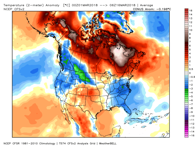
The below normal temp theme continues for March. Upslope snows through Thursday and may linger into Friday. More details on Facebook. Weekend looks to moderate. One must be careful forecasting warmth with big highs north. Mentioned this past several days on facebook. This “can” thwart off medium range warm looks on models. Not saying it will, but an option for sure.
Ensembles look cold day 8+, the just in Euro Weeklies hold a below normal theme the next month.
25th Anniversary Of The Blizzard Of 93′
As hard as it is to believe, a quarter century has passed by since the great Blizzard of 93′. A storm that from a week away computer models were showing and showing such a strong storm, it wasnt know if it was a chance it was real. I remember WJACTV weatherman Steve Richards from a week out talking about the incoming storm. It lived up to the hype and then some. Closing roads and schools across the entire region for over a week in places.


 Once precip backs off in the afternoon, light drizzle, freezing drizzle resumes, with some high ground fog. The southern high ground may mainly stay light liquid with this until late Saturday. Saturday night, precip exits, skies break north, dew points drop. Maybe some fog/rime across the northern mts early before the skies break, and high ground fog lingering across southern areas into the wee hours of Sunday. Northern areas that clear, much like last Sunday, temps drop off. Single digits in spots Sunday a.m in the colder valleys. Then we all rebound 38-45 Sunday. Very low dew points. Snow will melt in sunny areas, and basically stay status quo in shady area despite above freezing temps. North facing, wooded areas may even stay powder.