April 10.                min.         max.       avg

Bitt 2nw valley      24.5       41.5       33.0

Garrett College     26.5        40.0       33.2

Can-Heights           23.1        38.2       30.7

CRN-Canaan          24.6       39.5        32.1

Cabin Mt              20.3        36.9        28.6

Cabin Mt north no data

Spruce Knob no data

Snowshoe/S.C     20.5        30.6       25.5

Can-Valley Floor

Cresaptown           31.3       55.4     43.3

Green Bank Obs    26.7      43.0     34.8

7Springs                  25.0      38.3     31.6

Few clouds to start to sunshine. Clouds rebuilding afternoon. Early morning glaze on cams from freezing drizzle last night…

Temp profile this afternoonrtma_t2m_conus2

Only a trace of snow overnight at Bittinger 2nw Valley received_1898113076867511

more pics on the day


April 9                 min.          max.       avg

Bitt 2nw valley    23.4          29.9      26.6

Garrett College    24.2         30.3      27.2

Can-Heights          23.2        30.6      26.9

CRN-Canaan         23.6       30.2      26.9

Cabin Mt               18.3       27.5      22.9

Cabin Mt north no data

Spruce Knob no data

Snowshoe/S.C    21.0         28.0       24.5

Can-Valley Floor

Cresaptown         33.5          37.6     35.5

Green Bank Obs   26.9        32.4     29.7

7Springs               24.5         30.4     27.5

Period of moderate snow early, then lighter, but mainly on most of the day. Late afternoon it mixed with freezing drizzle at times. Despite low precip rates, snow accumulated .4″ today. Heavy cloud cover limiting solar radiation and from 10am on temps holding 20s allowed for that. Further south in Canaan, snow appeared lighter. Further south, Snowshoe and through Pocahontas, Greenbrier it ramped up much higher.

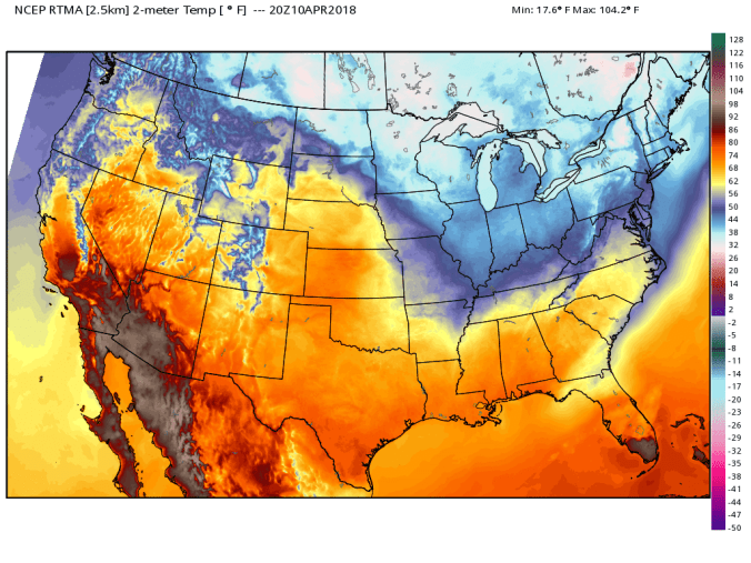
Temps at Bittinger 2nw Valley today and national profile this afternoon


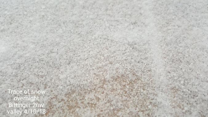
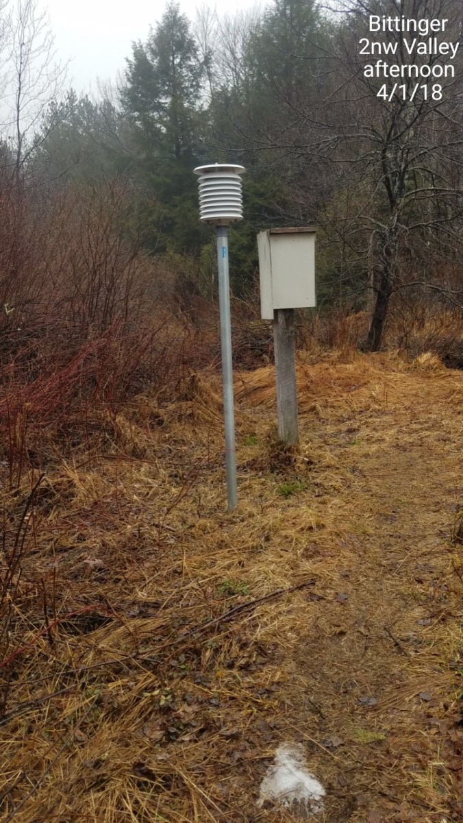
Snowfall at Bittinger 2nw Valley 1.3″ total today.   .9″ by 8am(no boardsweep) and added .4″ by 3pm with a depth of 1.3″. On top of that some light freezing drizzle, fine snow pellets. This continued to nightall with no additional accumulation at that time. 140.0″ on the season.


Canaan Heights in at .9″ total, with 149.1 on the season

http://data.canaanmtnsnow.com

Rosanna Springston reported 5.5″ at 11am at the Cranberry Nature Center, with snow continuing through the afternoon but snow depth compressing to 5″,  and Jeremy Cutlip had 3″ at Mt. Grove Va. Below in vid is pics by them as well as area webcams

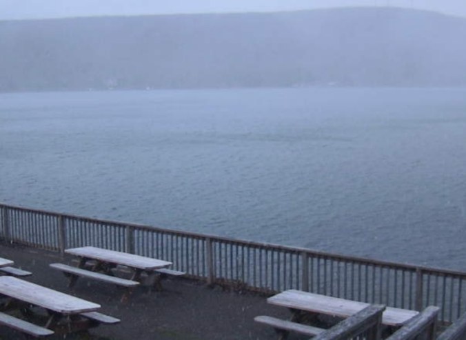
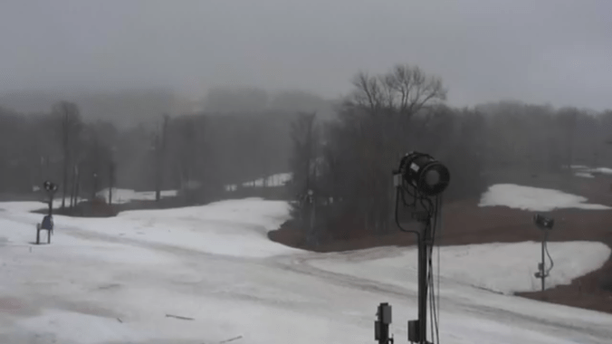
Area views on the day

2 years to date since the very impressive upslope event in the Alleghenies with Canaan leading the way with over a foot and a half of snow. I would estimate 20+” above 4000″.

http://epod.usra.edu/blog/2016/04/april-blizzard-in-cannan-valley-west-virginia.html


April 8                  min.         max.       avg

Bitt 2nw valley   14.7         38.1        26.4

Garrett College    20.5        36.0        28.2

Can-Heights         15.9        34.9       25.4

CRN-Canaan        18.7        34.8        26.8

Cabin Mt               14.4        33.8       24.1

Cabin Mt north no data

Spruce Knob no data

Snowshoe/S.C       14.7        29.7      22.2

Can-Valley Floor

Cresaptown           20.3        52.5      36.0

Green Bank Obs   17.5        41.1       29.3

7Springs               23.1          34.0      28.5

Partly cloudy skies, brief period of passing light snow showers this a.m. Overall a partly cloudy day with plenty o sun.

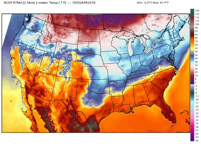
Temps well into the teebs this a.m under clear skies. A very light breeze held up just enough to prevent a further temp drop. Temps at Bittinger 2nw valley, The Glades, and national profile this afternoon.


Views on the day


April 7                    min.         max.        avg

Bitt 2nw valley      19.2         34.4        26.8

Garrett College      21.6         34.4        28.0

Can-Heights           16.9          38.5       27.7

CRN-Canaan           20.3          36.5      28.4

Cabin Mt                 15.8          36.5      26.1

Cabin Mt north no data

Spruce Knob  no data

Snowshoe/S.C.     17.8        44.1       30.9

Can-Valley Floor

Cresaptown          26.1       49.1       37.6

Green Bank Obs. 22.6      53.6       38.1

7Springs                 22.1     32.5       27.3

Light snow early to cloudy skies, north winds. Skies cleared late north, light snow cover remained through the day in many areas except direct sunny areas that were hit late.. snow showers hung into afternoon in Wv


Snowfall at Bittinger 2nw Valley at 7am 1.1″ with no additional accumulation. 138.7 on the season.

7Springs reporting 2″ and still open this weekend for skiing

Views on the day


April 6.                min.         max.        avg

Bitt 2nw valley   29.6          55.8       42.7

Garrett College     32.2         54.1      43.2

Can-Heights          31.3         55.4      43.3

CRN-Canaan          32.8         56.1      44.4

Cabin Mt                 29.5        52.0       40.8

Cabin Mt north no data

Spruce Knob no data

Snowshoe/S.C         32.7          52.2      42.5

Can-Valley Floor

Cresaptown             34.0          69.6     51.5

Green Bank Obs      28.0         63.5     45.8

7Springs                   32.5          53.9     43.1

Cloudy, cold start, to breaking skies afternoon with persistent winds. Temps milded up afternoon.

Temps at Bittinger 2nw Valley and afternoon profile nationally


2018-04-05-18-05-52

April 5             min.         max.        avg

Bitt 2nw valley  22.1          39.7       30.9

Garrett College 22.9           39.2       31.0

Can-Heights       18.5           37.1      27.8

CRN-Canaan      19.6           36.6      28.1

Cabin Mt             14.7          33.8       24.2

Cabin Mt north no data

Spruce Knob no data

Snowshoe/S.C       14.7         34.3      24.5

Can-Valley Floor

Cresaptown         31.8           53.3     42.4

Green Bank Obs  23.5          45.5      34.5

7Springs                23.4         40.1       31.7

Day began with light snow showers that turned to moderate snowshowers in spots from 8-10am, then broke by 11 am, and sun came out and melted all the snow rapidly except shady areas.


Snowfall at Bittinger 2nw Valley. At 7am .2″ of snow fell overnight. The moderate snow from 8am to 10am put down an additional .4″ for a .6″ total on the event. Season total at 137.6″

More pics here


April 4.               min.         max.          avg

Bitt 2NW valley   25.1       53.3        39.2

Garrett College     24.6      57.6         41.1

Can-Heights          21.2       56.4        38.8

CRN-Canaan          22.4       58.3       40.3

Cabin Mt                18.0       54.9        36.5

Cabin Mt north no data

Spruce Knob no data

Snowshoe/S.C       19.4          53.2       36.3

Can-Valley Floor

Cresaptown           36.0         57.4       46.6

Green Bank Obs    28.5        56.4        42.5

7Springs                  26.0        57.5       41.8

rain early, very windy, falling temps. Scattered light snow showers late morning, afternoon, with some moderate snowshowers at nightfall coating things white.

Daily views

Deep Creek Lake 8pmScreenshot_20180404-194145.jpg

Timberline this afternoonScreenshot_20180404-111648

https://www.facebook.com/groups/368828993225128/permalink/1614606601980688/ Video by Vernon Patterson at Blackwater Falls today


April 3.                 min.          max.       avg

Bitt 2NW valley   34.3          51.9       43.1

Garrett College    31.5          56.2       43.8

Can-Heights         39.5          58.0       48.8

CRN-Canaan        39.2          59.4       49.3

Cabin Mt               40.1         57.2       48.7

Cabin Mt north no data no

Spruce Knob no data

Snowshoe/S.C.       40.8        54.1       47.4

Can-Valley Floor

Cresaptown           41.4        53.4       47.4

Green Bank Obs   43.6        57.9       50.8

7Springs                 35.6       53.6        44.6

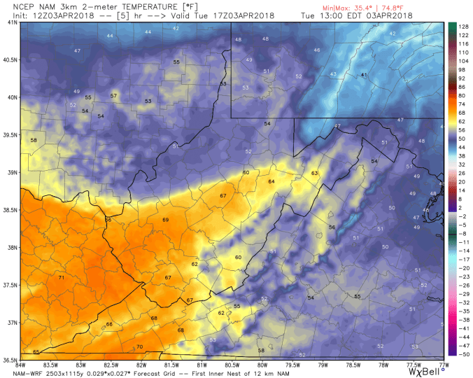
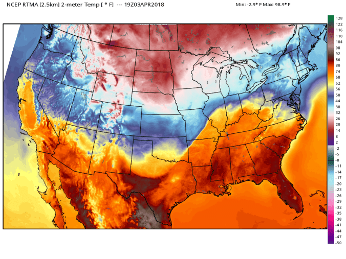
Cloudy, rainy, dreary day. Cool air hung tough. Late day skies broke and warm punch progressed. 3km nam did excellent again on temp setup.

With the 3km nam doing so well on temp setup, it actually resembled setup more accurately than the rtma analysis, so here is a snippet from 3km nam todayhires_t2m_wv_6.png

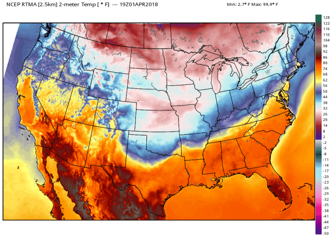
Temp profile nationally this afternoonrtma_t2m_conus2

Rainfall today across northern Garrett ranged in the .75 to 1 range. That along with a high water content snow melt, was enough to send small creeks out of their banks.


Radar

Daily views


2018-04-02-09-56-57.jpg

April 2                 min.       max.         avg

Bitt 2NW valley  30.9       38.7       34.8

Garrett College   30.8       41.1        35.9

Can-Heights        31.1       43.0        37.0

CRN-Canaan       32.2       46.8        39.5

Cabin Mt             30.6        43.9       37.2

Cabin Mt north no data

Spruce Knob no data

Snowshoe/S.C       32.4        48.2      40.3

Can-Valley Floor

Cresaptown          34.2       47.0       40.6

Green Bank Obs  41.0       57.8        49.4

7Springs                30.9       38.5        34.7

A very sharp contrast overnight from northern Tucker north vs south. Mainly rain for most of Tucker south, with snow north and quick heavy accumulations in a brief several hour window. Cloudy, fog this morning to mainly cloudy with breaks of sun south of Garrett this afternoon.


Bittinger 2nw Valley snowfall. Right on the button at 6.0″, with 137.0 on the season to date.

Radar today…above the yellow, primarily snow overnight, the pink rain to snow

Temp profile todayrtma_t2m_conus2

more pics today

Rt. 40 elementry school in Garrett

Frostburg State University…. shows the brief heavy snow period

Videos across Garrett County

2018-04-01-20-07-04

April 1.               min.          max.       avg

Bitt 2NW valley  29.6       45.2       37.4

Garrett College   33.4       46.0       39.7

Can-Heights        35.0       43.5       39.2

CRN-Canaan       35.9       44.7       40.3

Cabin Mt              33.6       41.5      37.5

Cabin Mt north no data

Spruce Knob no data

Snowshoe/S.C      36.7        42.3       39.5

Can-Valley Floor

Cresaptown         39.0       57.8        48.4

Green Bank Obs    30.4     51.8       41.1

7Springs               31.1        46.7       38.9

Cloudy, foggy, drizzly…temps dipped near freezing late morning Garrett in spots. Skies broke early afternoon north, and went to blue skies in Pa. partly cloudy late day northern Garrett, clouds, fog hung on in Wv.

Temp profile this afternoonrtma_t2m_conus2

Daily snippets