May 21.                min.         max.        avg

Bitt 2nw valley   50.2         74.9        62.5

Garrett College.  52.7         77.5        65.1

Can-Heights        55.9         75.6       65.8

CRN-Canaan        53.4         77.5       65.4

Cabin Mt               56.8        72.5       64.7

Cabin Mt north no data

Spruce Knob        56.3        67.5       61.9

Snowshoe/S.C      56.5         72.9      64.7

Can-Valley Floor

Green Bank Obs  55.4         80.1      67.8

7Springs                56.1         81.1     68.6

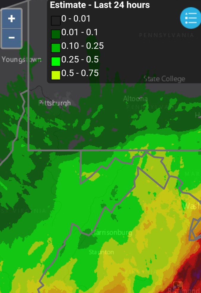
Some early fog, low clouds, sprinkles to partly sunny…semi muggy feel. Late day/early nightfall storms.
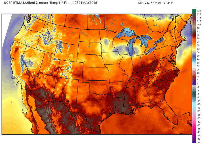
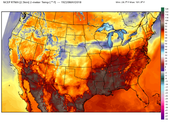
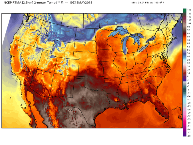
Temp profilertma_t2m_conus2


May 20.               min.         max.         avg

Bitt 2nw valley  58.7        74.4        66.5

Garrett College  59.3        74.1       66.7

Can-Heights        57.6        70.8       64.2

CRN-Canaan        58.3       71.5       64.9

Cabin Mt              56.7        70.3       63.5

Cabin Mt north no data no

Spruce Knob       55.6        69.4       62.5

Snowshoe/S.C    56.7         67.8       62.2

Can-Valley Floor

Green Bank Obs  57.0        80.1       68.6

7Springs                 61.0       73.3      67.1

Dreary start, fog, to sunny breaks afternoon. Some Wv mt showers in the afternoon.

Temp profilertma_t2m_conus2

May 19.                min.           max.       avg

Bitt 2nw valley   48.4            63.3       55.8

Garrett College    48.5          70.8       59.7

Can-Heights         50.7          71.8       61.2

CRN-Canaan        52.6           72.4      62.5

Cabin Mt               48.0          67.5      57.8

Cabin Mt north no data no

Spruce Knob      48.4          66.2       57.3

Snowshoe/S.C     53.1         62.4      57.8

Can-Valley Floor

Green Bank Obs  57.5        72.3     64.9

7Springs               50.5          74.6    62.5

A setup today that gave a variation across Garrett…At Bittinger 2nw Valley, the day began foggy and stayed dreary through midday with showers before brightening…brightened earlier west. and sun broke out through Garrett except eastern part near Savage Mt and points east. That had a affect on temps. Showers again late in the day, with pockets of downpours and some lightning,thunder.

Afternoon temp setup..using the 3km nam as it looked more in line with reality vs rtma.

hires_t2m_wv_7

Satellite

Savage Mt while most of county had sun

Wind flow 5/19/18

Late day showers, storms

Month to date precip


May 18.               min.          max.        avg

Bitt 2nw valley   53.4        62.4        57.9

Garrett College   53.8         61.4       57.6

Can-Heights        52.2         58.7       55.5

CRN-Canaan       53.2         61.8        57.5

Cabin Mt              49.6        56.8        53.2

Cabin Mt north no data no

Spruce Knob       50.4          55.9      53.2

Snowshoe/S.C      54.3         57.6      55.9

Can-Valley Floor

Green Bank Obs  59.4          67.3      63.4

7Springs               55.1          64.8      60.0

Cloudy, drizzle, east wind….a very brief dry period this a.m in some northwestern parts of Alleghenies…very brief. Drizzle, light rain picked up late day. Temps slowly fell late day

Temp profilertma_t2m_conus2

Radar

Screenshot_20180518-210154

Satellite

Wind direction today


May 17.                   min.           max.      avg

Bitt 2nw valley       58.8         63.3       61.0

Garrett College       59.8         64.5       62.2

Can-Heights            56.9         59.5       58.2

CRN-Canaan           57.8          60.5      59.1

Cabin Mt                 54.3         56.7      55.5

Cabin Mt north no data no

Spruce Knob          53.8         56.8      55.3

Snowshoe/S.C        55.0         58.6      56.8

Can-Valley Floor

Green Bank Obs  59.8         65.0        62.4

7Springs                60.6         70.0       65.3

Rainy, cloudy, some fog..near steady temps

Temp profile


Radar

Precip totals today range from .5 north to nearly 2″ in some Wv locations.

May 16.                min.          max.      avg

Bitt 2nw valley   58.1          69.0      63.5

Garrett College   59.7          70.7     65.2

Can-Heights       56.3           69.7    63.0

CRN-Canaan      56.2           69.3     62.8

Cabin Mt             54.3          66.4      60.3

Cabin Mt north no data no

Spruce Knob        54.3          63.1    58.7

Snowshoe/S.C.     55.2         64.2     59.7

Can-Valley Floor

Green Bank Obs  57.5         69.6      63.5

7Springs                 61.3        74.2      67.7

Cloudy, intervals of rain, some periods of dryness, rain increasing later afternoon..

Temp profile


Radar today

May 15.                  min.        max.        avg

Bitt 2nw valley     51.6        82.3        66.9

Garrett College     57.7       80.8        69.2

Can-Heights          59.3        78.3        68.8

CRN-Canaan         59.1         77.9       68.5

Cabin Mt               57.2         75.9       66.6

Cabin Mt north no data no

Spruce Knob       56.3        76.5        66.4

Can-Valley Floor

Snowshoe/S.C       58.3       74.7       66.4

Green Bank Obs  51.7        87.0      69.3

7Springs               60.1        81.8       70.9

Partly cloudy, warm, some rain after dark…earlier south

Temp profile this afternoonrtma_t2m_conus2.png

estimated rain totals today…bad flooding in Frederick areaScreenshot_20180515-224742

2 years ago today, Wv high ground had about 1 inch of snow. It remained above about 4200 until the daytime hours on the 16th


May 14.                  min.        max.         avg

Bitt 2nw valley    53.8         80.9        67.3

Garrett College   57.8         80.4       69.1

Can-Heights        57.5          78.3       67.9

CRN-Canaan       57.8           77.4      67.6

Cabin Mt              55.0          77.0      66.0

Cabin Mt north no data

Spruce Knob        52.5         75.2     63.8

Snowshoe/S.C       56.1        75.6     65.8

Can-Valley Floor

Green Bank Obs 55.3        85.1      70.2

7Springs              61.5        77.4      69.4

Storms to start, then partly cloudy, then strong storms pushing through.

Temp profile before and after storms

Past 24 hour rainfall estimationScreenshot_20180514-195202

Satellite view, storm tops blowing up

lightning on cam

storm coming across North Fork Mt

Late edition, spectacular sunset off webcams. Even Northern Garrett Accident, looking east, and the western sky ablaze from Rt. 40 elementary…also pic by Todd Romero at Canaan

Snowshoe with patches of snow leftScreenshot_20180514-203959


May 13.              min.           max.       avg

Bitt 2nw valley  56.7          76.4       66.5

Garrett College 58.4           76.0       67.2

Can-Heights       57.5          74.3        65.9

CRN-Canaan       57.6          74.8       66.2

Cabin Mt             55.6           74.3      64.9

Cabin Mt north no data

Spruce Knob      55.6            74.3      64.9

Snowshoe/S.C     59.7           73.9      66.8

Can-Valley Floor

Green Bank Obs 55.1         84.3      69.7

7Springs              58.5         77.5      67.9

Some fog, rain to start, then breaks of sun to showers, storms late. Tornado warned storm im Bedford County.

Temp profile this afternoonrtma_t2m_conus2

Rainfall through morningScreenshot_20180513-074955


Radar today

Satellite this afternoon

May 12.                 min.          max.       avg

Bitt 2nw valley  48.3        81.0         64.6

Garrett College   56.6        78.5          67.6

Can-Heights         57.5        77.7        67.6

CRN-Canaan        60.9        77.2        69.0

Cabin Mt              60.4        76.5        68.4

Cabin Mt north  no data

Spruce Knob        58.5        75.6       67.1

Snowshoe/S.C        61.2       73.8       67.5

Can-Valley Floor

Cresaptown**       52.4      96.5**   74.2**

Green Bank Obs  50.1       84.5       67.3

7Springs               57.6       81.1       69.3

** Cresaptown will be discontinued for obvious poor station siting or some error**

Partly sunny, breezy to storms northern Alleghenies(Garrett-north) late day.

Temp profilertma_t2m_conus2