Clear, valley fog to start, subshine with a few pop up clouds during the afternoon and evening.
Temp profile this afternoon
Satellite this afternoon
Flow
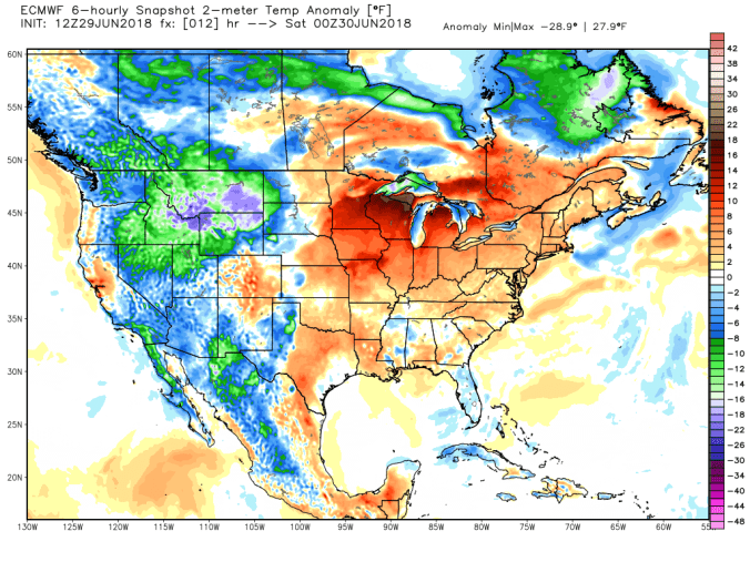
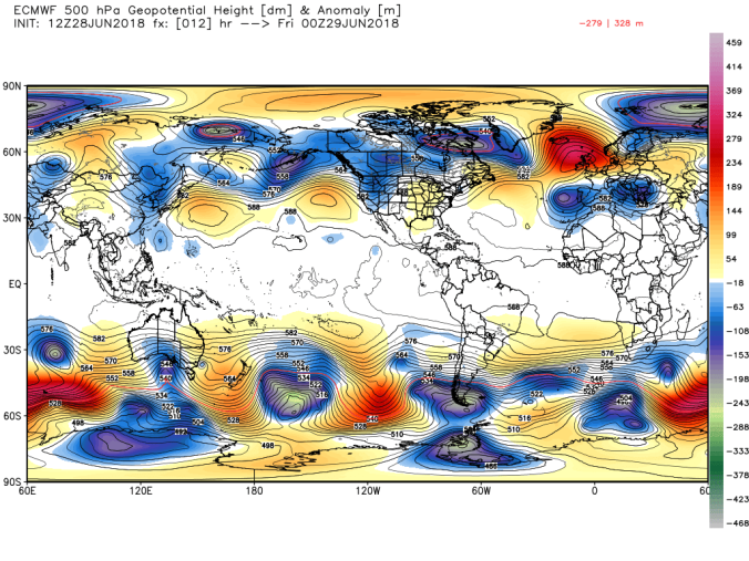
500mb anomaly today
Resulting temp anomaly
With building heights, high pressure, it should still allow for nighttime lows to drop into the comfortable range in the valleys. Warmest nights typically come at the end of the warm spell.
Brief patches of blue at daybreak to light showers, drizzle on and off through early afternoon…then skies began to break
Temp profile this afternoon
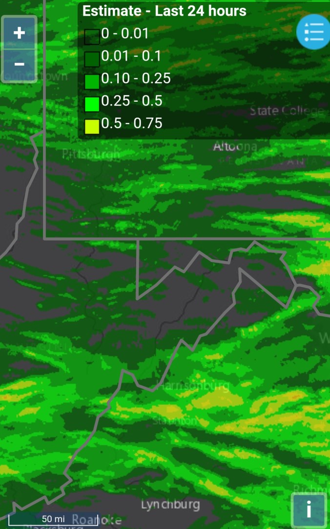
Radar(I picked up .25 since 6pm last night) Some areas around Canaan Heights, Davis picked up over 2″ last night. Some areas in western Tucker in lowlands had flooding. Amounts in these areas are greater than depicted by the estimate in the photo.
Satellite this afternoon
Flow
500mb anomaly
Current SST and 7 day change
Upcoming Heat Wave
Earlier in the week, I posted a list of expected temps based off model data. That still looks to hold on par for Sat-Mon, those days being the hottest but holding up beyond that. Here is the list
Johnstown Pa 88-93
Somerset Pa 87-92
Mt. Davis Pa 81-86
Grantsville Md 87-92
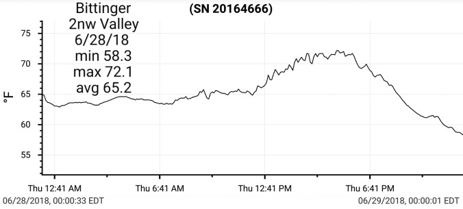
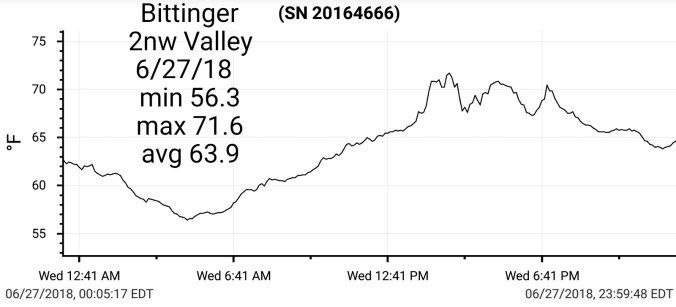
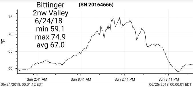
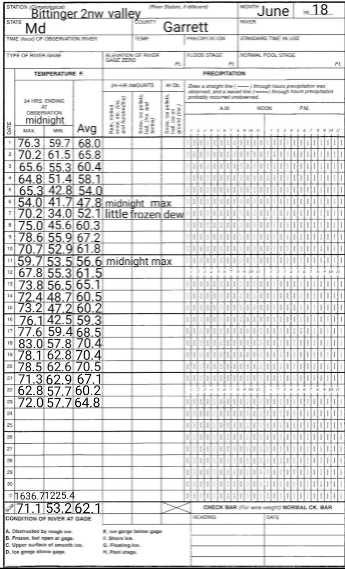
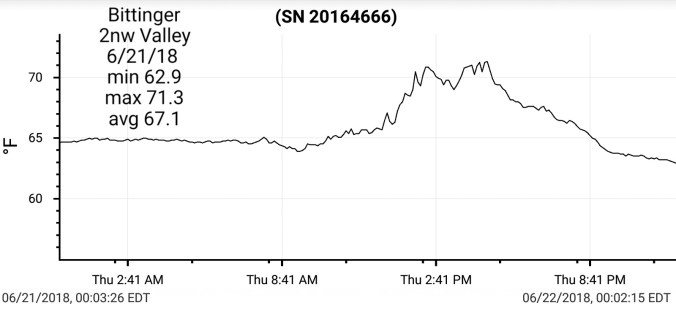
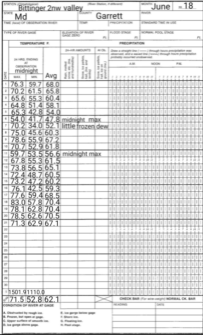
Bittinger Md 82-87
Accident Md 88-93
Friendsville Md 89-94
Mchenry Md 85-90
Oakland Md 89-94
Morgantown Wv 93-98
Cumberland Md 97-102
Keyser Wv 95-100
Parsons 91-96
Davis 83-88
Canaan Heights 81-86
Canaan Valley 82-87
Cabin Mt 78-83
Dolly Sods 80-85
Harman 85-90
Seneca Rocks 91-96
Spruce Knob 76-81
Elkins 90-95
Green Bank 88-93
Snowshoe 76-81
Marlinton 88-93
Cranberry Glades 82-87
** Car thermometers, bank/store thermometers will likely read higher than reality during this period. Lots of heat, radation reflecting back off artificial surfaces, objects.
Some numbers off todays 12z Euro Sat-Mon for Snowshoe area, Canaan area, Deep Creek area. Keep in mind, highest locations will run touch under these numbers, lower, town areas will top there numbers.
Mix of clouds and sun. Rain remained in southern Wv, and parts of Va.
Temp profile this afternoon
Radar
Satellite this afternoon
Flow
Looking Ahead at the incoming heat…
Friday through Monday, with Saturday through Monday being the most uncomfortable in terms of the combo of temps and dewpoints… max temp ranges look to max out in this range during that period
Johnstown Pa 88-93
Somerset Pa 87-92
Mt. Davis Pa 81-86
Grantsville Md 87-92
Bittinger Md 82-87
Accident Md 88-93
Friendsville Md 89-94
Mchenry Md 85-90
Oakland Md 89-94
Morgantown Wv 93-98
Cumberland Md 97-102
Keyser Wv 95-100
Parsons 91-96
Davis 83-88
Canaan Heights 81-86
Canaan Valley 82-87
Cabin Mt 78-83
Dolly Sods 80-85
Harman 85-90
Seneca Rocks 91-96
Spruce Knob 76-81
Elkins 90-95
Green Bank 88-93
Snowshoe 76-81
Marlinton 88-93
Cranberry Glades 82-87
In general, this period looks to be as hot as it generally gets in the area.
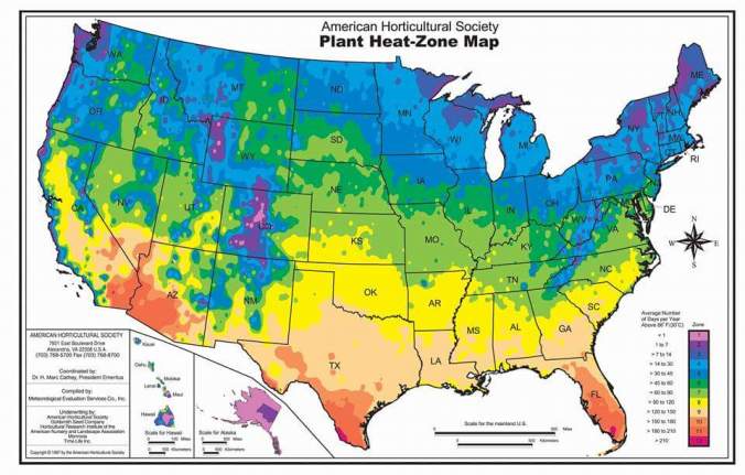
Typical days of +86 per year. (Map is not perfect, but a ballpark idea in area) In general the highest Wv spots rarely top 80.. Fair shot at that, this weekend.
** Car thermometers, bank/store thermometers will likely read higher than reality during this period. Lots of heat, radation reflecting back off artificial surfaces, objects.
Max temps off the 12z ECMWF with heat indecies Fri-Mon. The GFS has consistently been hotter than the ECMWF. What will likely occur is open, and town areas lean towards GFS, higher, wooded, rural areas lean towards the ECMWF.
Typical # of days of +86°
Looking further out, models are hinting at a July temp turnaround. Both the new Euro weeklies just in tonight and the CFSV2 evolve the pattern in a very similar way over the coming several weeks.
More clouds than sun, a few afternoon showers north. Rain, showers was more widespread south of Canaan through midday vs elsewhere.
Temp profile this afternoon
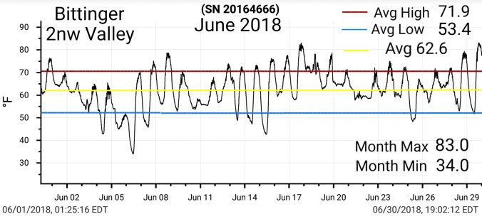
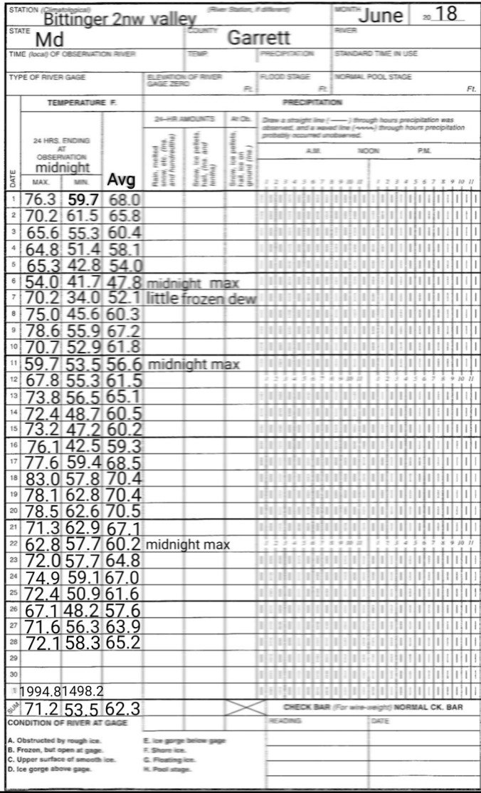
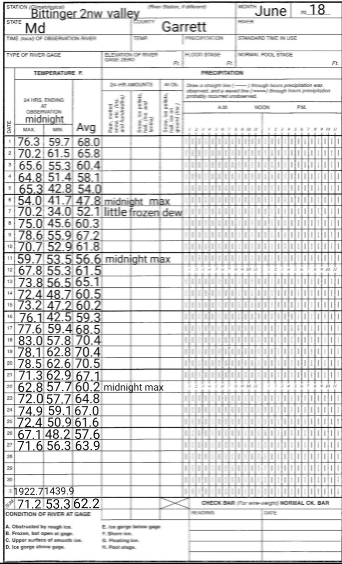
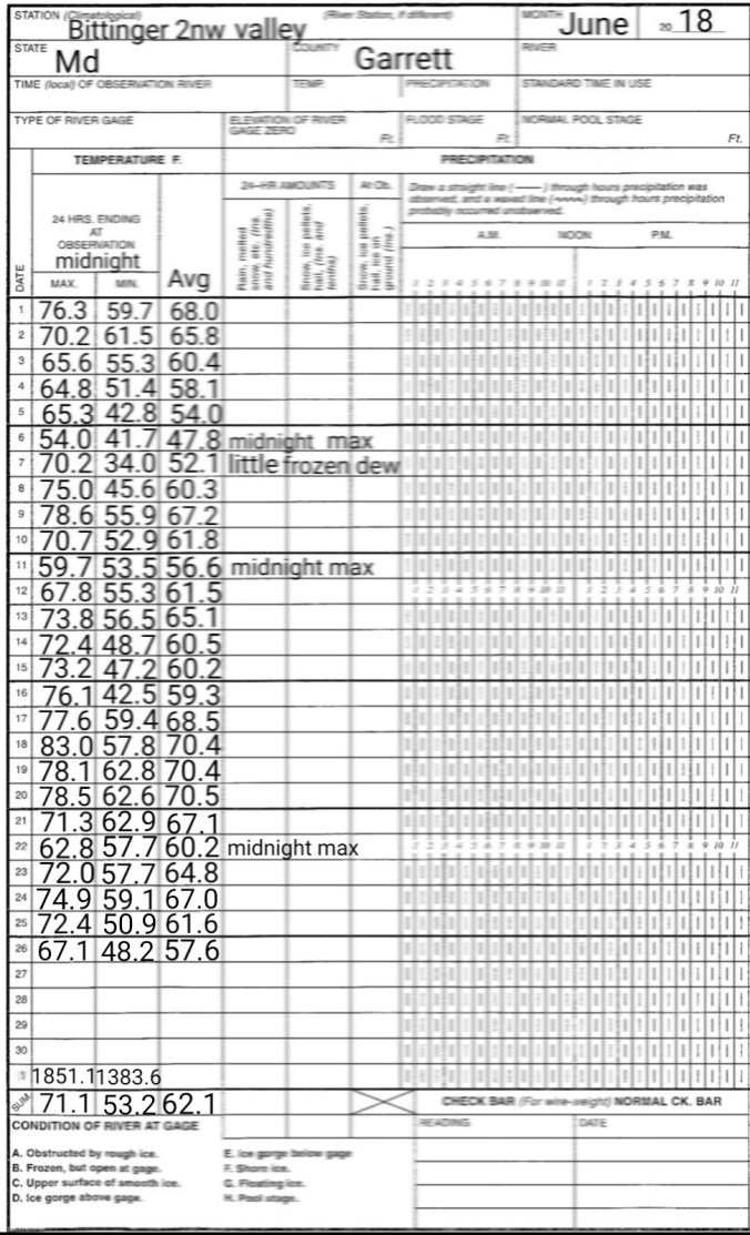
Month to date anomalies, colder vs average max temps, warmer vs average min temps, overall just +/- of normal on the month. Wv mts slightly above overall.
Cloudy, rainy, foggy, east wind was the dominant features. In some areas, periods of blue briefly occured, elsewhere it did not. A very chilly 1st full day of summer. Afternoon temps in the 50s, with winds gusting from the southeast 20mph to over 30mph at times.
Temp profile this afternoon
Radar past 24 hours
24 estimated rainfall
Flow this afternoon
Dominant east flow as seen in G.C.C wind chart
Satellite view this afternoon, evening
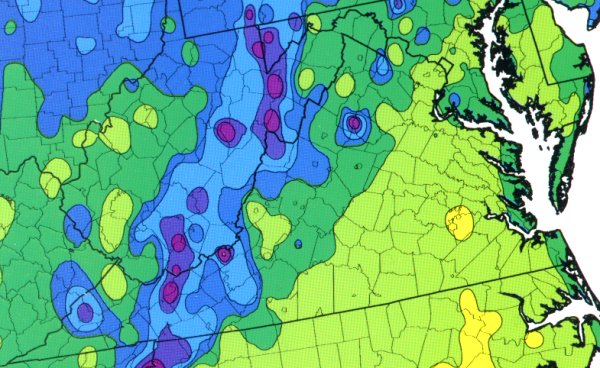
Year to date precipitation
Late Next Week Heat Wave??
A pattern like this, low pressures in the west, heights building in the east is a pattern to setup what can bring the hottest temps of the season. Models have a tendency to overdue this. Something to watch as we go into later next week, weekend.


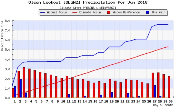
 PRECIP DATA:
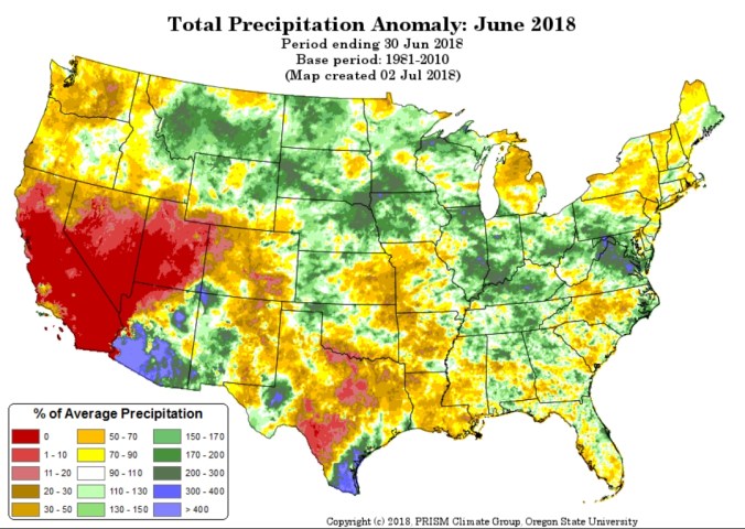


 Satellite this afternoon


 Radar(I picked up .25 since 6pm last night) Some areas around Canaan Heights, Davis picked up over 2″ last night. Some areas in western Tucker in lowlands had flooding. Amounts in these areas are greater than depicted by the estimate in the photo.


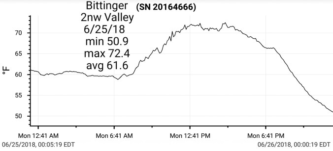
 Radar/estimated amounts. I picked up .4 at Bittinger 2nw Valley through 6pm with nearly all of that in the morning hours after dawn.
 Satellite this afternoon


 Radar
Radar


 Radar
Radar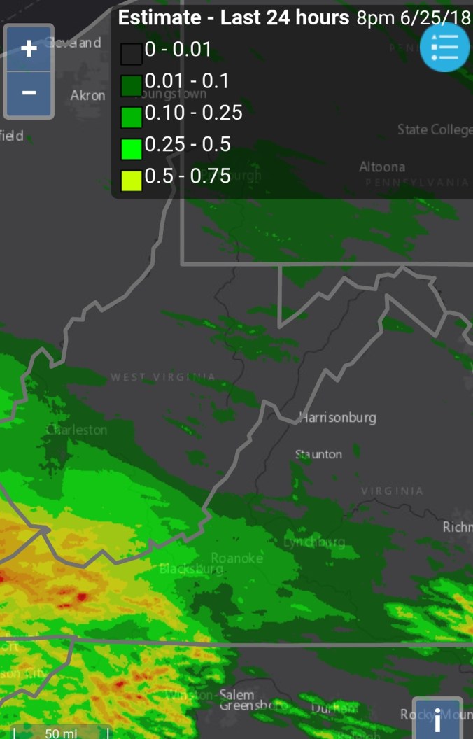 Satellite this afternoon


 Month to date anomalies, colder vs average max temps, warmer vs average min temps, overall just +/- of normal on the month. Wv mts slightly above overall.


 Satellite this afternoon


 Radar
Radar


 Radar past 24 hours
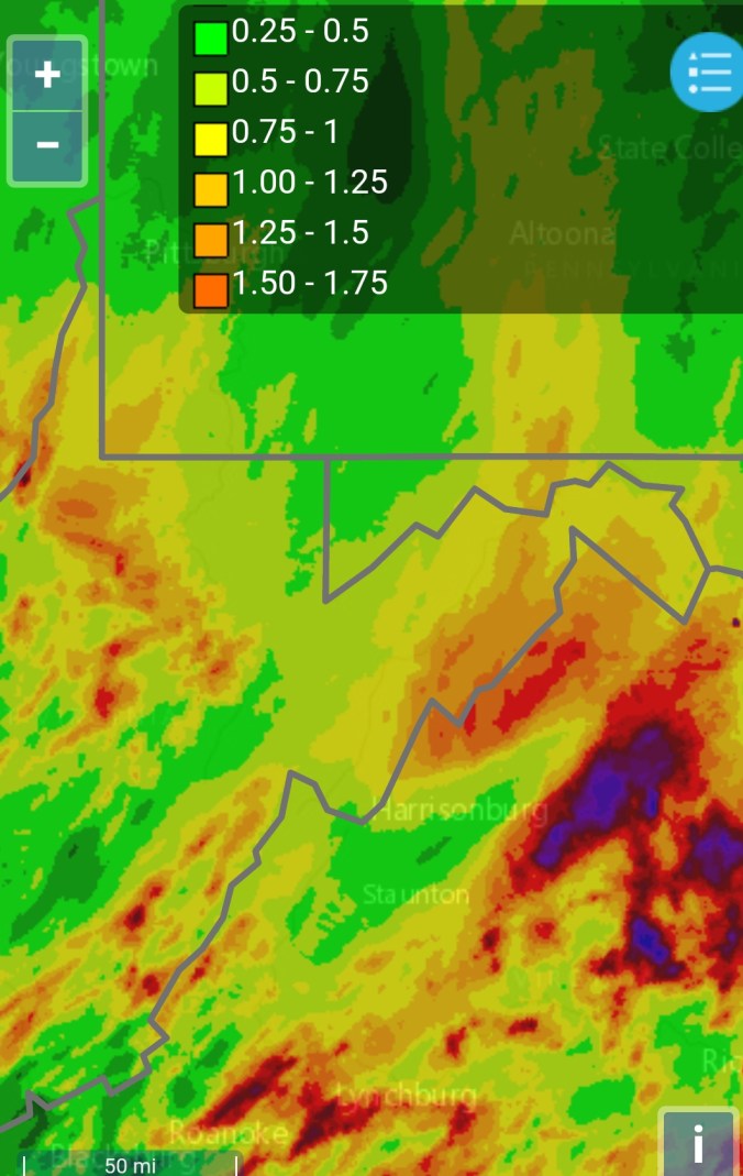


 Radar(I picked up .2 since 5:30pm last evening)

