Aug 28. min. max. avg
Bitt 2nw valley 59.1 81.1 70.1
Garrett College 65.1 83.1 74.1
Can-Heights 62.4 79.9 71.2
CRN-Canaan 63.4 79.8 71.6
Cabin Mt 63.3 79.0 71.1
Cabin Mt north 64.9 79.5 72.2
Spruce Knob 63.0 77.4 70.2
Snowshoe 65.1 74.5 69.7
Can-Valley Floor 51.6 81.9 66.7
7Springs 69.8 79.9 74.9
Mainly clear, hazy start, some pockets of valley ground fog. Few pop up clouds today. Warm, muggy. Showers mainly in parts of the southern Allegheny areas.
Temp profile this afternoon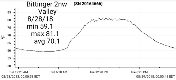


Radar with estimates 9pm-9pm
 Satellite
Flow
Surface features and 500mb height anomalies and flow


Smoke areas
18z 3km Nam
2m Temperatures
2m Dew Points
Simulated Radar
Warm and muggy continues, a slight(meaning not much) lowering of the dew points briefly Thursday night into Friday am. That better feeling air looks to hold just north of the region. Will need to watch the showers, storms into Thursday. Overall this pattern has 11-15 days of life as it appears now.
12z ECMWF meteogram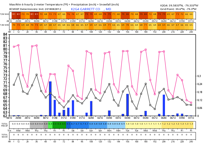
18z GFS meteogram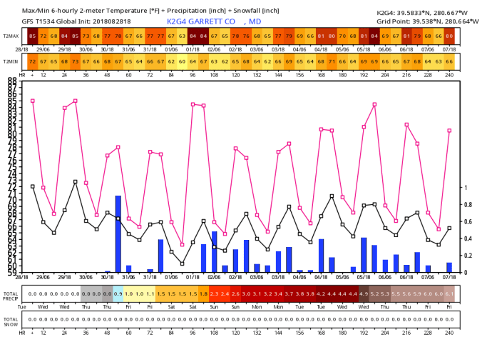
(keep in mind, this is based off one operational run, precip amounts can vary greatly run to run, 18z likely overdone on the GFS..time will tell)
18z run
Long range off a few models….Euro and CFSv2, looking like that 2nd week of September, a more fall like feel, and air mass will encroach on the east. A much welcomed shift vs the mugginess of present.
Modeled temp anomalies
CFSV2
Back to the Maples
Comparing the past few year…the 16′ pic is a few hundred yards up the road from the 17′ pic and todays pic. 2016 was took on the 29th of September, the 2017 pic the 14th of September, and 2018(today). Last year was a early change in areas with the chilly start to September. This area as well where these pics are, is typically a early changeover spot. A wetland area, trees often stressed, thus change earlier as well as nighttime mins are colder. This year however, and this is not limited to this location, or locations like this(meaning wetland) the maple leaf drop has been very noticeable. Some changed, and fell. Some fell while green. Along this portion, there is still some green, a little color, but a lot of foliage currently down…..


