Sept 11. min. max. avg
Bitt 2nw valley 57.0 64.5 60.7
Garrett College 56.8 65.4 61.1
Can-Heights 56.3 67.1 61.7
CRN-Canaan 56.5 69.6 63.1
Cabin Mt 56.5 65.5 61.0
Cabin Mt north 55.6 62.8 59.2
Spruce Knob 57.9 63.5 60.7
Snowshoe 59.2 67.1 63.2
Can-Valley Floor 58.5 73.0* 65.7
7Springs 54.2 60.0 57.1
Cloudy, some fog, drizzle and showers at times, but no precip quite often.
Temp profile this afternoon


Radar with estimates 9pm-9pm. Picked up .15 at Bittinger 2nw Valley
 Satellite
Flow
Surface features and 500mb height anomalies and flow


FLORENCE UPDATE
This afternoon, models came much more into agreeance. Whether this holds, remains to be seen obviously. The ridge is strong, and it appears this will shift the storm more west into the Carolinas, inland and up west of the mts. Well, what does that mean. It means not much rain in our area until early next week. For the Carolinas, it means they take a big wallop of the catastrophic level late Thursday night, through Saturday. This latest track(my gut thinks this holds) spares the words like, catastrophic, serious, in our area. Now, we still look to get rains as the remnants lift north. This looks like the type that can cause already high waterways to come out of their banks in spots, but not in a major way and not in anyway more than we have seen already. Areas north that saw the flooding this past weekend, I don’t currently see a repeat of that. Rainfall amounts are looking to be 1-3″, isolated higher, exception vs rule, if, and I stress IF things remain on this course. A slower movement, a quicker lift north could again alter that and increase these totals.
Here is a look at Florence today
Florence stats and NHC projection cone(notice the more southward turn in their cone)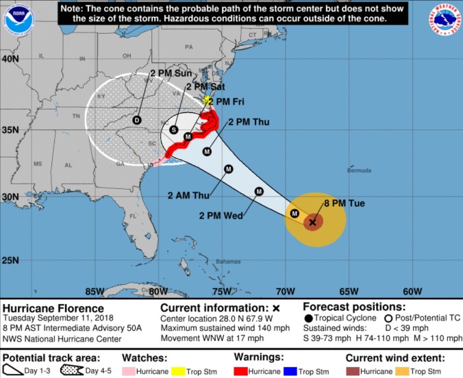
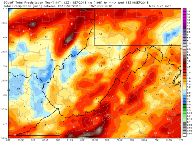
The 12z ECMWF precip type next 240hrs and amounts. Notice these amounts are through mid next week, because the remants pass Mon-Wed timeframe(precip totals also include some precip prior to the remnants, same as the GFS)
Lets look at the 12z ECMWF ensemble members on Low locations, thats a lot of agreement.
The 18z GFS, notice the similarity now to the 12z ECMWF, and amounts off the model.

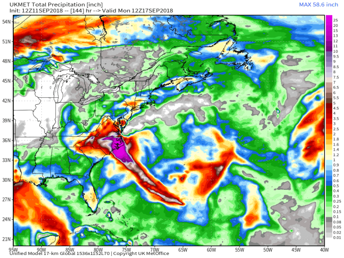
The 12z UKmet
Spaghetti Charts, that south trend, and the west path, theme of today and given the ridge north, seems legit.


A closer look in as the 18z 3km nam comes into range of landfall. 10m winds(not gust, gust will be higher at landfall)
