Sept 14. min. max. avg
Bitt 2nw valley 63.5 70.8 67.1
Garrett College 65.1 72.3 68.7
Can-Heights 62.7 69.9 66.3
CRN-Canaan 63.5 71.7 67.6
Cabin Mt 60.1 64.9 62.5
Cabin Mt north 61.2 65.1 63.1
Spruce Knob 61.2 63.3 62.2
Snowshoe 60.3 66.9 63.6
Can-Valley Floor 64.0 71.8 67.9
7Springs 63.0 69.8 66.4
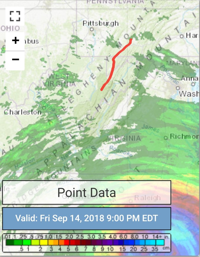
Drizzly, foggy, east flow, isolate brief peak of sun, 99% of the day was foggy, misty, drizzly. Temp max was with brief peak of sun. The eastern ridges of the Alleghenies were socked in with pea soup thick fog. Temps held 60s.
Temp profile this afternoon. Large difference in temps and conditions from east side of the Alleghenies to the downsloping valleys on the west.


Savage Mt to Morgantown today off cams


Pic by Steffi Hone on Spruce Knob
Radar with estimates 9pm-9pm, picked up .05 at Bittinger 2nw Valley… Radar and estimates misleading on this version. Lots of ground clutter near the radar sites. and the low moisture banking up the mts on the east side, noy detected. Leading to errors in radar estimates as well. Not that it rained a lot, but wet most of the day.
 Satellite
Flow
Surface features and 500mb height anomalies and flow


Florence
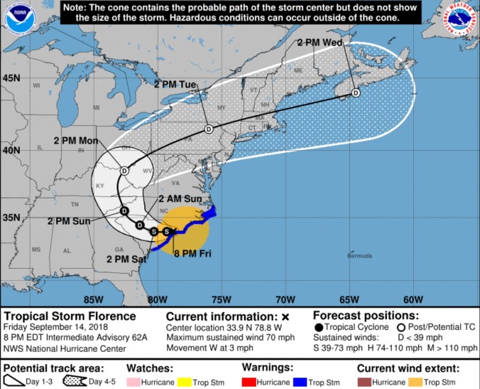
Florence estimates
on land, weakening, but moving slow and dropping lots of rain. Our rain looks to begin south to north late Sunday/ Sunday night, through Tuesday..Again, a tweak up in arrival and exit. Showers will occur over the time between now and then, especially the eastern ridges that were socked in the fog and drizzle today. Rain looks to be in the 1-3″ totals, with isolated higher amounts. Really riding the Euro(Ecmwf) on this. The GFS just looks odd. With a brunt of the precip occuring with S/Se winds, it makes 0 sense to dry out the downsloping areas on the east side of the Alleghenies like the GFS does, the ECMWF does the opposite.
12z ECMWF precip type next 240hrs, precip amounts through Florence remnants

The 18z GFS precip type next 384hrs with precip amounts only through Florence remnants

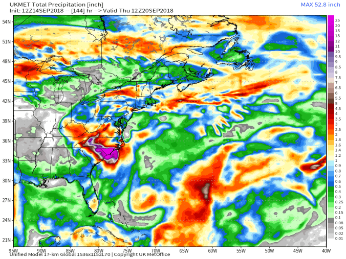
12z UKMET precip every 6 hours through 144 with amounts
Short term, again, not much flucuation in temps across the mts from night time lows to day time highs.
18z 3km nam 2m temperatures
18z 3km Nam Simulated Radar
Leaves……
Nope still here. The leaf season. This is setting up to be a funky fall foliage season. Mentioned in many post in late August if you were following about a fungal disease caused by the wet weather causing some tree types(especially maples) to drop leaves premature. Some leaves shrivle, some spot up, and hang on. Well that seems to have affected a portion, how much, depends on the area. Lots of those fell ,leaving primarily green maples with some color. I was walking around observing this evening, lots are on the verge of change across my area in Garrett County. I think the shorter days, and the cool down in max temps the last week after the very warm September start, and the constant cloud cover may be helping, but not as much if we would get some clear cold nights. They have been few in this overall wet damp pattern.. That said, this year vs last year on this date is very noticeable. Remarkably less color. Last year the maples went early, set off by a cold September opening and early frost. This year, that warm combo, with some early maple leaf loss, has left the early changers gone, and remaining mainly on the green side.


On the verge, I tend to think these will start to change fast despite the lack of cold temps in near term.


Last September start vs this year


32 between Davis and Canaan Heights on Sept 14 2014, vs today


Fungi amongi in all this wet weather


Not fungi, but I was amongI


