Sept 17. min. max. avg
Bitt 2nw valley 64.2 70.9 67.5
Garrett College 64.4 73.2 68.8
Can-Heights 60.9 70.6 65.8
CRN-Canaan 62.7 71.0 66.9
Cabin Mt 58.8 65.1 61.9
Cabin Mt north 59.5 68.9 64.2
Spruce Knob 58.8 64.0 61.4
Snowshoe 60.4 63.3 61.8
Can-Valley Floor 63.0 74.8 68.9
7Springs 62.2 68.2 65.2
Cloudy, rain, moderate to heavy in the a.m…some fog, drizzle, east flow.
Temp profile this afternoon


 Radar with estimates 9pm-9pm, .65 at Bittinger 2nw Valley
 Satellite
Flow
Surface features and 500mb height anomalies and flow


Last years start to September vs this year…
A much warmer front half of September this year, vs last year. Last years foliage season got kicked off rapidly across the high ground with the maples. This year, outside of the early season trees affected with anthracnose, we are lagging last year, but I would not say far off par for normal. The very warm start (front 7 days) to this September has helped the overall average on the month be well above normal, while the daytime maxes the past 8 days have been much cooler, in large part under a east flow, foggy, wet conditions in which may help aid in some color change. One big thing lacking, due to the cloud cover, wet conditions, we have had a blanket to prevent nightime temps from falling off this month. Last year we had some nice big chilly highs push in, clearing us out, letting temps fall. Not the case this year…..and to be honest, I don’t forsee this chance not until the last week of the month or into week 1 October.
At Bittinger 2nw Valley days 1-15 last year to this year. 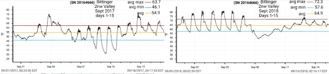
Max anomalies last year and this year


Min anomalies last year and this year


Overall average anomaly vs norms last year and this year


Precip last year for the month and vs norm


This year month to date and percentage of normal


On the models
Short term, showers tonight, into tomorrow. Coverage becoming less. Overall an additional .25 to .50 possible. Isolated higher amounts.
18z 3km Nam 2m temperatures
18z 3km Nam 2m Dewpoints
18z 3km Nam Simulated Radar
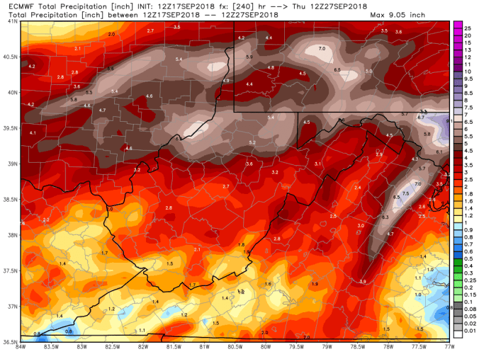
Longer term, upcoming weekend. Watching a stalled boundary with that being the focal point of possibly some more heavy rains. Will it set up in Pa, along the Mason-Dixon, or in Wv. That is a question. The 12z ECMWF was pretty hefty in the area it sets up. GFS not as much. Expect this too wobble north or south on the models over the upcoming week.
12z ECMWF precip type next 240hrs with precip totals through 10 days including tonights rain
18z GFS precip type next 384hrs with amounts through day 10.

