Sept 25 min. max. avg
Bitt 2nw valley 56.2 69.1 62.6
Garrett College 56.7 70.8 63.7
Can-Heights 55.5 68.5 62.0
CRN-Canaan 57.5 70.5 64.0
Cabin Mt. 53.4 66.2 59.8
Cabin Mt north 53.8 69.4 61.6
Spruce Knob 54.1 64.6 59.3
Snowshoe 57.0 61.7 59.3
Can-Valley Floor 56.1 74.3 65.2
7Springs 54.3 65.7 60.0
Rainy start, rainy morning, a mini break midday, early afternoon, rsin mid afternoon, early evening before quieting down.
Temp profile this afternoon


Radar with estimates 9pm-9pm. At Bittinger 2nw Valley, picked up 1.15 since last evening at 6pm… Garrett College 1.0, Canaan Heights .6, CRN .41, Cabin at Bald Knob .48, Northern Cabin Mt .6, Spruce Knob .18, Snowshoe .19, 7Springs 1.0


Satellite
Flow
Surface features and 500mb height anomalies and flow


On the models….
After a rainy day today, a mini reprieve before eyes go to the cold front tomorrow late afternoon or evening. This may contain some severe weather. Looks like the brunt stays north, but needs watched. Beyond that, a shot at some rsin Thursday night into Friday before “hopefully” a dry weekend for a change.
18z 3km Nam 2m temperatures
18z 3km Nam Simulated Radar
12z ECMWF precip type next 240hrs
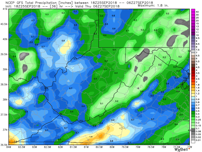
12z ECMWF precip through tomorrows cold front(*some of this afternoons rain included in this)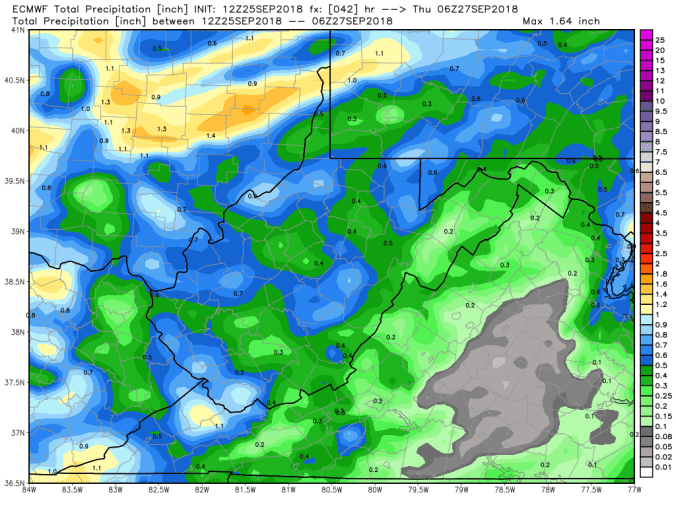
18z GFS precip type next 384hrs