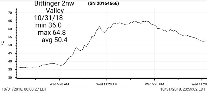
Some clouds early, then mostly sunny day. Light breeze.
Temp profile this afternoon
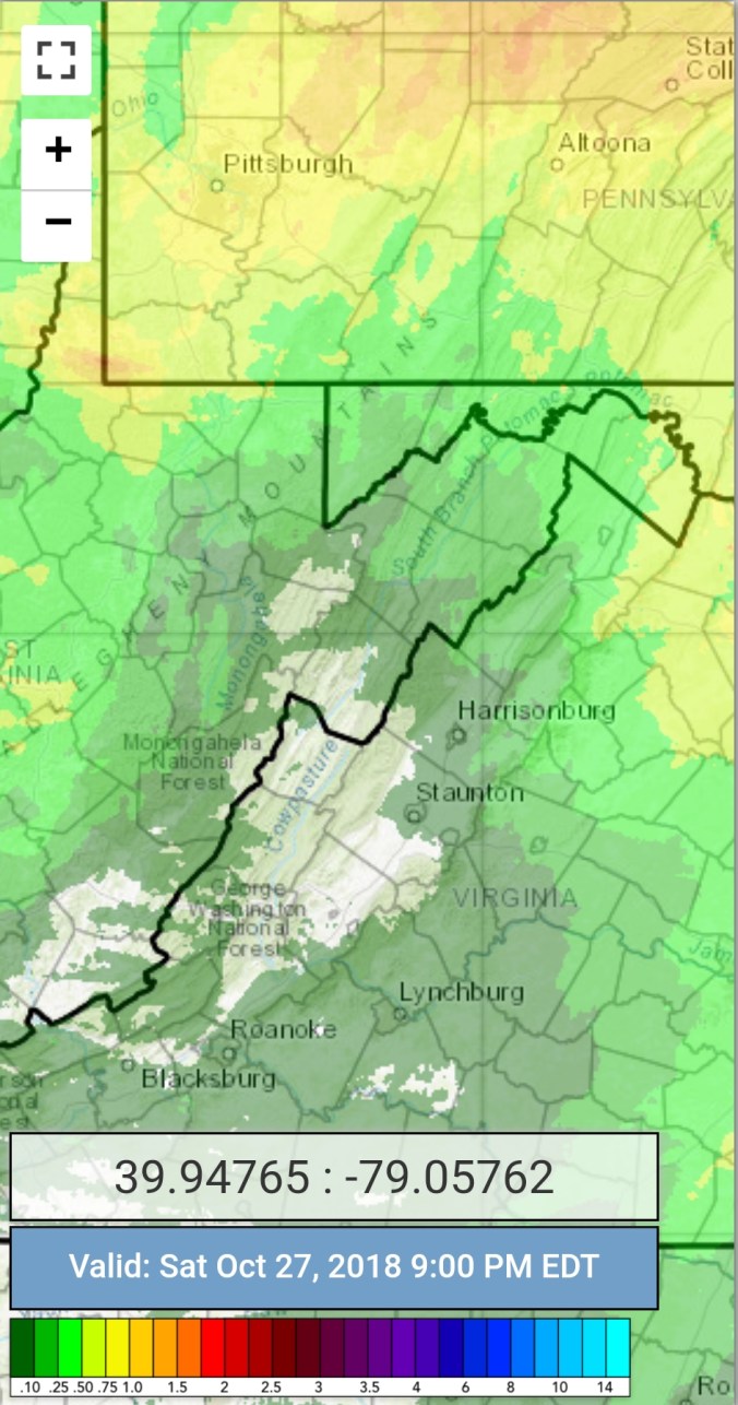
Rain ended pre midnight. From 6pm through midnight at Bittinger 2nw Valley I picked up .05.
Satellite
Flow
Surface features and 500mb height anomalies and flow
Pics on the day
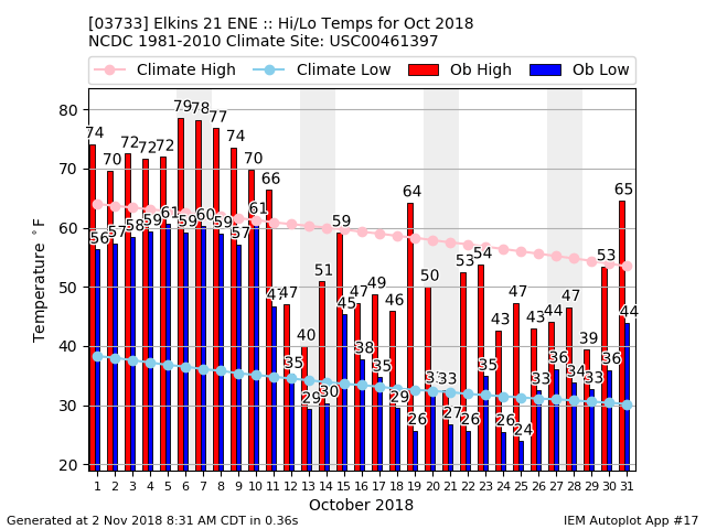
6 years ago as Sandy buried the area……
This time 6 years ago, thousands were out of electric, roads were closed and in some cases would remain so for the following week. Downed trees prevented roads from being opened quickly. The damage in lower areas where the wind did not blow the snow off of trees, as well as it was a degree or 2 warmer was extreme. In some areas trees fell like dominoes. Conifers in these areas tool a big hit. Lots of evidence of this yet today and years to come….
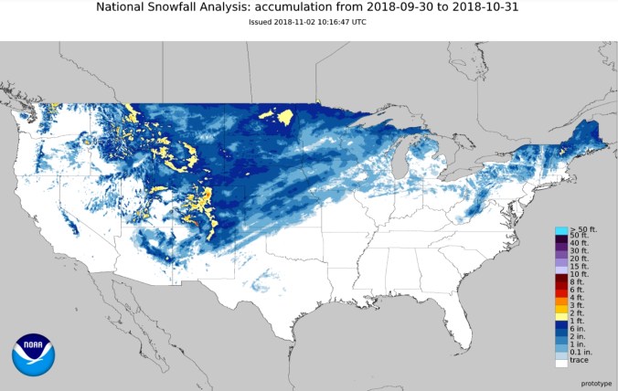
Modeled snow depths after Sandy
Pics from near Bittinger…..
Aftermath weeks later at Swallow Falls State Park. The hemlocks took a beating in this area.
Pics by Julie Hartman in the Swanton area.
Pics by Ryan Krempel at Deep Creek Lake area
Pic by Jerry Schlossnagle in Garrett County
Pics by Steve Emert in Crellin
Pics by Todd Romero of Sandy and the weeks after in Tucker County Wv
Pics by David Faunce around Davis, Thomas area
Pics by Sid Diamond in Canaan
Blackwater Falls damage and remaining drifts at Dolly Sods on December 6th after a mild November
Cloudy, times of showers, windy… Few ice pellets mixed in near Bittinger in the afternoon. Some fog as well today and in the Wv Mts, fog dominate for a large part of the day. Creating some rime above 4000′. *Snowshoe did some brief snow gun testing this afternoon….
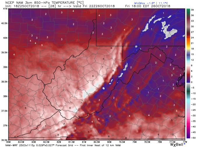
Temp profile this afternoon..
Radar with estimates 9pm-9pm. I picked up .7 at Bittinger 2nw Valley 6pm -6pm
Several day multi event totals..
Satellite
Flow
Surface features and 500mb height anomalies and flow…
6 years ago….
Sandy was making a big impact across the region 6 years ago tonight. Snow broke out across the Wv mts during the morning, I began seeing snow mid to late afternoon after a morning of rain. Perhaps the absolute worst call I’ve ever witnessed by the NWS calling for little to no accumulation within 12 hours of changeover and within 24 hours of 2-4 feet of snow. Snowfall rates were incredible. Snow density was unlike any snow I’ve ever seen. I drove on top of 2 feet of windblown new snow cover without sinking in. Trees began crashing about 9-10pm. Transformers on electric poles began blowing.
Will be posting more on Sandy tomorrow night as the damage was done.
First pic, the old Cherry Glade Church shortly after changeover. 10/29/12. Next pics the HRRR which did a great job in the short term. The Euro did fantastic in the mid and long range. Nam did well inside 84 hours. GFS totally flopped with this storm…..
Cloudy, showery throughout the day. Some fog. South of Garrett County, a period of sun occured this afternoon. Snowshoe woke up to a covering of snow. The co-op reported 1.0. I really wish they would put more effort to detail. Very poor. As it has been for years. Also some high elevation rime above 4000′. To end the day, some strong storms pushed through.
Temp profile this afternoon(maxes occured after)
Radar with estimates 9pm-9pm. Picked up .25 at Bittinger 2nw Valley 6pm-6pm
Satellite
Flow
Surface features and 500mb height anomalies and flow
On the models…
Showers overnight into Monday along with a colder push, aloft and the surface. Right off the bat, it appears the 3km nam is initializing with errors. I will post it, but as a model I am a huge fan on with the way it handles temps, it looks poor on the last few runs. As much as 8° off on hourly min on strong winds. The model usually is not that poor. That said. Showers look to mix with snow overnight above 3800′. Going to plain snow showers by daybreak tomorrow morning above 4000′. Colder air aloft works in through the day. Flakes may make it down to 2500′, but stickage remains above 3800′. Where a coating to a inch may be possible. Temps 30-34° tomorrow above 4000′ with windchills teens at times. 34-38° 3000-4000′ windchills low 20s. 38-45°,2000-3000′ windchills mid to upper 20s. Some rime may form across the high ground above 4000′ tomorrow, imo tomorrow night. May create some early Tuesday photography scenery up high, before things melt off.
Radar with estimates 9pm-9pm . Picked up .4 at Bittinger 2nw Valley since 6pm the 26th through 6pm tonight
Satellite
Flow
Surface features and 500mb height anomalies and flow
On the models….
Sticking short term. Light rain, mist, drizzle continuing overnight. Some fine flakes, rime , light icing may develop above 4000′. Another piece of energy drops in tomorrow afternoon. Initially re-warming the upper levels to provide straight liquid. As we go through Sunday night into Monday morning, as the system passes, colder air rushes back in Changes some liquid to some snow. . Marginal cold air, but cold enough a light coating up to a inch above 3700-3800’+ with the best and most likelihood above 4000′. Temps holding 29-33 above 4000′ Monday as temps fall from midnight maxes. Winds gusting 35-50mph above 4000′ with windchills 15-20. Elsewhere 36-40°Monday, wind gust 15-35mph and some flakes possible in the western upslopes down to 2500′ , no stickage. Windchills 20s.
Cloudy, strong east winds, precip breaking out during the morning south to north. Mostly light. Fighting the mid level dry air. Some icing occuring along the Allegheny Front. Spruce Knobs anemometer iced up at nightfall.
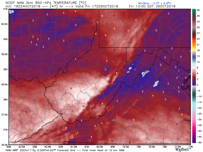
Temp profile this afternoon
Radar with estimates 9pm-9pm , . at Bittinger 2nw Valley through 6pm
Satellite
Flow
Surface features and 500mb height anomalies and flow
On the models….
Rain, wind, cold is the theme of the weekend. Late tomorrow, Sunday a.m, a few wet flakes may mix in.
Tonight temps hold 30s, strong east winds. Temps along the eastern Alleghenies above 4000-4200′ may hover near freezing for some icing. Fog as well across the high ground. Showers into Saturday, Saturday night. Saturday night may see a few wet flakes mix in above 2500′. Precip continues into Monday. One tweak to the original thinking is that the system exits late Monday, Monday night and clears by Tuesday allowing for a return and well deserved return to sunshine.
**using Snowshoe station at 4800′, other site still down.
Mainly clear start, some clouds pushing in shortly after daybreak. A high cloud deck worked in, in the afternoon.
Temp profile this afternoon
No precip
Satellite
Flow
Surface features and 500mb height anomalies and flow
Pics on the day
On the models…..
Precip pushing in tomorrow, looks light and increasing later in the day. This looks primarily in the rain form for most. Along the high areas of Cheat Mt, up the Allegheny Front, possibly along Dans Mt, Savage Mt also(less likely) a wintry mix may occur for later tomorrow afternoon into the early overnight. A likely difference from Bear Rocks to Cabin Mt. 1 or 2 degrees will make a big difference. Question is, is all areas above freezing or do these areas slip just below. This transitions to all light rain region wide after midnight into Saturday a.m. As the NW winds wrap back around, maybe some wet flakes at the highest spots later Saturday. More showers Sunday, Monday that again may end as flakes as it ends into Tuesday.
18z 3km Nam 2m temperatures
18z 3km Nam precip type
18z 3km Nam 850 temps later Friday
12z 2m temperatures
12z ECMWF precip type next 240hrs
12z ECMWF wintry precip
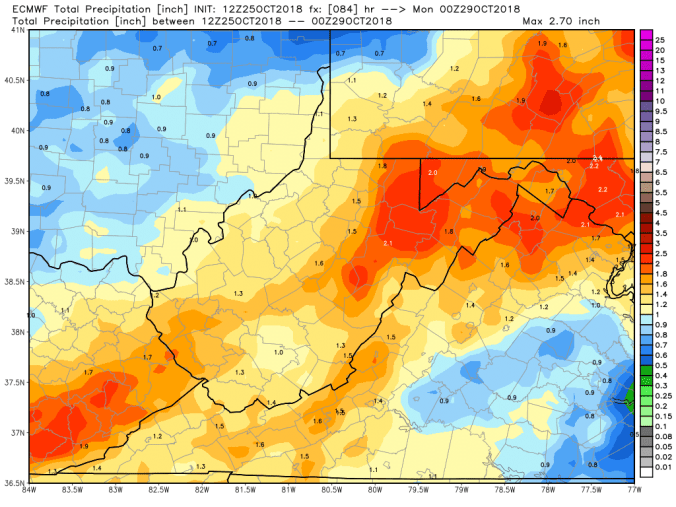
12z ECMWF precip totals through Sunday
Monitor some of the surface temps tomorrow after precip onset at Snowshoe, Spruce Knob, Mt.Storm, Savage Mt.
Surface features and 500mb height anomalies and flow
On the models….
Sticking short term. Precip pushing in Friday and running into the weekend. For most, its looking like a cold, check that, a miserable cold, rainy period coming up. As the rain pushes in Friday afternoon, there may be a brief mix shortly after the precip onset along the Allegheny Front. Wet Flakes, and or a little freezing rain before temps creep back up. The next piece of energy comes in Monday-Tuesday. That may end as brief snow across the mts.
18z 3km Nam 2m temperatures
18z 3km Nam precip type through Friday….hinting at a little wintry mix along the high ground of the Allegheny Front.
Mainly sunny day, few passing clouds. Windy afternoon.
Temp profile this afternoon
No precip past 24 hours
Satellite
Flow
Surface features and 500mb height anomalies and flow
On the models….
A developing Nor’Easter this weekend continues to adjust run to run on the models. It’s still early to make a clear cut call. Models have trended to this-
1- temps do look like the may be just mild enough for a cold rain event
2- a dropping upper level low may provide some wet snow early next week
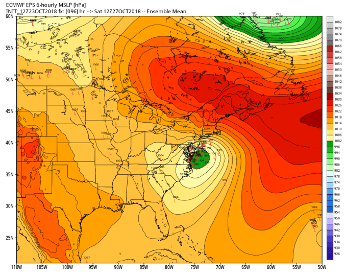
By no means is that etched in stone. Let’s look at the ECMWF low locations Saturday morning.. That doesn’t look like a lot, but it’s enough to play a big role in a borderline precipitation event.
Snowfall off the 12z ECMWF ensembles. It’s less than previous, but some members still see appreciable high ground snow with the event.
The operational ECMWF today has a odd scenario. Precip breaks out as snow and as precip builds heavier, it changes to rain in the high ground. That’s a red flag. The 12z ECMWF akso brings best accumulation with upper level low early next week. LOTS of tweaking and adjusting over the next 2 days
Mainly clear skies, only a few clouds today. Light breezes and low dew points. Those low dew points allowed the light snow covering today to remain on some north facing areas and shady spots. Many only look at temps when it comes to snow melt. You will melt more snow with temps upper 30s, with dewpoints upper 30s vs 50° and dry air.
Temp profile this afternoon with dewpoints
Dry period- no radar or estimates
Satellite
Flow
Surface features and 500mb height anomalies and flow
Pic by Jonathan Gladysz at Red Spruce Knob this morning
On the models…..
A developing nor’ easter this coming weekend. Track, intensity are HUGE question marks. Further east, weaker, its a light rain, rain, snow mix. West on the coast, and strong, more likely the mountains get an appreciable winter event out of this. Details are sketchy, confidence is low. So, keep this in the back of your mind that this potential exist for the weekend. Will resume graphics tomorrow..
The range of impact currently insignificant to major. The major impact would be a intensifying nor’easter, drawing in cold air, lift over mts, a wet heavy snow on areas where foliage remains. Oak areas, beech, lots of leaves on certain tree types, so power outage issues would occur under a scenario should this turn into a big ticket winter event. No hype, not saying its coming, not saying its not. Bottom line is, it is a unknown and lots of model variation.
Extended beyond, a shot of Indian summer may work in for early November.


 Radar with estimates 9pm-9pm
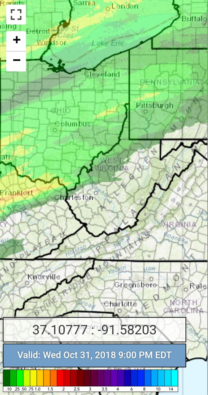


 Radar with estimates 9pm-9pm , . at Bittinger 2nw Valley through 6pm