Oct 17. min. max. avg
Bitt 2nw valley 36.7 51.5 44.1
Garrett College 37.8 51.9 44.8
Can-Heights 32.8 47.1 39.9
CRN-Canaan 34.7 48.6 41.7
Cabin Mt 30.6 43.5 37.0
Cabin Mt north 31.5 44.8 38.1
Spruce Knob 29.5 42.8 36.1
Snowshoe 32.2 44.8 38.5
Can-Valley Floor 36.0 49.8 42.9
7Springs 34.9 48.0 41.5
Mix of clouds and sun and windy would sum up today.
Temp profile this afternoon


No precip 9pm to 9pm,so take a look at the wind gust, over 50mph gust on northern Cabin, Mt Sods. The RTMA looks pretty good over the high ground.


Satellite
Flow
Surface features and 500mb height anomalies and flow


On the models…
The fun part. Cold night tonight, some places down to freezing or below for the first time. High ground has been there done that on numerous occasions. Chilly tomorrow, windchills 10-15 to start Wv high ground, 20-25 elsewhere, moderation of temps Friday, Saturday…then…
Some showers look to arrive Saturday, overnight those showers look to change to snowshowers into Sunday morning. Changeover first in the high Wv ground, then working down to around 2000’… Very early low confidence call. 2000-3000 coating to 1″, 3000-3500, 1-2″ 3500’+ 1-3″ . Above 3500′, temps will be well into the 20s, strong winds. That will quickly chill the uninsulated duff layer(leaves, grass, spruce needles, moss, etc) and snow will stick. The warm ground becomes more of a factor after 1-2″ accumulates, then that duff layer is insulated with snow and the ground warmth melts from undeneath. Below 3000- 3500, temps become more marginal, although the same principles, just a slower process to stick. Although a heavy burst can overcome that slow process. Monday morning, high pressures follows in the wake of the brief hit, that will lead to clear skies, and probably calm winds. Coldest high valleys Monday a.m could push 10-15° if skies clear, winds go calm. (Perfect setup could yield colder in those coldest pockets) Something to watch for. Most locations in the 20s.
12z ECMWF precip type next 240hrs
12z ECMWF 2m Temperatures
Heres the Monday a.m min off the 12z ECMWF. Not a strongsuit of the model. It does however see a little snowcover Sunday, into the night aiding the valley cooling. No snow, the model won’t show that low. Thats about the only time the ECMWF will model lower temps than the GFS is with snowcover. Also keep in mind, it’s a 9km grid model, it will not pick out valleys well. 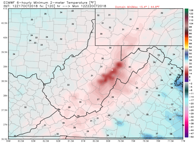
12z ECMWF windchills
12z ECMWF snowfall. Its the most robust of the models. The GFS though has slightly crept up, as well as the Canadian. The 12z ECMWF is backed by quite a few ensemble members. So the call is presently based off a blend of the models. 2 things also to hinder modeled totals. The very onset will take time to stick, and once it does stick, accumulate a little, insulates the duff layer. Warm ground will play a role,,especially in non windy areas. In windy areas, snow sticking to roads would be possible. I stress, 4 days out, low confidence in saying that. Just something to be mindful of come Saturday night, Sunday a.m. Photographers may have a morning to get some snow on some remaining foliage. Birches, beech still in the changing stage, maples done pretty well, oaks green with brown blotches. Oak is not abundant across the highest Wv areas. In areas with oak, accumulations look light enough no issues would occur.
12z ECMWF snowfall
