Oct 19. min. max. avg
Bitt 2nw valley 27.1 61.1 44.1
Garrett College 28.9 62.6 45.7
Can-Heights 27.9 61.8 44.8
CRN-Canaan 25.8 64.3 45.0
Cabin Mt 36 62.1 49.0
Cabin Mt north 33.1 62.8 47.9
Spruce Knob 35.6 61.0 48.3
Snowshoe 39.7 57.6 48.7
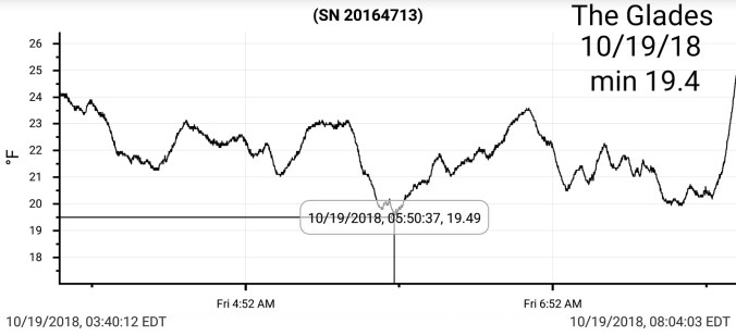
Can-Valley Floor 17.4 65.3 41.3
7Springs 35.4 56.5 46.0
Clear, start. Calm valleys, light southerly winds up high. Gave 20°+ temp swings from cold high valleys to high ground. Few clouds coming in during the afternoon and evening.
Temp profile this afternoon


 No rain, nothing on radar past 24, straight to todays satellite
Satellite
Flow
Surface features and 500mb height anomalies and flow


Pics today


On the models….
Showers pushing in late tomorrow, quickly changing to snow overnight. Some heavy burst possible. Strong NW winds. Falling temps. I would expect at the least, the exposed, windy areas will have some snow covered roads. Snowshowers in to Sunday a.m.
Keep in mind, nature of bands may leave areas in forecast zones less or more. Impossible to predict. While a area forecast of 1-2″ one area may end up with 2 or 3″ and pockets less than 1″ in areas that miss out on the precip bands. More of a guide than a rule with the event.
Latest thoughts and tweaks
1500- 2000′ coating to 1″
Sunday a.m temps 29-34°, windchills 15-20° Sunday afternoon 37-43° windchills 26-34°
2000-3000′ on the upslope areas of the Alleghenies. Coatings to 2″ . Tweaked upward with it looking to be a touch colder tomorrow night, and there may be a few narrow bands of heavy pockets of snow.
Sunday a.m temps- 25-32° windchills 10-15° Sunday afternoon temps- 32-37, windchills 21-26°
3000-4000′ 2-4″ of windblown snow. Gust 35-50mph.
Sunday a.m temps 18-24°, windchills 0-10, Sunday afternoon temps 28-33° windchills 15-20°
4000’+ 3-5″ of windblown snow. Travel will likely feature snow covered roads Sunday a.m. Sunday a.m temps 15-20°, windchills -5 to +5. Sunday afternoon temps 25-30, windchills 12-17
12z ECMWF precip type next 240hrs
12z ECMWF 2m Temperatures next 10
12z ECMWF snowfall 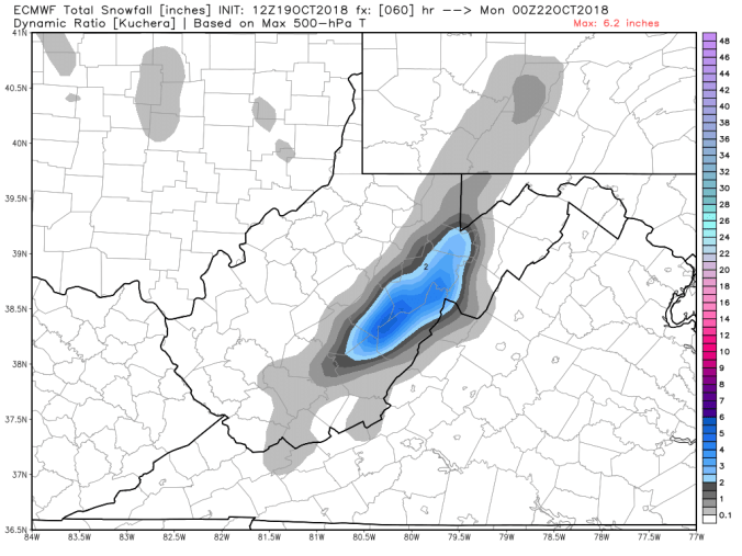
18z 3km Nam 2m temperatures
18z 3km Nam windchills
