Oct 23. min. max. avg
Bitt 2nw valley 36.0 55.0 45.5
Garrett College 38.2 54.8 46.5
Can-Heights 35.0 51.8 43.4
CRN-Canaan 33.7 53.7 43.7
Cabin Mt 31.1 49.8 40.4
Cabin Mt north 32.4 50.0 41.2
Spruce Knob 31.1 46.8 38.9
Snowshoe x
Can-Valley Floor 35.2 54.7 44.9
7Springs 35.5 50.1 42.8
Mainly sunny day, few passing clouds. Windy afternoon.
Temp profile this afternoon


No precip past 24 hours
Satellite
Flow
Surface features and 500mb height anomalies and flow


On the models….
A developing Nor’Easter this weekend continues to adjust run to run on the models. It’s still early to make a clear cut call. Models have trended to this-
1- temps do look like the may be just mild enough for a cold rain event
2- a dropping upper level low may provide some wet snow early next week
By no means is that etched in stone. Let’s look at the ECMWF low locations Saturday morning.. That doesn’t look like a lot, but it’s enough to play a big role in a borderline precipitation event. 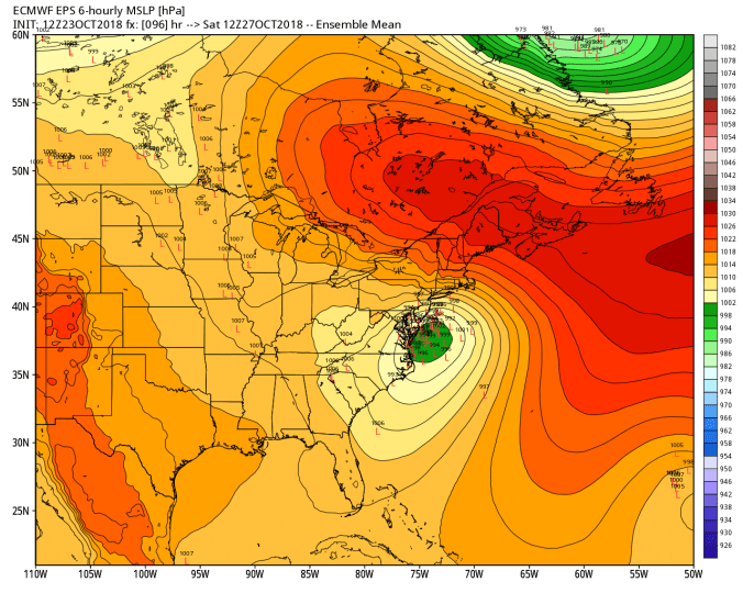
Snowfall off the 12z ECMWF ensembles. It’s less than previous, but some members still see appreciable high ground snow with the event.


The operational ECMWF today has a odd scenario. Precip breaks out as snow and as precip builds heavier, it changes to rain in the high ground. That’s a red flag. The 12z ECMWF akso brings best accumulation with upper level low early next week. LOTS of tweaking and adjusting over the next 2 days
12z ECMWF 2m Temperatures
