Nov 30 (Fri)             min.      max.     avg

Bitt 2nw valley      32.0       40.1      36.0

Garrett College      36.4       41.9     39.2

Can-Heights           33.7       42.9     38.3

CRN-Canaan           32.9      42.0     37.5

Cabin Mt.                33.6      40.1     36.8

Cabin Mt north     32.9      41.0     36.9

Spruce Knob         30.9      40.5     35.7

Snowshoe              36.9      42.4     39.7

Can-Valley Floor  34.3      44.1     39.2

7Springs                 33.0     39.2     36.1

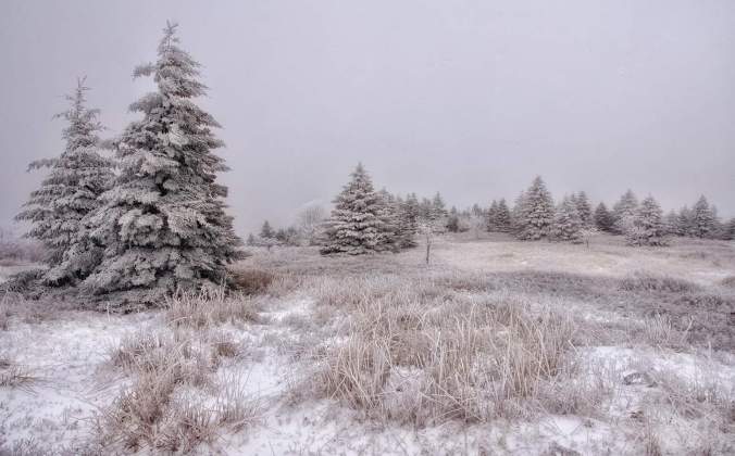
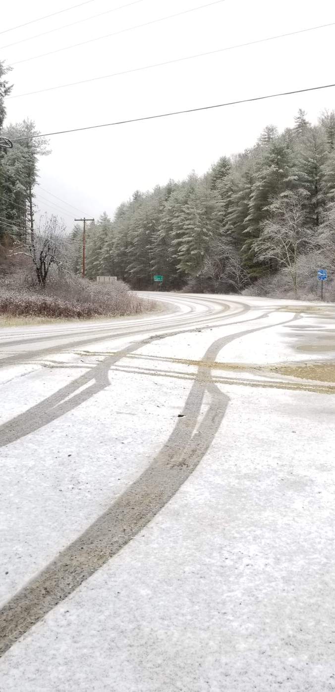
Cloudy, fog, mist, times of light rain. High dew points, light rain melting the snow off.

Temp profile this afternoon


2018-12-04-09-58-05Radar with estimates 9pm-9pm

Screenshot_20181130-213631

Satellite

Flow

Surface features and 500mb height anomalies and flow…


On the models…

Sticking near term.. Light drizzle, fog overnight. Northern Alleghenies cooling down well into the 30s by daybreak. Riding the 3km nam on this. It’s my live or die by model in these type of setups. The NWS forecast is much warmer. The GFS, ECMWF, are warmer than the 3km nam, but also a much wider grid. NWS forecast uses a airport grid. So, sticking with the 3km Nam.

That said, temps falling to around 30-33 in the coldest in the areas you’ll see in the graphics below. These areas have a shot at a little light icing tomorrow and temps holding near freezing through 2am-4am Sunday, before rapidly rising.  Ovenight tomorrow. Savage Mt may be 32° and holding while Terra Alta is 52°… that warm air mass will spread over all the area by daybreak Sunday. Widespread 50s across the area Sunday. We begin to chill back off Monday, and possibly some snow showers Tuesday/Wednesday. Right now, accumulations look very minimal if any.  Long range, storm signal for the 8th-9th period. Far too early to say on, if it develops, or where it tracks. But a time period to watch.

Now short term

18z 3km Nam 2m temperatures

closer look at around Garrett County where 3km has been persistent with temps just +/- freezing

18z 3km Nam Simulated Radar

November Summary

Temp Anomalies- Max/Min/Avg
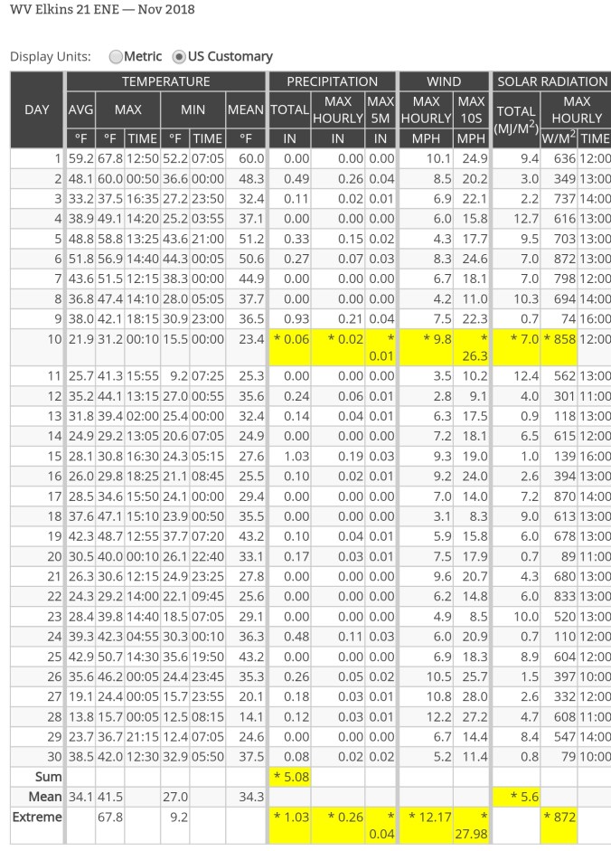


Screenshot_20181202-213913

Precip-


I finished with 5.2″ liquid with some estimated precip on the main winter event based off radar estimations, and nearby sites
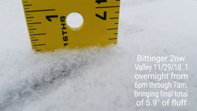


Snowfall-

I finished with 13.1″ on the month, elsewhere


Nov 29 (Thur)            min.     max.    avg

Bitt 2nw valley         16.3      32.0     24.1

Garrett College         16.4      38.6    27.5

Can-Heights              11.4      33.7    22.5

CRN-Canaan             12.4     36.7     24.6

Cabin Mt                   8.6       34.2     21.4

Cabin Mt north        9.9      33.3     21.4

Spruce Knob            6.8      31.6     19.2

Snowshoe                10.0     36.9     23.5

Can-Valley Floor     12.0     37.4    24.7

7Springs                   14.2     36.6    25.4

Cloudy start, few fine flakes, high ground fog. This quickly eroding by mid morning for a sunny late morning, through mid afternoon period. Then clouds building, and spotty light precip after dark. Some pockets of freezing precip, mainly north.

Temp profile this afternoon

Radar

Snowfall- Picked up .1 after 6pm last night through 7am. new SD dropped to 4.5″. That’s 5.9″ event total, 14.1″ season total2018-11-29-21-22-35

Satellite

Flow

Surface features and 500mb height anomalies and flow


Pics today


Pic by Vernon Patterson at Big Run FallsFB_IMG_1543533900029

Videos at Snowshoe and Canaan

On the models….

Spotty precip tonight, isolated pockets of freezing. Milder, low 40s tomorrow. Then, I have not seen any forecast remotely mention the threat of any spot seeing freezing rain Saturday. The NWS forecast for Garrett County didn’t mention temps in 30s even. I have said it before. I will live and die by the 3km Nam on this type of setup. 3km Nam is going with some light freezing rain in the same areas that got it last Saturday.  Warmer Sunday, turning colder Monday, light snow threat Tuesday

0z 3km Nam 2m temperatures

A look closer at the model at 11am, 3pm and 6pm Saturday, areas +/- 32 all day


0z 3km Nam Simulated Radar

A look at the freezing rain areas on the model. Ignore amounts. This is a weak link in the model. Location, strong suit. hires_frzrain_wv_61

Nov 28(Wed)              min.     max.     avg

Bitt 2nw valley         16.7   20.1(mn) 18.4

Garrett College         16.6    19.6       18.1

Can-Heights              11.2     14.9      13.0

CRN-Canaan            12.5      15.7      14.1

Cabin Mt.                  8.2       11.8      10.0

Cabin Mt north       9.5        13.3     11.4

Spruce Knob           6.6        10.0      8.3

Snowshoe                7.2        12.4     9.7

Can-Valley Floor   13.8       16.9     15.3

7Springs                 14.6       17.9     16.2

Snow, light fluff, sometimes lightly fallong, sometimes moderate, a few heavy pockets. Continuing the entire day through the 6pm obs. Becoming lighter at dusk.  Do note, western areas do best in this type of upslope. As the eastern areas(Finzel, Allegheny Front) does best with the coastal lows, and CAD(cold air damming) events, which we have seen some of already this season, the western zones do much better with upslope accumulation and it dies off as you go to the eastern zones.  Observe Northern Garrett vs Rt 40.   Highs occured at midnight.

Temp profile this afternoon/w windchills


Radar…again radar not picking up the high ground snow.

Snowfall- Bittinger 2nw Valley, 1.7″ overnight through 7am obs, an additional 2.0″ through 6pm boardsweep as some light fluff continued. Event total at 5.8″, avg new depth 5.1″. Season to date total at 14.0″ This in a fairly protected non windy area. Windier locations, depth is less as the wind helps blow about and break it down.


Canaan Heights- Picked up another 5.6″ overnight through today with an event total 8.2″, season to date 16.1″

Satellite

Flow

Surface features and 500mb height anomalies and flow


Pics today


Nov 27(Tues)         min.    max.    avg

Bitt 2nw valley      20.1     27.6     23.8

Garrett College      19.7    27.4      23.5

Can-Heights           15.0     23.1     19.0

CRN-Canaan          15.7     24.4     20.1

Cabin Mt.               11.8     20.5     16.1

Cabin Mt north     13.3     21.7     17.5

Spruce Knob          9.5      19.6      14.5

Snowshoe              9.5      19.4      14.4

Can-Valley Floor  16.9    25.5      21.2

7Springs                17.9    24.6     21.2

Cloudy, light snow showers for duration of the day. A brief period of light freezing drizzle in the mix at daybreak. Best snow activity after dusk. Windy and cold

Temp profile this afternoon

Radar, no estimate map as radar fails to pick up on high ground snowfall

Snowfall-  Bittinger 2nw Valley 1.3″ overnight, .7″ today, on top the .1 last evening prior to 6pm for an event total through 6pm of 2.1″. Heavy burst after 6pm.  10.3″ on the season


Canaan Heights at 4.2″ event total through 7pm

Satellite

Flow

Surface features and 500mb height anomalies and flow


Pics today


Pic by Vernon Patterson at Bald KnobFB_IMG_1543362350671

Nov 26(Mon)             min.    max.     avg

Bitt 2nw valley          27.6      44.3     35.9

Garrett College         27.4      46.3     36.8

Can-Heights              23.3      44.1     33.7

CRN-Canaan             24.4      46.2     35.3

Cabin Mt.                  20.7      40.8     30.7

Cabin Mt north        21.7      43.0     32.3

Spruce Knob            19.6      37.4     28.5

Snowshoe                 19.2      38.1     28.6

Can-Valley Floor      25.5      46.9    36.2

7Springs                    24.6      43.8    34.2

Cloudy, showery morning. Brief glimpse of sun. Changeover to snow by midday to early afternoon south to north. I had flakes prior to 2pm. Falling temps

Temp profile this afternoon…


Radar with estimates 9pm-9pm , picked up .4 at Bittinger 2nw Valley

Screenshot_20181126-210655.jpg

Snowfall: Bittinger 2nw Valley  .1 through 6pm 8.3″ season total

Satellite

Flow

Surface features and 500mb height anomalies and flow…

Pics today…


Upcoming quick thoughts….

Snowshowers on and off through Wednesday. 3-6″(fluff) totals through the region with the western upslope zones more favored. Temps mins 5-10 4000’+, windchills bottoming out 5 to 10 below tonight, 10 to 20 below tomorrow night. Highs 14-20, 2000-4000, temps  12-20 for mins, 20-30 for maxes, windchills 0-10 tonight -10 to +5 tomorrow night.

Nov 25 (Sun)            min.     max.     avg

Bitt 2nw valley       32.3      48.8      40.5

Garrett College       36.3      51.3      43.8

Can-Heights            35.7      47.5      41.6

CRN-Canaan          35.6       50.7      43.2

Cabin Mt.                35.4      46.2      40.8

Cabin Mt north     36.5      46.0      41.2

Spruce Knob          33.4      42.6     38.0

Snowshoe               34.2      46.9     40.5

Can-Valley Floor   31.1      52.1     41.6

7Springs                 39.4      47.1     43.2

Cloudy start, sunny mild afternoon

Temp profile this afternoon…


precip ended last evening

Satellite

Flow

Surface features and 500mb height anomalies and flow.


On the models…

Showers pushing in late tonight into Monday, transitioning to snowshowers by the afternoon. Some moderate and maybe even a few heavy squall Monday night. Snowshowers look to continue in an on and off fashion through Wednesday. Monday p.m through Wednesday p.m total look to be in the 3-6″ range of fluff with some favored areas exceeding 6″.

12z ECMWF 2m Temperatures

12z ECMWF precip type 11/25/18

12z ECMWF Kuchera Ratio Snowfall through Thursday a.m. ecmwf_tsnow_KU_wv_18

Nov 24(Sat)             min.     max.     avg

Bitt 2nw valley       25.1      41.1     33.1

Garrett College       25.8       42.9     34.3

Can-Heights            35.3       40.3     37.8

CRN-Canaan           30.3       42.3     36.3

Cabin Mt.                32.7       37.4     35.0

Cabin Mt north     32.2       38.8     35.5

Spruce Knob         27.1       36.0      31.5

Snowshoe             26.1        36.5     31.3

Can-Valley Floor  27.0       43.9     35.4

7Springs                22.8       40.5     31.6

Precip onset around daybreak. Steady freezing rain across the traditional areas that hold onto the cold in this type of setup. At Bittinger 2nw Valley, this continued until nearly midday, wutg temps holding 32.1- 32.7 until 8pm in the valley. Longer east towards Savage Mt and east and less west, where really no freezing rain fell, as well as at Canaan. Milder event in those spots. Some pockets of sleet along Savage Mt observed and some pockets of snow in Pocahontas County.

Temp profile this afternoon


Radar ,  picked up .6 at Bittinger 2nw Valley


Satellite

Flow

Surface features and 500mb height anomalies and flow…..


Pics today…..


Pic and Video by Jeremy Cutlip near Bartow where a burst of snow occured todayreceived_456489301546433

Some Flakes flying at Snowshoe in that time. A little hard to see on video

3km Nam actually showed pockets of snow occuring. These setups are the strongsuit of this modelhires_snow_wv_25

Nov 23(Fri)             min.     max.     avg

Bitt 2nw valley      17.2       32.0     24.6

Garrett College      17.3      35.0     26.1

Can-Heights           20.5      39.5     30.0

CRN-Canaan          18.5      39.8     29.1

Cabin Mt.                23.0     37.8     30.4

Cabin Mt north     14.4      37.9     26.1

Spruce Knob          20.3     34.0     27.1

Snowshoe                22.8    32.4    27.5

Can-Valley Floor    14.2     42.4    28.3

7Springs                   15.4    29.8    22.6

Partly to mostly sunny skies, SE flow…. high thin overcast later in the day. Much warmer west side of the mts.

Temp profile this afternoon


Radar void of precip

Satellite

Flow

Surface features and 500mb height anomalies and flow.


Pics today

2018-11-23-18-05-36

Pic by Jeremy Cutlip of Sharp Knob above Marlinton todayreceived_199639124288433

Snowshoe day #3 of skiingScreenshot_20181123-175314

Photos from Black Mt along Highland Scenic Highway today


On the models…..

Cold dry air in place over parts of the area. The traditional zones that hold on to cold air the longest. Cheat Mt and east in Pocahontas over into Bath, up and just east of the Allegheny Front, then to 219 at Sand Flat north and east in Garrett County, and up the Savage Mt ridgeline and just east. The 3km Nam is usually very good in these setups. These setups usually feature some mild air getting into Canaan mucg earlier thab many other spots in the Alleghenies.

Here is the

12z 3km Nam 2m temperatures

12z 3km Nam precip type

Poor efforts at the Wisp

While they have made snow, they once again at 7:30pm tonight are not. The half hearted effort and no effort is why they remain no where near being open while other resorts in the area are. 7:30pm conditions and Wisp


                  Thanksgiving Day

Nov 22(Thurs)       min.      max.     avg

Bitt 2nw valley     18.2     25.6(mn)21.9

Garrett College      18.9      26.7      22.8

Can-Heights           20.3      26.6      23.5

CRN-Canaan          22.1     29.2      25.6

Cabin Mt                18.3     26.2      22.2

Cabin Mt north     14.0     23.2     18.6

Spruce Knob         18.1     23.5     20.8

Snowshoe              22.1     27.5     24.8

Can-Valley Floor  22.8      30.9    26.8

7Springs                11.9      18.7    15.3

Mainly cloudy skies, some areas of sun north and south. I held consistently cloudy. Cold day as well.

Temp profile this afternoon


Radar- pretty well void of precip. Squall line last night fell apart. Limited to a few flakes.

Satellite

Flow

Surface features and 500mb height anomalies and flow


Snowshoe today with Thanksgiving skiing

Nov 21(Wed)          min.    max.     avg

Bitt 2nw valley       25.7      32.2     28.9

Garrett College      26.6      31.4     29.0

Can-Heights           23.1      28.7     25.9

CRN-Canaan          24.9      30.6     27.8

Cabin Mt.               20.3      27.3    23.8

Cabin Mt north     21.0      25.9    23.4

Spruce Knob         19.2      26.2    22.7

Snowshoe              19.6     26.2     22.9

Can-Valley Floor  25.9     33.4     29.6

7Springs                18.7      25.2    22.0

More clouds than sun at daybreak, skies broke through late morning, before a lowering cloud deck pushed in midday, and pressed south into WV in the afternoon. Accompanied by some fine flakes and a light trace of freezing drizzle. (Rt 40 cam shows a good example of this as it faces NW)

Temp profile this afternoon


Radar with estimates 9pm-9pm… very light precip not showing on radar

Screenshot_20181121-211452

Satellite

Flow

Surface features and 500mb height anomalies and flow


Pics today


opening day at Snowshoe


Wisp finally making snow tonight

Pic by Vernon Patterson on Cabin MtFB_IMG_1542843990184

On the models….

Using the 3km Nam for temp setup through Saturday a.m. Outside of patchy light, scattered pockets of snowshowers tonight and tomorrow, the big story is colder temps. Especially Tucker and northward. Then we set up the classic cold high north, east wind scenario. Cold in central, eastern Garrett, mid to upper 20s Friday, 44-48 in Morgantown… Some mildaur, as usual bleeds in to Canaan. I’d suspect they stop snow making on Friday due to that. Wisp should be good until overnight Friday into Saturday a.m. Snowshoe as well. Early Saturday, some light mix possible. Possibly until midday in coldest spots..

0z 3km Nam 2m temperatures