Nov 5(Mon) min. max. avg
Bitt 2nw valley 40.8 52.3 46.5
Garrett College 41.0 55.9 48.5
Can-Heights 42.3 57.5 49.9
CRN-Canaan 43.6 58.8 51.2
Cabin Mt. 37.6 55.8 46.7
Cabin Mt north 38.3 56.3 47.3
Spruce Knob 37.0 52.7 44.8
Snowshoe 37.9 52.9 45.4
Can-Valley Floor 31.8 61.2 46.5
7Springs 38.6 52.0 45.3
Rain overnight, early a.m. SE flow at surface, fog along eastern ridges. Mainly cloudy, brief peaks of sun. More sun west. Canaan west sun, western Garrett more sun vs east
Temp profile this afternoon, also 3km Nam that looks more like reality than the RTMA. Also included fog areas off the 3km nam that did well. Refer to pics to see some of the fog spots.


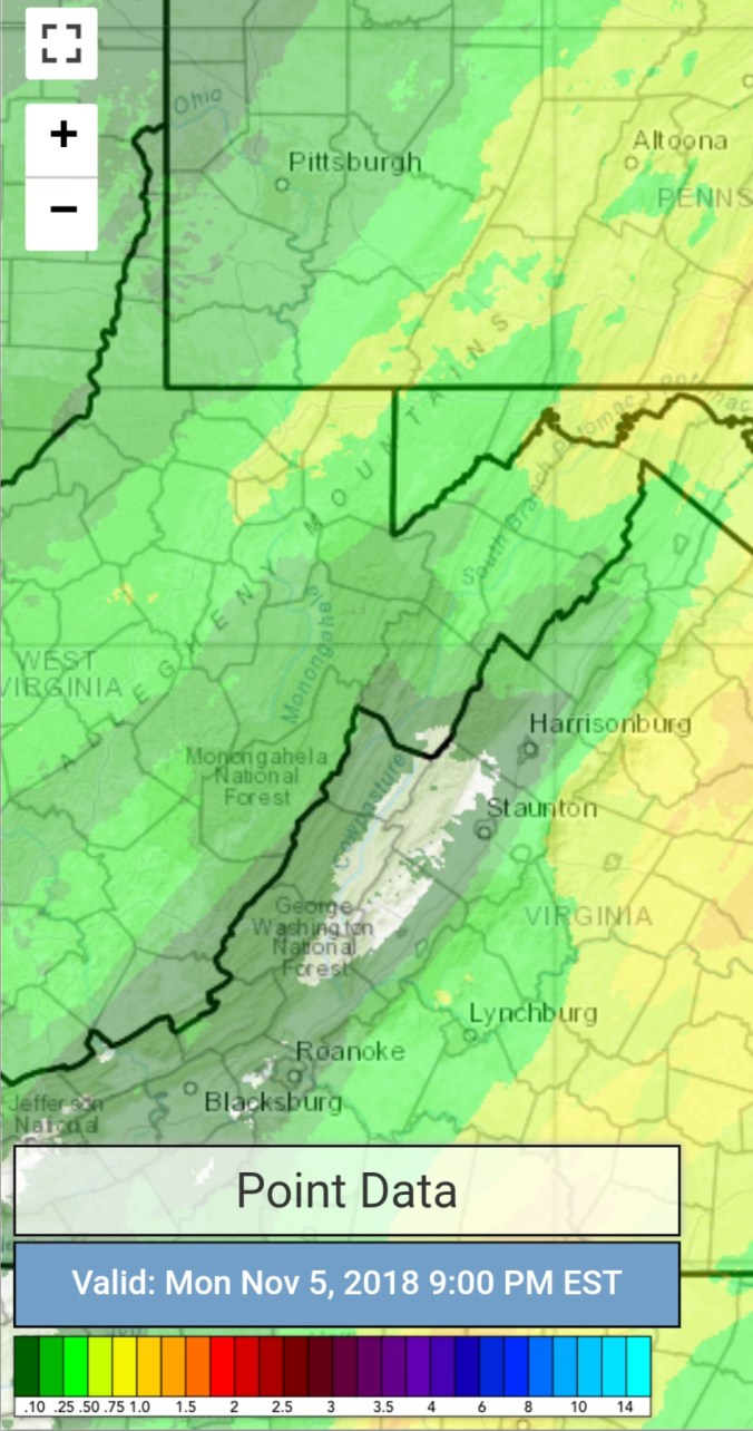
Radar with estimates 9pm-9pm. Picked up .45 at Bittinger 2nw Valley
Satellite
Flow
Surface features and 500mb height anomalies and flow


The Fog… in Garrett the difference from Savage Mt to Keysers Ridge is generally great in this setup..today no different


The fog across Cabin Mt was impressive and cool
The northern end of Cabin was more impressive . I took the first 2 pics around 1:30pm. Dave Lesher took the 3rd one a little bit later. You can see advancement. Also on cam how long it took to come across southern Cabin.


Pics today


Canaan Mt tranquillity
On the models….
Short term, watching line of strong storms set to move through around daybreak. Biggest risk, downpours, strong winds embedded within the storms.


Further out, colder air works its say in, some cold rain late week, mixing with snow Saturday….then we watch to see how much cold pushes and where the storm track sets up. Going into a winter like pattern for Mid November
18z GFS 2m temperatures
18z GFS precip type
