Nov 12(Mon) min. max. avg
Bitt 2nw valley 21.6 40.3 30.9
Garrett College 22.9 43.7 33.3
Can-Heights 31.6 43.8 37.7
CRN-Canaan 27.0 44.1 35.6
Cabin Mt. 32.0 41.5 36.7
Cabin Mt north 28.8 42.4 35.6
Spruce Knob 30.6 39.2 34.9
Snowshoe 28.8 41.9 35.3
Can-Valley Floor 19.2 46.4 32.8
7Springs 29.3 41.1 35.2
Cloudy, light SE flow. Very dry mid to low levels. Cloud deck lowered, radar began showing precip in the afternoon, mainly virga(Not reaching the ground). Temps rose upper 30s, low 40s..dewpoints in the 20s. As precip began and low levels became saturated temps fell off into the low 30s. Some ice pellets and a little freezing in the trees..
Temp profile this afternoon, temps fell off with precip entering from this point


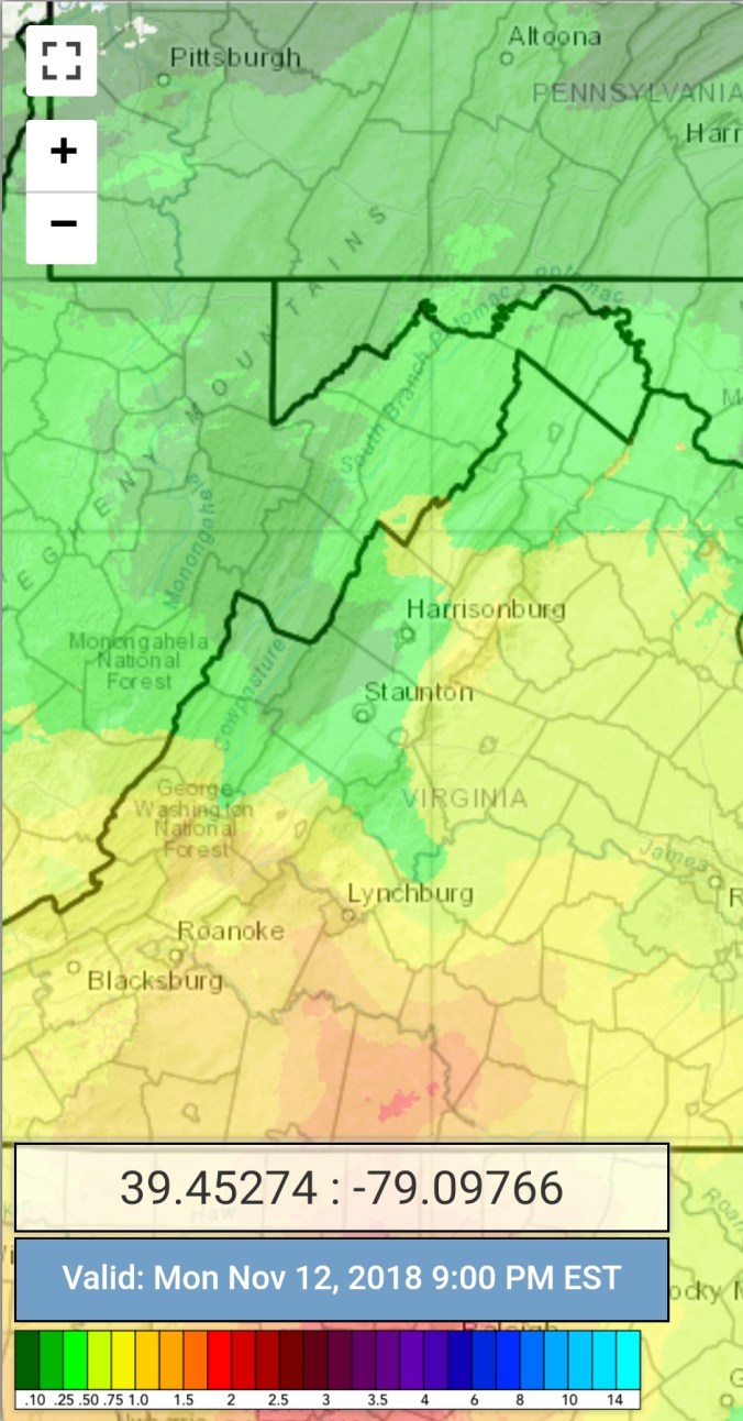
Radar with estimates 9pm-9pm. Once again poor radar estimates. These estimates look to be showing more hitting the ground vs reality
Satellite
Flow
Surface features and 500mb height anomalies and flow


Snowshoe this morning..very dry air in place aided snow making, especially at the base where it was colder vs the top.
On the models….
Light precip tonight, that has had some light freezing rain, ice pellets, flakes north, and plain rain continues into tomorrow morning where it changes to lighy snow. Coating to inch maxes…bigger event Thursday. Precip type will vary on location. Right now a fairly significant icing event, with sleet as well with 4+” of backend snow look possible. Timing, strength, track will ultimately determine precip type, amount
12z ECMWF precip type next 240hrs
