Nov 14(Wed) min. max. avg
Bitt 2nw valley 21.8 31.4 26.6
Garrett College 21.6 31.9 26.8
Can-Heights 19.8 26.6 23.2
CRN-Canaan 20.6 29.2 24.9
Cabin Mt 17.1 25.0 21.0
Cabin Mt north 17.8 24.3 21.0
Spruce Knob 15.8 26.4 21.1
Snowshoe 16.3 30.9 23.6
Can-Valley Floor 22.1 31.3 26.7
7Springs 18.3 24.7 21.5
Partly cloudy start after some light freezing fog, light coating of snow in some wv high ground overnight, patchy freezing drizzle in pockets as well. High thin overcast begin moving on this afternoon, with a sundog around the sun. To note, light icing,(from 2 days ago and last night) with a little rime from last night remained on trees in Garrett above 2750 all day. Wv high ground timed in today.
Temp profile this afternoon


Radar estimates…radar nor estimates picking up on the light precip estimates 9pm-9pm(Radar not picking up on the light Mt precip last night)
Satellite
Flow
Surface features and 500mb height anomalies and flow


Pics on the day


Pics by Vernon Patterson at Bald Knob and Canaan ski area


Pics posted on Canaan Valley National Wildlife Refuge page by Dawn Washington


Pics by David Faunce at Blackwater Falls State Park sled area making snow


Snowshoe this morning
Canaan Valley Ski Area this morning
Storm outlook
Posted this to Facebook:
Not a big fan of the hrrr, but I think it sets a great example of boundary setup for this event. This is precip type at 8am tomorrow. I think ultimately, it can be used for primary precip type setup for duration of the event.
If you live in Garrett County, often in these setups, there is a finger of cold near Sand Flat Rd, and a difference from there to Oakland. Models amazingly often pick this up. Usually the 3km nam does. It’s here on the hrrr..
Primary precip type
Blue- mainly a snow/sleet event. West side of the blue 3-6″ totals through Friday a.m. May mix with brief freezing rain when precip is light. Central and eastern side(Allegheny front, Savage Mt and east) 5-10″ with periods of sleet, and possibly freezing rain. More mix will lower overall totals
Orange- Brief snow to mainly a sleet, freezing rain event ending as backside snow. Snow 2-4″ mainly Thursday night. Ice accumulation .2-.3
East side of the green, I think this is typical hrrr error, rushes mild air in too fast. I think this area has pockets of freezing rain into Thursday afternoon, before light rain for a period going back to snow overnight 1-2″
Subject to change, those are the current thoughts.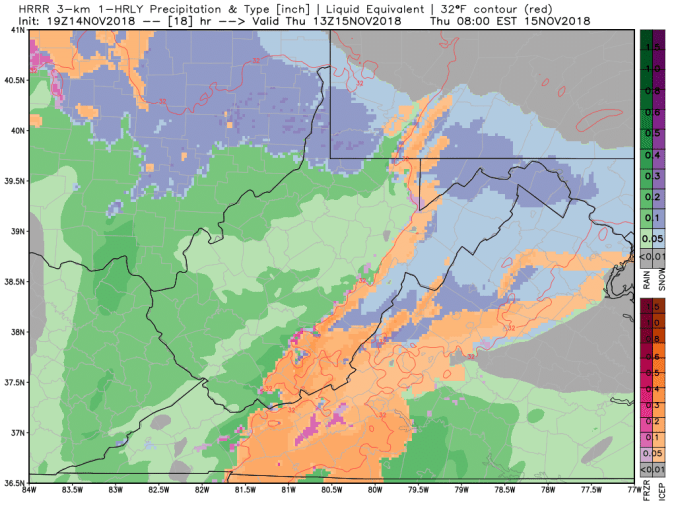
1z HRRR (11/15)
I like the HRRR in this setup. Climatologically it looks like a setup I’ve seen many times. The 3km Nam that I typically favor, looks odd. Very odd.
1Z HRRR
