Nov 10(Sat)               min.       max.      avg

Bitt 2nw valley        18.6       33.6      26.1

Garrett College        18.5        33.8      26.1

Can-Heights             13.6        30.3      22.0

CRN-Canaan            15.5        31.2      23.4

Cabin Mt                   11.3       27.9      19.6

Cabin Mt north       13.6       28.9      21.2

Spruce Knob           11.3       26.2      18.7

Snowshoe                12.9      26.6      19.8

Can-Valley Floor    10.6      32.5      21.5

7Springs                   17.9     31.3      24.6

Some overnight snow…coating the upslope areas. Snowshowers on and off through midday, windy, blustery…skies breaking this afternoon.

Temp profile this afternoon…….

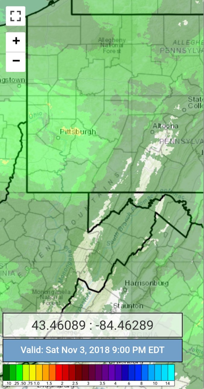
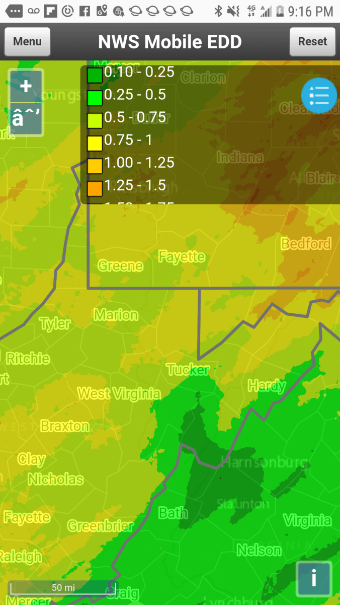
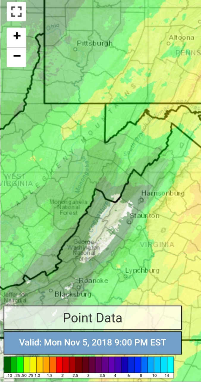
Radar with estimates 9pm-9pm. Picked up .1 liquid at Bittinger 2nw Valley. It’s the season of low cloud tops. Some Mt. snow undetected by radar. Radar in Pitt, Charleston, Sterling, overshoot the precip tops in the area. Canaan marks the center of the furthest distance away from all 3. With nearby areas poor also. That said, radar estimates will be poor.
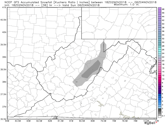
Screenshot_20181110-215934

Snowfall 2018-11-10-20-58-25

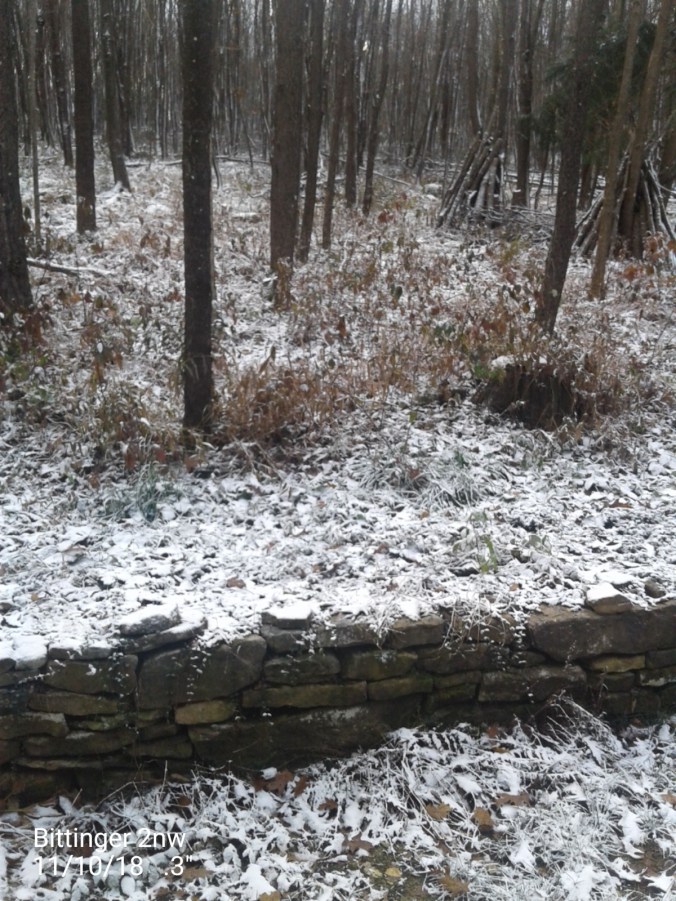
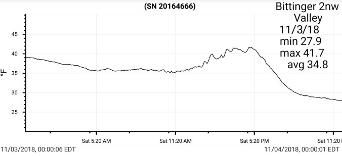
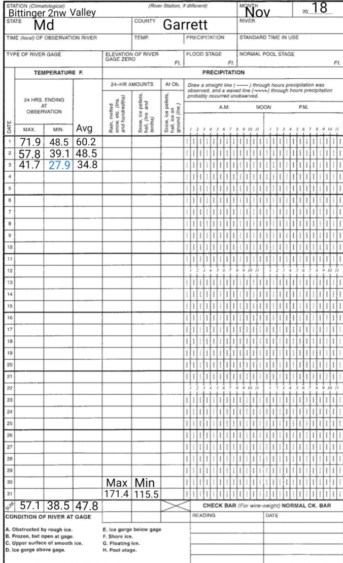
.3″ at Bittinger 2nw Valley 1.3″ season total

.6″ at Canaan Heights 3.6″ season total

Satellite

Flow

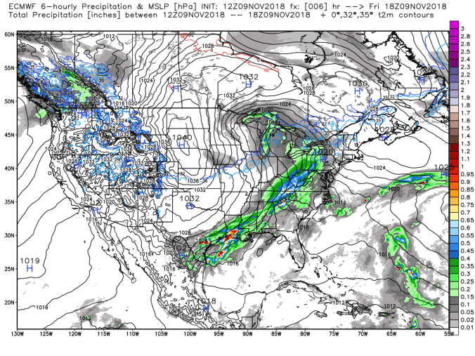
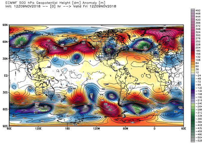
Surface features and 500mb height anomalies and flow…..


Keysers Ridge early a.m

Snowshoe, snow making beginning early a.m

Video this afternoon at Cranberry Glades by Hot For The Hills Wv.. also check out their Facebook page under the same name

The winds today. Along the exposed areas of Cabin Mt above 4000′, wind gust topped 60mph, sustained 30-40mph with temps in the teens put windchills below 0 a good portion of the day.


Looking ahead…

Skies clearing, winds dying. Dew Points near 0 in spots.. Some of the coldest high valleys have a shot at 0 or just below tonight. Tomorrow night, the high ground may hold 30-35. Places like Snowshoe may be able to make +32° snow with the dry air in place. Some precip moves in Monday. Perhaps some freezing rain at the onset. Then a cold rain, backend snow(1-3″) with another cold shot. The temp moderation late week again is with dry air. Dew Points remain low. Ski resorts man made snow is basically bulletproof with low dew points even with daytime temps 40-50. Which 50 doesn’t look to occur through the next 7 days. Last November was a great ecample of that. We had a 2-3″ fluffy snow event on the 19th. Some of which remained on December 1st despite no more snow and temps 40-50 often in the period.

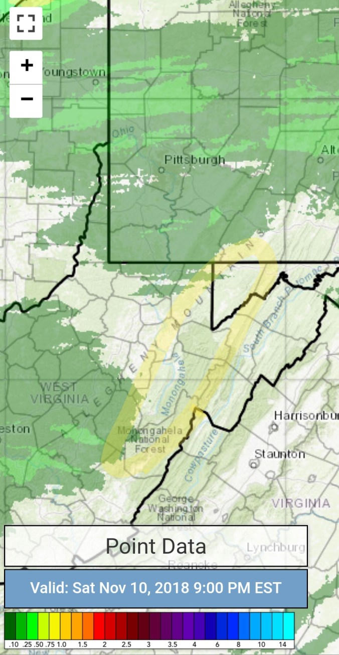
Maybe a upslope snow event next weekend.

Nov 9(Fri)                 min.      max.     avg

Bitt 2nw valley      33.4      43.0.     38.2

Garrett College        33.5     44.2      38.8

Can-Heights            30.3      44.2      37.2

CRN-Canaan           30.9       42.1     36.5

Cabin Mt                 27.7       42.6     35.1

Cabin Mt north     28.9       45.1      37.0

Spruce Knob         26.4       40.8      33.6

Snowshoe              26.4       39.2      32.8

Can-Valley Floor   32.2       44.6     38.4

7Springs                 30.7       41.0     35.8

Cloudy, rain…

Temp profile this afternoon


Radar with estimates 9pm-9pm . Picked up .9 at Bittinger 2nw Valley

Screenshot_20181109-211613

Satellite

Flow

Surface features and 500mb height anomalies and flowecmwf_slp_precip_conus2_2-50ecm_z500_anom_globe_1-49.png

Nov 8                         min.      max.      avg

Bitt 2nw valley      28.6         45.2      36.9

Garrett College      30.0         46.8       38.4

Can-Heights            26.9        45.0       36.0

CRN-Canaan           28.0        47.4       37.7

Cabin Mt                 28.2        45.0       36.6

Cabin Mt north     29.8         44.6      37.2

Spruce Knob         29.5          45.9     37.5

Snowshoe              33.8          46.9    40.3

Can-Valley Floor  20.8          49.6    35.2

7Springs                27.7          38.8    33.2

Clear start, some odd foggy areas. Dense spots and blue sky….gave way to sunny skies that eventually became gave way to more overcast later in the day

Temp profile this afternoon

no precip

Satellite

Flow

Surface features and 500mb height anomalies and flow


Pics today


Nov 7(Wed)              min.      max.       avg

Bitt 2nw valley         33.9      51.4      42.6

Garrett College        41.5       51.0      46.2

Can-Heights             34.8       47.4      41.1

CRN-Canaan            38.3       51.5      44.9

Cabin Mt                  33.1       49.6      41.3

Cabin Mt north      34.3        46.2     40.2

Spruce Knob          33.8        46.2     40.0

Snowshoe              35.6         47.1     41.2

Can-Valley Floor  28.8         52.3     40.5

7Springs                36.0         45.1     40.5

Clear, breezy start. Mins not far from 40, but patchy frost existed in a few spots.  Some clouds dimmed the sun through the afternoon

Temp profile this afternoon


no precip

Satellite

Flow

Surface features and 500mb height anomalies and flow


Nov 6(Tues)               min.      max.     avg

Bitt 2nw valley        45.8         58.6      52.2

Garrett College       46.3         59.1      52.7

Can-Heights            42.9         54.8      48.8

CRN-Canaan           44.3         56.9      50.6

Cabin Mt                 41.0         53.2      47.1

Cabin Mt north     42.6         56.7      49.6

Spruce Knob         39.0        50.5       44.7

Snowshoe              40.1        51.3      45.7

Can-Valley Floor  31.6        58.1      44.8

7Springs                44.1        56.4      50.2

Starting off with rain, wind, some areas with some storms….slowly gave way to breaking skies midday on.

Temp profile this afternoon


Radar with estimates 9pm-9pm Picked up .25 at Bittinger 2nw Valley

Screenshot_20181106-212014

Satellite

Flow

Surface features and 500mb height anomalies and flow


On the models…..10466-b143643a-bf8d-47c4-83ea-4a410653a739

Mini taste coming in Saturday with Friday/Friday night’s showers changing to snow showers. Continuing Saturday. Looks like coatings to a inch.  That melts off Sunday and the focus goes to early to mid next week.(Looking like Tuesdau-Wednesday) Snowshowers, upslope snows, windy, cold and downright cold. We may have days mid next week with highs 18-23° for most and 12-18° for areas above 4000′ mins in the single digits, windchills 0 to 10 below during the coldest period with windchills in excess of -20 above 4000′. Late week, as high pressure moves in, with any snow cover, the coldest high valleys may see air temps dropping below 0. That’s on the table. That’s potentially what we are looking at. Really a taste of real winter weather. This upcoming period should be like hooking jumper cables up to dead battery for ski resorts that are looking to get a early start. Snowshoe, 7Springs are a lock for this, will anyone else follow suit?  This is not to say we are locked into winter, but this should allow for a good base for areas wishing for the jump start.

12z ECMWF precip type next 240hrs

12z ECMWF 2m Temperatures

12z ECMWF windchills…keep in mind, this is a 9km model.. High ground can and does often beat these numbers

Too far out to throw in snow amounts. But, this far out plan to have snow covered roads, blowing snow and plowable snow. Those details will come as we get closer.

Nov 5(Mon)             min.       max.      avg

Bitt 2nw valley       40.8        52.3       46.5

Garrett College       41.0       55.9       48.5

Can-Heights            42.3       57.5       49.9

CRN-Canaan           43.6       58.8       51.2

Cabin Mt.                37.6       55.8       46.7

Cabin Mt north     38.3       56.3       47.3

Spruce Knob         37.0       52.7       44.8

Snowshoe              37.9       52.9      45.4

Can-Valley Floor  31.8       61.2      46.5

7Springs                38.6       52.0      45.3

Rain overnight, early a.m. SE flow at surface, fog along eastern ridges. Mainly cloudy, brief peaks of sun.  More sun west. Canaan west sun, western Garrett more sun vs east

Temp profile this afternoon, also 3km Nam that looks more like reality than the RTMA.  Also included fog areas off the 3km nam that did well. Refer to pics to see some of the fog spots.

Radar with estimates 9pm-9pm. Picked up .45 at Bittinger 2nw Valley

Screenshot_20181105-212519

Satellite

Flow

Surface features and 500mb height anomalies and flow

The Fog… in Garrett the difference from Savage Mt to Keysers Ridge is generally great in this setup..today no different

The fog across Cabin Mt was impressive and cool

The northern end of Cabin was more impressive . I took the first 2 pics around 1:30pm. Dave Lesher took the 3rd one a little bit later. You can see advancement. Also on cam how long it took to come across southern Cabin.

Pics today

Canaan Mt tranquillity

On the models….

Short term, watching line of strong storms set to move through around daybreak. Biggest risk, downpours, strong winds embedded within the storms.

Further out, colder air works its say in, some cold rain late week, mixing with snow Saturday….then we watch to see how much cold pushes and where the storm track sets up. Going into a winter like pattern for Mid November

18z GFS 2m temperatures

18z GFS precip type

Nov 4(Sun)              min.     max.      avg

Bitt 2nw valley       24.8      48.2       36.5

Garrett College       25.9      50.1      38.0

Can-Heights            27.1      46.7      36.9

CRN-Canaan          25.2       49.1      37.1

Cabin Mt.               31.8       42.9      37.3

Cabin Mt north     30.7      42.6      36.7

Spruce Knob         28.0       39.2     33.6

Snowshoe             32.9        42.6    37.8

Can-Valley Floor 20.1

7Springs               33.2       44.6      38.9

Mostly sunny day, some clouds early and then returning late with easterly winds increasing.

Temp profile this afternoon


Precip free

Satellite

Flow

Surface features and 500mb height anomalies and flow


Pics today


On the models..

Rain pushing in overnight….severe weather possible Monday night/ early Tuesday. Looking further out, a significant cold push for mid month. This should get Snowshoe, 7Springs cranking. There is a likely a late month warm up. But the duration of cold should allow s good base to be put down to pull through that. Also keep in mind, dewpoints are as critical as ambient temps. Refer back to last November on this blog. We had a 2-3″ snow that lasted 2 weeks in shady north facing slopes despite 45-50° temps .

12z ECMWF 2m Temperatures

18z GFS 2m temperatures

Nov 3 (Sat)              min.     Max.     avg

Bitt 2nw valley     27.9       41.7      34.8

Garrett College    30.1        40.5     35.3

Can-Heights         29.3        36.2     32.8

CRN-Canaan        27.2        37.5      32.4

Cabin Mt              27.9        34.3      31.1

Cabin Mt north   28.9       35.1      32.0

Spruce Knob        26.4       33.6     30.0

Snowshoe              27.1      32.9     30.0

Can-Valley Floor  23.9      39.4     31.6

7Springs                32.2      38.0     35.1

Cloudy, rain and snowshowers below 3000′ with mainly snowshowers above 3000′ and stickage mainly above 3400-3500′. Skies broke during the afternoon.

Temp profile this afternoon


2018-11-04-10-35-272018-11-06-09-13-36
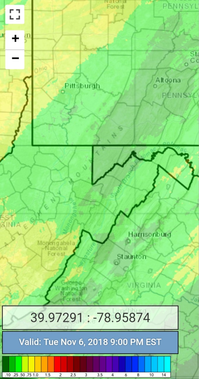
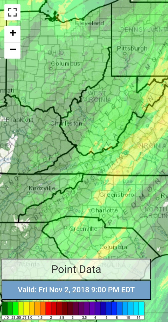
Radar with estimates 9pm-9pm. Picked up .25 at Bittinger 2nw Valley (Radar estimates are very poor the past 24hrs)

Screenshot_20181103-212137

Satellite

Flow

Surface features and 500mb height anomalies and flow


Pics today

2 by Vernon Patterson atop Bald Knob at Canaan Valley this afternoon


2 by Jonathan Gladysz at Canaan Mt today


Pics by Judy K Mullens at Spruce Knob this afternoon


Webcam shot at Snowshoe


Webcam shots at Canaan


Videos from Snowshoe

Few from Garrett County Md

Nov 2.                         min.     max.     avg

Bitt 2nw valley         39.1      57.8      48.5

Garrett College        39.2      62.8       57.0

Can-Heights             37.4      58.6       48.0

CRN-Canaan            36.6      60.0       48.3

Cabin Mt.                 34.7      56.8       45.7

Cabin Mt north      35.4       57.4      46.4

Spruce Knob          33.8       53.1     43.4

Snowshoe               32.9      52.7      42.8

Can-Valley Floor   38.5      61.2      49.8

7Springs                 36.7      60.7      48.7

Mainly cloudy, little rain overnight, some afternoon drizzle at times, to a period of evening /nightfall rain..

Temp profile this afternoon


Radar with estimates 9pm-9pm… picked up .15 at Bittinger 2nw Valley through 6pm

Screenshot_20181102-211112

Satellite

Flow

Surface features and 500mb height anomalies and flow


On the models….

Showers, mixing and changing to some scattered light snowshowers across the high ground late tonight , early a.m. Little if any accumulation. A colder, blustery day tomorrow.

18z 3km Nam 2m temperatures

18z 3km Nam WindChills

18z 3km Nam Simulated Radar

18z GFS 2m temperatures next 240 hours

18z precip type next 240hrs

Snowfall off 18z GFSgfs_snow_Ku_acc_wv_7.png

Nov 1.                         min.      max.     Avg

Bitt 2nw valley        48.5       71.9       60.2

Garrett College        57.6       72.7      65.1

Can-Heights             53.3       67.1      60.3

CRN-Canaan            52.2       67.8      60.0

Cabin Mt                 50.9        64.8      57.8

Cabin Mt north      51.4        67.1      59.2

Spruce Knob          47.8        61.5      54.6

Snowshoe               50.7        57.6      54.1

Can-Valley Floor   52.9        69.4      61.1

7Springs                 54.6        69.3     62.0

Mix of clouds and sun, high clouds. Pleasant day. Some light showers after dark..

Temp profile this afternoon


Radar with estimates 9pm-9pm

Screenshot_20181101-210614

Satellite

Flow

Surface features and 500mb height anomalies and flow


Pics today…..