Dec 9(Sun) min. max. avg
Bitt 2nw valley 10.1 25.3 17.7
Garrett College 16.2 26.2 21.2
Can-Heights 17.8 32.2 25.0
Cabin Mt. 15.5 32.8 24.2
Cabin Mt north 16.2 28.2 22.2
Spruce Knob 12.9 27.3 20.1
Snowshoe 15.4 29.5 22.5
Can-Valley Floor 13.3 32.5 22.9
7Springs 13.3 32.0 22.6
Cloudy skies, easterly flow.. Snow into the southern Alleghenies and heavy snow in southern Wv, across Va, and the Carolinas and Tn mts. 1-2′ in spots.
Temp profile this afternoon


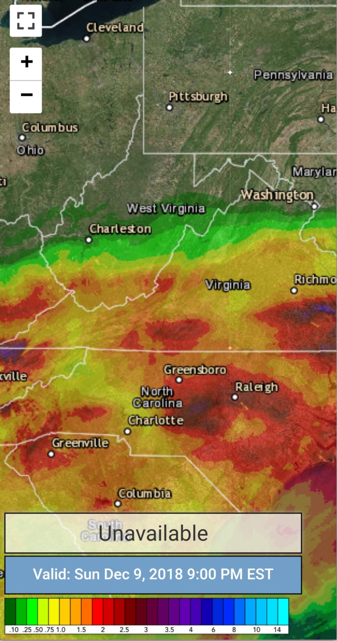
Radar(heavy snow south), precip amounts. Posting the liquid amounts, will post a snowfall tally map tomorrow. As a large portion was snow.
Satellite
Flow
Surface features and 500mb height anomalies and flow


Some amounts from the storm through 5pm
5 PM TOP SNOW AMOUNTS:
NORTH CAROLINA / VIRGINIA (>=17″):
Whitetop, VA: 24.0″
Valle Crucis, NC: 21.0″
Piney Creek, NC: 20.5″
Sugar Mountain, NC: 20.0″
FLoyd, VA: 20.0″
Swansonville, VA: 20.0″
Mouth of Wilson, VA: 19.5″
Wytheville, VA: 19.3″
Sparta, NC: 18.5″
Saluda, NC: 18.5″
Cedar Mountain, NC: 18.0″
Lenoir, NC: 18.0″
Meat Camp, NC: 18.0″
Little Switzerland, NC: 18.0″
Linville, NC: 18.0″
Rocky Bottom, NC: 18.0″
Fleetwood, NC: 18.0″
Ratherwood, NC: 18.0″
Snow Creek, NC: 18.0″
Baldwin, NC: 18.0″
Galax, VA: 18.0″
Rural Retreat, VA: 18.0″
Fries, VA: 18.0″
Lone Hickory, NC: 17.5″
Aho, NC: 17.5″
Sheffield, NC: 17.5″
Blairs, VA: 17.0″
Elk Creek, VA: 17.0″
Hays, NC: 17.0″
Swannanoa, NC: 17.0″
Clifton, NC: 17.0″
Ivanhoe, VA: 17.0″
WEST VIRGINIA (TOP 5):
Matoaka, WV: 15.8″
Glenray, WV: 15.0″
ELlison, WV: 15.0″
Crab Orchard, WV: 14.5″
Cool Ridge, WV: 14.0″
TENNESSEE (TOP 5):
Mountain City, TN: 12.0″
Kingsport, TN: 12.0″
Gray, TN: 11.0″
Mount Carmel, TN: 11.0″
Gray, TN: 11.0″
SOUTH CAROLINA (TOP 5):
Inman, SC: 11.9″
Green Creek, SC: 8.5″
Landrum, SC: 8.0″
Gaffney, SC: 7.0″
Mountain Rest, sC: 7.0″
OTHER STATES:
Sky Valley, GA: 8.0″
Leonardtown, MD: 4.0″
Beech Mt N.C
