Cloudy, showers, some low fog to start. Valleys cooler than high areas. By late morning all areas 48-55.. Some breaks of sun, even a rainbow. Clouds, fog, rain return afternoon, dropping temps, rain to snow by 7pm. Ground white by 8pm.
Temp profile this afternoon
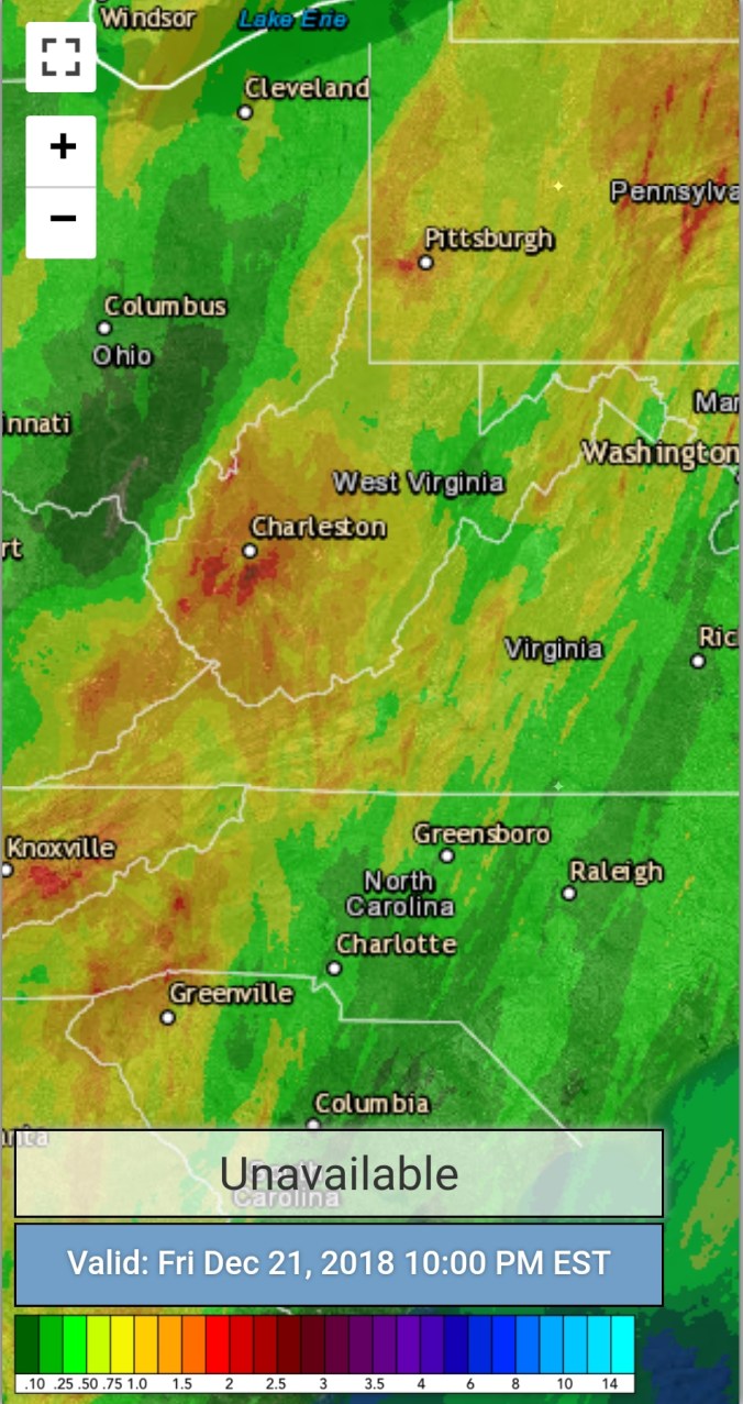
Radar with 24 estimates 10pm. At 7am Bittinger 2nw in at .33
Satellite
Flow
Surface features and 500mb height anomalies and flow
Pics today
Looking ahead
Snow tonight, general 2-4 eastern Alleghenies, 3-6″ central, 4-8 best upslope areas…. A event Sunday night looks to drop a few more inches… Christmas Day looks to have snow on the ground
Mainly clear start, fairly wide temp ranges overnight from valley to high ground. Clouds building in, rain in the afternoon. Temps into the 30-35 range in eastern Alleghenies. Weather Service with their grid forecast will never get this right apparently, despite it being modeled very well.
Temp profile this afternoon
Radar with estimates 9pm-9pm
Satellite
Flow
Surface features and 500mb height anomalies and flow
As much as I hate this, the NWS forecast grid, the repeatedly using of this grid to forecast temps in this setup is just plain awful. This is probably the 1000th time I’ve mentioned it over the years. Why on earth is this grid used, when there are high real models that do much better and have proven so, time and time again. No forecast mentioned 30s this afternoon, let alone near freezing. 3km Nam showed it clearly and the models track record in the setup is phenomenal. Let’s look… Temps, then NWS forecast beginning tonight.. You’ll see not only well off this evening, they flood the warmth back in way to fast tonight. Big consistent warm bias…
12z 3km Nam 2m temperatures from the morning
Now a look back to last night..
That was min forecast. That is airport grid based..That forecast done poor for most locations. High ground held near 36-40 most of the night. A lot of towns sit a little lower, a lot of people live in valleys, hollows, creek bottoms. Temps there ran mostly 20-27°. (Coldest pockets teens) Why would you not give a forecast for those 2 distinct areas vs a general 32° everyone near or above freezing…not even remotely near reality. The temps were off that not very long after that forecast was issued.
Cloudy start, a few stray tiny flakes briefly early…then skies breaking for sun and blue skies..
Temp profile this afternoon
Radar void of precip
Satellite
Flow
Surface features and 500mb height anomalies and flow
Wisp 7:30pm
Canaan Resort report by Justin Harris
On the models
Rain pushing in Friday, changes to snow overnight. Looking like a 2-5″ evebt into Saturday and that may need tweaked up or down a little as we get closer. Maybe a few festive flakes Christmas eve, borderline temps… Christmas Day looking dry, with precip coming in overnight or the following day. Long ways off, and lots of tweaks between now and then.
Cloudy, drizzly, fog, some high eastern spots on the northern extent of 4000′ Allegheny Front likely had a touch of ice this a.m. That was limited and not as widespread as modeled and the area under an advisory.
Temp profile this afternoon
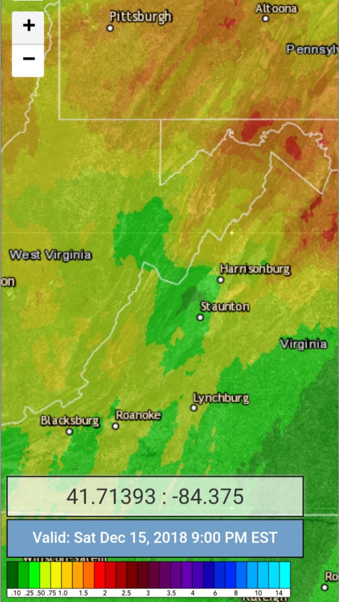
Radar with estimates 9pm-9pm, Bittinger 2nw/AKA Accident 3.9E with .32 more since last evening messurent for a storm total of 2.3″
Satellite
Flow
Surface features and 500mb height anomalies and flow
Rain, some fog, easterly winds, moist, damp, just plain miserable. The rainfall put some creeks, smaller waterways out of their banks. Locally, the Cassleman was out of its banks and over a few roadways.
Temp profile this afternoon
Radar with estimates 9pm-9pm. Bittinger 2nw, now listed as Accident 3.9E Cocorahs site ran by Bill Buckle with 1.98 rainfall for event total through 6pm, additional rain falling
Satellite
Flow
Surface features and 500mb height anomalies and flow
On the models….
Watching the possibility for some wintry precip tomorrow. Maybe a burst of wet snow, and a little ice. Some disagreement within the modeling. Here are a few short range models that have it.
Cloudy, lighy, damp east flow. Light rain beginning in the afternoon. Temps with the east flow were much colder in Garrett than the NWS forecast. A repeated occurrence for many many years. 3km Nam continues to model this excellent.
Temp profile this afternoon
Radar with estimates 9pm-9pm
Satellite
Flow
Surface features and 500mb height anomalies and flow
Mainly clear start with high cloud deck building and lowering into the afternoon before briefly breaking predusk.. Then clouds rolling back in after dark with extremely light, scattered ice pellets to a touch of drizzle. With temps >32 in areas.
Temp profile this afternoon
Radar….very very, I stress light precip after dark
Satellite
Flow
Surface features and 500mb height anomalies and flow
Few pics on the day. Actually a guy out ice fishing in Cherry Creek Cove on Deep Creek Lake