Clear,,very cold start(especially high valleys) and abundant sunshine today in my area. Cloud cover increased as you traversed south, and also to the northwest….
Temp profile this afternoon
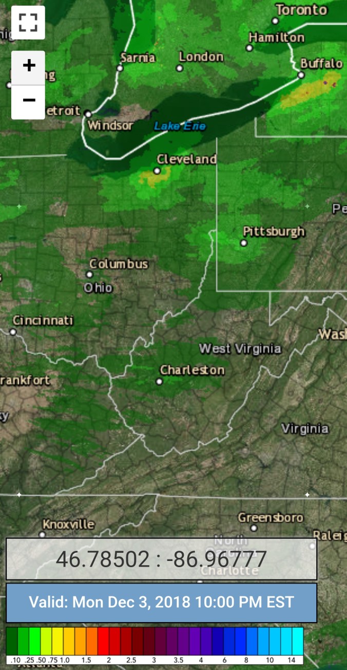
Radar(going back to last night)
Snowfall amounts- Snowshoe, both the co-op and the resort reporting 4″ total event. Those numbers increased south, and east. Mt. Mitchell reporting 34″, Burkes Garden 15″, Wintergreen Resort 20″
Satellite
Flow
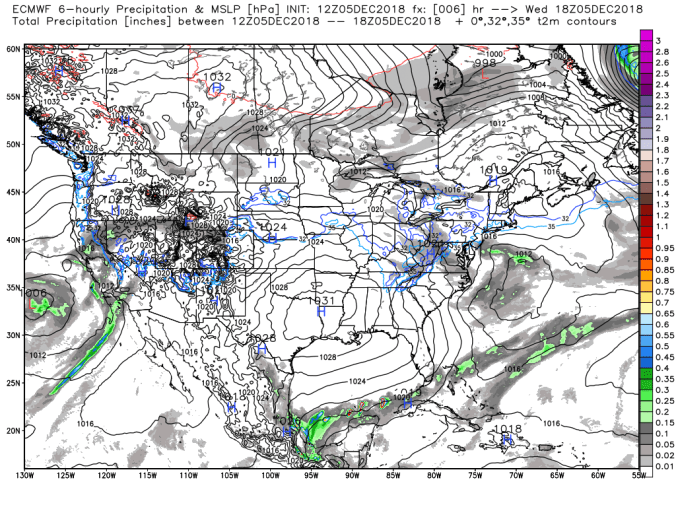
Surface features and 500mb height anomalies and flow
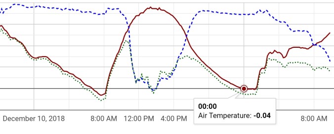
Valley mins, Canaans cold pockets below 0, down to -3.1 on the valley floor at Timberline Rd, while at that time it was 21.9 on Bald Knob. Also of interest, the temp at The frost pocket site at Canaan went from -3.1 to +37.9, a rise of 41° by 1:40pm, then back to 0.0 at midnight
The Glades in Garrett County at -1.8°.
Pics on the day
The Glades
Pics by Justin Harris around Canaan Valley and the ski area today
Canaan Valley Resort report by Justin Harris. Opening day this weekend. Get out there! Saturday may be milder, but there will be plenty of snow.
Ahead…
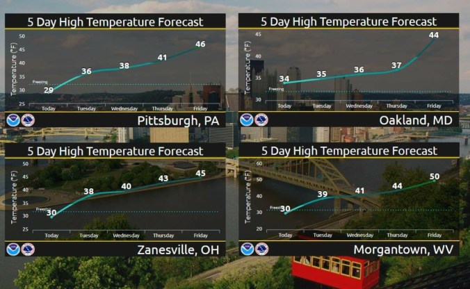
As we go into the mild pattern, some light snow Thursday and some areas may see a light mix Friday. The Pitt forecast of 44 Friday in Garrett County looks well high, and one that’s adjusted down as we go closer. SE flow, usually equals greater than a 2° to Pitt and 6° to Morgantown.
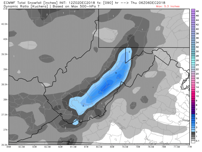
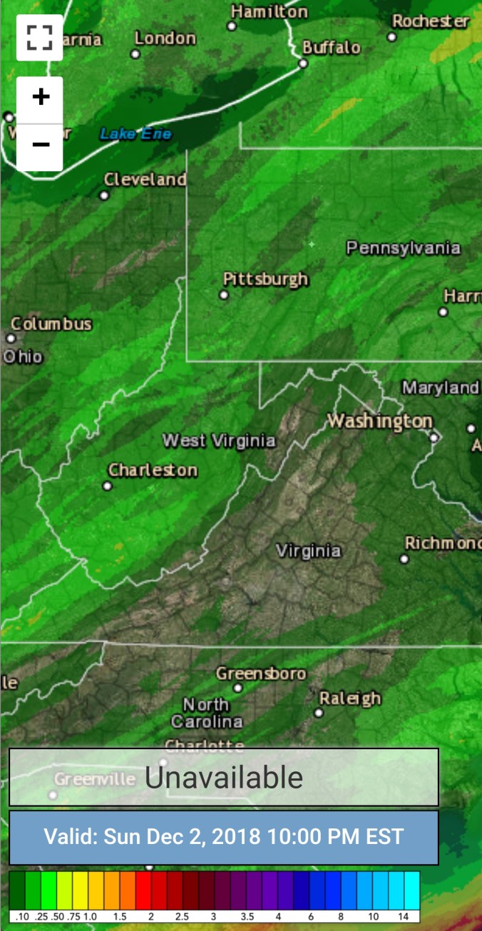
Cloudy skies, easterly flow.. Snow into the southern Alleghenies and heavy snow in southern Wv, across Va, and the Carolinas and Tn mts. 1-2′ in spots.
Temp profile this afternoon
Radar(heavy snow south), precip amounts. Posting the liquid amounts, will post a snowfall tally map tomorrow. As a large portion was snow.
Satellite
Flow
Surface features and 500mb height anomalies and flow
After a mostly clear night for the most part, that brought with it the coldest mins of the season. Just after midnight, temps then rose as light breezes kicked in area wide around 2-3am as well as a thin high cloud deck. A cold partly cloudy day, high thin cloud deck at times. The cloud deck was more dominant as you went south in the Alleghenies.
Temp profile this afternoon
Radar-void of precip
Satellite
Flow
Surface features and 500mb height anomalies and flow
Pics today
Coooold Valleys. The valley site along Timberline Rd dropped to -1.6 last night at midnight(that will give a below 0 reading for 2 days now) before a wind increase occured mixing out the coldest air with the air aloft. There is no anemometer at the Timerline site, but nearby to the north, you can see the temp and winds overnight at Garrett College.
On the models….
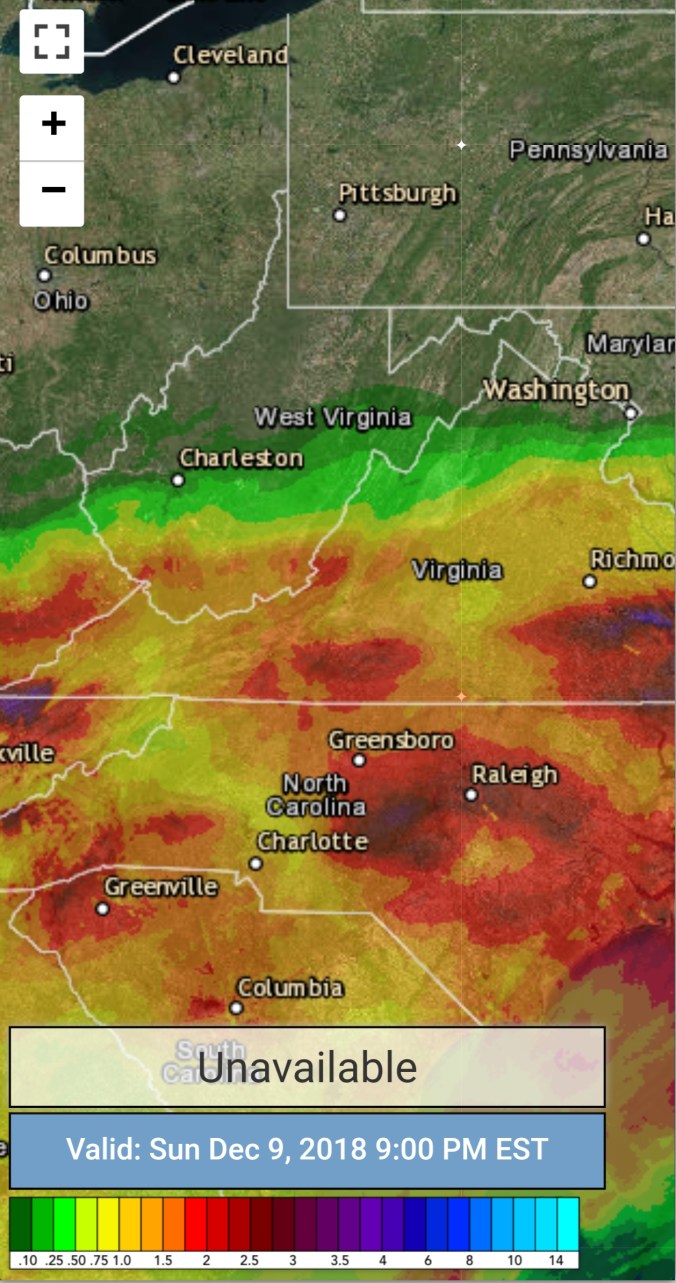
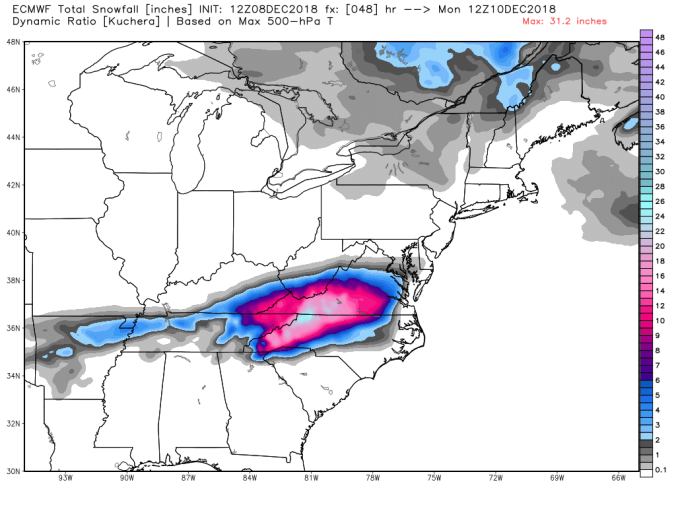
Short term, the southern App snow storm tonight through tomorrow. 15-24″ with pockets over that possible down there. Flakes may make it as far north as Canaan, light accumulation as far north as Pocahontas County. After this passes, the overall winter pattern look pretty “blah” for winter lovers leading up to the holiday season.
The pattern becomes dominated by modified Pacific Air. Lots of LP over the NE Pacific flooding in the Pacific flow and cutting off the tap into the artic air. It’s not terribly warm, its modified into the 25-45 range with most precip events drawing up mild up for wet vs white, with any white only occuring in the mountains as the system passes and winds shift N.W.
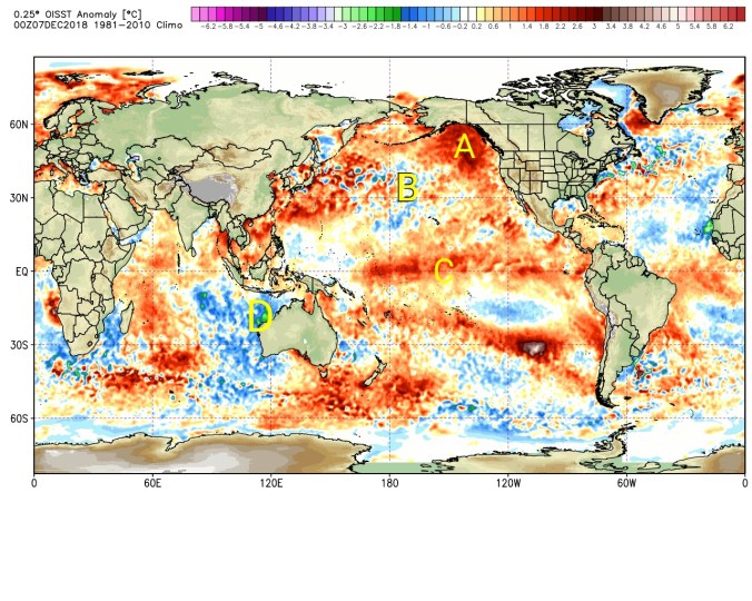
Lots of warmth in the NE Pacific. That feature becomes our best friend as we go into “real winter” and wave lengths shorten. Like back in 13-14, until then, it can leads to floods of Pacific Air across the nation and I’m surprised it took until mid December to occur. That SST setup is really a setup for a good winter. Primed for a – EPO, favorable MJO phases and a active southern jet. That cold pool 30N near the dateline, with warmth to the NE of that is a classic east cold signal. (A and B) Modiki Nino, active southern jet (C) and the cold pool in the eastern Indian Ocean, favors sinking air and convection being most active in phases 8, 1,2,3 which in winter are great for eastern cold. As the wave lengths tighten. At present, +EPO, a MJO going into phase 3,4 another less than ideal sign for winter lovers over the coming period leading up to the holidays.
We can still see snow in this pattern in the Alleghenies. It’s a little more difficult, but a favorable track can lead to backside snows. Not all is lost, its just not one if you love winter you get overly excited about short term. Things look to reverse course as we go into the holiday period Christmas to New Year’s, pressures build across western Canada, EPO goes -, MJO into more favorable phases and we are back in business. The things that cause pain now, can lead to great things in the long term.
Current SST anomalies
Previous winter SST anomalies with temp correlations
You’ll have trouble finding below anomalies at the dateline with warm NE Pacific, cold eastern Indian Ocean in a modiki Nino year giving the eastern U.S a mild winter.
Cloudy start, stray flurries early, turning into a partly cloudy day after the period of snow last night. Remaining cold.
Temp profile this afternoon
Radar
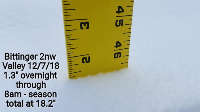
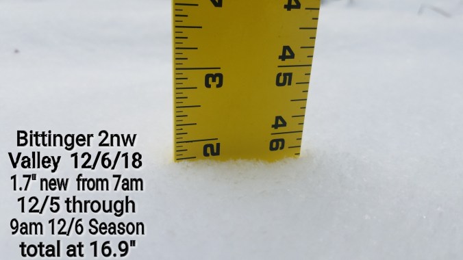
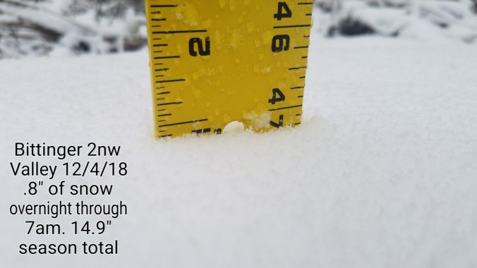
Snowfall- 1.3″ at Bittinger 2nw Valley overnight through 7am. Season total at 18.2″
.7″ overnight at Canaan Heights. Season total 25.8″
Satellite
Flow
Surface features and 500mb height anomalies and flow
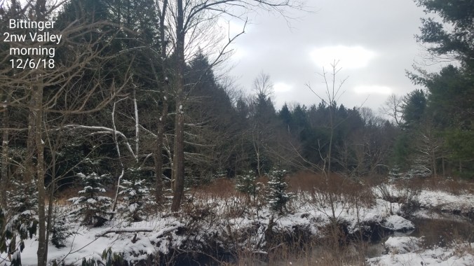
Pics today
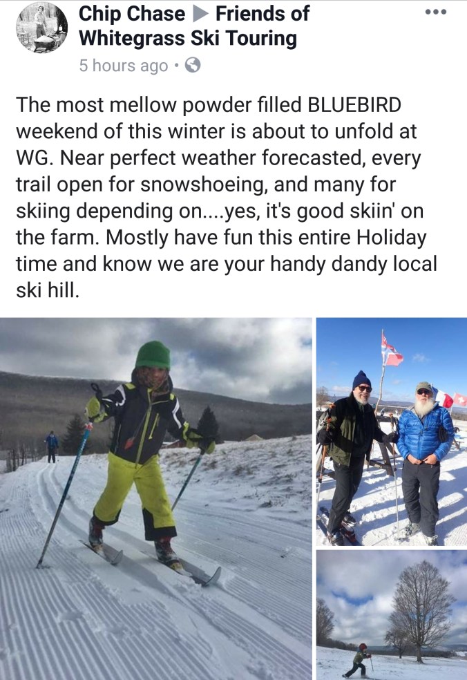
Pics by Chip Chase at Whitegrass….get out there and ski it this weekend!
Video by Renee Morris on Cabin Mt
On the models….
With the short term storm passing by south and tranquil weather following, nothing in the short term looks terribly exciting, EXCEPT some valleys below 0 tonight. Overall the pattern looks to become more zonal, flooded with Pacific Air which will cut off any extreme cold next week, into mid month. That said, any warm surges look minimal and only based on storm track if any occurs. Temps look modified, and 20s, to low 40s range. Precip events likely of the rain to snow variety. Not any true cold storms, but any event with a favorable track could be cold enough for wet Mt. snow.
Overall the pattern begins to return more favorable as we go into the holiday stretch.
Mainly cloudy, periods of light snow, pockets of moderate snow. Brief glimpses of sun at times.
Temp profile this afternoon
Radar
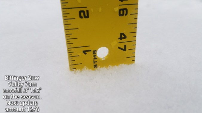
Snowfall- Picked up .3 overnight at Bittinger 2nw Valley through 7am. Snow continued on and off today, will include those amounts in tomorrow mornings ob..
Satellite
Flow
Surface features and 500mb height anomalies and flow
Pics today
At Keysers Ridge today as a moderate burst pushed in
Cloudy, turning colder. Period of light drizzle in the morning. Brief snow shower, fine flakes in the afternoon, with better snowshowers after dark(See video below)
Temp profile this afternoon.
Radar with estimates 10pm-10pm. ☆ Light snow covering exists at 10pm. Radar estimates are not perfect.
Satellite
Flow
Surface features and 500mb height anomalies and flow..
Pics today
On the models….
Snow showers tonight into Tuesday a.m. .5 to 1.5″ across the northern Alleghenies(Garrett, Preston, Somerset, Fayette) 1-3″ across Wv high ground. Snow showers in a slightly more heftier fashion pushes in Tuesday night through Wednesday, Thursday. The currently looks like 2-4″ across northern Alleghenies, and 3-5″ totals across upslope areas of the Wv high ground. Few scattered snowshowers Thursday night with a little more light accumulation Friday.
The weekend storm? Model trends have been a little north today. Southern Alleghenies stand the greatest chance to be in game, and models are still trying to figure the piece of energy as it comes in off the Pacific. So, region wide still has the shot at a major storm. Simply top early to say.
12z ECMWF 2m Temperatures(through Friday)
12z ECMWF precip type through Friday
18z GFS precip type through Friday
Snowfall amounts through Friday off the 12z ECMWF and 18z GFS
Quick look at the GFS snowfall ensembles at 12z vs 18z. The hefty ones obviously see the weekend storm takig a north trend. The 18z had more of those vs the 12z
Started out with low lying fog, calm, cloudy, that gave way to clearing, breezy conditions and rising temps. Not to go unmentioned. Some areas that saw rain last night had a few rumbles of thunder.
Temp profile this afternoon
Radar. I had .05 overnight at Bittinger 2nw Valley…
Satellite
Flow
Surface features and 500mb height anomalies and flow
Pics today
On the models…..
Colder air begins to encroach after midnight(some valleys are near freezing briefly under clear, calm conditions. As the front nears, winds again increase with a temp spike, then fall. Showers go to snowshowers tomorrow. A few round of snow showers from Monday through Wednesday. Light amounts. Looking like 1-3″ northern Alleghenies, 2-4″ through the high Wv ground through Wednesday. It should come in small increments, without advisories.
Next weekend- NO ONE KNOWS WHAT WILL HAPPEN. Storm threat exist, but has a equal chance at being a miss..


 After this passes, the overall winter pattern look pretty “blah” for winter lovers leading up to the holiday season.
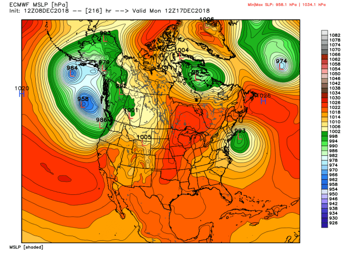
 At present, +EPO, a MJO going into phase 3,4 another less than ideal sign for winter lovers over the coming period leading up to the holidays.


 Satellite