Jan31(Thurs)           min        max       avg

Bitt 2nw Valley

Garrett College

Can-Heights

CRN-Canaan

Cabin Mt

Cabin Mt north

Spruce Knob

Snowshoe

Can-Valley Floor

Can-Valley Floor N

7Springs

Clear, very cold, winds overnight lightened but didn’t die before daybreak.

Temp profile this afternoon

Radar -void

Satellite

Flow

Surface features and 500mb height anomalies and flow

Jan 30(Wed)            min.       max.     avg

Bitt 2nw Valley

Garrett College

Can-Heights

CRN-Canaan

Cabin Mt

Cabin Mt north

Spruce Knob

Snowshoe

Can-Valley Floor

Can-Valley Floor N

7Springs

Light snow at daybreak and heavy near 8:30am with the squall line. Beyond that some fine snow with the falling temps and bitter cold

Temp profile this afternoon

Radar

Snowfall- picked up 1.3″ with the morning snow, with it mostly from the 8:30 squall line with the artic front. New depth on top the hard pack 4.0″, hard pack depth 5″-6″.   Avg SD is 9″. Much higher than other locations. Partly due to almost no melt in the very warm day last week, and no settling in the fluff of blow off like elsewhere over the past day

Satellite

Flow

Surface features and 500mb height anomalies and flow

Pics today

Squall this morning

Jan 29(Tues)             min.     max.    avg

Bitt 2nw Valley

Garrett College

Can-Heights

CRN-Canaan

Cabin Mt

Cabin Mt north

Spruce Knob

Snowshoe

Can-Valley Floor

Can-Valley Floor N

7Springs

Light snow predawn hours, with some better snows during the morning and a few nice pockets of snow, after noon, evening, and after dark. Falling Temps. A big temp difference overnight from Mchenry to Bittinger 2nw Valley again. Mchenry went to 36° overnight, Bittinger 2nw Valley held 20s. Snow, even mixed with rain and struggling to stick up until 6am Mchenry.. Not the case just east.

Temp profile this afternoon..

Radar

Snowfall-picked 6am boardsweep I had picked up .3″ at Bittinger 2nw Valley, through the day up until the 6pm sweep I recorded an additional 2.4″ for a evebt tally of 2.7″ with that pushing the season to date to 50.3″. Snow depth in the valley at 6pm, 7-8.5″.. (at 4 p.m I had 1.9″ on the day, a burst from 4pm to 6pm put down a quick 1/2″ of fluff)

Satellite

Flow

Surface features and 500mb height anomalies and flow

Pics today

Jan 28(Mon)             min        max.     avg

Bitt 2nw Valley

Garrett College

Can-Heights

Cabin Mt

Cabin Mt north

Spruce Knob

Snowshoe

Can-Valley Floor

Can-Valley Floor N

7Springs

Mainly clear beginning to end. Cold valley start. I did not have a logger on the Glades, but with reasonable certainty it likely fell under 0 last night. Colder east, milder west setup today, and a look

Temp profile this afternoon

Radar-void

Satellite

Flow

Surface features and 500mb height anomalies and flow

Pics today


The forecast fail. A repeated, documented over and over and they are so stuck in their ways, I suppose it matters not that it fails, but they don’t budge from their airport grid procedure.

First last night, forecast min for Oakland 16°. 16 was only seen at some of the highest locations(like the airport) Mchenry, Oakland, areas where lots live,,well below 16°..  Today, they set up a temp map with very little variance across the county. The 3km Nam, was very good as always. Reality was, Savage Mt held 20s, not mid 30, I held low 30s not mid 30s, Mchenry ran upper 30s,,not mid 30s  But using that grid,,blending it out, they fail to see the difference and that’s why in freezing rain events their forecast adjust as the event unfolds and is nowcast, not a forecast.. It’s ever changing. The airport grid SUCKS and it’s used and fails and has failed for years.

Jan 27(Sun)              min      max.      avg

Bitt 2nw Valley        8.5        33.6      21.0

Garrett College       18.0        32.8     25.4

Can-Heights             14.9       29.2     22.0

CRN-Canaan

Cabin Mt.                   x

Cabin Mt north        13.6      26.8    20.2

Spruce Knob            13.5       26.4    19.9

Snowshoe                16.7        23.7    20.2

Can-Valley Floor     15.4       30.9    23.1

Can-Valley Floor N   6.1       32.0    19.0

7Springs                   12.3      27.7     20.0

Periods of light snow through the morning, windy, minor accumulations. Breaks of sun as well through the afternoon.

Temp profile this afternoon


Radar


Snowfall- from overnight through event end early afternoon with most occuring 6am and after, picked up .3″ at Bittinger 2nw Valley. 47.6″ on the season.

Satellite

Flow

Surface features and 500mb height anomalies and flow


Pics today


Jan 26(Sat)               min       max       avg

Bitt 2nw Valley         8.3       24.5       16.4

Garrett College      13.2       24.2        18.7

Can-Heights           10.2      23.4         16.8

CRN-Canaan

Cabin Mt                   8.0      15.9****11.9

Cabin Mt north       9.5       18.9       14.2

Spruce Knob            6.6       20.3     13.4

Snowshoe                 8.6       18.0      13.3

Can-Valley Floor      8.2       23.9      16.0

Can-Valley Floor N  2.7      24.1     13.4

7Springs                    9.3      19.6     14.5

Mix of clouds and sun early morning, with a general cloudy sky taking over, with the sun still visible at times. Some very light pockets of snow during the afternoon, evening.

Temp profile this afternoon


Radar

Snowfall- Only a trace, no accumulation

Satellite

Flow

Surface features and 500mb height anomalies and flow


Pics today


Light snow this afternoon. Came down briefly better than this a few hours later

Pics by David Carroll as he repaired the station on Spruce Knob today


Jan 25(Fri)               min       max.      avg

Bitt 2nw Valley       10.5      21.4       15.9

Garrett College       14.1      20.8       17.5

Can-Heights            9.3         19.5       14.4

CRN-Canaan

Cabin Mt.                7.7        15.2     11.4

Cabin Mt north.     8.6        16.2     12.4

Spruce Knob          6.6         13.8    10.2

Snowshoe               8.2        14.2      11.2

Can-Valley Floor    14.5      20.7    17.6

Can-Valley Floor N 11.5     20.1    15.8

7Springs                   9.6       18.5     14.1

Early morning snow showers,giving way to breaking skies and lots of sun. But windy and cold

Temp profile this afternoon


Radar

Snowfall-picked up .7″ overnight at Bittinger 2nw Valley through 6am, and another .1 after. 47.3″ on the season. Snow Depth 6 to 6.5″


2.7″ at Canaan Heights and just over 60″ at 60.1″ on the season(through 7am)

http://data.canaanmtnsnow.com

Satellite

Flow

Surface features and 500mb height anomalies and flow


Pics today


Jan 24(Thurs)          min     max.    avg

Bitt 2nw valley      20.8      37.3      29.0

Garrett College     20.8       47.3     34.0

Can-Heights          17.3       48.1      32.7

CRN-Canaan

Cabin Mt               14.9        46.4     30.6

Cabin Mt north    15.6        47.7     31.6

Spruce Knob        x

Snowshoe              14.2        44.1     29.1

Can-Valley Floor   19.4        51.6     35.5

Can-Valley Floor N 19.6      52.2     35.9

7Springs                   18.5      44.3     31.4

Cloudy, rain overnight. Chilly valleys in spots, while windy and warm other locations. Light rain to snow around 9am. Windy, and turning colder. Some pockets of freezing drizzle as well and some high ground rime.

Temp profile this afternoon

Radar

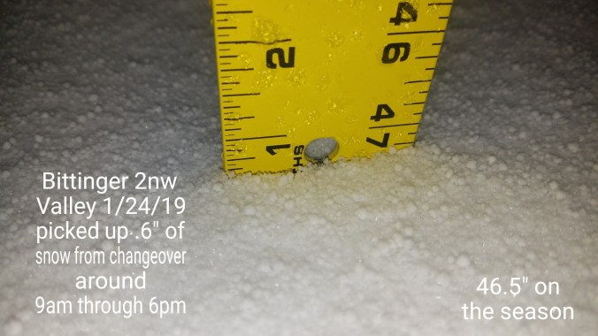
Snowfall. Picked up .6 at Bittinger 2nw Valley through 6pm after morning changeover around 9am2019-01-24-21-31-16

Satellite

Flow

Surface features and 500mb height anomalies and flow


Pics today…notice the big snow cover difference


Those temps yesterday, which held all night

Pics by Michael Maddox at Alpine lake


Jan 23(Wed)             min       max      avg

Bitt 2nw valley       16.9       36.1      26.5

Garrett College       23.6      50.6      37.1

Can-Heights           27.9       48.1      38.0

CRN-Canaan

Cabin Mt                30.6       45.5       38.0

Cabin Mt north     29.7       48.0      38.8

Spruce Knob     x

Snowshoe               26.1       42.3       34.2

Can-Valley Floor     27.7      50.5      39.1

Can-Valley Floor N 33.1      51.3      42.2

7Springs                   23.0      45.5      34.2

Cloudy, early scattered very light precip let to a few areas of light freezing precip. Then lots of clouds, some periods of sun. A HUGE temp variation with some cold valleys, warmer high areas. (Will illustrate in graphic below) some showers late.

Temp profile this afternoon

Radar

Satellite

Flow

Surface features and 500mb height anomalies and flow


Pics today


2 pics at Deep Creek Lake sunrise by Jeremy Brenneman


Wild temps today- colder valleys, protected areas. Snow cover refrigeration effect.  Strong winds afternoon, late day in Mchenry, just east, calm. Very mild through the day in Mchenry, just east cooler and sheltered valleys even cooler yet. The HRRR model did a fantastic job at hinting at this.. see videos below

6pm calm 32.9, snow didn’t even melt off trees any at Bittinger 2nw Valley today….while all afternoon and evening winds going strong at Mchenry.


The Big Storm 3 years ago(Pics at Bittinger 2nw Valley)

Jan 22(Tues)             min.      max.      avg

Bitt 2nw valley         -9.9       21.6      5.8

Garrett College        -6.4        25.5     9.6

Can-Heights             -9.0        29.2     10.1

CRN-Canaan

Cabin Mt.                  2.8        30.9     16.8

Cabin Mt north       -1.6       28.9      13.6

Spruce Knob        x

Snowshoe               8.2        30.0       19.1

Can-Valley Floor     -16.0   33.2      8.6

Can-Valley Floor N -15.3    32.7     8.7

7Springs                    0.1      23.1     11.6

Clear, very cold start, some clouds rolling through in the morning. Some high clouds with sun today.

Temp profile this afternoon

Temp bottomed out at -17.5 on The Glades2019-01-23-21-49-29

Radar free and clear

Snow- Snow Depth at Bittinger 2nw Valley 8″

Satellite

Flow

Surface features and 500mb height anomalies and flow


Pics today