Canaan Cam offline

Mar 21(Thur)           min     max     avg

Bitt 2nw Valley

Garrett College

New Germany SP

Can-Heights

CRN-Canaan

Cabin Mt

Cabin Mt north

Spruce Knob

Snowshoe

Can-Valley Floor

Can-Valley Floor N

7Springs

Cloudy, SE flow transitioning north late. A few flakes, sprinkles. More in the way of flakes along Savage Mt and Backbone… things whitened up awhile at North Fork Mt….and east around Skyline drive. 6-8″ above 3000′

Temp profile this afternoon

Radar

Satellite

Flow

Surface features and 500mb height anomalies and flow

North Fork Mt(did whiten after this video)

Wintergreen Resort

Canaan Cam offline

SPRING ARRIVED AT 5:58PM

Mar 20(Wed)            min      max       avg

Bitt 2nw Valley

Garrett College

New Germany SP

Can-Heights

CRN-Canaan

Cabin Mt

Cabin Mt north

Spruce Knob

Snowshoe

Can-Valley Floor

Can-Valley Floor N

7Springs

High thin clouds through the day. Full moon.

Temp profile this afternoon

Radar void locally

Satellite

Flow

Surface features and 500mb height anomalies and flow

Canaan Cam offline

Mar 19(Tues)           min      max.      avg

Bitt 2nw Valley

Garrett College

New Germany SP

Can-Heights

CRN-Canaan

Cabin Mt

Cabin Mt north

Spruce Knob

Snowshoe

Can-Valley Floor

Can-Valley Floor N

7Springs

Clear cold start, brief period of morning clouds, then a fast return to mostly sunny skies.

Temp profile this afternoon

Radar void of precip

Satellite

Flow

Surface features and 500mb height anomalies and flow

Canaan Cam offline

Mar 18(Mon)             min      max       avg

Bitt 2nw Valley

Garrett College

New Germany SP

Can-Heights

CRN-Canaan

Cabin Mt

Cabin Mt north

Spruce Knob

Snowshoe

Can-Valley Floor

Can-Valley Floor N

7Springs

Cloudy in the morning, with breaks, pockets of snowshowers into the afternoon. Heavier around Cranesville to Deep Creek vs north at Bittinger. Dying off mid to late afternoon.

Temp profile this afternoon

Radar

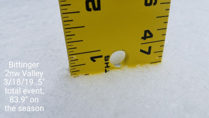
Snow- Picked up a total of .5″ at Bittinger 2nw Valley for the event, 83.9″ on the season…. todays snow melted off in the sunny areas in the afternoon.  Shaded spots only areas of remaining snow and this mornings snow. Towards Deep Creek today, more snow fell vs north. A few heavy pockets. I’d say 1.5″ or greater2019-03-18-21-09-02

Satellite

Flow

Surface features and 500mb height anomalies and flow

Pics today

Canaan Cam offline

Mar 17(Sun)              min       max       avg

Bitt 2nw Valley

Garrett College

New Germany SP

Can-Heights

CRN-Canaan

Cabin Mt

Cabin Mt north

Spruce Knob

Snowshoe

Can-Valley Floor

Can-Valley Floor N

7Springs

Partly cloudy start, cold wind, to a party to mostly sunny day. Remaining chilly.

Temp profile this afternoon

Radar void

Satellite

Flow

Surface features and 500mb height anomalies and flow

Pics today

Canaan Cam offline

Mar 16(Sat)           min       max       avg

Bitt 2nw Valley

Garrett College

New Germany SP

Can-Heights

CRN-Canaan

Cabin Mt

Cabin Mt north

Spruce Knob

Snowshoe

Can-Valley Floor

Can-Valley Floor N

7Springs

Brief shower to snow showers prior to midnight last night. Windy, colder. Brief snowshower early today, more north. Random flake in the afternoon, otherwise partly cloudy.

Temp profile this afternoon

Radar

Snowfall- Picked up .4″ through 7am at Bittinger 2nw Valley. No accu after. 83.4″ on the season 2019-03-16-21-36-04

Satellite

Flow

Surface features and 500mb height anomalies and flow

Pics today

Canaan Cam offline

Mar 15(Fri)              min.     max       avg

Bitt 2nw Valley

Garrett College

New Germany SP

Can-Heights

CRN-Canaan

Cabin Mt

Cabin Mt north

Spruce Knob

Snowshoe

Can-Valley Floor

Can-Valley Floor N

7Springs

A few early pockets of showers and some predawn lightning in the western sky….this gave way to a mostly sunny, breezy day . Temps exceeding models as the cold air west was slow to come east.

Temp profile this afternoon

Radar

Satellite

Flow

Surface features and 500mb height anomalies and flow

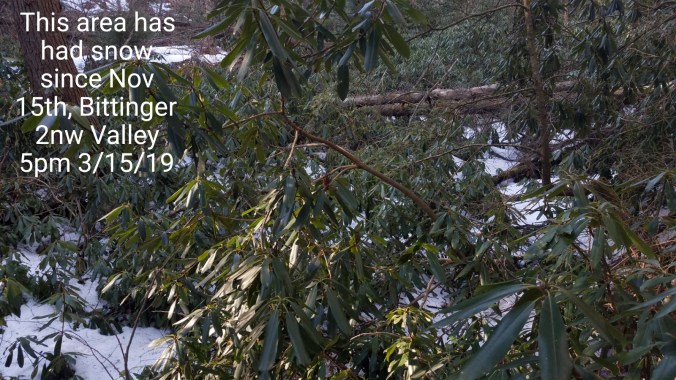
Pics today….before I post them. It’s a good time to touch on the microclimate of these higher sheltered valleys. At Bittinger 2nw Valley last night at 1:30am, the temp had fell off to 38°, a short distance away in a unprotected open valley, Mchenry was 62° with wind. Nearly identical elevation.  These sheltered valleys, see less sun duration, pocket colder air longer, more wind protected often. Leads to a much longer snow cover duration.. Enough so, this first pic here. Sheltered area near Glade Run at Bittinger 2nw Valley… Today being March 15, this spot has had snowcover since Nov 15th. 4 straight months.  This is not piled, drifted or anything. Just a well protected area. 2019-03-15-18-09-55

Other pics

Canaan Cam offline

Mar 14(Thurs)        min     max     avg

Bitt 2nw Valley

Garrett College

New Germany SP

Can-Heights

CRN-Canaan

Cabin Mt

Cabin Mt north

Spruce Knob

Snowshoe

Can-Valley Floor

Can-Valley Floor N

7Springs

Thin clouds, some blue, calm in the morning, light warm breezes in the afternoon. Warmest day since Nov 1.

Temp profile this afternoon

Radar- nothing of significance locally

Satellite

Flow

Surface features and 500mb height anomalies and flow

Pics today

Rt 40 Elementary cam offline

Canaan Cam offline

Mar 13(Wed)            min      max.     avg

Bitt 2nw Valley

Garrett College

New Germany SP

Can-Heights

CRN-Canaan

Cabin Mt

Cabin Mt north

Spruce Knob

Snowshoe

Can-Valley Floor

Can-Valley Floor N

7Springs

Beautiful sunrise then more clouds than sun. Few afternoon sprinkles. I believe there was a few ice pellets briefly.

Temp profile this afternoon

nothing of consequence on radar

Satellite

Flow

Surface features and 500mb height anomalies and flow

Pics today

Deep Creek Lake off the Railey webcam this morning Screenshot_20190313-072306

Rt. 40 Elementary cam offline

Canaan Cam offline

Mar 12(Tues)              min.     max     avg

Bitt 2nw Valley

Garrett College

New Germany SP

Can-Heights

CRN-Canaan

Cabin Mt

Cabin Mt north

Spruce Knob

Snowshoe

Can-Valley Floor

Can-Valley Floor N

7Springs

Mostly sunny day.

Temp profile this afternoon

Radar void

Snow depth- 2-8″ hardpack snow depth in non direct sunny locations at Bittinger 2nw Valley

Satellite

Flow

Surface features and 500mb height anomalies and flow

Pics today