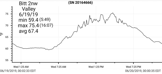
Cloudy, few random morning light showers. A break, a brief temp spoke with a period of sun(not everyone saw, temps reflect it) and some pockets of heavier showers later afternoon
Temp profile this afternoon
Radar
Satellite
Flow
Surface features and 500mb height anomalies and flow
Partly cloudy start, an amazing sunrise…a brief morning shower. Trace is all. A day that featured more clouds than sun, but a pleasant day overall.
Temp profile this afternoon(RTMA will totally miss night time valley temps)
Radar
Satellite
Flow
Surface features and 500mb height anomalies and flow
Pics-
Temps this morning. Northern Canaan Valley dropped to 32.7, before a cloud deck rolled in, this while atop Cabin Mt remained around 50°.. Here’s a look at the numbers
Day began dreary, showery, windy, cold at daybreak. Wv high ground with windchills in 20s. Around mid morning skies rapidly began to break. Remained somewhat breezy, and stayed partly cloudy until late evening as skies cleared further.
Temp profile this afternoon
Radar(not doing great at picking up that early a.m upslope rain)
Satellite
Flow
Surface features and 500mb height anomalies and flow
Pics today
Amongst the weather group last night, there was some discussion of the possibility of flakes at Spruce Knob this morning. It doesn’t appear that panned out. Models were showing 850s around 1°C/33.8F with pockets of precip through daybreak today.
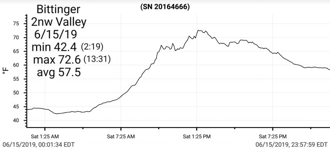
Temp falls this evening- Northern Canaan site dropping rapidly from 8 pm through 10pm. A 9 degree drop in a half hour, 10.6 in 40 minutes after 8pm. The 3km parameters strongly hinted at the possibility of the light winds remaining up on the high ground. The model also modeled these blips of very low dew points. A tipoff that valleys may drop and hold cold before the return flow eventually scours it out. Which, i believe as you’ll see in tomorrow’s post, cloud cover was the main temp moderation from 1:30am the 15th till daybreak. As temps did not jump to match the high ground
3km Parameters
David Carroll from Virginia Tech and his class out in Colorado, high on the Rockies on the continental divide. Reporting many feet of snow remaining and up to 30′ drifts remain
Cloudy, morning showers, some briefly heavy. Then a 3 hour or so break before a return of showers, and increasing winds. Some thunder, lightning and few reports of hail.
Temp profile this afternoon
Radar
Satellite
Flow
Surface features and 500mb height anomalies and flow