December 14, 2019
Dec 14(Sat)
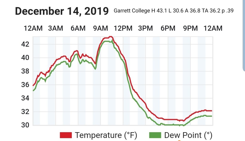
Rainy morning, some pockets of ice in the deep valleys east yet this morning. Cold air changing rain to snow across the high ground midday, afternoon. Light accumulations by nightfall.
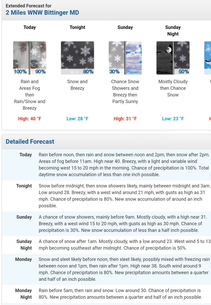
Bittinger 2nw Valley
MIN[30.9]—MAX[42.3]—AVERAGE MEAN[36.6]—TRUE AVERAGE[34.1]

Snowfall season to date 12.3″, will add new tally at recording time tomorrow a.m
Garrett College
MIN[30.6]—MAX[43.1]—AVERAGE MEAN[36.8]—TRUE AVERAGE[36.2]—PRECIP[.39]
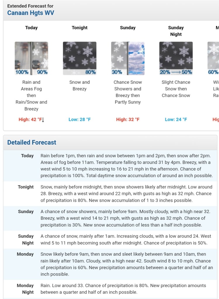
Canaan Heights/Davis 3SE
MIN[27.4]—MAX[44.9]—AVERAGE MEAN[36.1]—PRECIP[.24]7am
Snowfall season to date 20.5″. Todays tally included in tomorrow a.m total
Comments by Dave Lesher
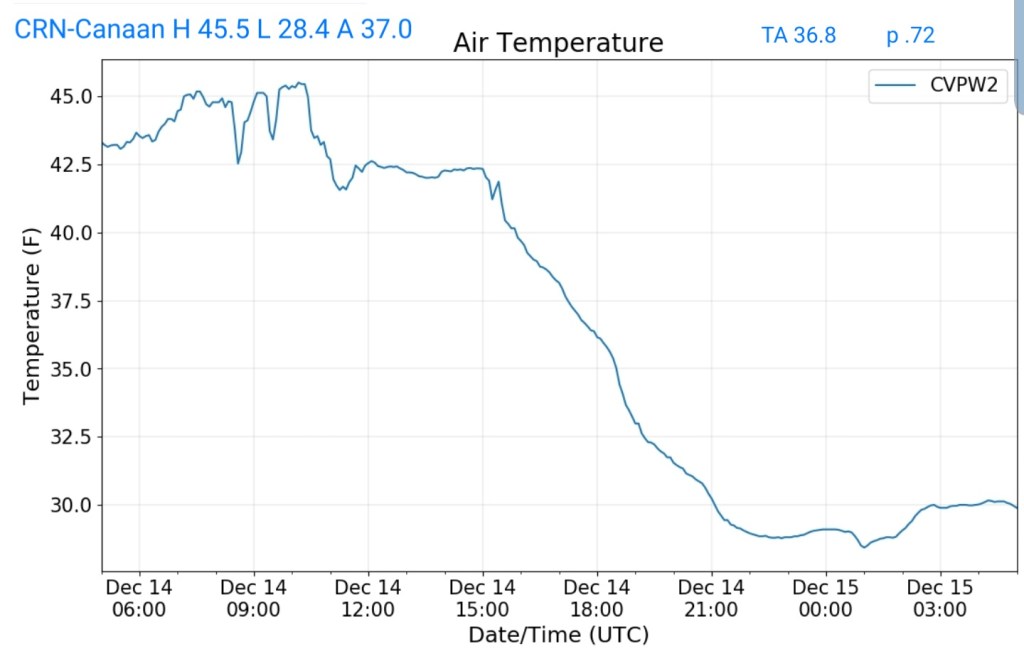
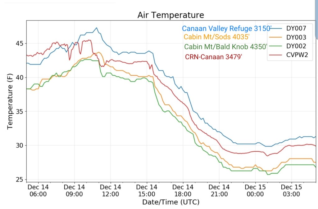
Climate Reference Network Canaan
MIN[28.4]—MAX[45.5]—AVERAGE MEAN[37.0]—TRUE AVERAGE[36.8]—PRECIP[.72]
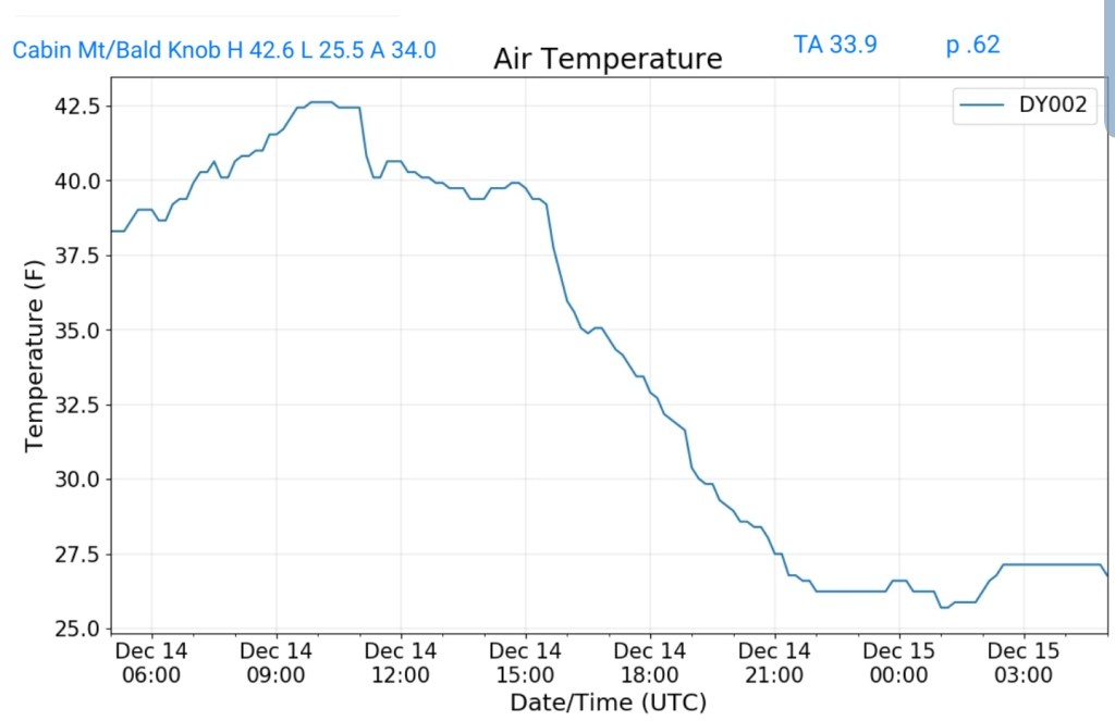
Cabin Mt at Bald Knob
MIN[25.5]—MAX[42.6]—AVERAGE MEAN[34.0]—TRUE AVERAGE[33.9]—PRECIP[.62] *frozen late as with all non heated tipping bucket sites
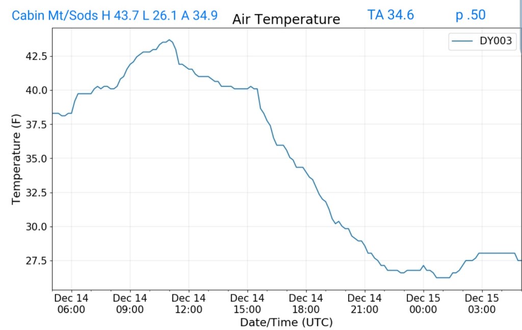
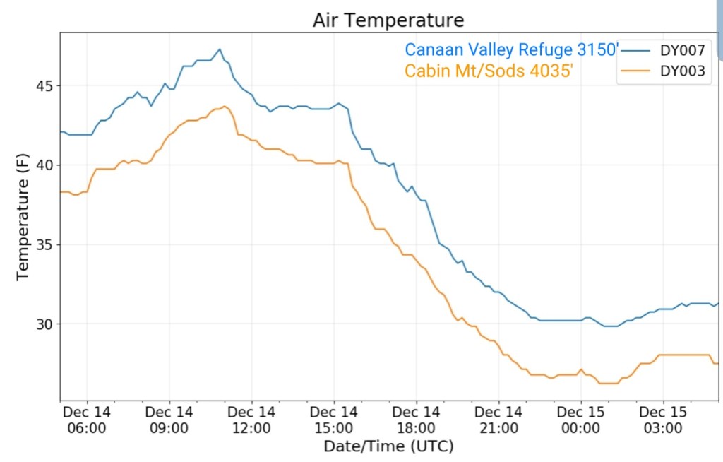
Cabin Mt-Western Sods
MIN[26.1]—MAX[43.7]—AVERAGE MEAN[34.9]—TRUE AVERAGE[34.6]—PRECIP[.50]
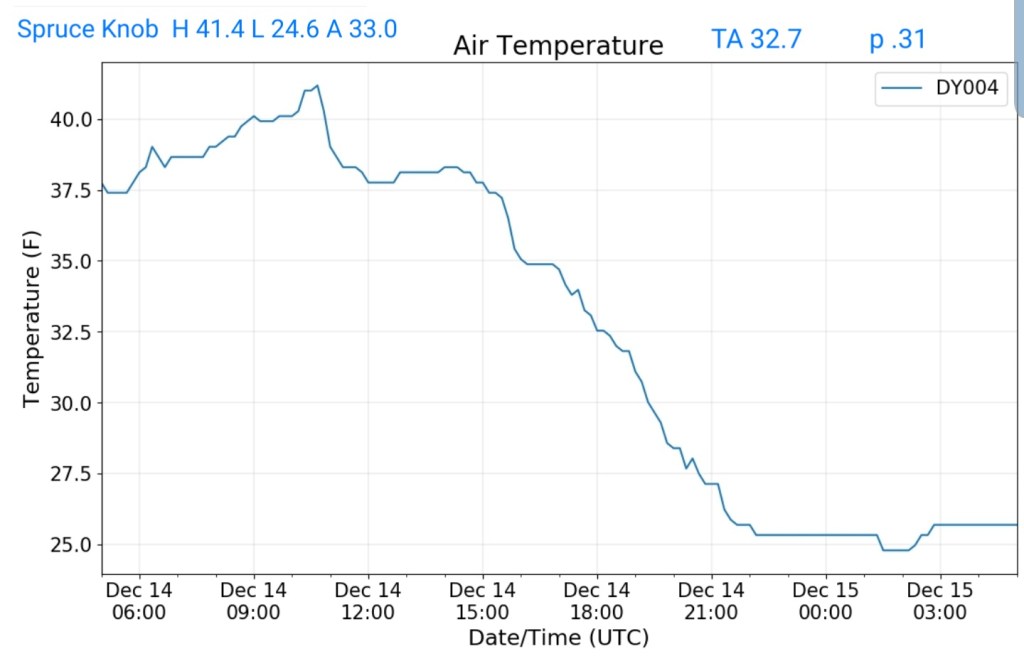
Spruce Knob
MIN[24.6]—MAX[41.4]—AVERAGE MEAN[33.0]—TRUE AVERAGE[32.7]—PRECIP[.31]
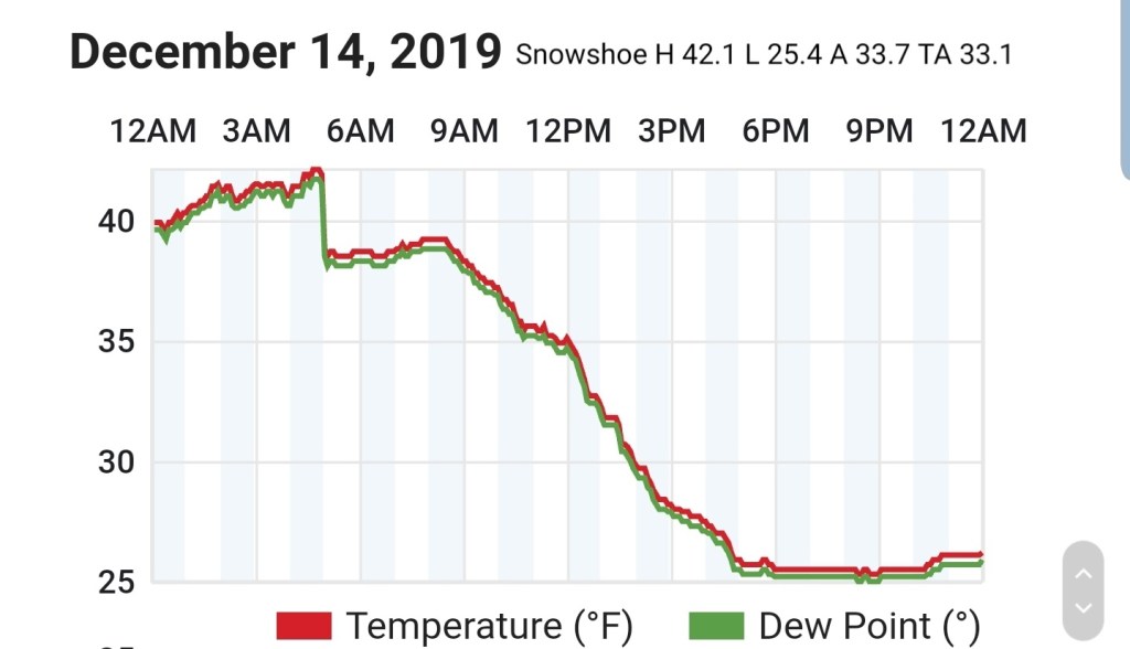
Snowshoe
MIN[25.4]—MAX[42.1]—AVERAGE MEAN[33.7]—TRUE AVERAGE[33.1]
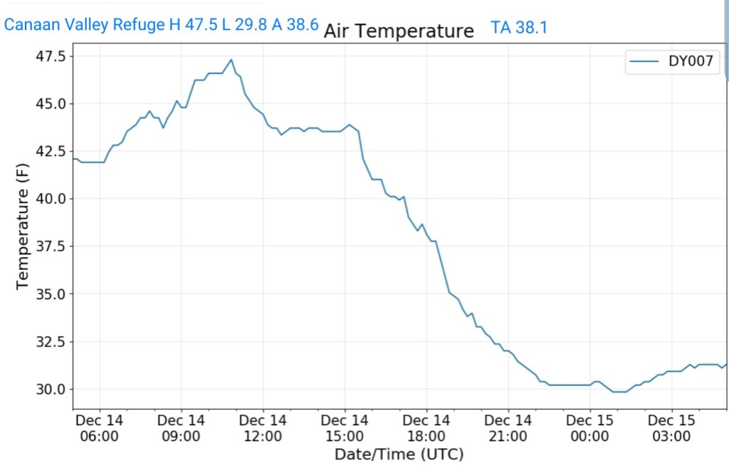
Canaan Valley Refuge
MIN[29.8]—MAX[47.5]—AVERAGE MEAN[38.6]—TRUE AVERAGE[38.1]
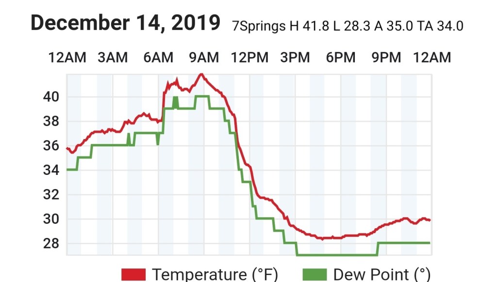
7Springs
MIN[28.3]—MAX[41.8]—AVERAGE MEAN[35.0]—TRUE AVERAGE[34.0]
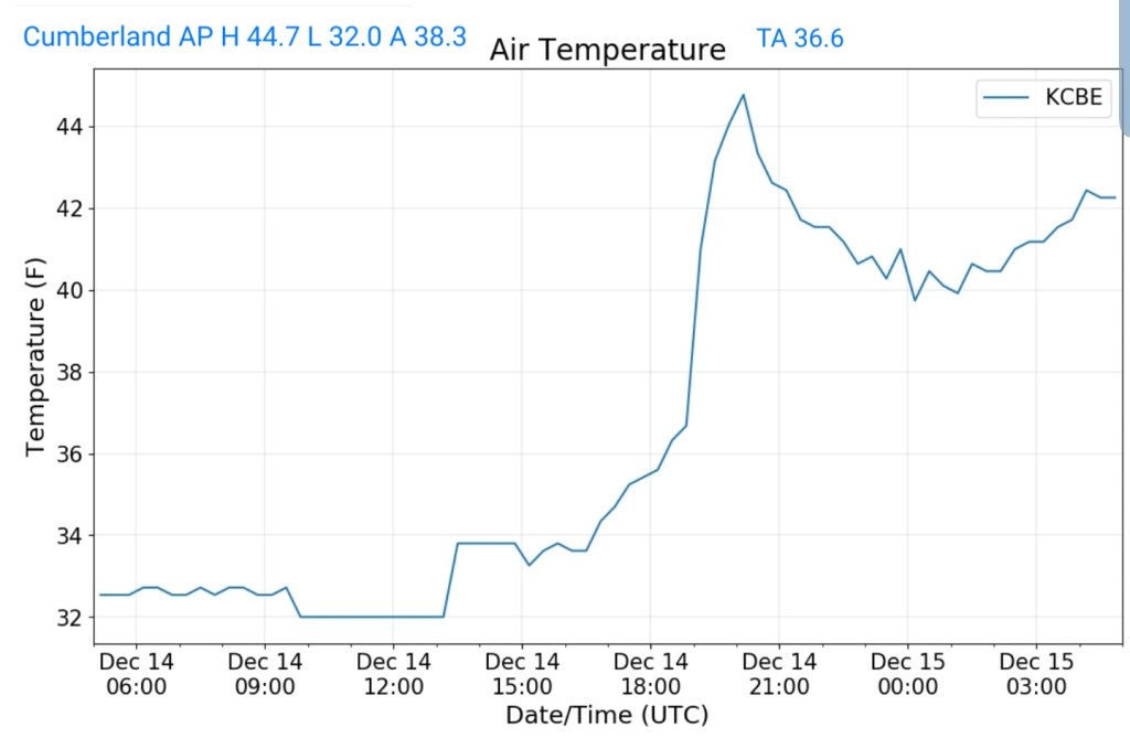
Cumberland Airport
MIN[32.0]—MAX[44.7]—AVERAGE MEAN[38.3]—TRUE AVERAGE[36.6]
The Valley vs Cabin Mt
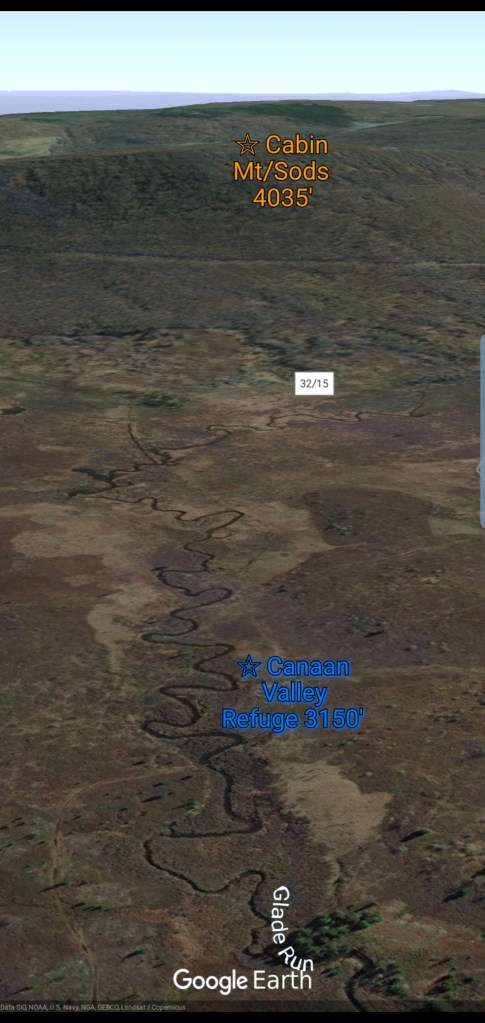
Canaan area temps
Comparison view

RTMA
Radar
Satellite
Flow
Surface features and 500mb height anomalies and flow
Videos today from webcams
Post generated 7am 12/14/19
Icy pockets remain in some of the deeper valleys on the east side of the Alleghenies at the time of this writing shortly before 7am this morning. Traveling in that area, use caution. Otherwise today, we watch for the rain to snow transition as colder air from the west encroaches on the area.
Modeling is generally showing this to occur late morning, early afternoon for the WV high ground, and occurring shortly thereafter north across Garrett, Preston, and the southern Pa high ground.
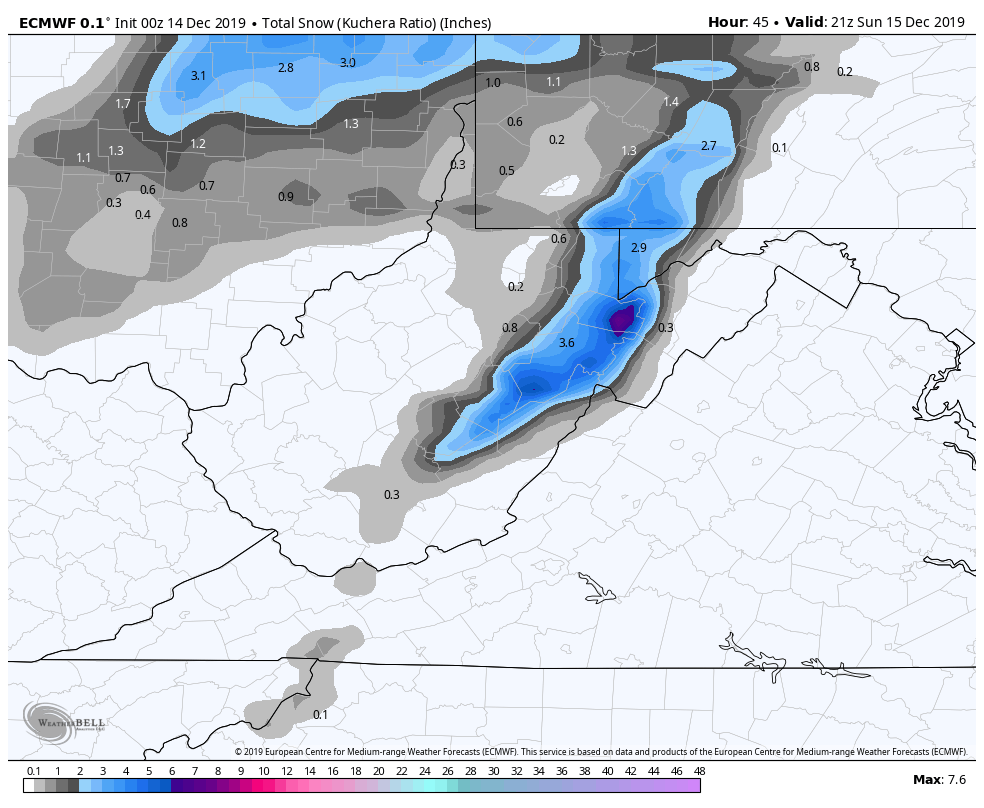
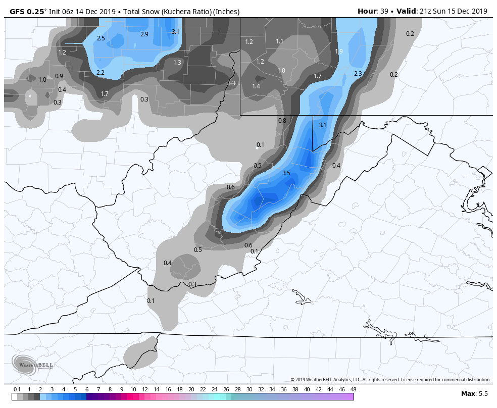
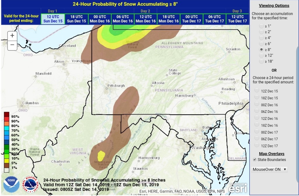
From 12pm today through 4pm Sunday, this appears to be a 3-6″ snowfall for the Wv high ground.(3000’+) As always lean low to mid range and if it performs well, the upper range can be reached. 2-4″ for Garrett, Preston and north into the southern Pa high ground above 2500′. Slightly lower amounts under 2500′. Again, low to mid range looks likely and after some weird forecast last night, the NWS has came around to close to this, but holding it low and at the time of this writing, holding this under winter weather advisory criteria and that may give travelers in this area a false sense of what road conditions will be…
As we go into Monday, the next system is quickly upon us. Once again, the region will be quartered up as some will remain with wintry precip and others to rain.
We all should begin as a round of snow, that transitions briefly to sleet, then to freezing rain and then plain rain.(not all) How long the snow holds on, is a bit of a question mark. It may be a quick brief thump(1-2″) a relaxing in precip, and that allows a warm column to get in aloft SW to NE. This transitions the Wv high ground quickly to a mix and to rain.
However the typical, classic, common, normal, routine, holdouts, The Allegheny Front, this looks to be Spruce Knob and north and duration is longer north, and north central Garrett County, points north, east, this looks to be a duration of a wintry mess. The models will help display that, and if you live here, you’ve seen this play out so many times over the years. This is the high ground and again the lower elevations east involved. Lots of times these systems will hold snow/sleet longer east side of Savage Mt to Frostburg and Lavale with greater accumulations there, than say Grantsville. (Sleet looks minimal with this particular event)That’s something to watch for Monday.
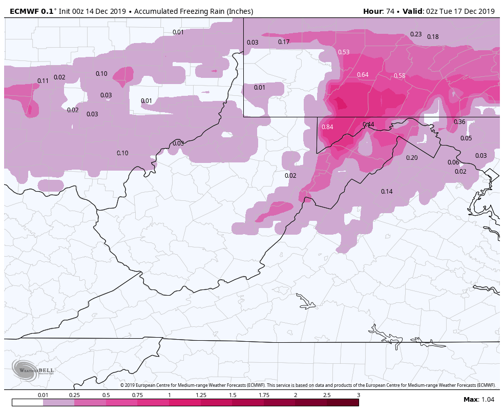
Ice accretion does look to be a concern from the Bittinger area, and points east, north east. Especially the high ground and east facing areas as a strong east wind occurs during this time. With a strong east wind, temps do not just magically spike above freezing. The common NWS error is to forecast the warm air into the typical freeze zone much to soon. Sometimes anywhere from 2 hours to 12 hours to soon. Granted, things have time to adjust yet, but already their Monday forecast looks too soon to rain. I would rather, in these instances have a forecast call for ice a little longer(Tuesday a.m even) than expected for safety purposes in which what winter forecast are for than call for it to end sooner than it does than put people out in about making plans while conditions are still poor.
So, let’s jump to the models. Both the weekend event and early week included:
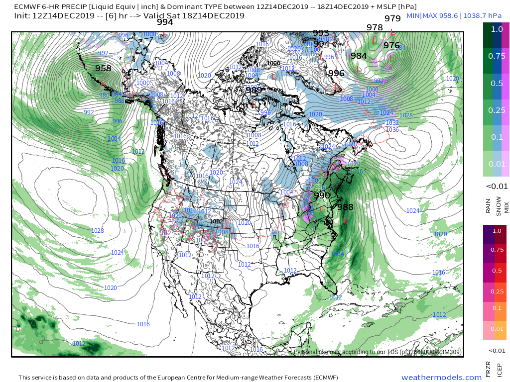
0z ECMWF
2M Temps
MSLP/6HR/PRECIP TYPE
10m Wind Gust
Snowfall through the weekend event
Ice through the Monday event – too note, this is likely overdone.
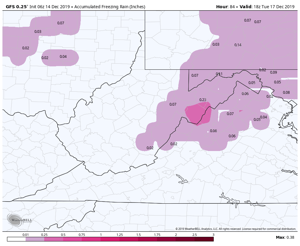
6z GFS
2m Temps
MSLP/6HR/PRECIP TYPE
Snowfall amounts off the weekend event
Ice through the Monday event-looks underdone
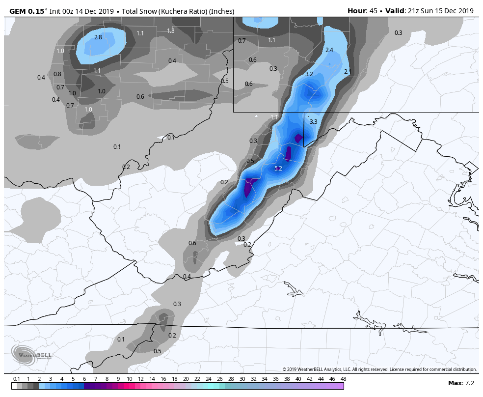
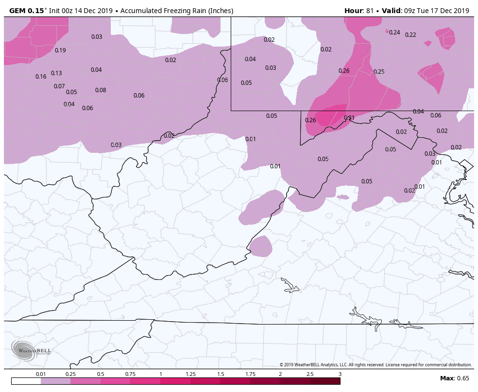
0z Canadian
2m Temps
MSLP/6HR/PRECIP TYPE
Snowfall off the weekend event
Ice for the Monday event
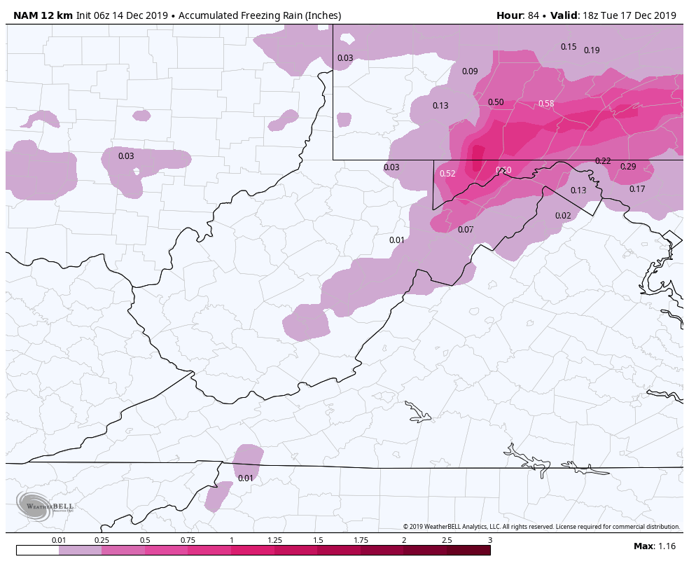
06z 12km Nam
2m Temps
MSLP/6HR/PRECIP TYPE
Snowfall off the weekend event-Nam is notorious for putting out to much liquid with systems. Not a strong suit of the model
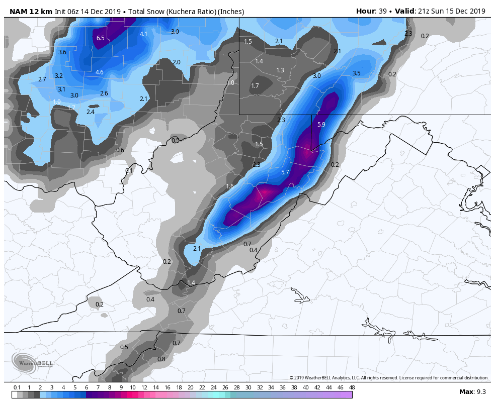
Ice for the Monday event. Having said about to much liquid with systems, by that I mean precip in general, the Nam does agree some with the ECMWF with this event. Saying is, when then NAM and ECMWF , pay attention
6z ICON
This model is up there with the Nam in handling temperatures with these east flow/cold air damming events
2m Temps
adding the wind streamers with temps, that east flow Monday. Again, those classic areas, temps do not magically rise very fast.
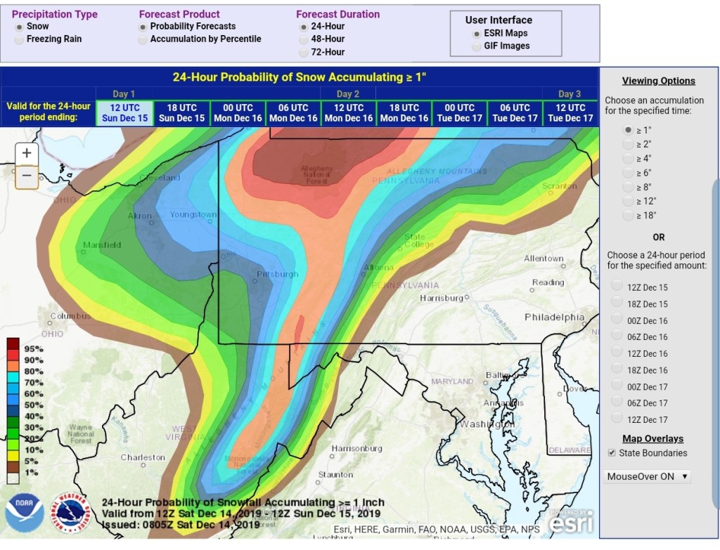
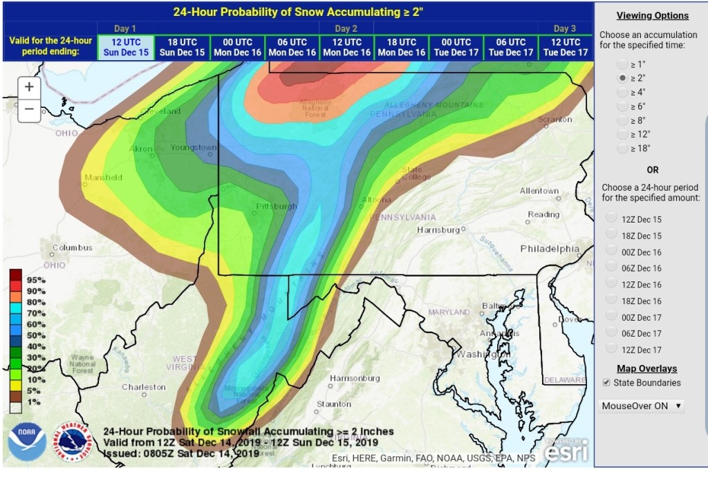
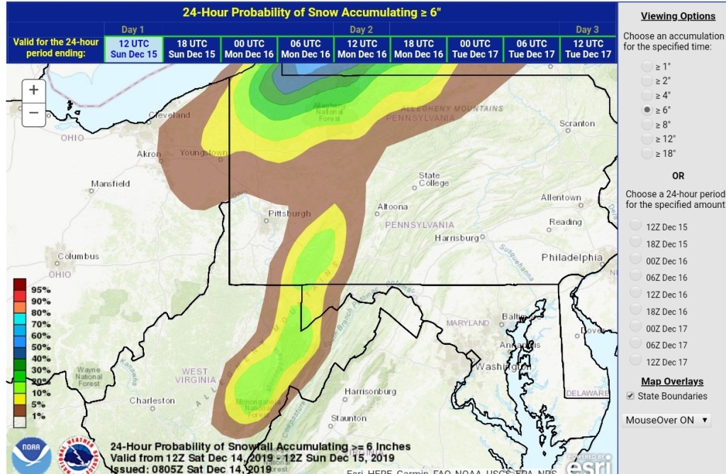
Let’s hop to the WPC outlook for the snow event this weekend and ice early week.
Snowfall probabilities

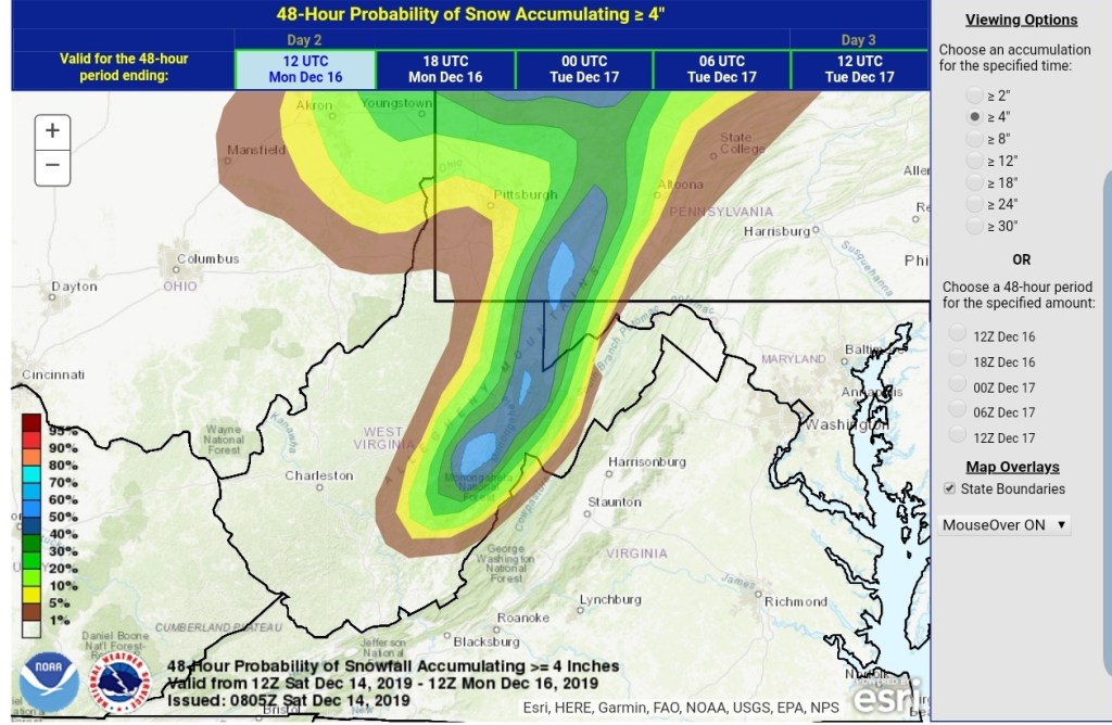
48 hr 4″ probability
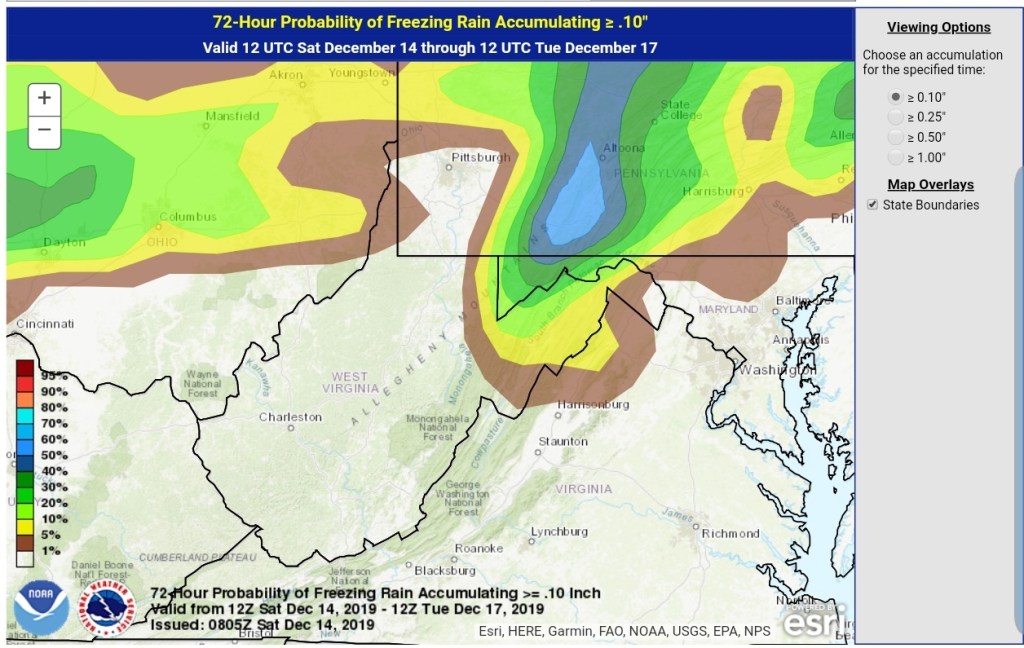
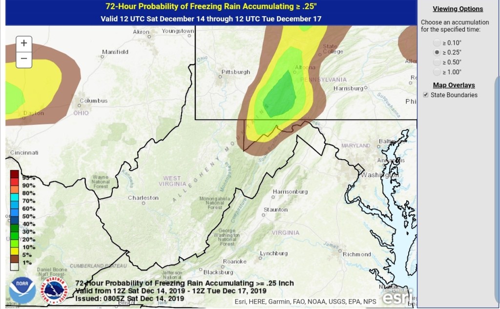
WPC Ice potential
.10
.25
.50

New NWS forecast, wording is much improved for the weekend event, over the strange wording from last night.
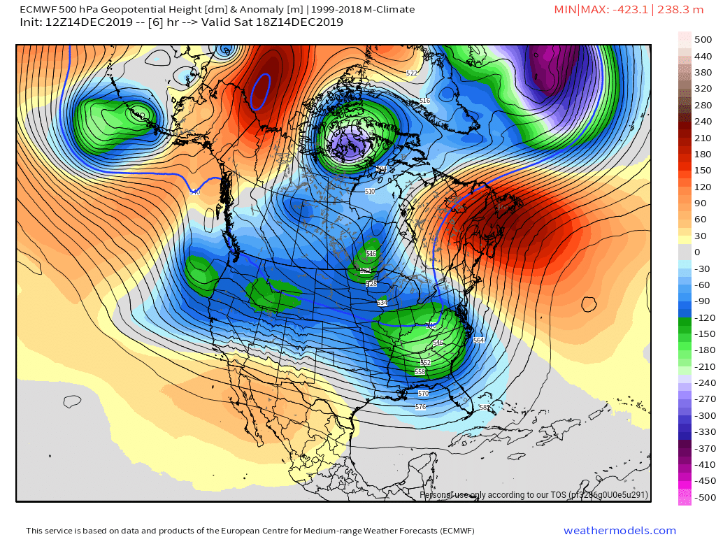
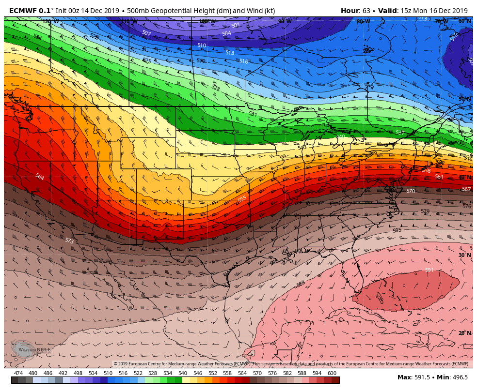
Few weeks ago I made a post about this, freezing rain to rain to snow pattern. Its held. Several years ago Bob Leffler had told me, he was taught to watch the 500mb heights off Miami. When you see that ridge build, do not plan on a consistent snowy pattern in the Wv high country, and basically look for what we are seeing with this current pattern. The SW flow aloft is not conducive for anything more than brief hots of snow, cold, followed by a warm intrusion aloft with the following system and repeat. Well, that rule, which I would call it a rule, has worked nearly 100%.
Heres the 500 for early week
590 heights off Miami is not what you want to see in the WV high ground if you want winter to hold its ground
That said, there are signs this relaxes and other teleconnections become more favorable down the road. Unfortunately, models just aren’t that good at it. This year, the setup is very December 2013ish. Without the blowtorch days…and we all should remember where January 2014 went…
