Feb 4(Tues)
Cloudy, breezy day, temps were mild. Scattered light showers.
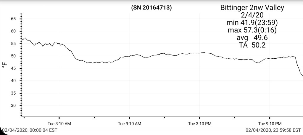
Bittinger 2nw Valley
MIN[41.9]—MAX[57.3]—AVERAGE MEAN[49.6]—TRUE AVERAGE[50.2]
Snowdepth- Trace and patchy
Snowfall season to date 39.4″

Garrett College
MIN[43.1]—MAX[57.7]—AVERAGE MEAN[50.4]—TRUE AVERAGE[50.4]—PRECIP[.18]

Canaan Heights/Davis 3SE
MIN[44.0]—MAX[54.0]—AVERAGE MEAN[49.0]—PRECIP[.07]7am
Snow depth 2″ 7am
Snowfall season to date 52.6″
Comments by Dave Lesher at:
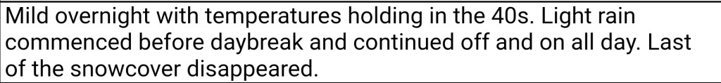
Climate Reference Network Canaan
MIN[44.8]—MAX[57.2]—AVERAGE MEAN[50.5]—TRUE AVERAGE[48.3]—PRECIP[.36]
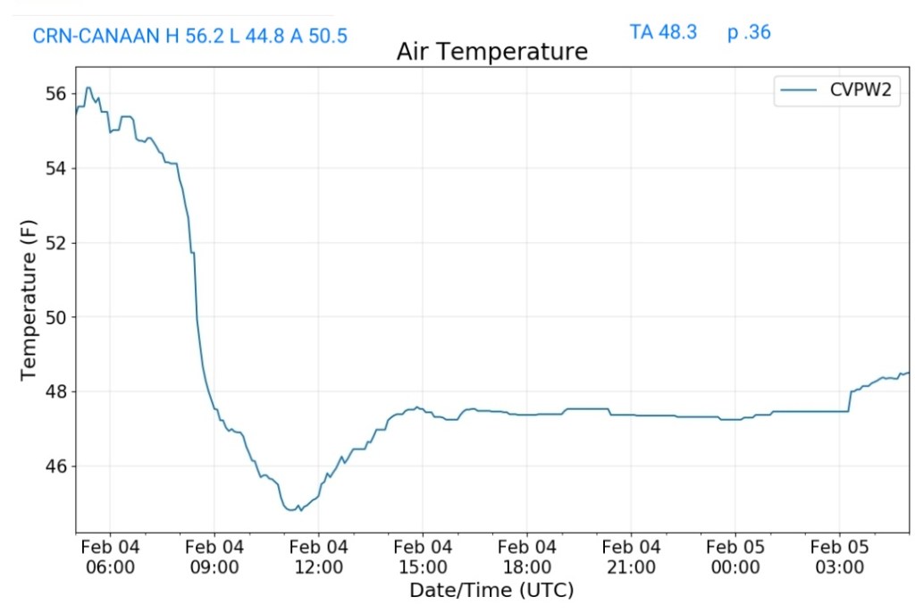
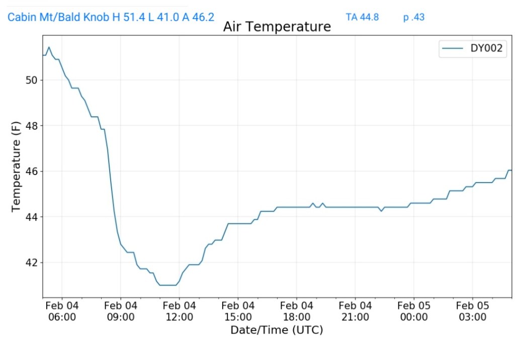
Cabin Mt at Bald Knob
MIN[41.0]—MAX[51.4]—AVERAGE MEAN[46.2]—TRUE AVERAGE[44.8]—PRECIP[.43]
Cabin Mt-Western Sods
MIN[41.7]—MAX[53.1]—AVERAGE MEAN[47.4]—TRUE AVERAGE[45.7]—PRECIP[.25]

Spruce Knob
MIN[40.6]—MAX[49.3]—AVERAGE MEAN[44.9]—TRUE AVERAGE[43.8]—PRECIP[.11]

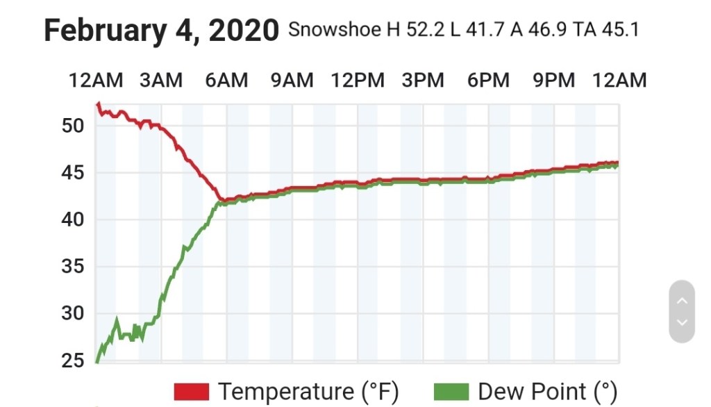
Snowshoe
MIN[41.7]—MAX[52.2]—AVERAGE MEAN[46.9]—TRUE AVERAGE[45.1]
Canaan Valley Refuge
MIN[45.5]—MAX[55.9]—AVERAGE MEAN[50.7]—TRUE AVERAGE[49.4]

7Springs
MIN[31.3]—MAX[55.9]—AVERAGE MEAN[43.6]—TRUE AVERAGE[46.8]

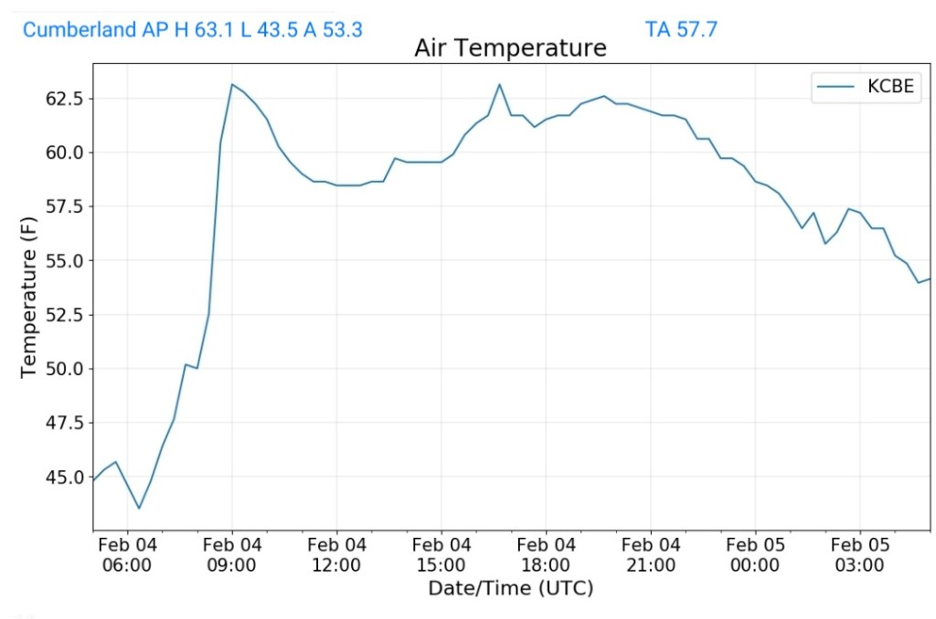
Cumberland Airport
MIN[43.5]—MAX[63.1]—AVERAGE MEAN[53.3]—TRUE AVERAGE[57.7]
The Valley vs Cabin Mt

Canaan area temps
Comparison view

RTMA
Radar
Satellite
Flow
Surface features and 500mb height anomalies and flow

February 4, 2020

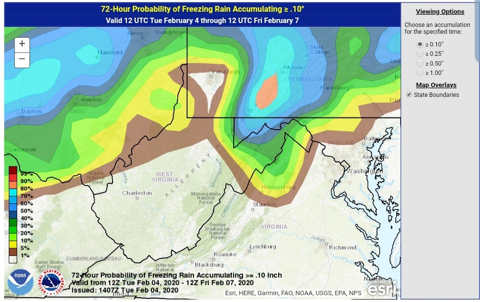
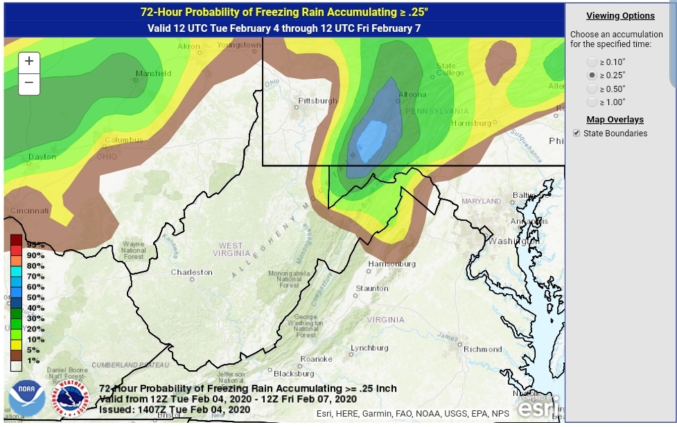
As we go through the overnight and into tomorrow, colder air works in from the north. This continues into the overnight Wednesday. Later in the day Wednesday into the very early hours of Thursday, parts of the area look to be in the freezing rain scenario. It’s those same typical locations that should see the longest duration of freezing rain. The duration being from later tomorrow into Thursday a.m. It would not he surprising, but more likely will be expected to see some winter weather advisories issued by the NWS for later Wednesday through 7am Thursday for Garrett and points east, northeast.
Ice amounts to me look limited in most areas. From the Bittinger area and east from Meadows Mt to Savage Mt and to Dan’s Mt, south to Mt Storm, north into Somerset County , looks like the greatest risk to pick up potentially .1 to .3 ice. Due to marginal temps, and overall a short duration of the event, anything potentially higher than .3 would be on the exposed east facing ridges in this area as east winds look to be gusting at this time and that aids in freezing on contact much faster with temps 28-32 than areas not impacted by the wind.
Road issues will likely be minimal, but as always with ice, it may look wet and in reality, its ice. Use caution.
WPC OUTLOOK
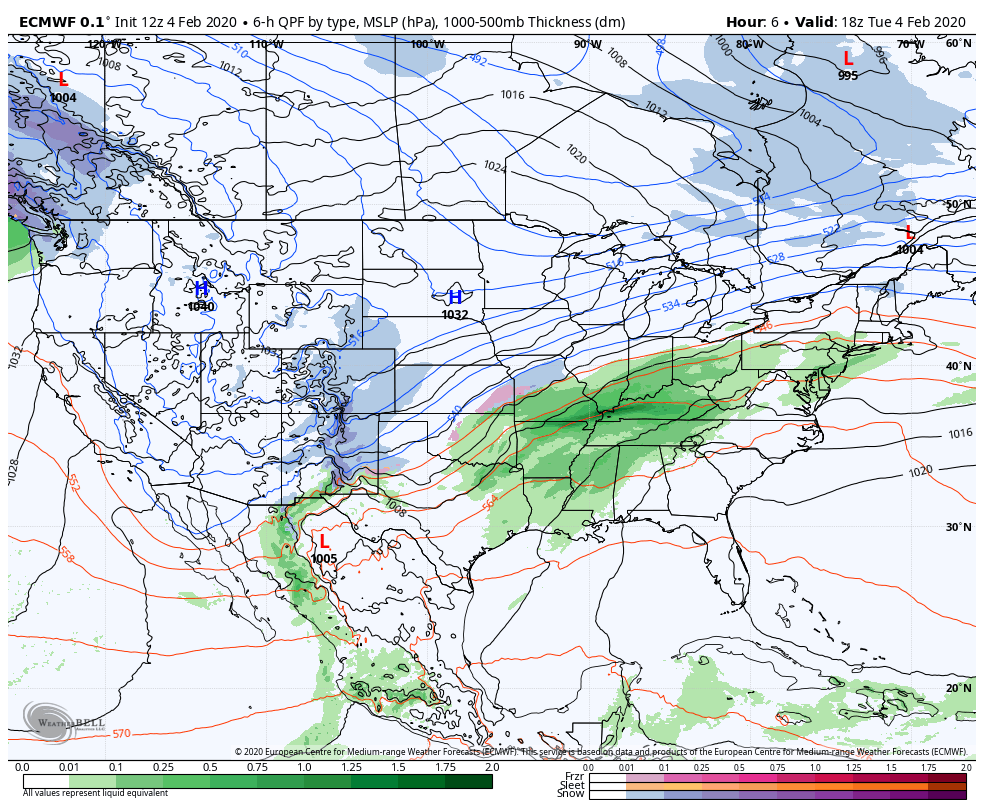
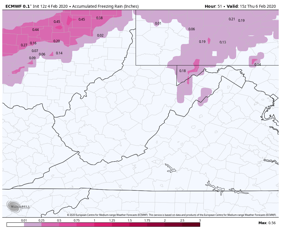
12z Euro
(Probably a touch more widespread than this)
PITT/STATE COLLEGE/STERLING NWS
Overall that looks good, below 2500, maybe a touch high.

The duration is brief, its rapidly out Thursday morning. Like clockwork the east wind dies, a moment of calm weather creeps in, for a hour temps slowly rise into the mid 30s early Thursday then with a snap, SW winds blow in rapidly seeing temps fly into the 50s and the ice will quickly become a memory.
Just as fast as the warmth comes back in, rain will encroach and temps will begin falling overnight Thursday and by Friday morning accumulating snow returns. As we go through the day Friday, looks like light to moderate accumulation of 2-4″ may be likely. That will be accompanied by strong gusty winds, 20-40mph with blowing snow and temps falling into the 20s, with teens by late afternoon across the Wv high ground.
After that a lull Saturday with more accumulation potential Saturday night.
