January 31, 2023

January 31, 2023

Forest Service Cam offline since 6/24/21

Jan 31(Tues)

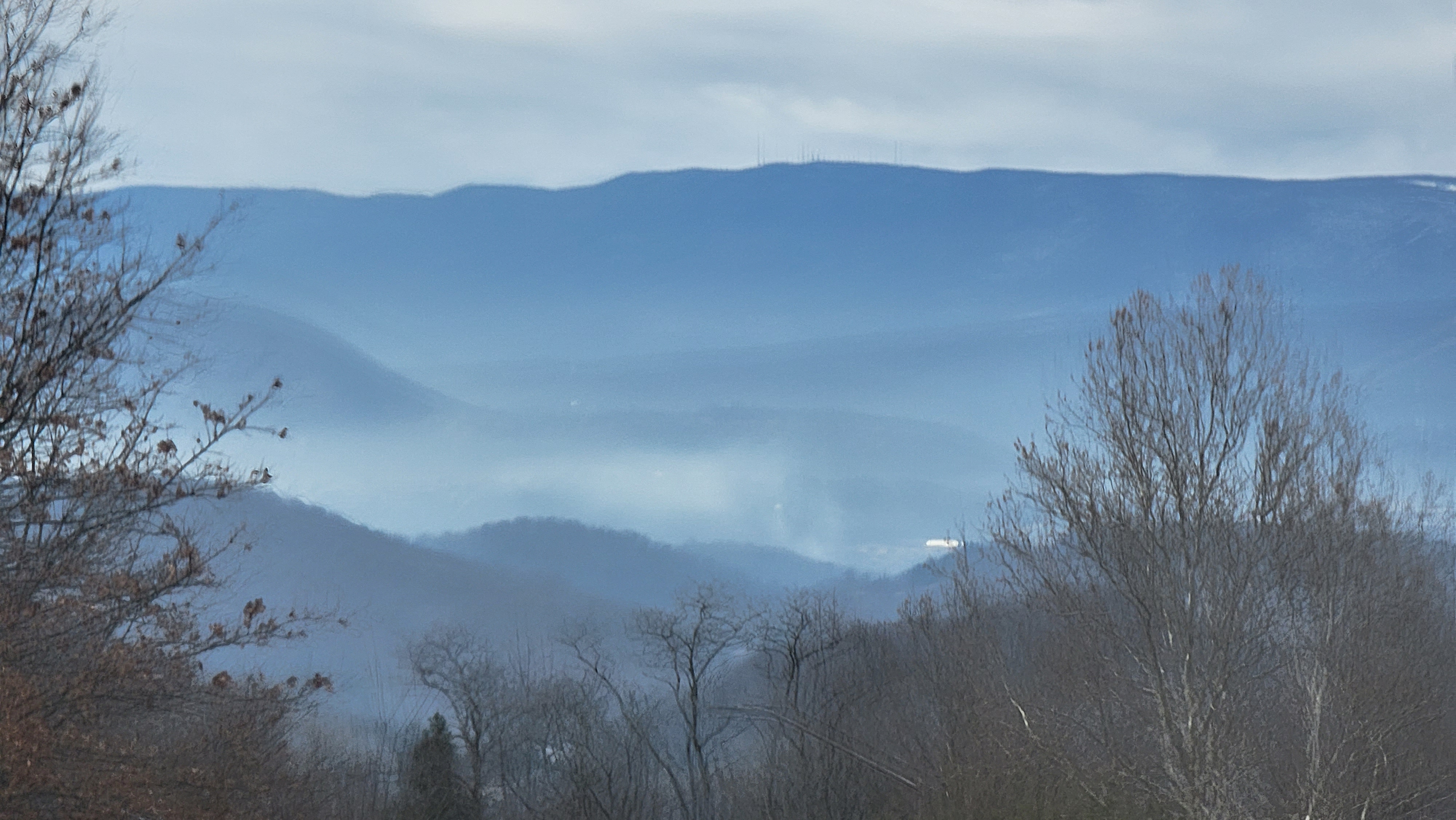
On and off light snow with pockets of freezing drizzle. Some areas of fog as well.

  • automated tipping bucket stations will not have accurate precip amounts during periods of freezing weather- Bald Knob, Canaan Ski area, Western Sods, Spruce Knob, Mt.Davis, Top of Wisp, Davis 3SE Dyacon-coop is accurate

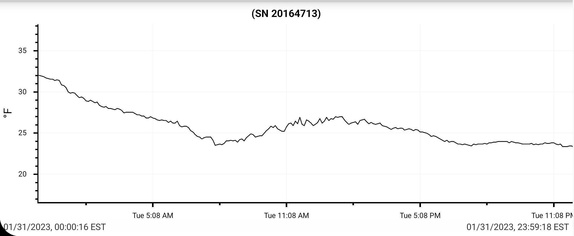
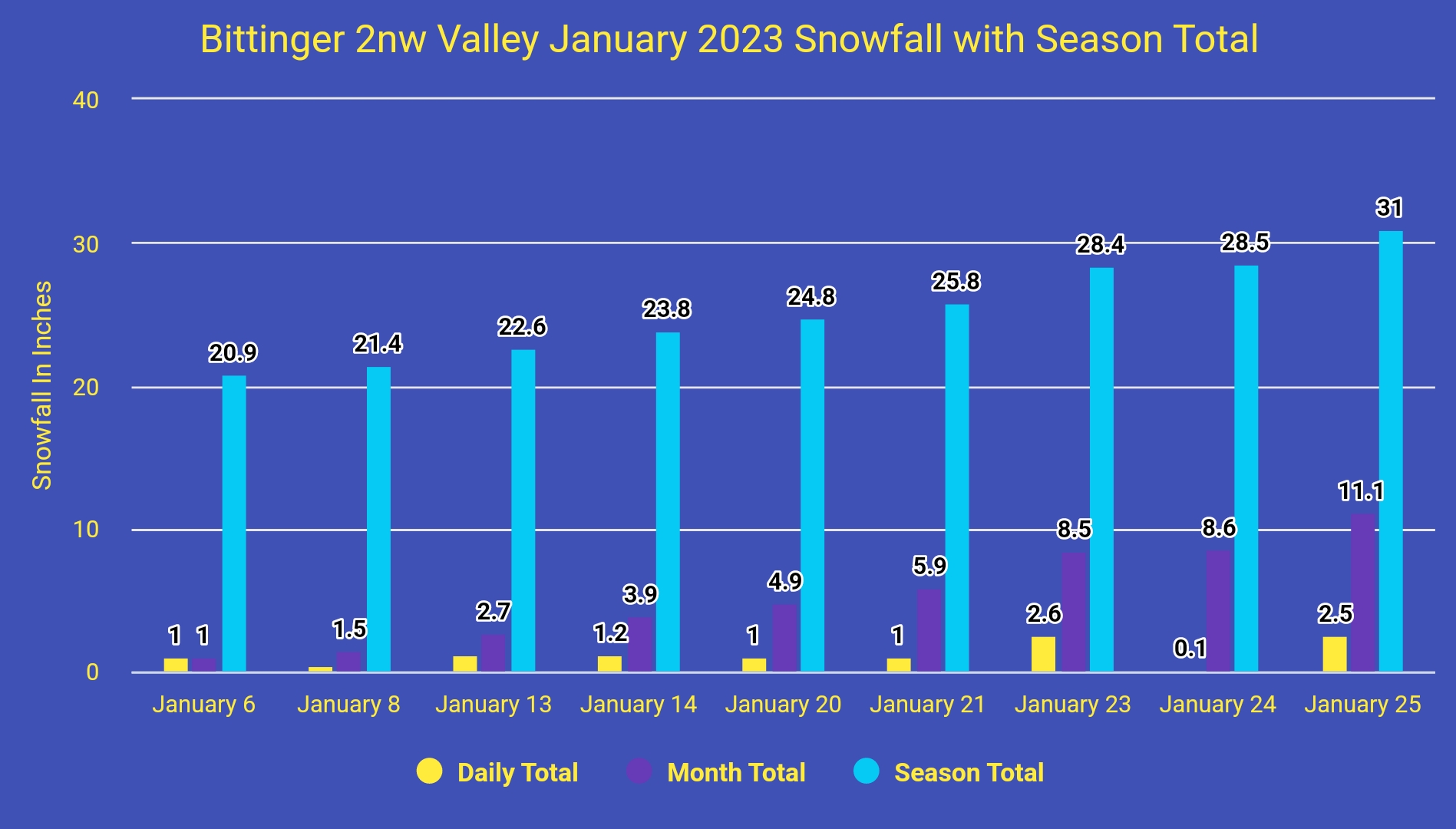
Bittinger 2nw Valley

  • MRD-Max Recorded Depth. I tried to capture that at what time in the day it occurred.
  • T, Trace without 100 feet of recording site. I-T, Isolated trace outside of 100 feet but within 1000 feet of recording site.
  • The + symbol under precip. That symbolizes precip occurred after 5pm but precip did occur on the date. If it follows a tally it simply means more occurred beyond 5pm. It also was used at time when precip was occurring at 5pm and I needed to do a melt but waited until the system was finished. On rare occasions I was not there at 5pm to record and plugged it in the following day. All precip was recorded
  • The down arrow by the max represents a midnight max temp. Which occurred frequently.
  • Temp recording time is midnight to midnight
  • Precip recording time 5pm to 5pm
  • Snowfall- boards sweeps occur at 7am and 5pm. Max daily snowfall is still captured when it occurred and not only measured at 7am and 5pm
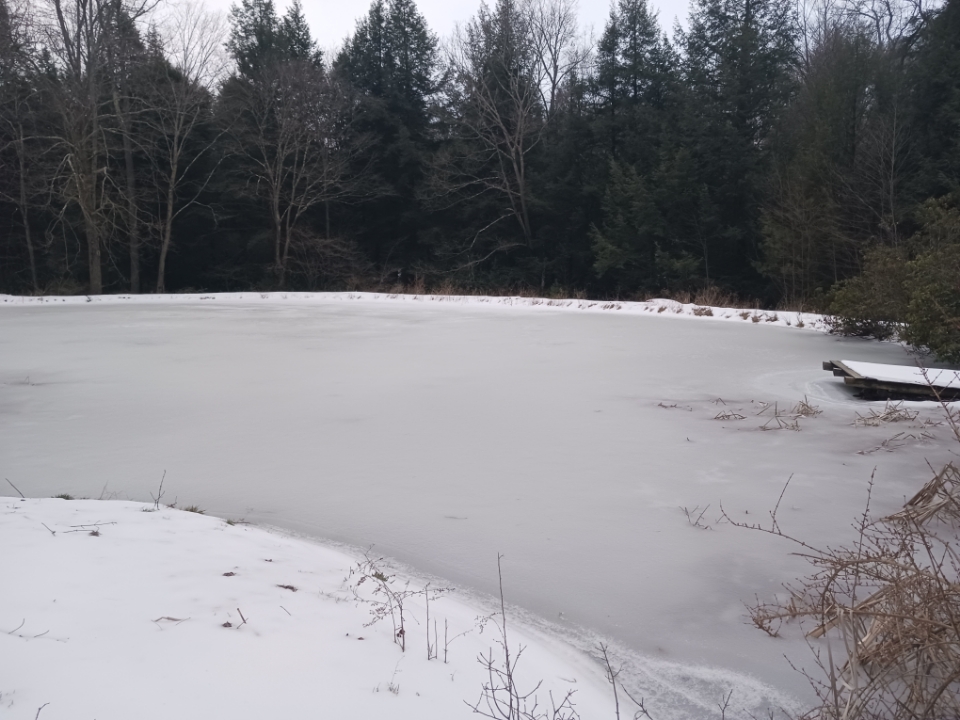
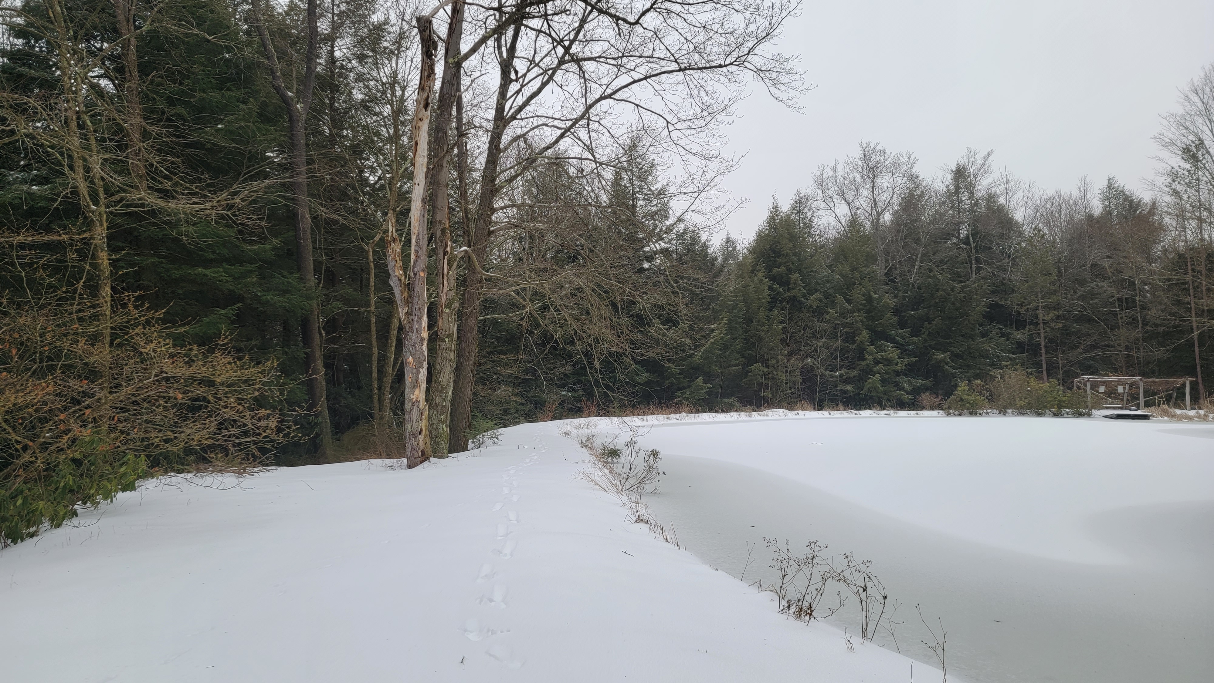
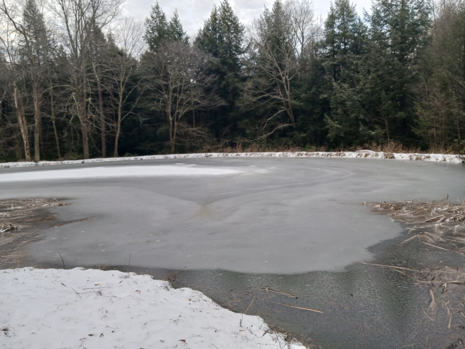
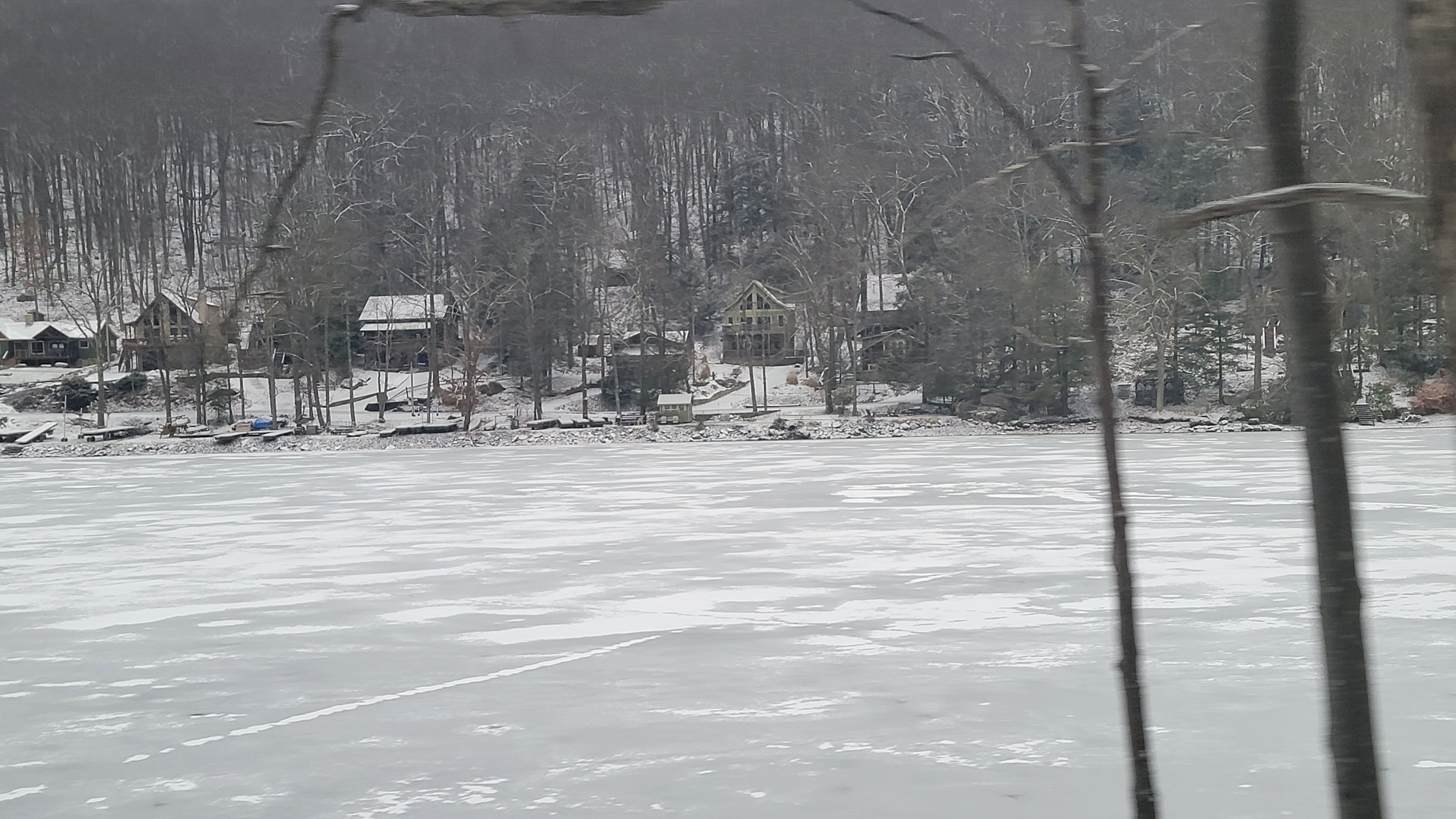
  • Note- pond remained iced over for the entire month despite milder than normal weather
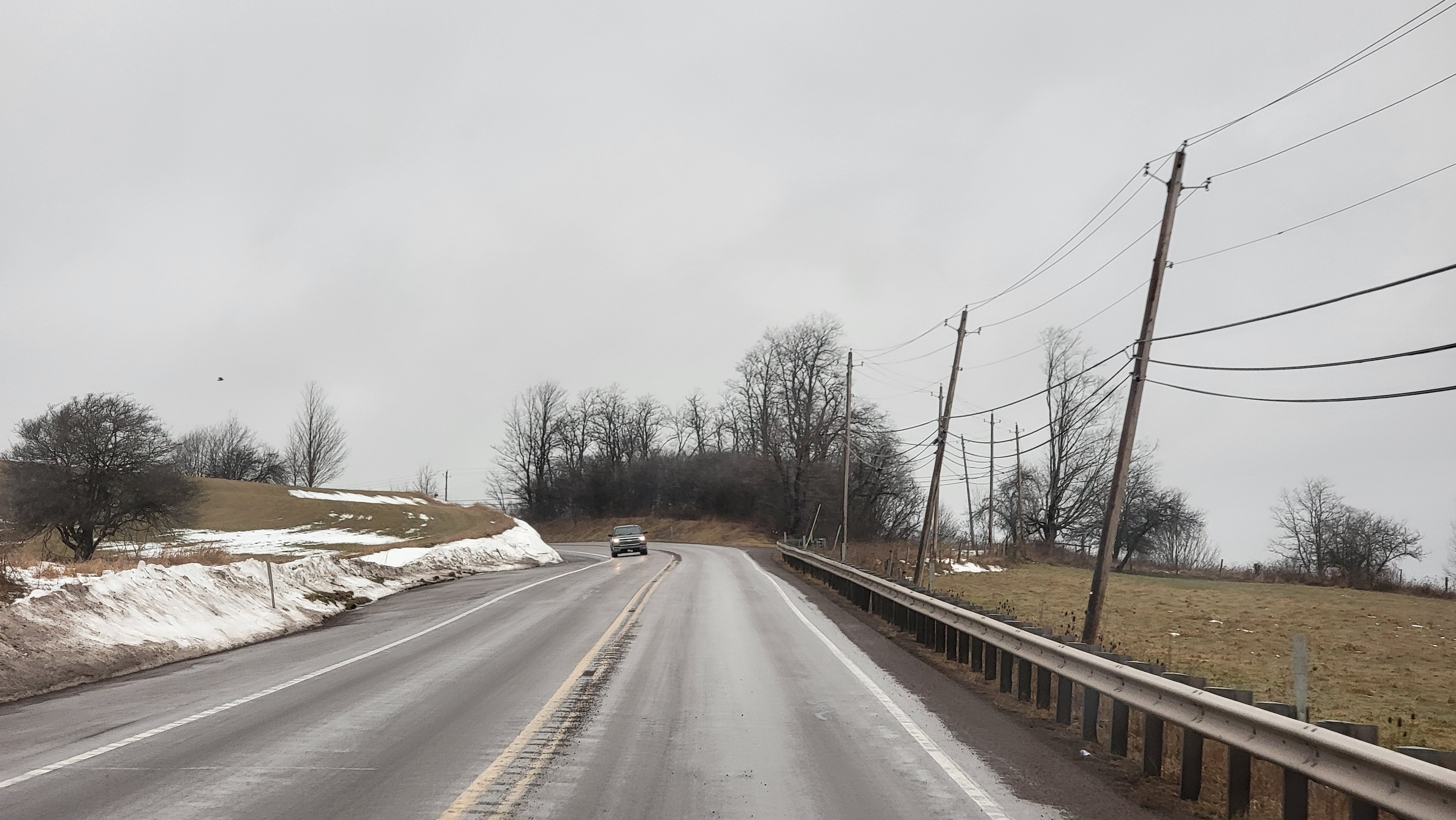
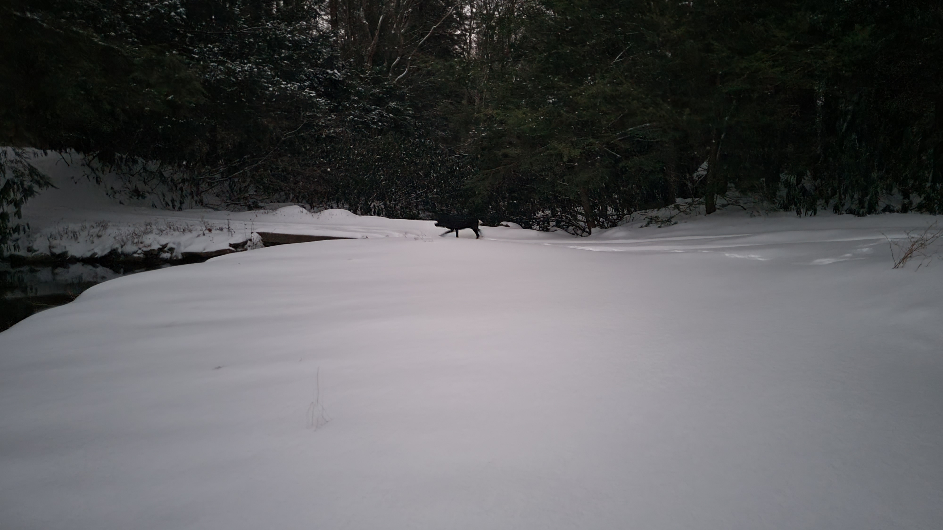
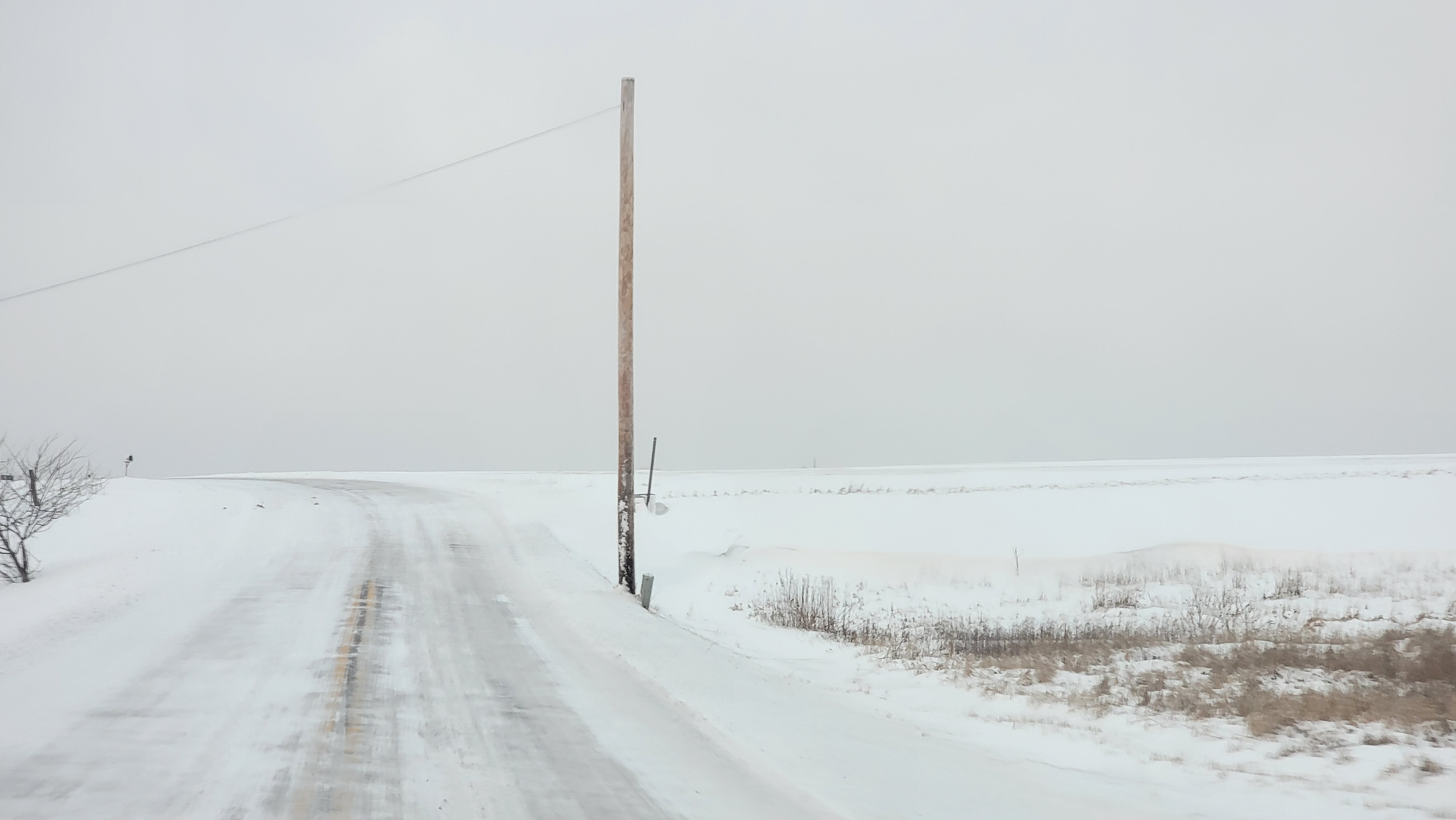
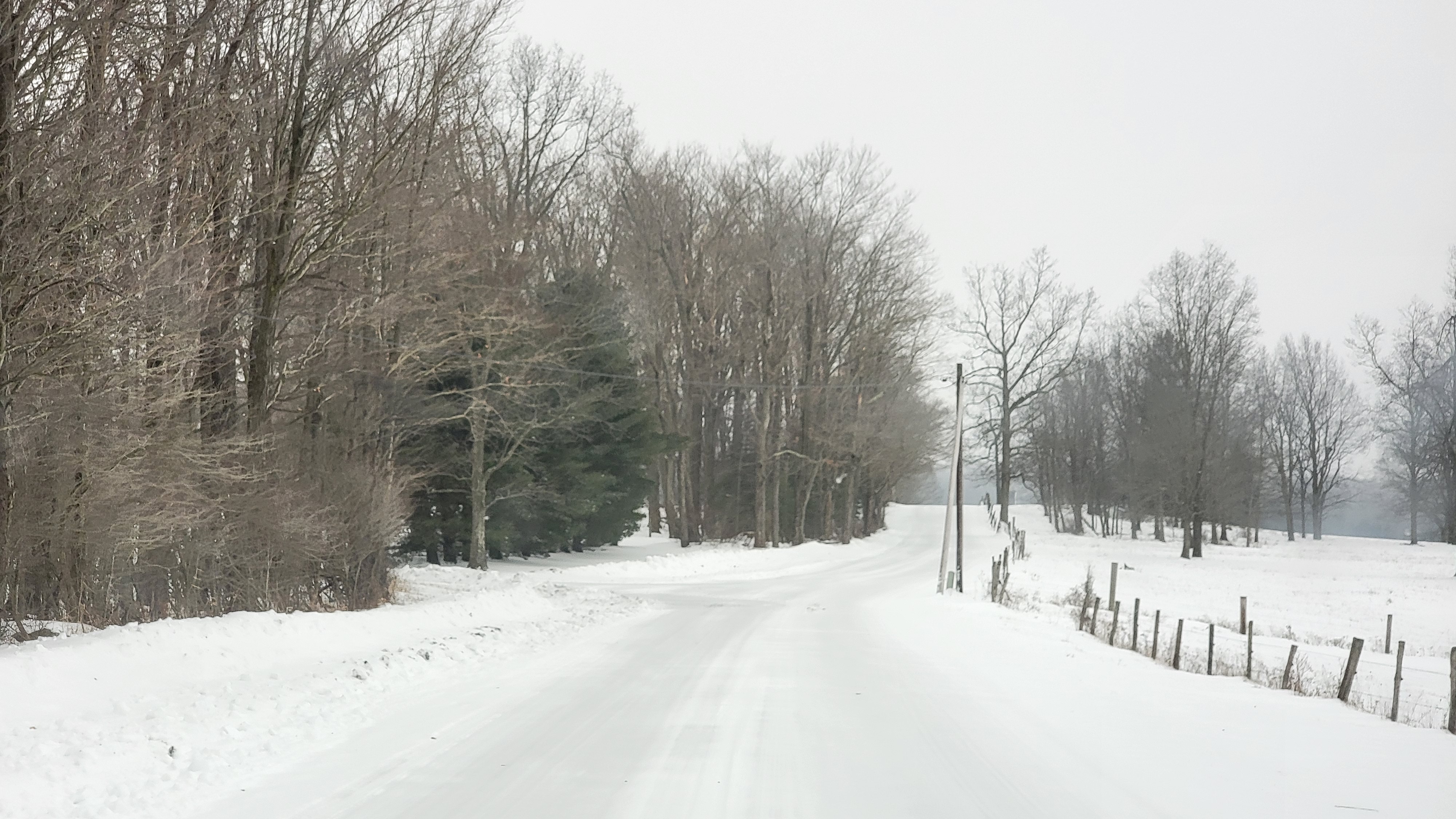
Foxtown Rd morning
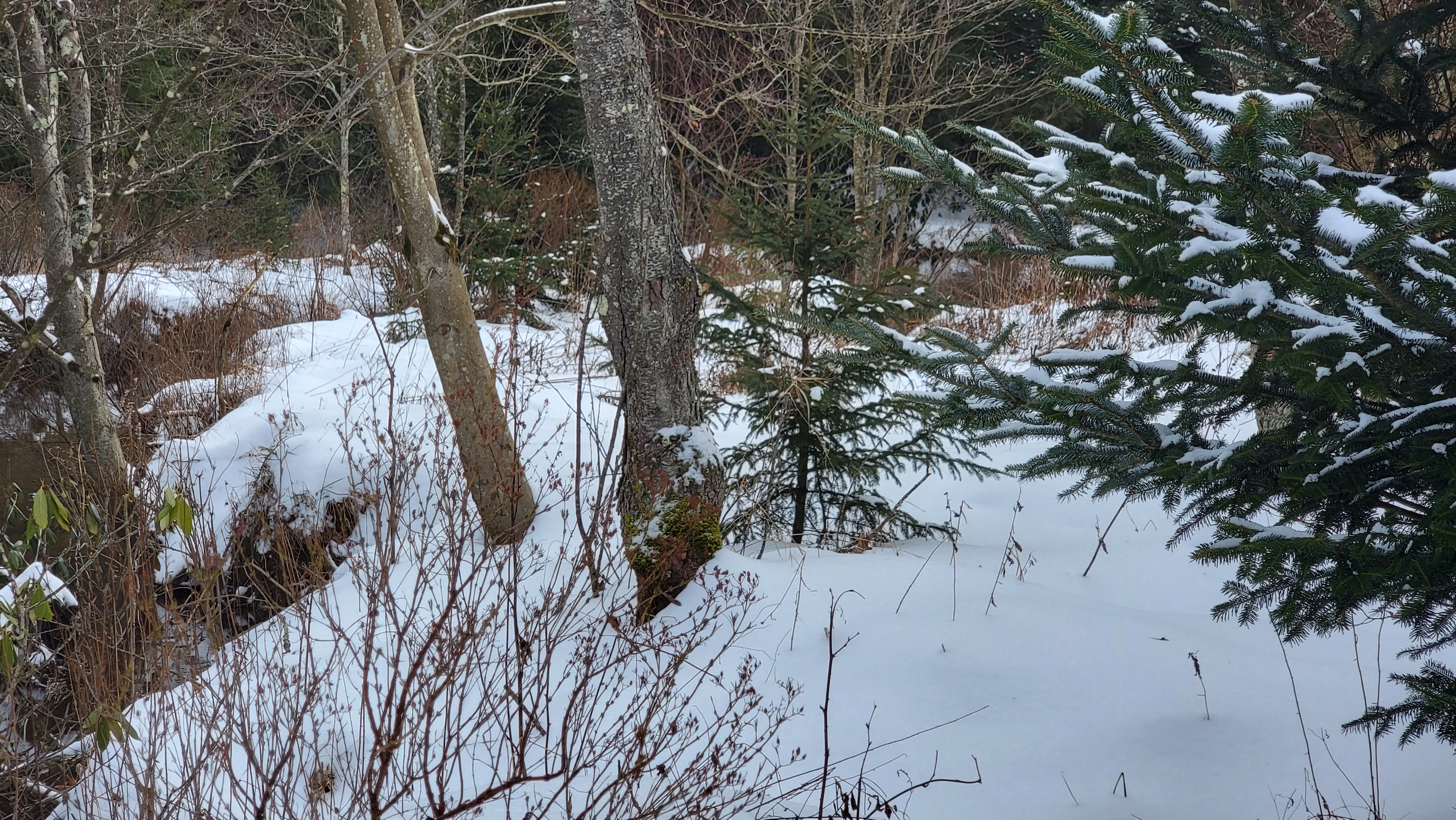
Bittinger 2nw Valley morning
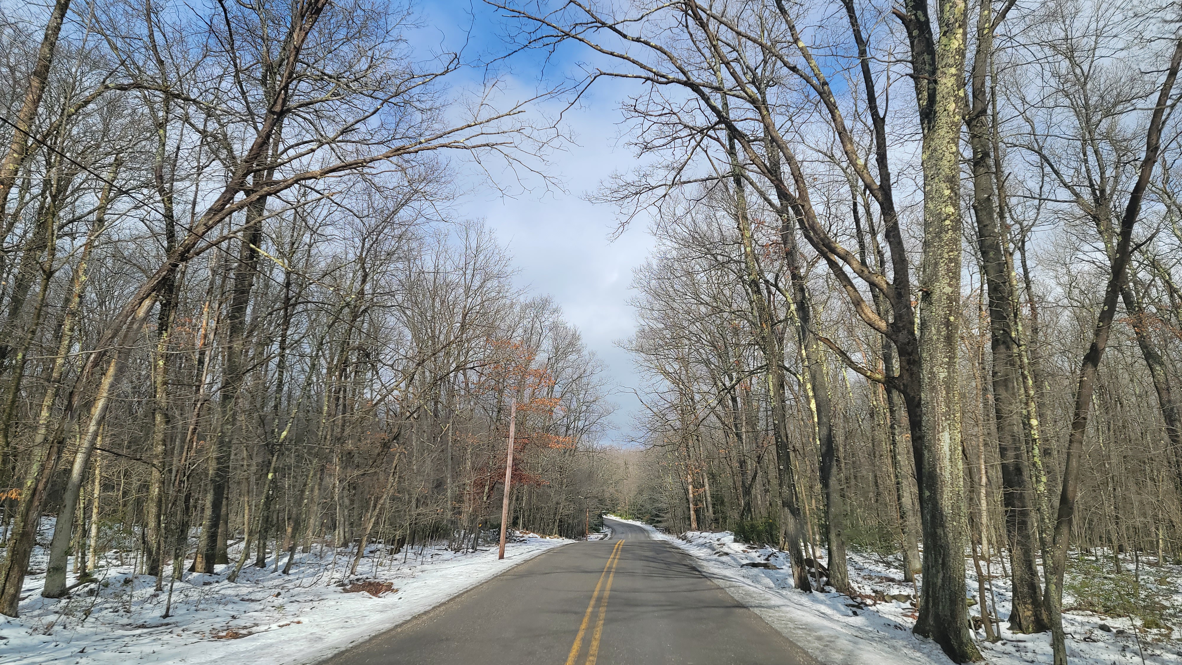
Foxtown Rd morning
west of Bittinger afternoon
Bittinger 2nw Valley afternoon
Bittinger 2nw Valley afternoon “Fridge Spot “
  • Experimental spot for microclimate data for future use
  • As expected, being a low laying sheltered area with hemlock, the maxes remain cooler. With a snow cover, a shaded, and limited wind location, cool air moves down the Valley and holds it ground the longest here. Snow cover greatly enhances that, but it still occurs otherwise. Min temps however are typically higher with the canopy cover except when mild air overnight is in play with a snow cover.
Bittinger 2nw Valley afternoon
Bittinger 2nw Valley evening
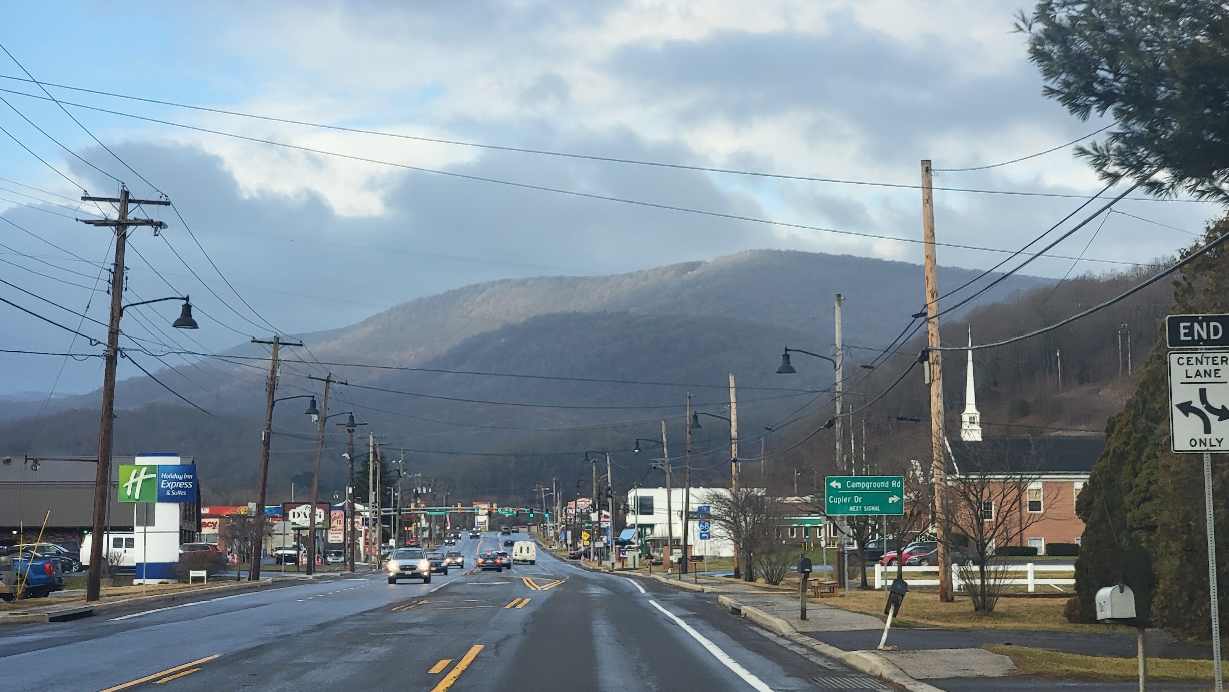
west of Bittinger evening

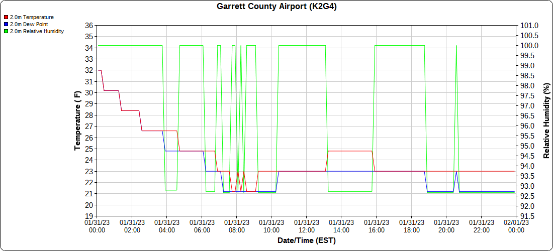
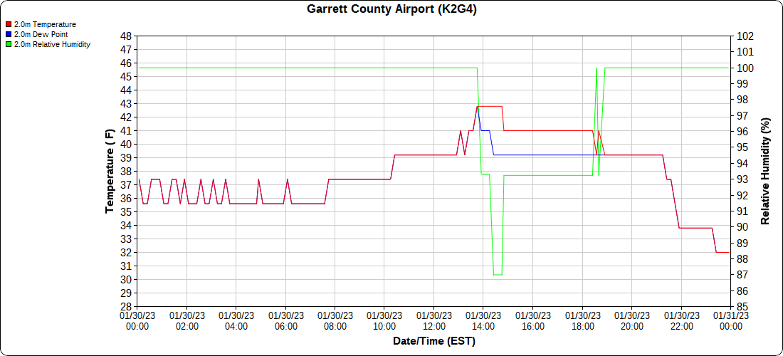
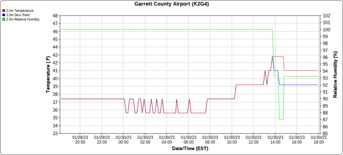
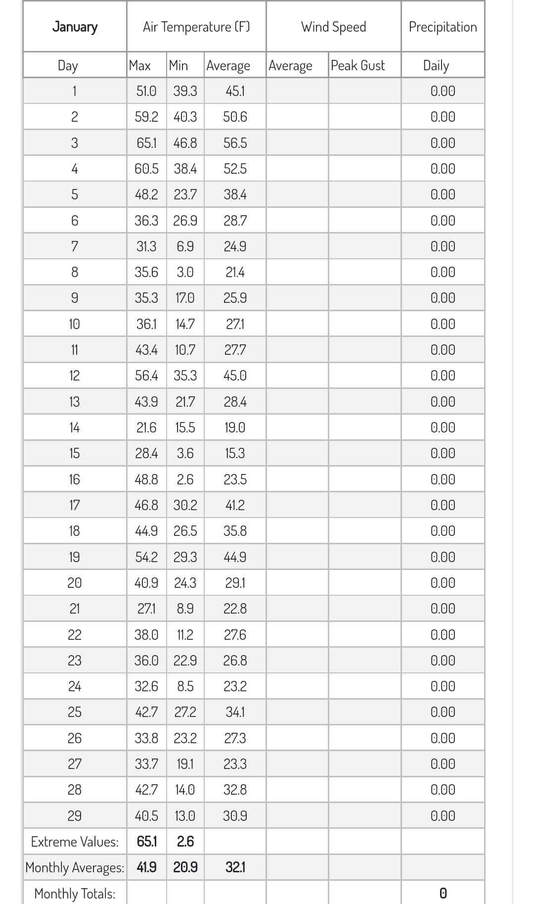
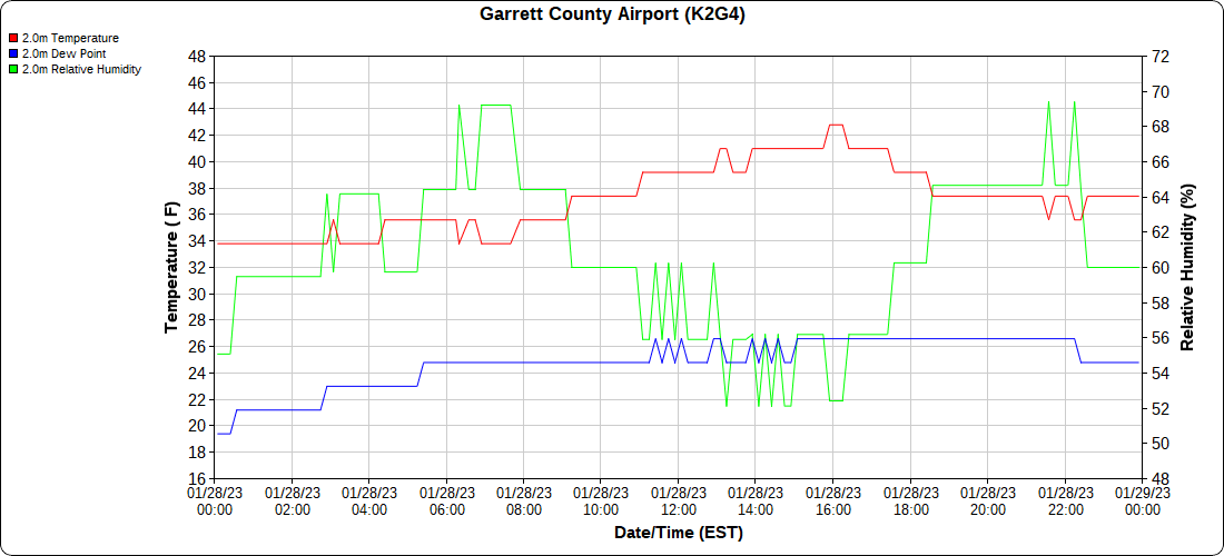
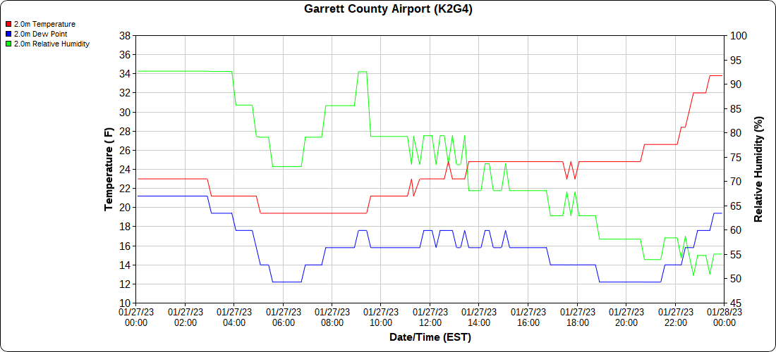
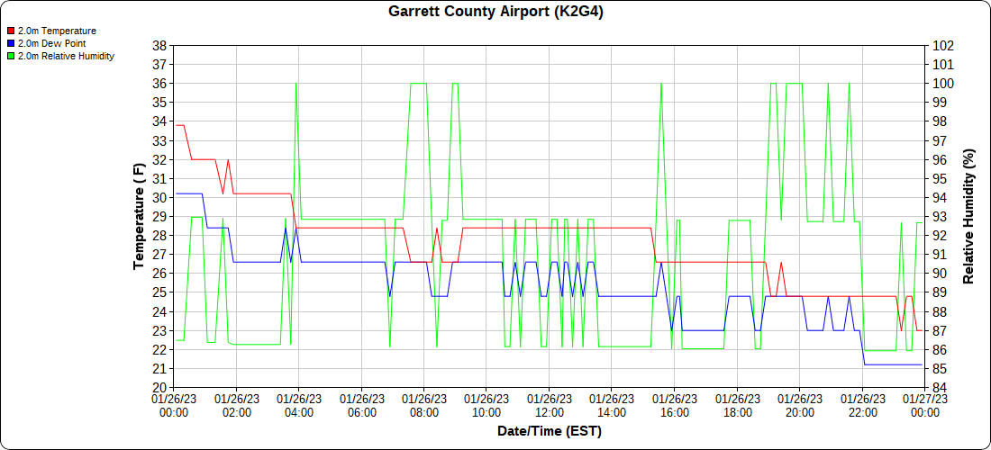
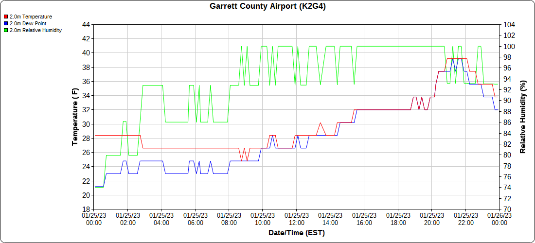
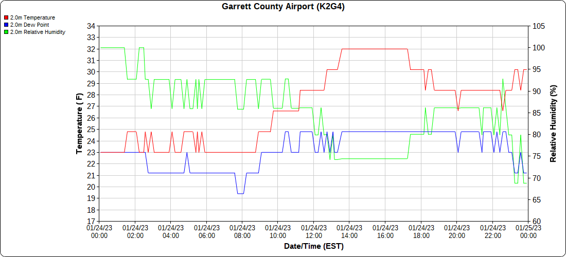
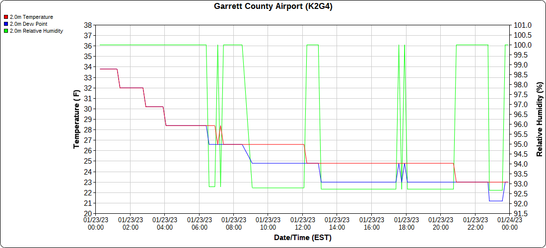
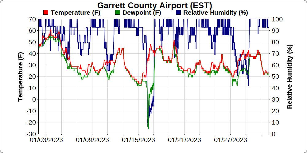
Garrett County Airport

monthly below

Cherry Creek Cove Deep Creek-morning

Top of Wisp

-rooftop station

Canaan Heights/Davis 3SE

7am to 7am data mmts coop

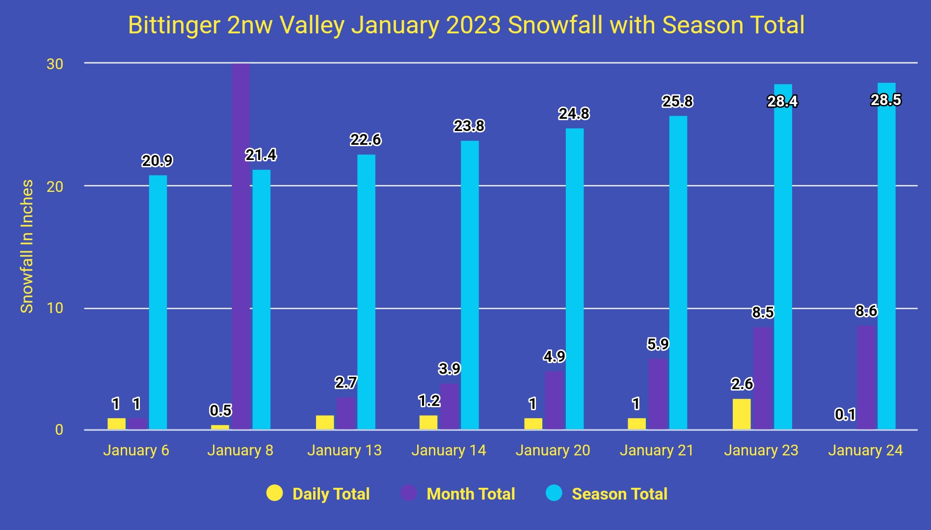
snowfall season to date:

midnight to midnight data Dyacon

Comments and data by Dave Lesher at:

http://data.canaanmtnsnow.com/

” Onset of light freezing drizzle overnight, changing to light snow before daybreak

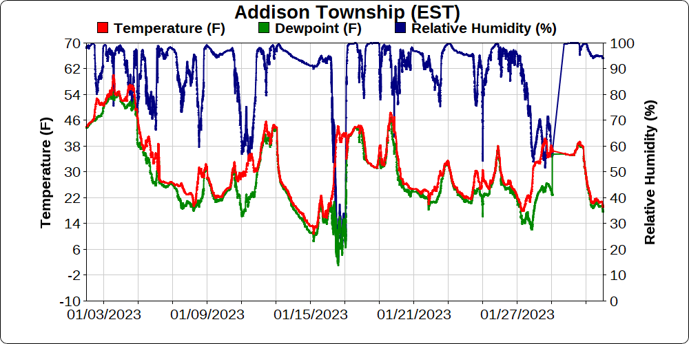
It was a January a great deal unlike January in Canaan normally is. It tied with January 2006 as the warmest January in the last 25 years here. See Table 10 below. That extent of the warmth kept the month’s total snowfall to just 18.4 inches, also #2 least snowiest January on record here, only slightly more than the 18.0 inches recorded in January 2013. See Tables 3.1 and 3.2 below”~Dave Lesher

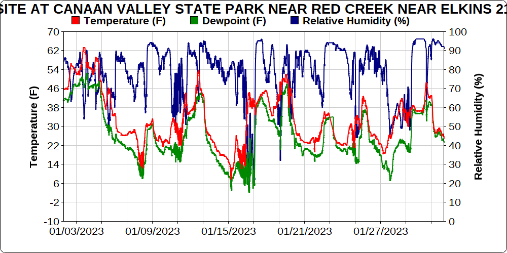
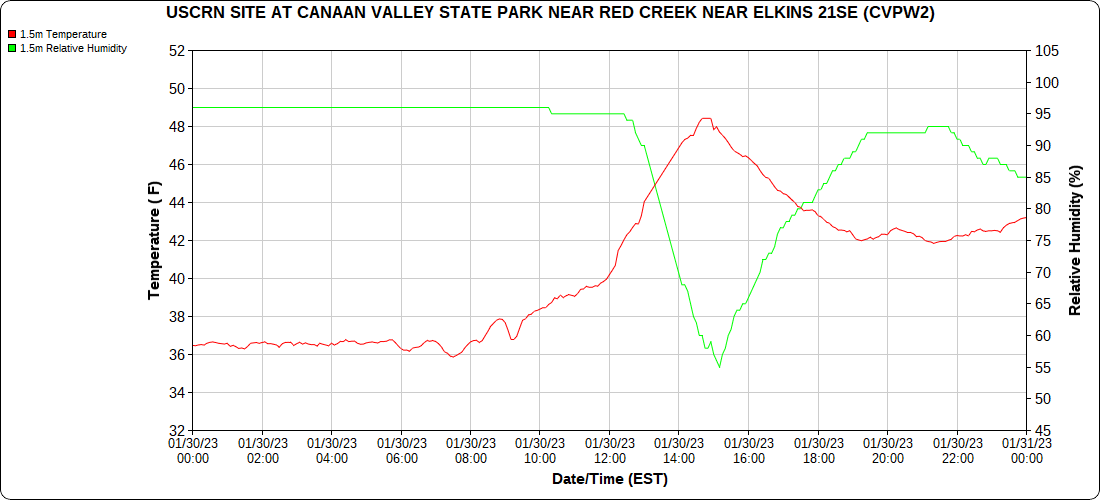
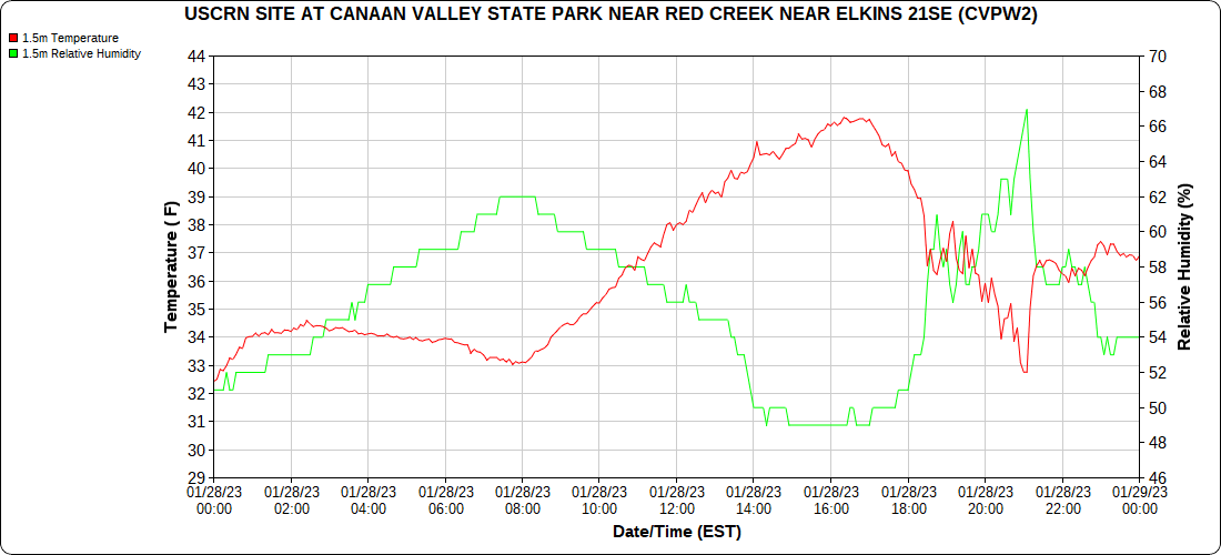
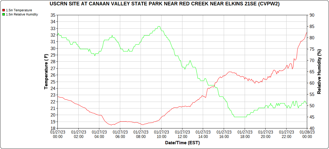
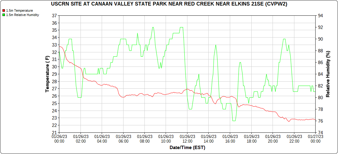
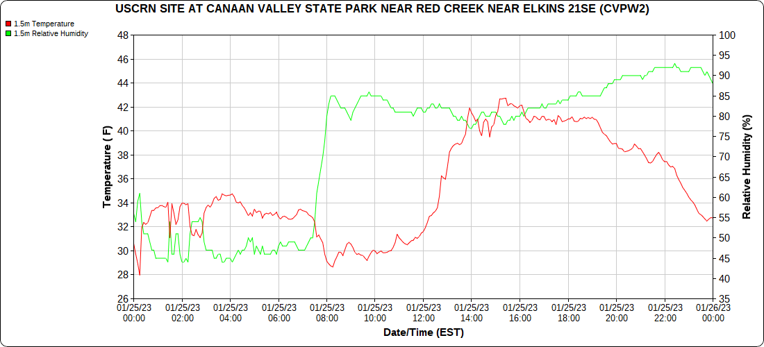
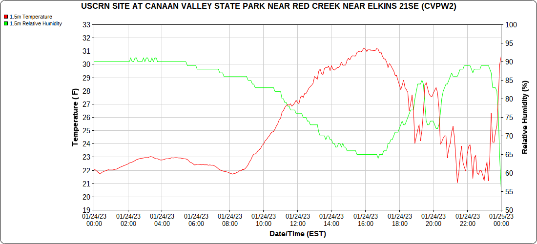
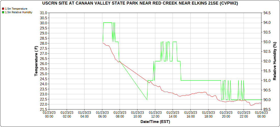
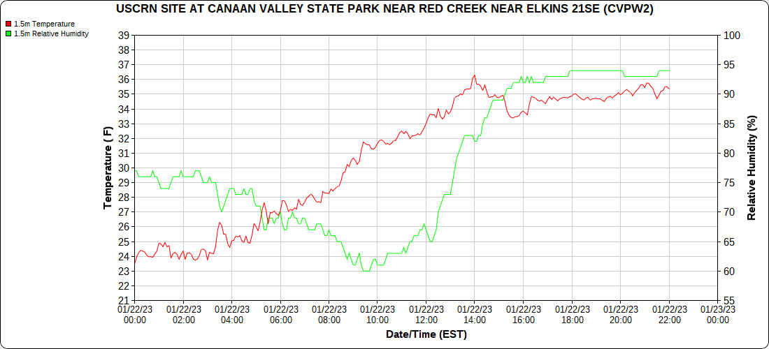
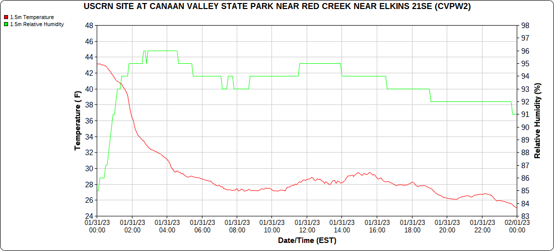
Climate Reference Network Canaan

the month below

Atop Canaan Ski area

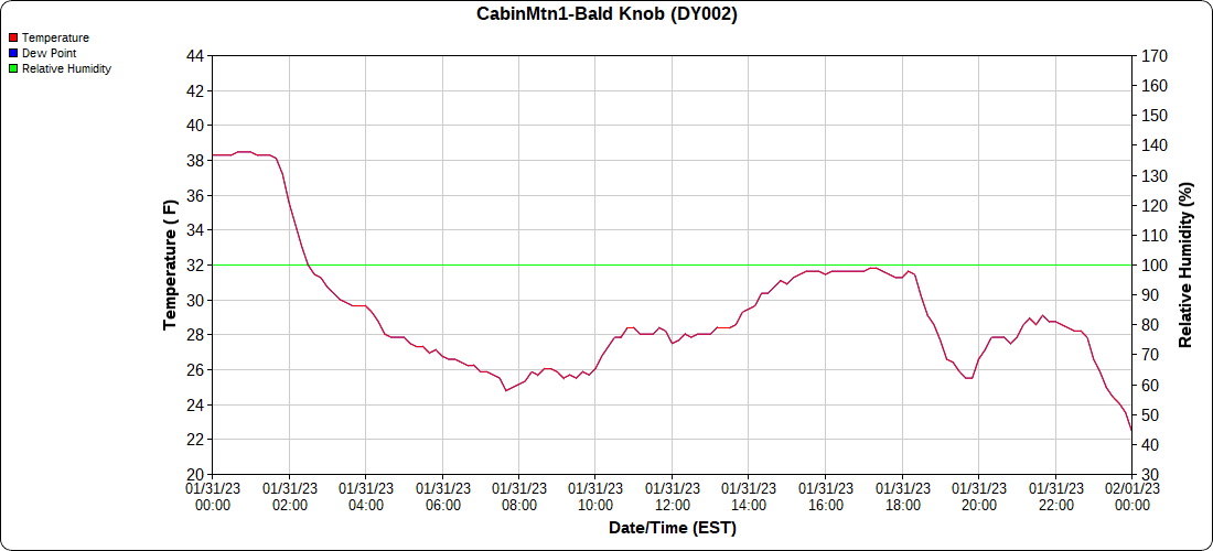
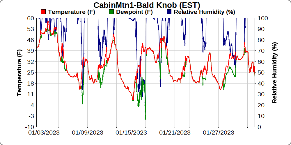
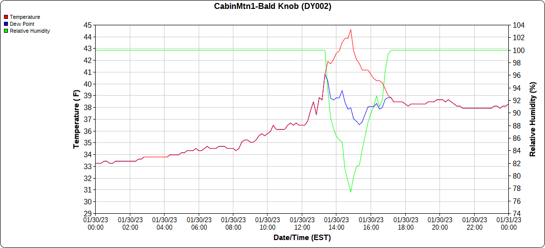
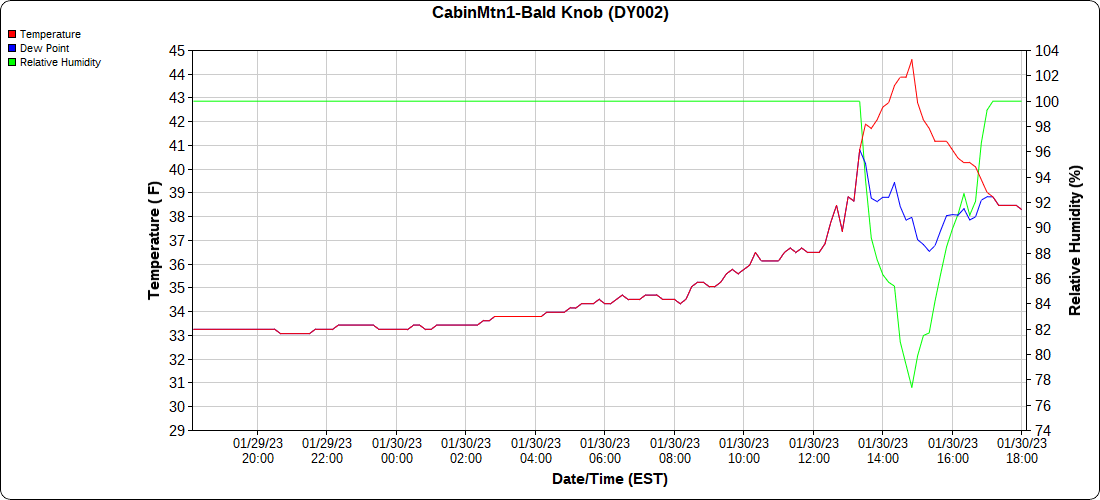
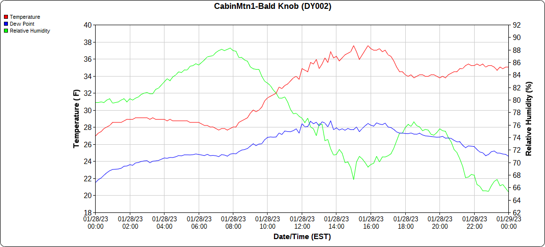
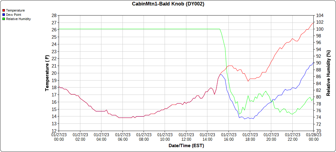
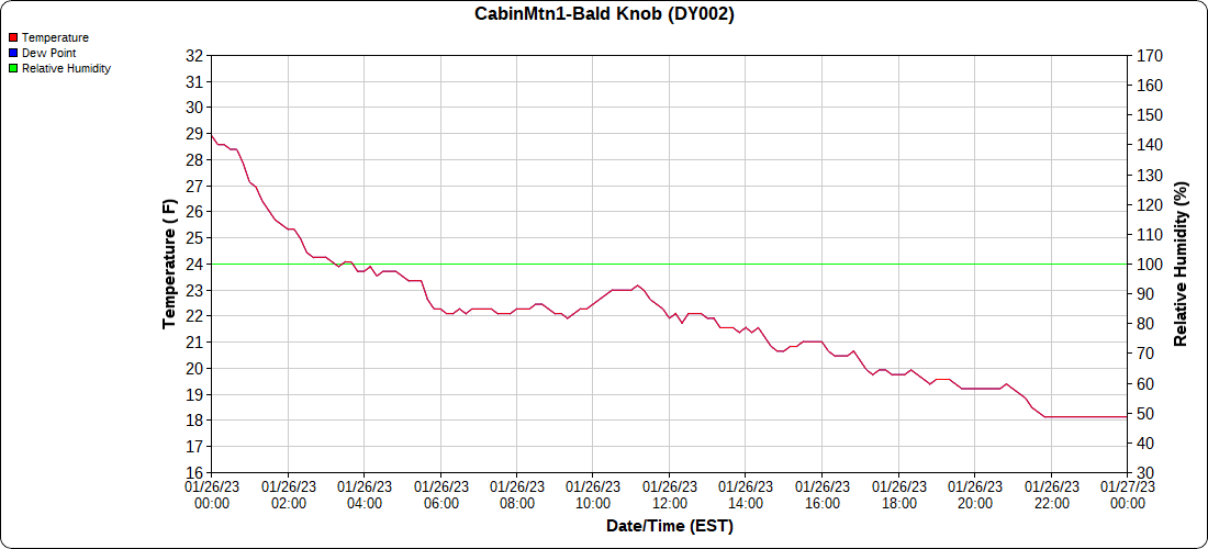
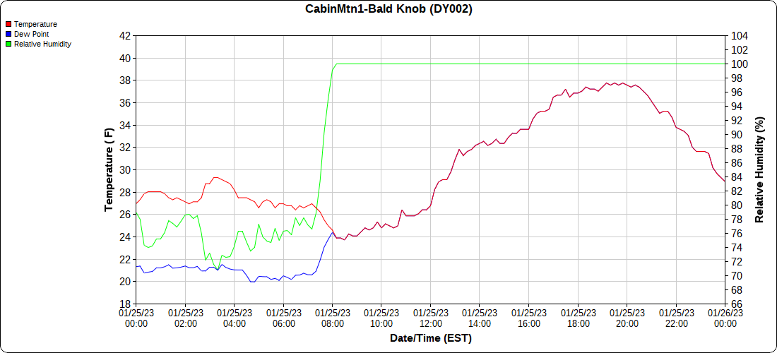
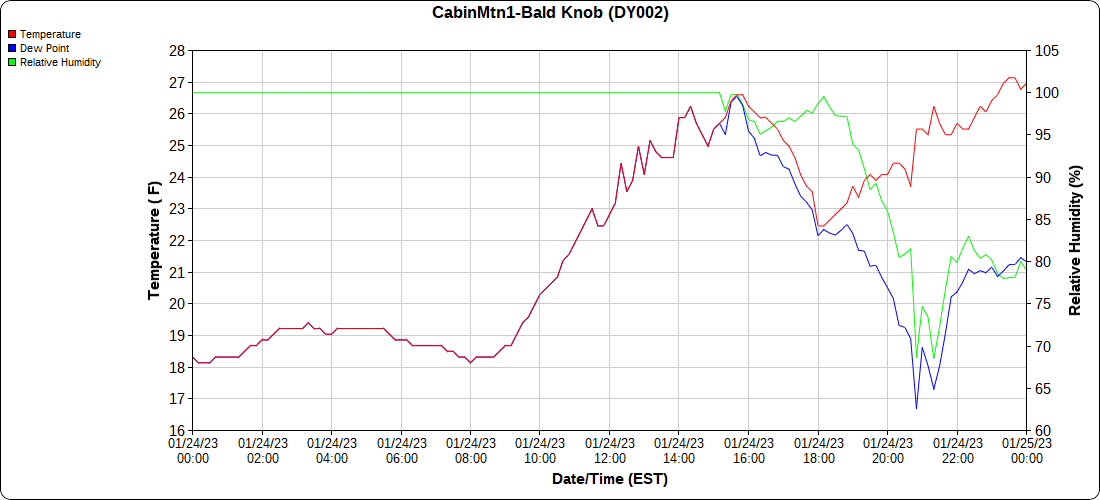
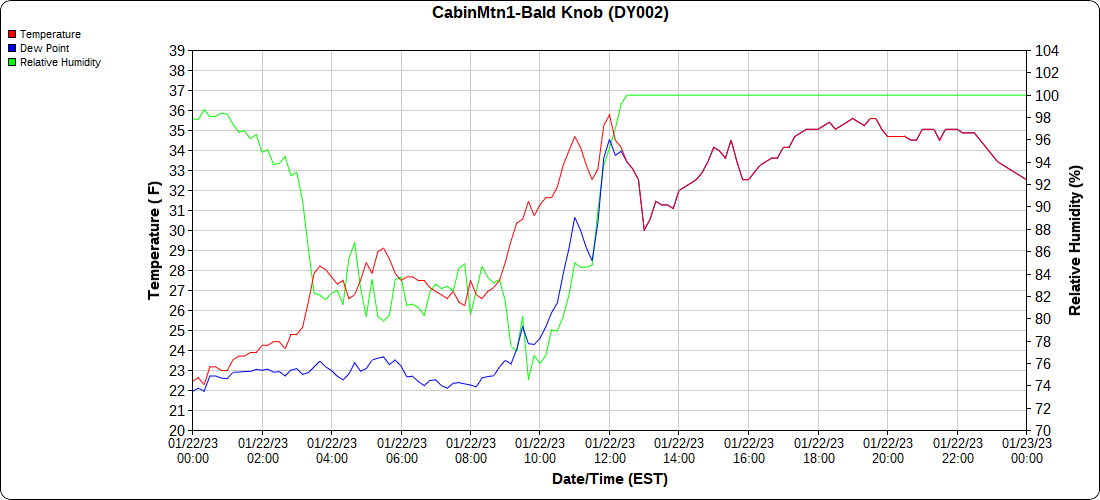
Cabin Mt at Bald Knob

the month below

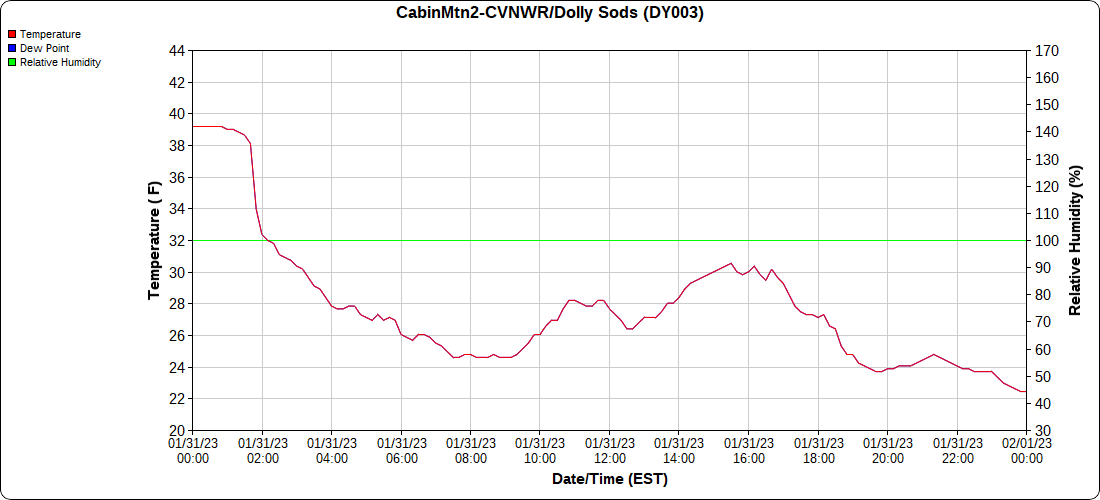
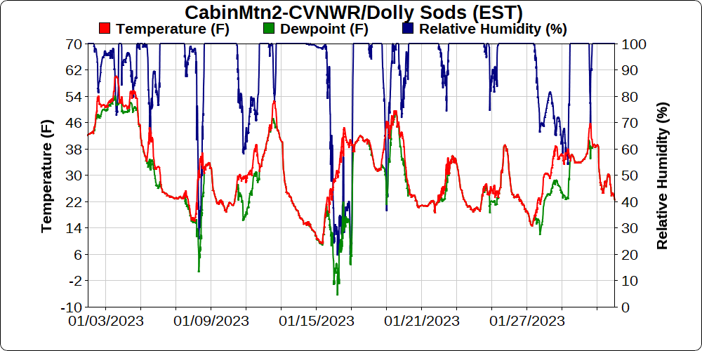
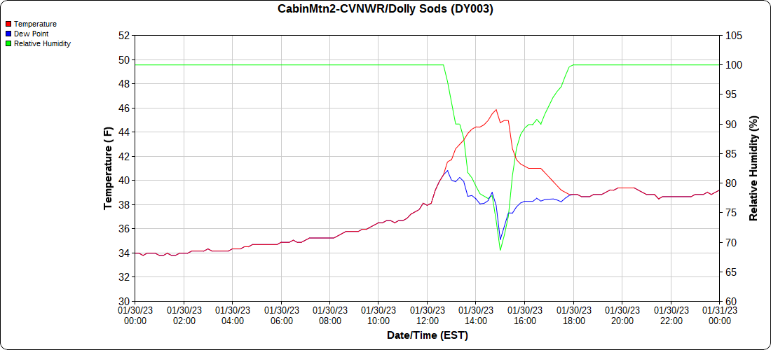
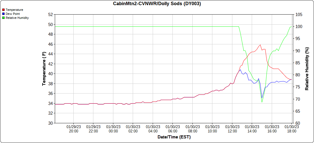
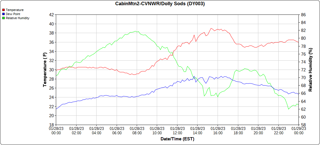
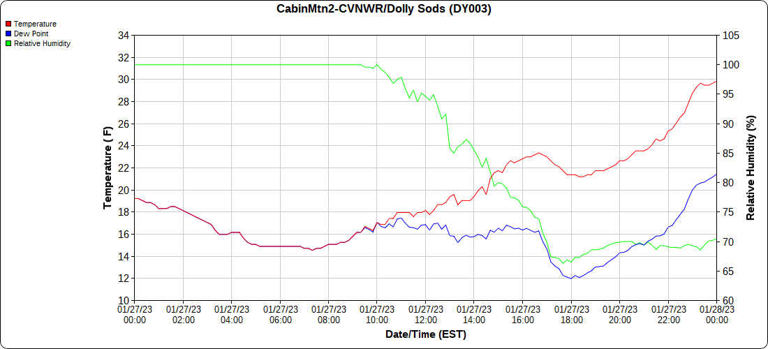
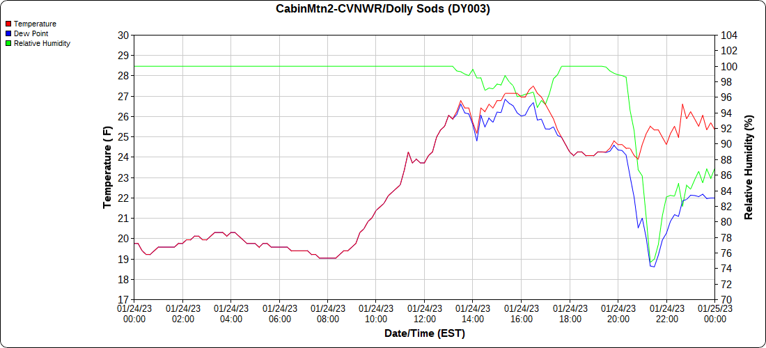
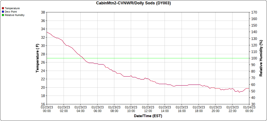
Cabin Mt-Western Sods

the month below

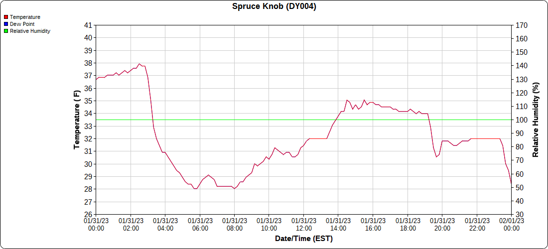
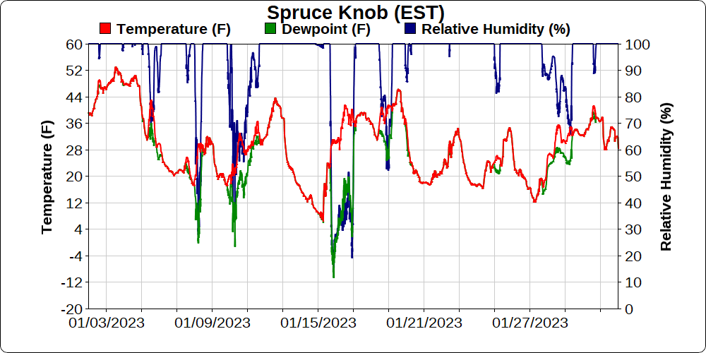
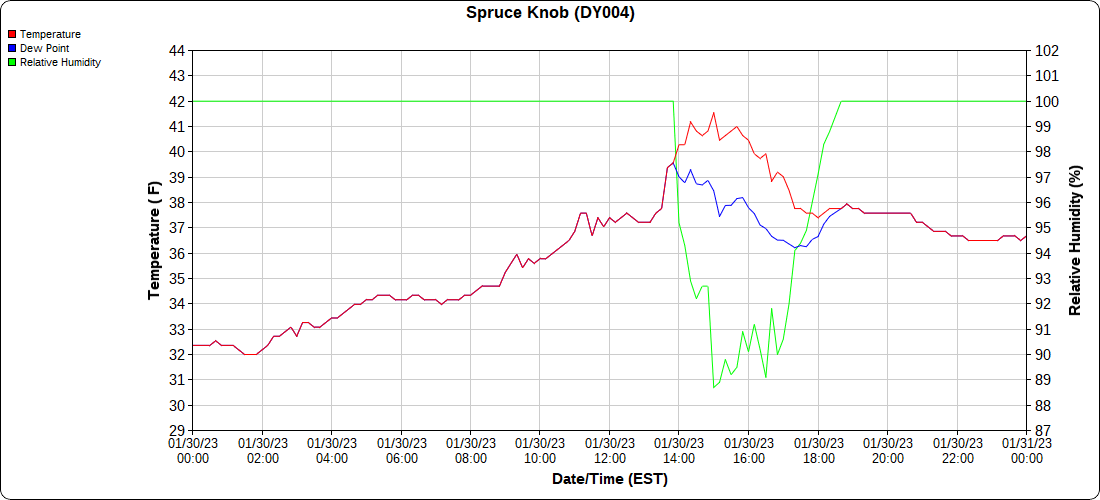
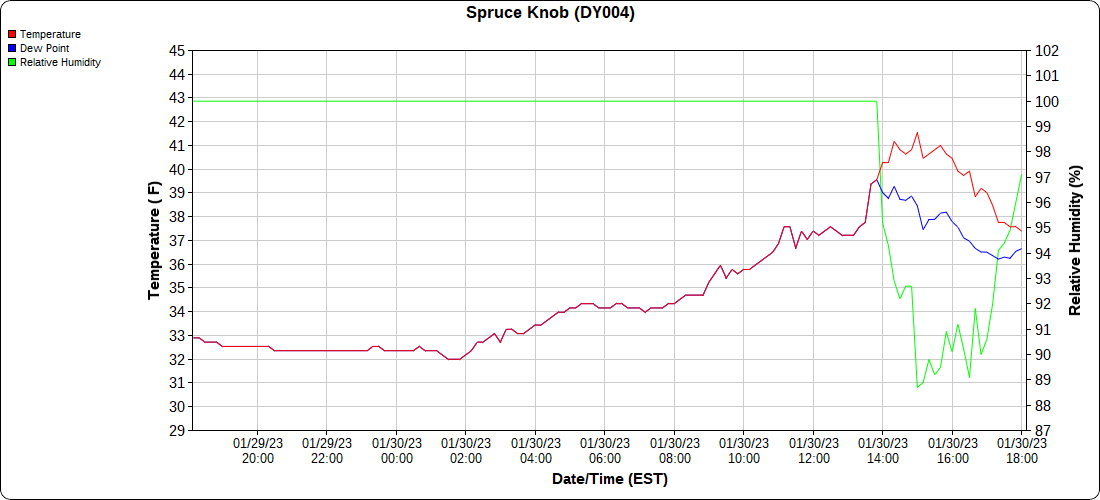
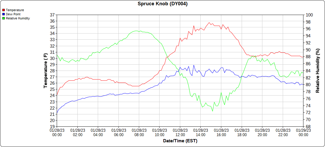
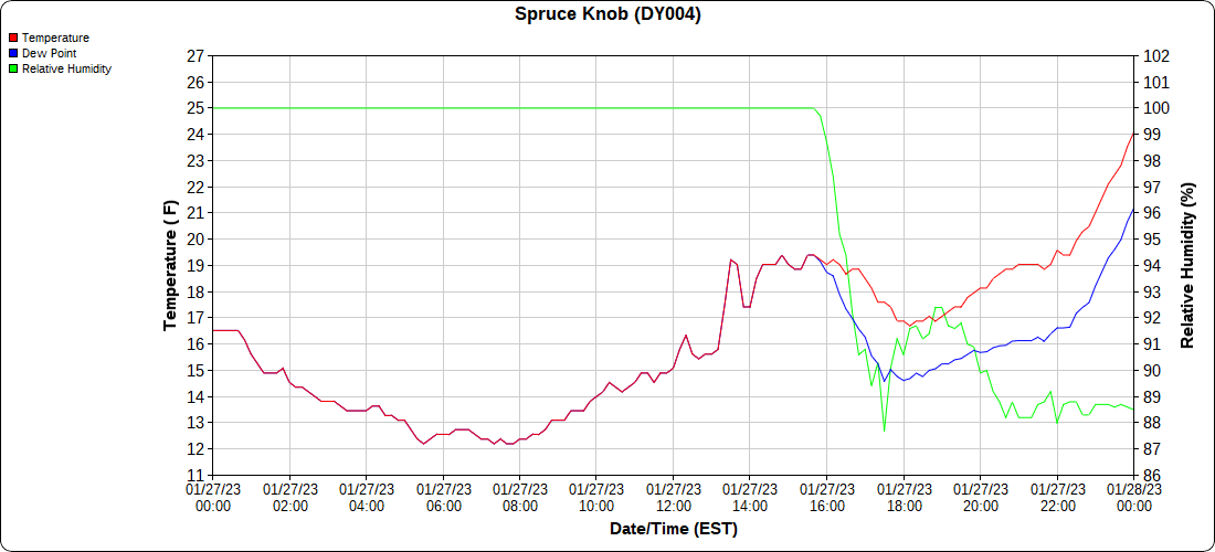
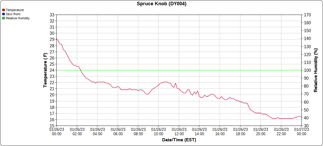
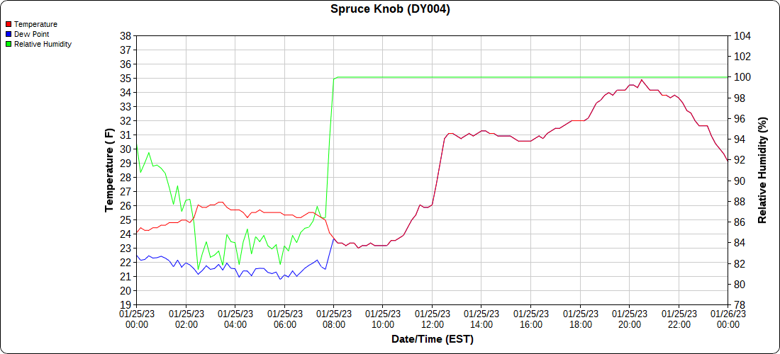
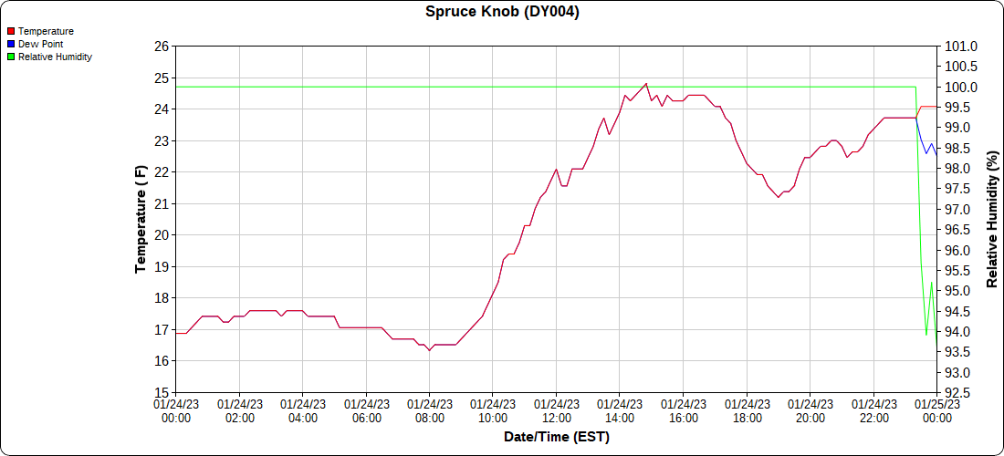
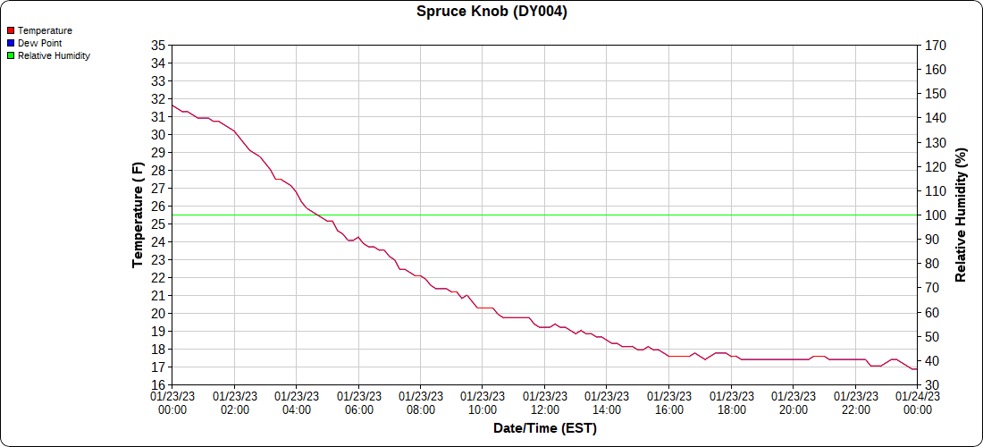
Spruce Knob

the month below

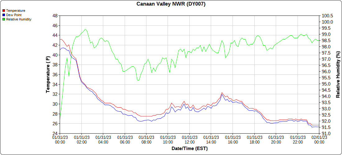
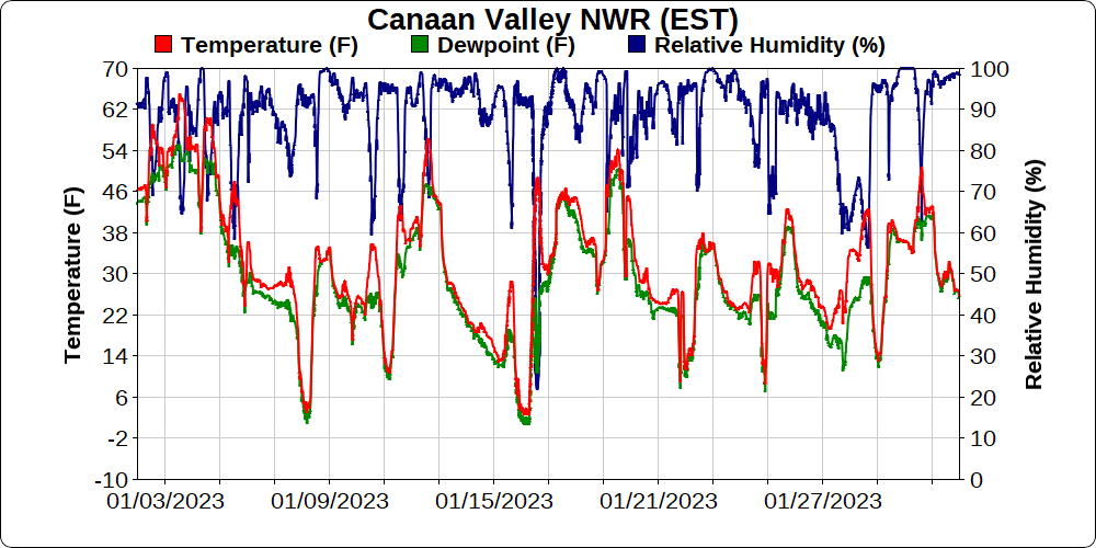
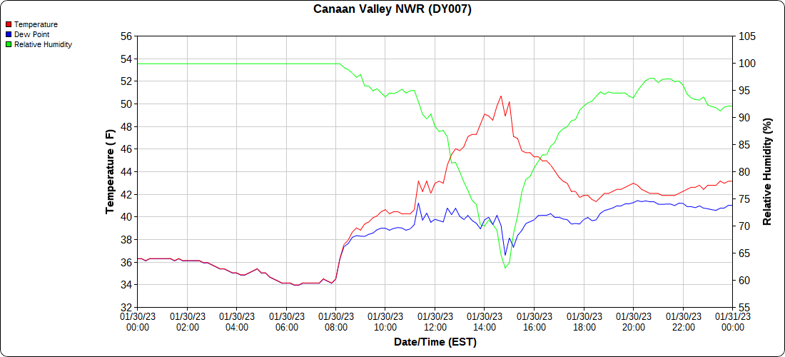
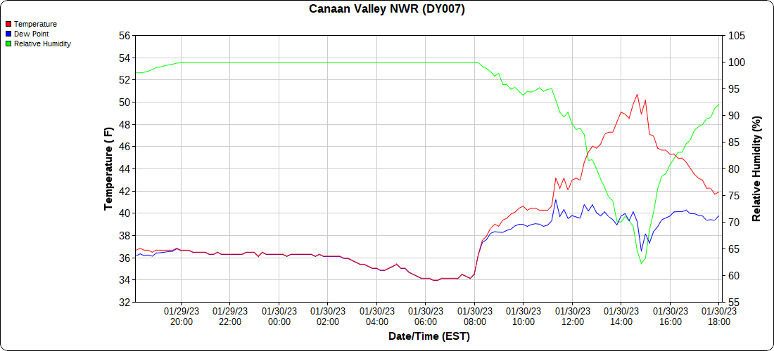
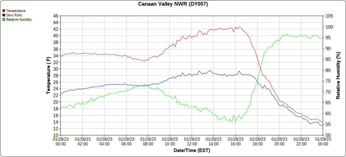
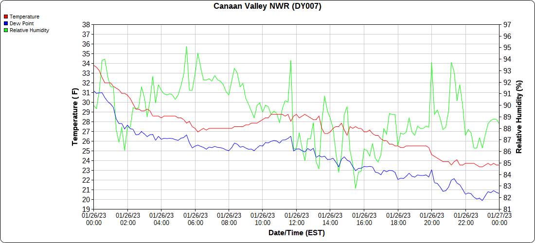
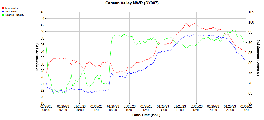
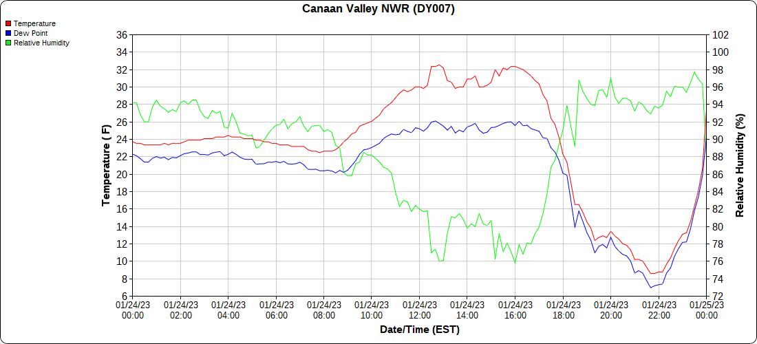
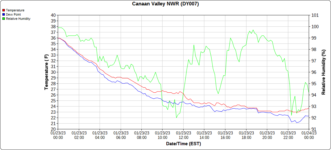
Canaan Valley Refuge

the month below

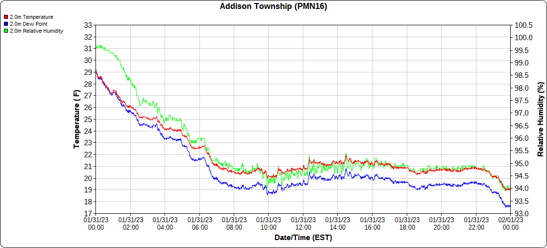
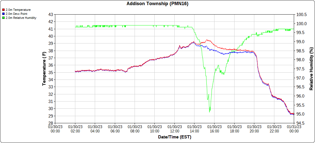
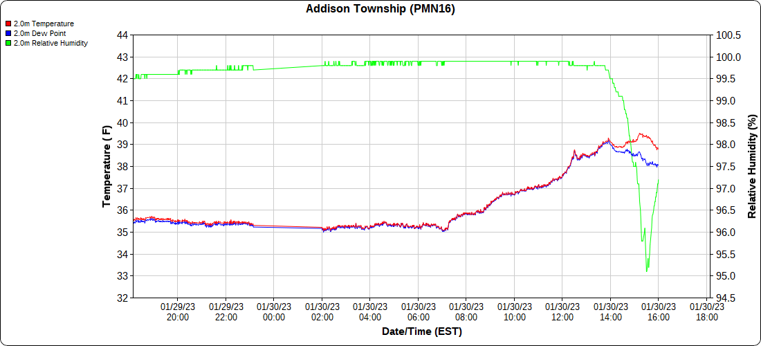
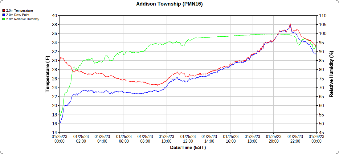
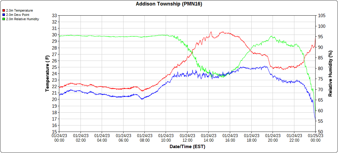
Mt.Davis

the month below

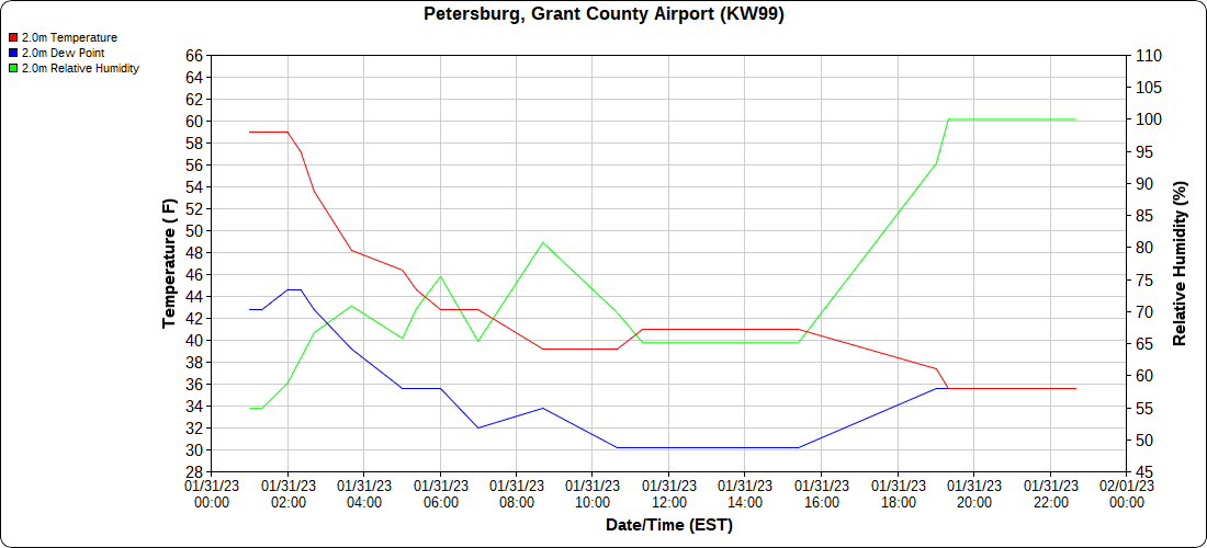
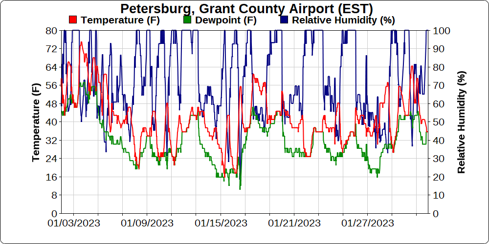
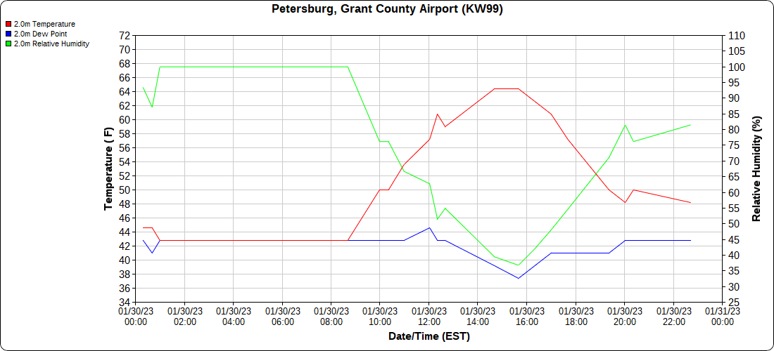
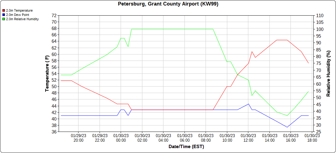
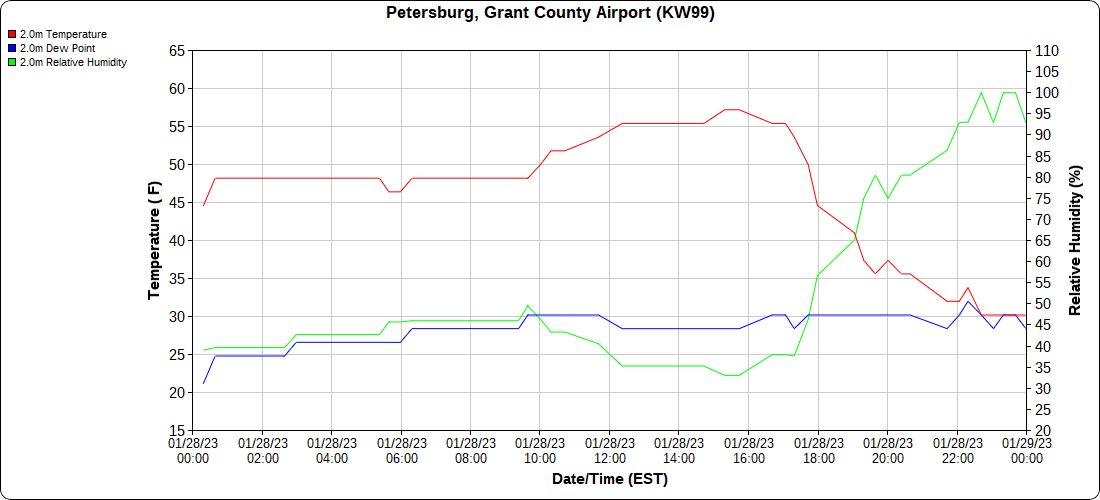
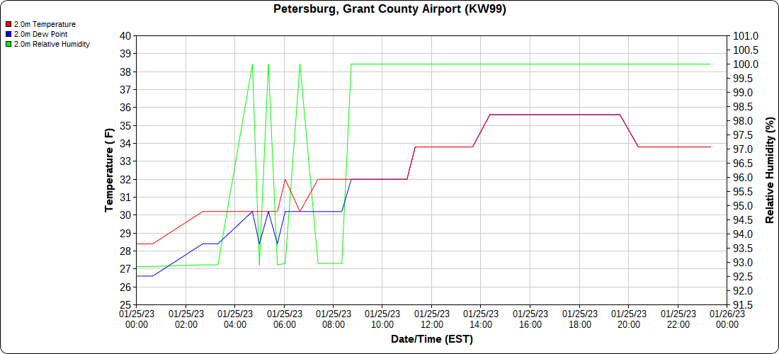
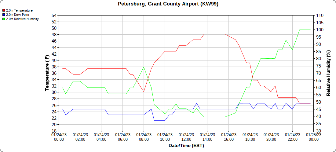
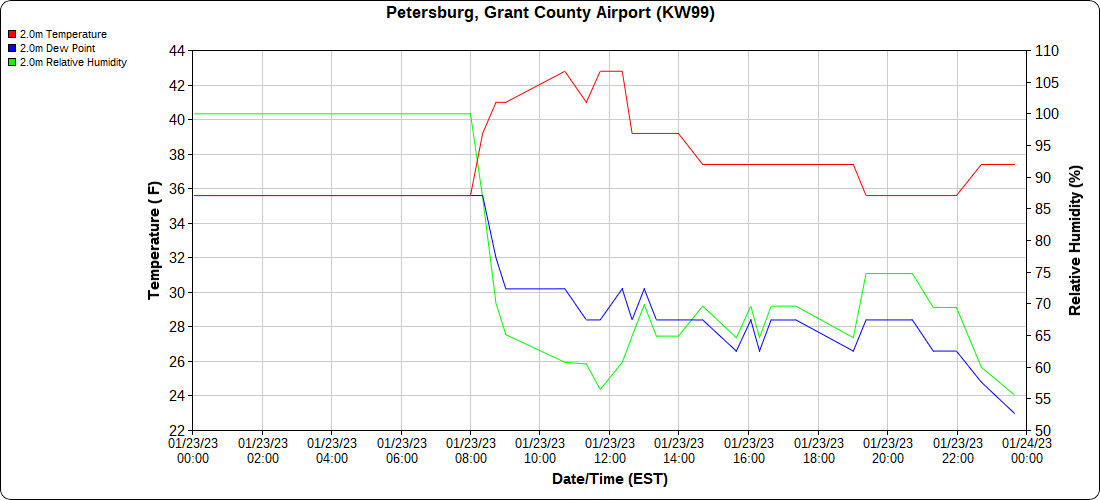
Petersburg Grant County Airport

the month below

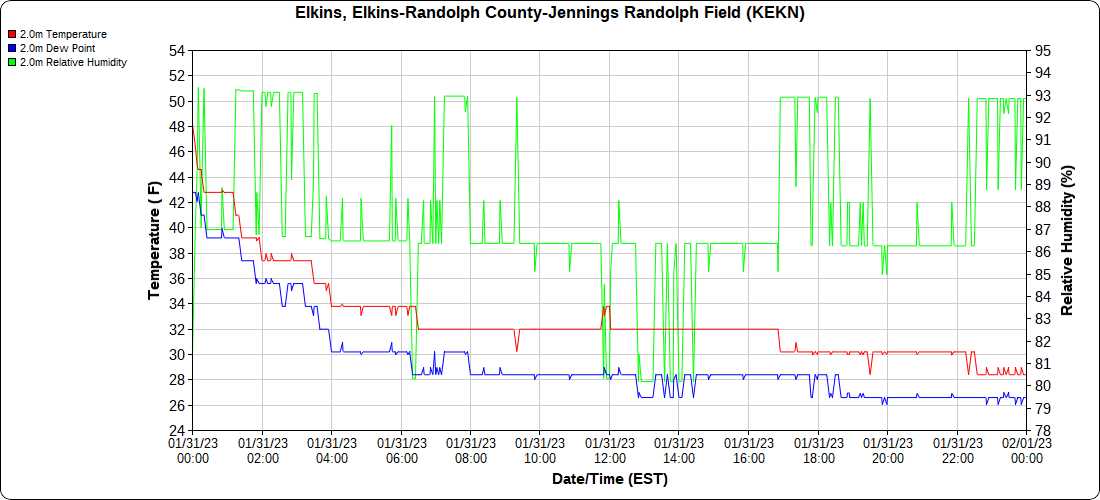
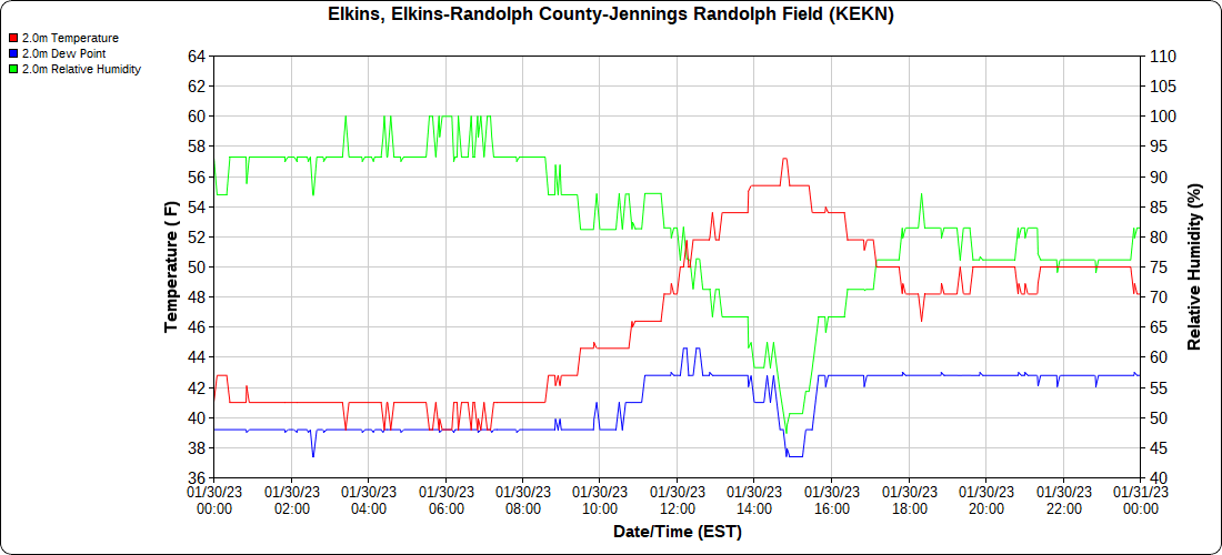
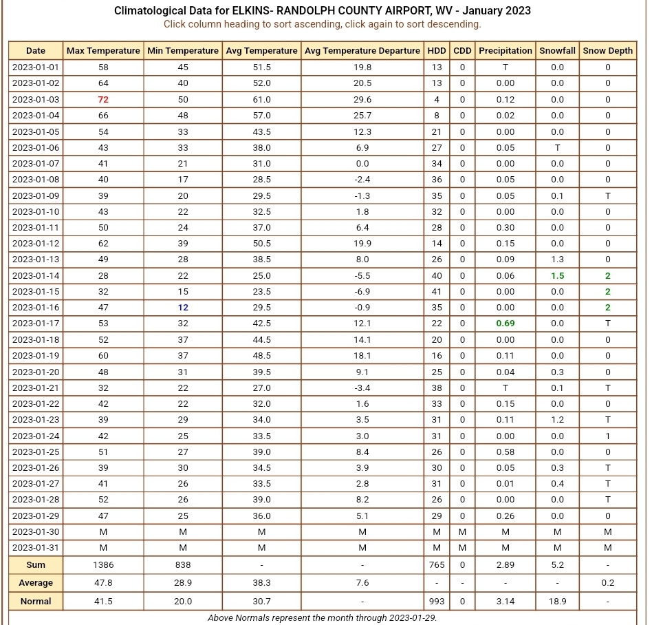
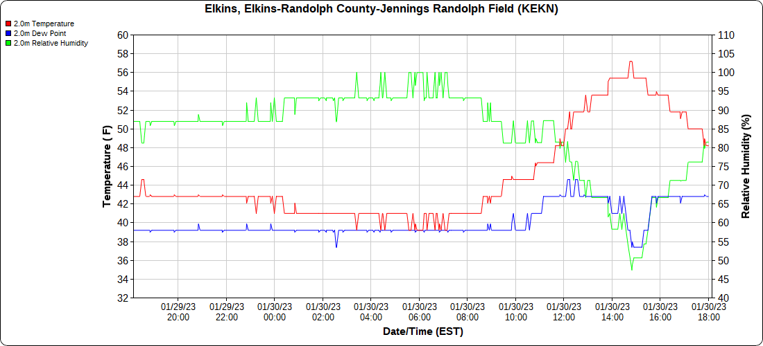
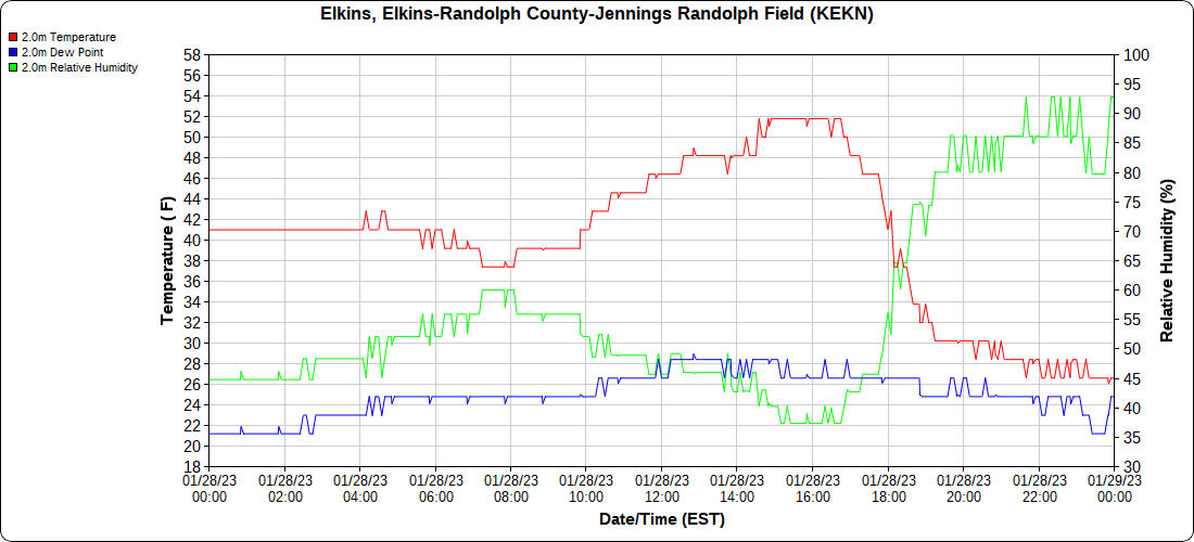
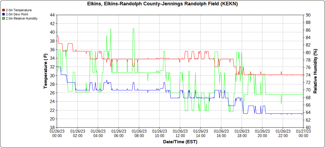
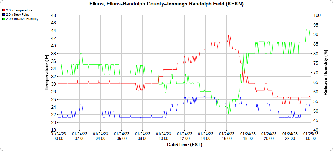
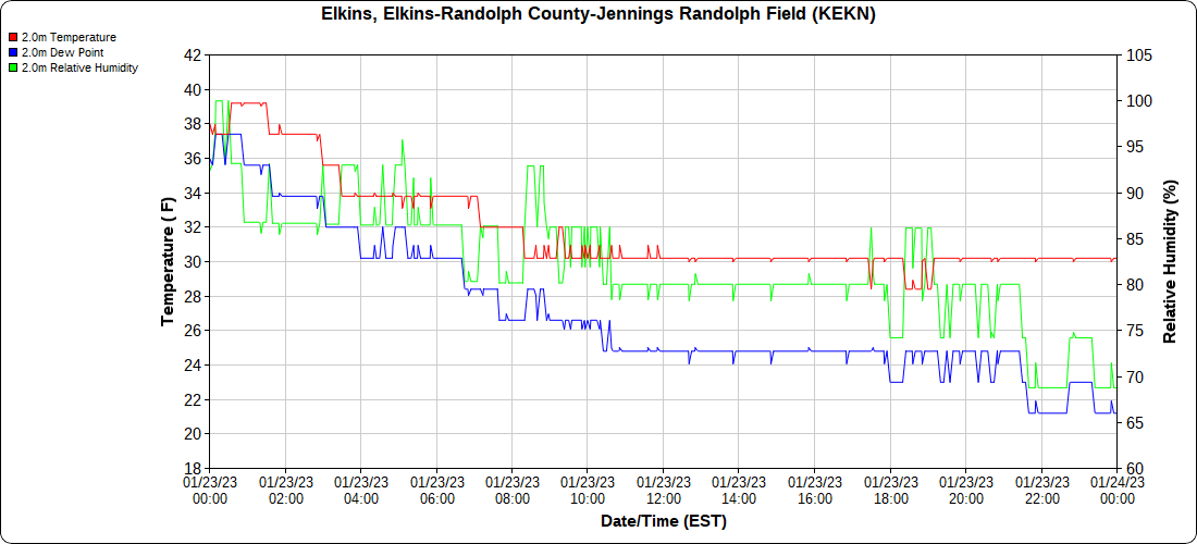
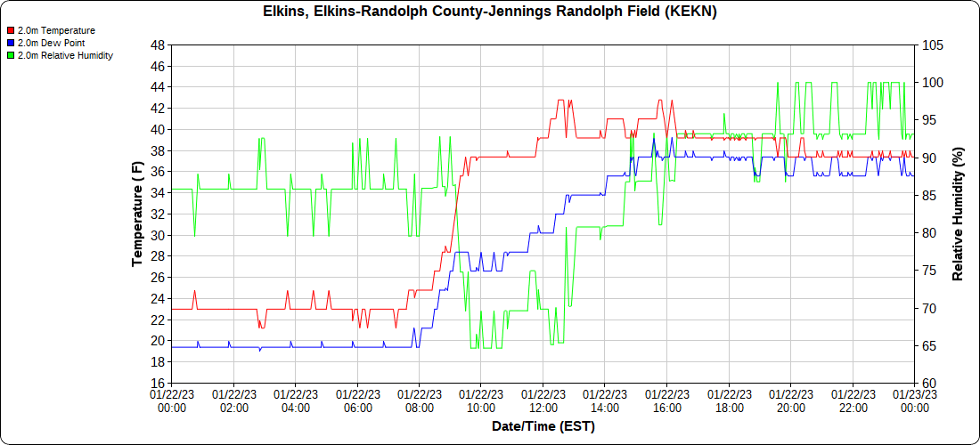
Elkins Airport

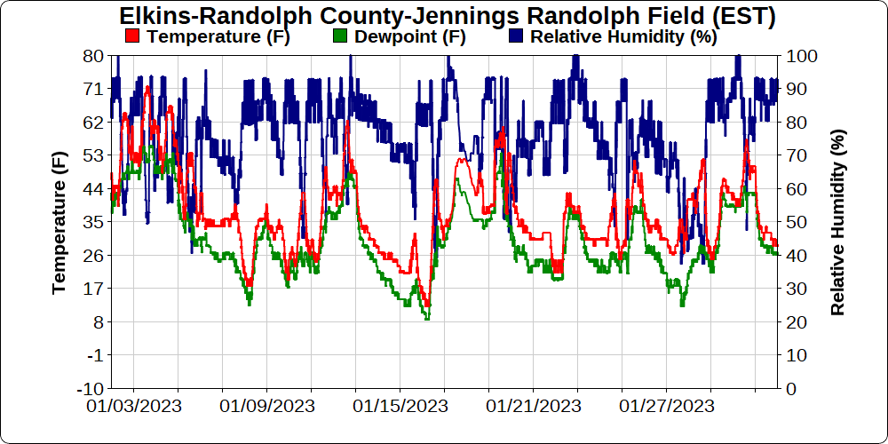
the month below

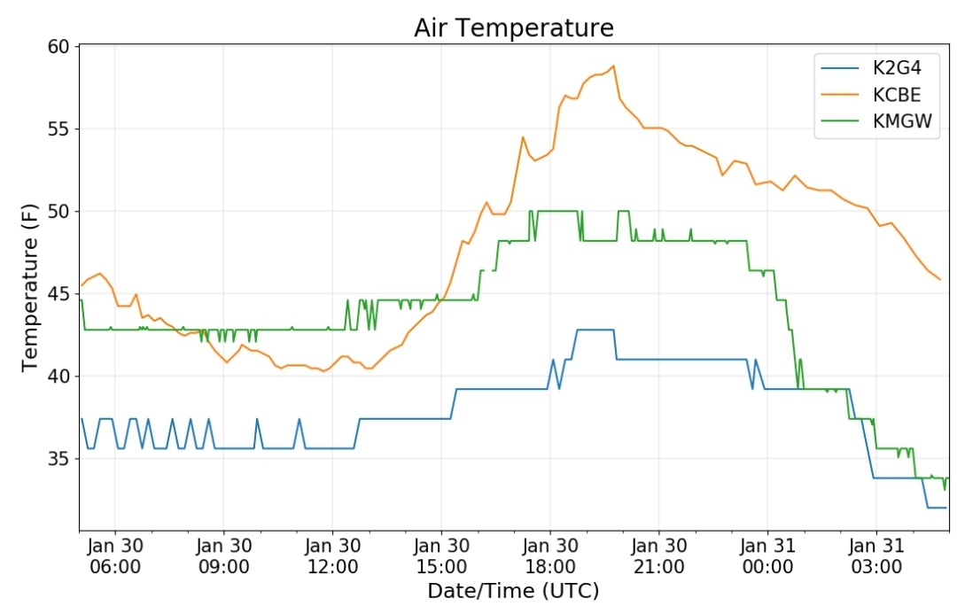
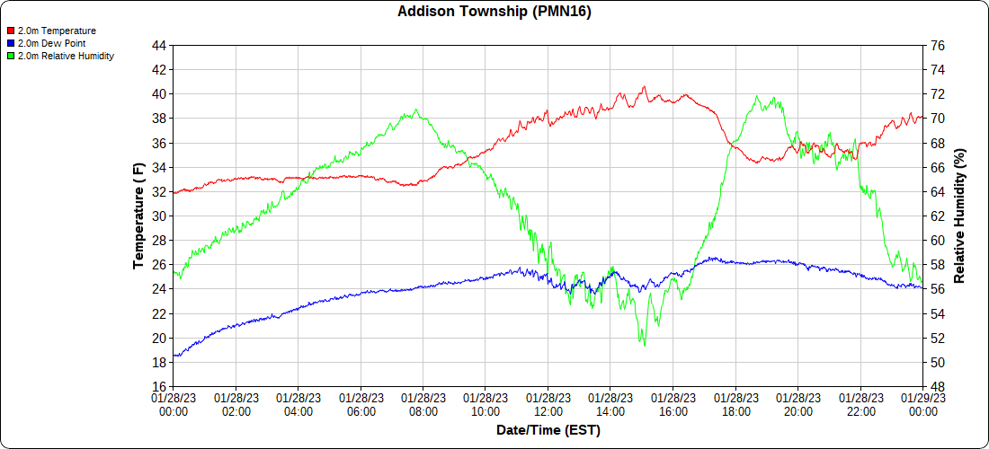
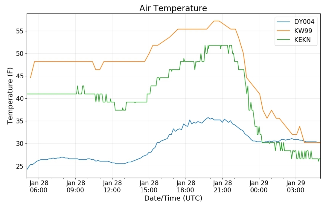
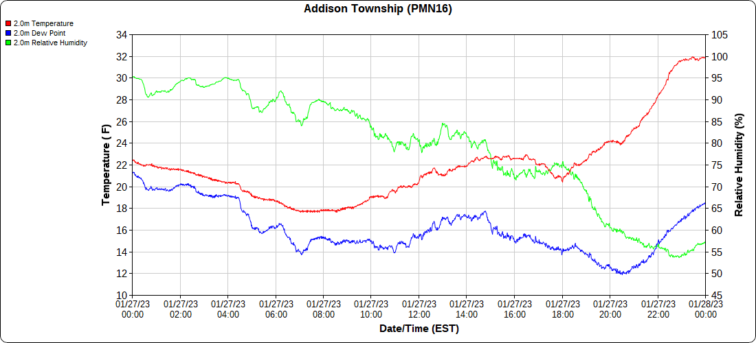
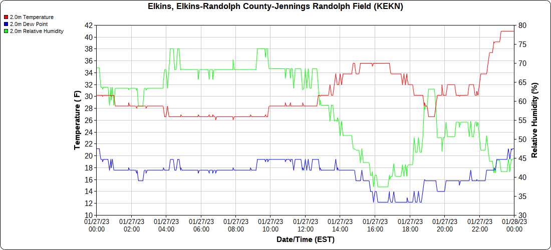
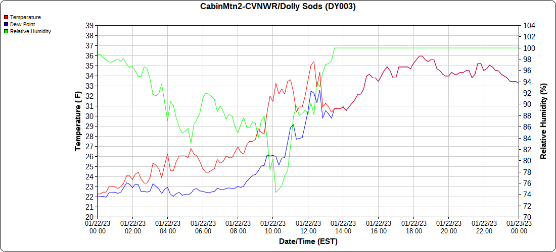
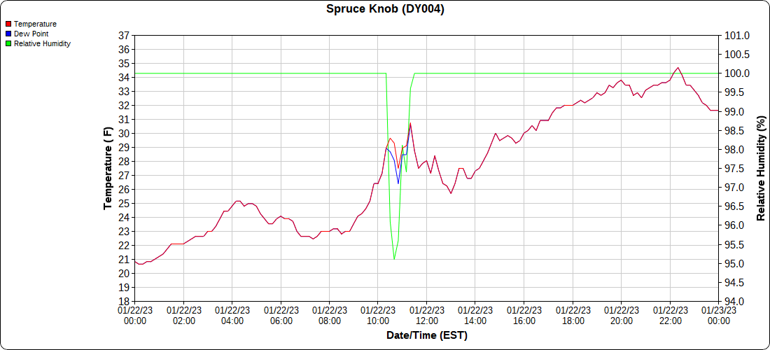
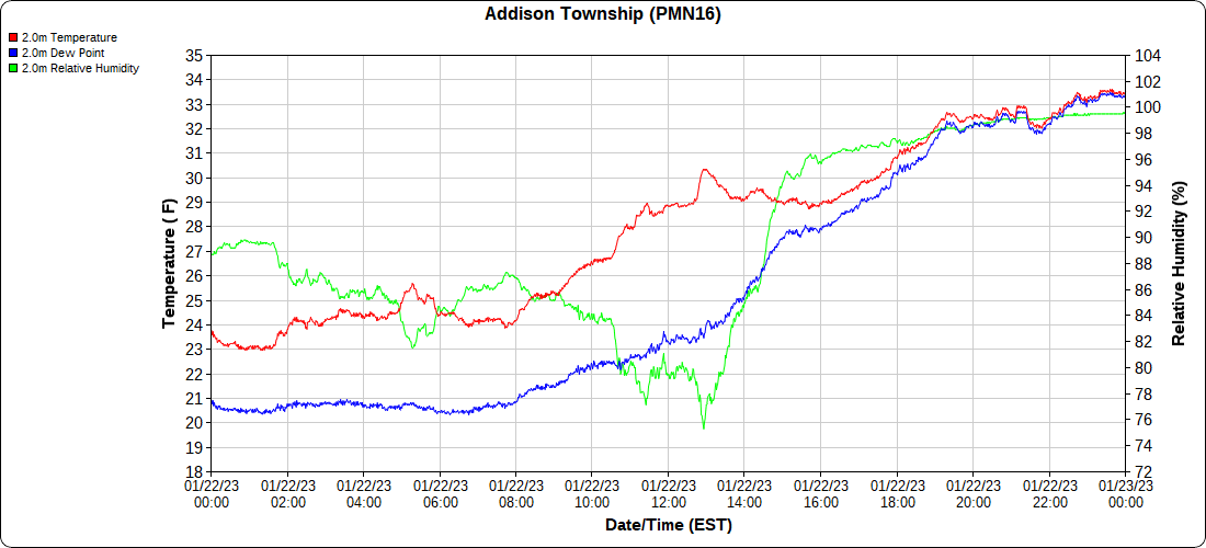
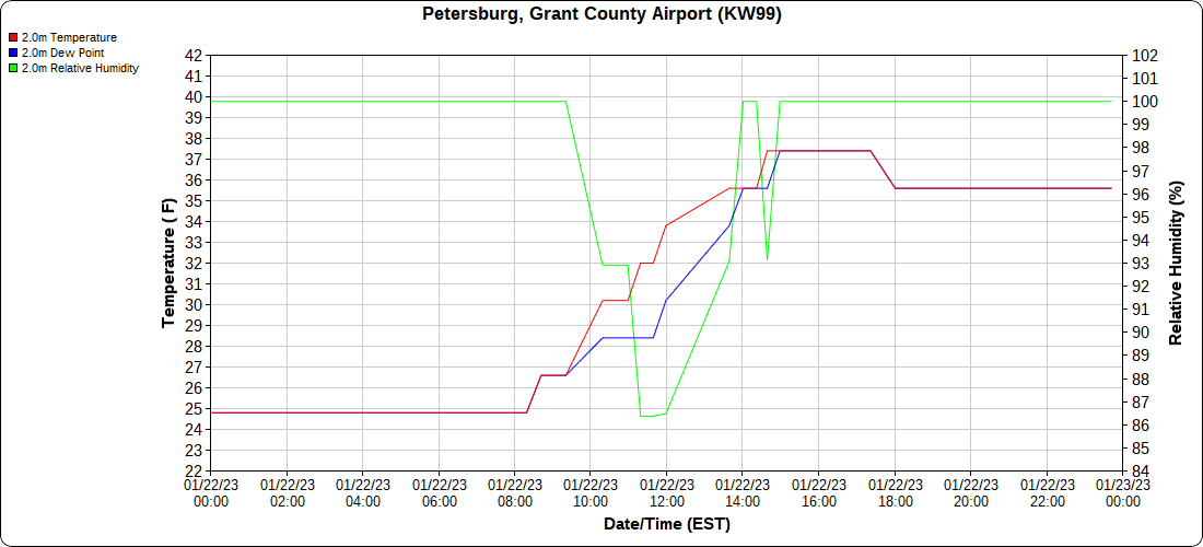
Dy007-Canaan Valley Refuge 3150′, Dy002-Cabin Mt at Bald Knob 4350′, Dy003-Cabin Mt-Western Sods 4035′, Dy004-Spruce Knob 4820′, Cvpw2-Climate Reference Network Canaan 3380′, KW99-Petersburg Grant County Airport 961, K2G4 Garrett County Airport 2933′, KCBE Cumberland Airport 774′, KEKN Elkins Airport 1985′, KMGW Morgantown Airport 1227′, PMN16-Mt.Davis 3038′, KDCA-Reagan National 15′, G1472 Snowshoe 4500′

  • Daily Comparison And The Month Comparison

The Valley vs Cabin Mt

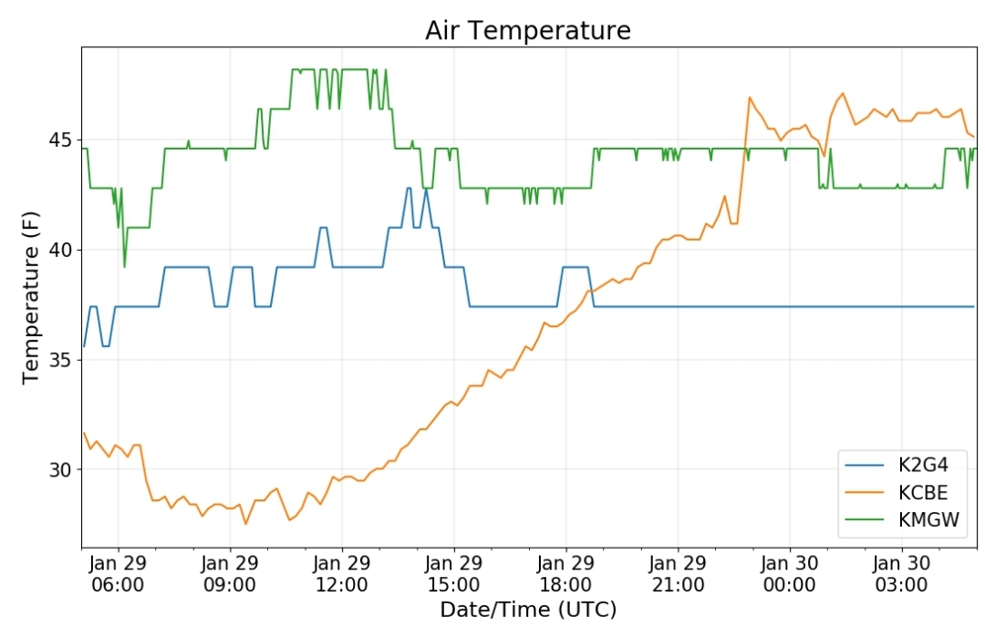
Canaan area temps

High Ground Comparison

(cold air slow to work south over the high ground on the 31st

Up High and Down Low

Up High, High Valley, Low Valley

The Valleys

WV High Ground Cold spots vs DCA

RTMA

monthly RTMA

Radar

Satellite

Flow

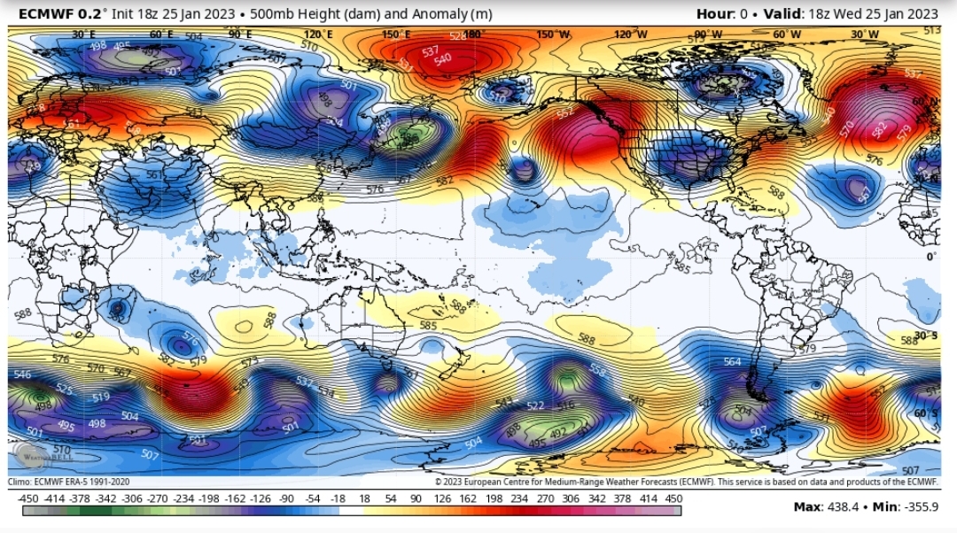
Surface Features and 500mb Height anomalies and Flow

Webcams today-

west was best for light snow today

January 2023

January 2023 Temps

Prism Data

January 2023 Precip

observed:

departure:

-some area coops with 7am obs(Canaan Valley 2 9am)

in PA

MD

WV

long running station at Bayard

overall this is the 18th mildest January

Let’s look at those warmest ones
So while this year was a bad January for winters lovers, much worse has existed. You have to go back a ways.
January 30, 2023
January 30, 2023

Forest Service Cam offline since 6/24/21

Jan 30(Mon)

Cloudy, some fog, some drizzle more sun south and west.

Bittinger 2nw Valley

towards Bowman Hill morning
Bittinger 2nw Valley morning
Foxtown Rd morning
Bittinger 2nw Valley afternoon
Bittinger 2nw Valley afternoon 🤣
Bittinger 2nw Valley afternoon

Garrett County Airport

Cherry Creek Cove morning
Deep Creek morning
Deep Creek midday

Top of Wisp

Canaan Heights/Davis 3SE

7am to 7am data mmts coop
Midnight to midnight data Dyacon

Comments and data by Dave Lesher at:

http://data.canaanmtnsnow.com/

Climate Reference Network Canaan

Atop Canaan Ski area

Cabin Mt at Bald Knob

Cabin Mt-Western Sods

Spruce Knob

Canaan Valley Refuge

Mt.Davis

Petersburg Grant County Airport

Elkins Airport

Dy007-Canaan Valley Refuge 3150′, Dy002-Cabin Mt at Bald Knob 4350′, Dy003-Cabin Mt-Western Sods 4035′, Dy004-Spruce Knob 4820′, Cvpw2-Climate Reference Network Canaan 3380′, KW99-Petersburg Grant County Airport 961, K2G4 Garrett County Airport 2933′, KCBE Cumberland Airport 774′, KEKN Elkins Airport 1985′, KMGW Morgantown Airport 1227′, PMN16-Mt.Davis 3038′, KDCA-Reagan National 15′, G1472 Snowshoe 4500′

The Valley vs Cabin Mt

Canaan area temps

High Ground Comparison

Up High and Down Low

Up High, High Valley, Low Valley

The Valleys

WV High Ground Cold spots vs DCA

RTMA

Radar

Satellite

Flow

Surface Features and 500mb Height anomalies and Flow

Sideling Hill Creek at Northcraft

Town Hill

Polish Mt

Martin’s Mt

Savage Mt to Amish Rd

Cranesville area

over the Mt

Kings Run Rd

January 29, 2023

January 29, 2023

Forest Service Cam offline since 6/24/21

Jan 29(Sun)

Cold last night in the Valleys, incoming clouds and some rain with a little high elevation snow above 4000′ no accumulation

Bittinger 2nw Valley

Bittinger 2nw Valley morning

Garrett County Airport

Top of Wisp

Canaan Heights/Davis 3SE

7am to 7am data mmts coop
midnight to midnight data Dyacon

Comments and data by Dave Lesher at:

http://data.canaanmtnsnow.com/

pic by Dave Lesher

Climate Reference Network Canaan

Atop Canaan Ski area

Cabin Mt at Bald Knob

Cabin Mt-Western Sods

Spruce Knob

Canaan Valley Refuge

Mt.Davis

Petersburg Grant County Airport

Elkins Airport

Dy007-Canaan Valley Refuge 3150′, Dy002-Cabin Mt at Bald Knob 4350′, Dy003-Cabin Mt-Western Sods 4035′, Dy004-Spruce Knob 4820′, Cvpw2-Climate Reference Network Canaan 3380′, KW99-Petersburg Grant County Airport 961, K2G4 Garrett County Airport 2933′, KCBE Cumberland Airport 774′, KEKN Elkins Airport 1985′, KMGW Morgantown Airport 1227′, PMN16-Mt.Davis 3038′, KDCA-Reagan National 15′, G1472 Snowshoe 4500′

The Valley vs Cabin Mt

Canaan area temps

High Ground Comparison

Up High and Down Low

Up High, High Valley, Low Valley

The Valleys

WV High Ground Cold spots vs DCA

RTMA

Radar

Satellite

Flow

Surface Features and 500mb Height anomalies and Flow

33 East of Harman at the Divide

Snowshoe

Canaan

January 28, 2023

January 28, 2023

Forest Service Cam offline since 6/24/21

Jan 28(Sat)

Clouds, sun, breezy
Bittinger 2nw Valley

Bittinger 2nw Valley morning
Bittinger 2nw Valley

Garrett County Airport

Top of Wisp

Canaan Heights/Davis 3SE

7am to 7am data mmts coop
midnight to midnight data Dyacon

Comments and data by Dave Lesher at:

http://data.canaanmtnsnow.com/

Climate Reference Network Canaan

Atop Canaan Ski area

Cabin Mt at Bald Knob

Cabin Mt-Western Sods

Spruce Knob

Canaan Valley Refuge

Mt Davis

Petersburg Grant County Airport

Elkins Airport

Dy007-Canaan Valley Refuge 3150′, Dy002-Cabin Mt at Bald Knob 4350′, Dy003-Cabin Mt-Western Sods 4035′, Dy004-Spruce Knob 4820′, Cvpw2-Climate Reference Network Canaan 3380′, KW99-Petersburg Grant County Airport 961, K2G4 Garrett County Airport 2933′, KCBE Cumberland Airport 774′, KEKN Elkins Airport 1985′, KMGW Morgantown Airport 1227′, PMN16-Mt.Davis 3038′, KDCA-Reagan National 15′, G1472 Snowshoe 4500′

The Valley vs Cabin Mt

Canaan area temps

High Ground Comparison

Up High and Down Low

Up High, High Valley, Low Valley

The Valleys

WV High Ground Cold spots vs DCA

RTMA

Radar

void

Satellite

Flow

Surface Features and 500mb Height anomalies and Flow

Cumberland

Lavale

By Rocky Gap

Sideling Hill

January 27, 2023

January 27, 2023

Forest Service Cam offline since 6/24/21

Jan 27(Fri)

Times of light snow, some sunny breaks. Some wind but much less vs yesterday.

Bittinger 2nw Valley

4pm boardsweep….
Bittinger 2nw Valley morning
up from Bittinger 2nw Valley morning
west of Bittinger morning
Foxtown Rd morning
Foxtown Rd morning
Rock Lodge Rd near The Glades morning
Rock Lodge Rd near The Glades afternoon
Foxtown Rd afternoon
west of Bittinger afternoon
neat Bittinger 2nw afternoon
Bittinger 2nw Valley afternoon

Garrett County Airport

Deep.Creek Lake morning
Deep Creek Lake morning
by Deep Creek morning

Top of Wisp

Canaan Heights/Davis 3SE

7am to 7am data mmts coop
midnight to midnight data Dyacon

Comments and data by Dave Lesher at:

http://data.canaanmtnsnow.com/

Climate Reference Network Canaan

Atop Canaan Ski area

Cabin Mt at Bald Knob

Cabin Mt-Western Sods

Spruce Knob

Canaan Valley Refuge

Mt.Davis

Petersburg Grant County Airport

Elkins Airport

Dy007-Canaan Valley Refuge 3150′, Dy002-Cabin Mt at Bald Knob 4350′, Dy003-Cabin Mt-Western Sods 4035′, Dy004-Spruce Knob 4820′, Cvpw2-Climate Reference Network Canaan 3380′, KW99-Petersburg Grant County Airport 961, K2G4 Garrett County Airport 2933′, KCBE Cumberland Airport 774′, KEKN Elkins Airport 1985′, KMGW Morgantown Airport 1227′, PMN16-Mt.Davis 3038′, KDCA-Reagan National 15′, G1472 Snowshoe 4500′

The Valley vs Cabin Mt

Canaan area temps

High Ground Comparison

Up High and Down Low

Up High, High Valley, Low Valley

The Valleys

WV High Ground Cold spots vs DCA

RTMA

Radar

Satellite

Flow

Surface Features and 500mb Height anomalies and Flow

Cranesville

over the Mt to Sang Run

Amish Rd to Grantsville

by Rt 40 and Amish

to Frostburg

Lavale

Martin’s Mt

Town Hill

January 26, 2023

January 26, 2023

Forest Service Cam offline since 6/24/21

Jan 26(Thurs)

Cloudy, snow showers, areas of squalls, times of nothing. Very windy

Bittinger 2nw Valley

Bittinger 2nw Valley morning
up from Bittinger 2nw Valley morning
west of Bittinger morning
Foxtown Rd morning
Foxtown Rd afternoon
Bittinger 2nw Valley afternoon
Bittinger 2nw Valley evening
up from Bittinger 2nw Valley evening
west of Bittinger evening
Foxtown Rd evening

Garrett County Airport

Mchenry afternoon burst
Deep Creek Lake Mchenry
Mchenry evening squall

Top of Wisp

Canaan Heights/Davis 3SE

midnight to midnight data Dyacon

Comments and data by Dave Lesher at:

http://data.canaanmtnsnow.com/

” Windy and sharply colder agan overnight with light wind-blown snow commencing before daybreak

1PM update: Currently light snow and 26F. Light and very light snow all morning and a few periods of dim sunshine. New snow since 7AM 0.6 in.
6PM: Very light snow and 23F. Off and snow during the afternoon. New snow since 1PM 0.7 in. Event total 1.6 in. ” ~ Dave Lesher

Climate Reference Network Canaan

Atop Canaan Ski area

Cabin Mt at Bald Knob

Cabin Mt-Western Sods

Spruce Knob

Canaan Valley Refuge

Mt.Davis

Petersburg Grant County Airport

Elkins Airport

Dy007-Canaan Valley Refuge 3150′, Dy002-Cabin Mt at Bald Knob 4350′, Dy003-Cabin Mt-Western Sods 4035′, Dy004-Spruce Knob 4820′, Cvpw2-Climate Reference Network Canaan 3380′, KW99-Petersburg Grant County Airport 961, K2G4 Garrett County Airport 2933′, KCBE Cumberland Airport 774′, KEKN Elkins Airport 1985′, KMGW Morgantown Airport 1227′, PMN16-Mt.Davis 3038′, KDCA-Reagan National 15′, G1472-Snowshoe 4500′

The Valley vs Cabin Mt

Canaan area temps

High Ground Comparison

Up High and Down Low

Up High, High Valley, Low Valley

The Valleys

WV High Ground Cold spots vs DCA

RTMA

Radar

Satellite

Flow

Surface Features and 500mb Height anomalies and Flow

Cranesville

over the Mt

The Yough at Sang Run

Afternoon

January 25, 2023

January 25, 2023

Forest Service Cam offline 6/24/21

Jan 25(Wed)

Snow starting around 8am at a rapid clip. Then a transition to sleet and west areas freezing rain and rain. East stayed snow the longest. Fog at times in the classic CAD cold areas.

Bittinger 2nw Valley

Bittinger 2nw Valley 7am
by Glade Church morning
west of Bittinger morning
near Bittinger 2nw morning
Bittinger 2nw Valley morning
west of Bittinger morning
Foxtown Rd morning
Rock Lodge Rd near The Glades morning
Rock Lodge Road near The Glades afternoon
Foxtown Rd afternoon
west of Bittinger afternoon
old Cherry Glade Church afternoon
near Bittinger 2nw afternoon
Bittinger 2nw Valley afternoon
Bittinger 2nw Valley afternoon “Fridge Spot”
Bittinger 2nw Valley afternoon
Bittinger 2nw Valley evening
near Bittinger 2nw evening
west of Bittinger evening
Foxtown Rd evening
Foxtown Rd evening

Garrett County Airport

Deep Creek Lake morning
Rock Lodge Rd morning
Deep Creek Lake afternoon
Deep Creek Lake afternoon. DNR checking ice fisherman
Rock Lodge Rd afternoon

Top of Wisp

evening

Canaan Heights/Davis 3SE

7am to 7am data MMTS COOP
midnight to midnight data Dyacon

Comments and data by Dave Lesher at:

http://data.canaanmtnsnow.com/

pic by Dave Lesher

Climate Reference Network Canaan

Atop Canaan Ski area

Cabin Mt at Bald Knob

Cabin Mt-Western Sods

Spruce Knob

Canaan Valley Refuge

Mt.Davis

Petersburg Grant County Airport

Elkins Airport

Dy007-Canaan Valley Refuge 3150′, Dy002-Cabin Mt at Bald Knob 4350′, Dy003-Cabin Mt-Western Sods 4035′, Dy004-Spruce Knob 4820′, Cvpw2-Climate Reference Network Canaan 3380′, KW99-Petersburg Grant County Airport 961, K2G4 Garrett County Airport 2933′, KCBE Cumberland Airport 774′, KEKN Elkins Airport 1985′, KMGW Morgantown Airport 1227′, PMN16-Mt.Davis 3038′, KDCA-Reagan National 15′

The Valley vs Cabin Mt

Canaan area temps

High Ground Comparison

one false reading at Mt.Davis (pmn16)

Up High and Down Low

Up High, High Valley, Low Valley

The Valleys

WV High Ground Cold spots vs DCA

RTMA

Radar

Satellite

Flow

Surface Features and 500mb Height anomalies and Flow

webcams

morning
Burkes Garden

Photos by Tee Cee in the Frostburg to Savage Mt area afternoon

36 Frostburg
Savage Mt 68

January 24, 2023

January 24, 2023

Forest Service Cam offline since 6/24/21

Jan 24(Tues)

Clouds and sun, seasonal day. It was a bit windy.

Bittinger 2nw Valley

Bittinger 2nw Valley morning
up from Bittinger 2nw Valley morning
west of Bittinger morning
Foxtown Rd morning
Foxtown Rd morning
Bittinger 2nw Valley afternoon
Bittinger 2nw Valley evening
west if Bittinger evening
Rock Lodge Rd near The Glades evening

Garrett County Airport

Rock Lodge Rd morning
Deep Creek Lake afternoon

Top of Wisp

Wisp afternoon
Wisp afternoon

Canaan Heights/Davis 3SE

7am to 7am data mmts coop
midnight to midnight data Dyacon

Comments and data by Dave Lesher at;

http://data.canaanmtnsnow.com/

pic by Dave Lesher

Climate Reference Network Canaan

Atop Canaan Ski area

Cabin Mt at Bald Knob

Cabin Mt-Western Sods

Spruce Knob

Canaan Valley Refuge

Mt.Davis

Petersburg Grant County Airport

Elkins Airport

Dy007-Canaan Valley Refuge 3150′, Dy002-Cabin Mt at Bald Knob 4350′, Dy003-Cabin Mt-Western Sods 4035′, Dy004-Spruce Knob 4820′, Cvpw2-Climate Reference Network Canaan 3380′, KW99-Petersburg Grant County Airport 961, K2G4 Garrett County Airport 2933′, KCBE Cumberland Airport 774′, KEKN Elkins Airport 1985′, KMGW Morgantown Airport 1227′, PMN16-Mt.Davis 3038′, KDCA-Reagan National 15′

The Valley vs Cabin Mt

Canaan area temps

High Ground Comparison

Up High and Down Low

Up High, High Valley, Low Valley

The Valleys

WV High Ground Cold spots vs DCA

RTMA

Radar

void

Satellite

Flow

Surface Features and 500mb Height anomalies and Flow

Snowshoe

Towards Oakland

Sand Flat Rd

” Yes! It’s a leucistic red-tailed hawk. Really cool! There have been generations of birds there with that gene – since, at least, the early 90s. Leucistic is a partial loss of pigmentation. It’s not the same as albinism. ” ~ Kevin Dodge

January 23, 2023

January 23, 2023

Forest Service Cam offline since 6/24/21

Jan 23(Mon)

Cloudy, snowy day. Roads were very slick

Bittinger 2nw Valley

“Fridge Spot “
Bittinger 2nw Valley morning
up from Bittinger 2nw Valley morning
west of Bittinger morning
Foxtown Rd morning
Bittinger 2nw Valley afternoon
up from Bittinger 2nw Valley evening

Garrett County Airport

Top of Wisp

Canaan Heights/Davis 3SE

7am to 7am data mmts coop
Midnight to midnight data dyacon
Comments and data by Dave Lesher at:

http://data.canaanmtnsnow.com/

Climate Reference Network Canaan

Atop Canaan Ski area

Cabin Mt at Bald Knob

Cabin Mt-Western Sods

Spruce Knob

Canaan Valley Refuge

Mt.Davis

cam plastered over

Petersburg Grant County Airport

Elkins Airport

Dy007-Canaan Valley Refuge 3150′, Dy002-Cabin Mt at Bald Knob 4350′, Dy003-Cabin Mt-Western Sods 4035′, Dy004-Spruce Knob 4820′, Cvpw2-Climate Reference Network Canaan 3380′, KW99-Petersburg Grant County Airport 961, K2G4 Garrett County Airport 2933′, KCBE Cumberland Airport 774′, KEKN Elkins Airport 1985′, KMGW Morgantown Airport 1227′, PMN16-Mt.Davis 3038′, KDCA-Reagan National 15′

The Valley Vs Cabin Mt

Canaan area temps

High Ground Comparison

Up High and Down Low

Up High, High Valley, Low Valley

The Valleys

WV High Ground Cold spots vs DCA

RTMA

Radar

Satellite

Flow

Surface Features and 500mb Height anomalies and Flow

Buck Valley

Town Hill

Polish Mt

Martin’s Mt

Cumberland

Lavale

Frostburg

Savage Mt to Grantsville

Amish Rd

Oakland

Keyser Ridge

January 22, 2023

January 22, 2023

Forest Service Cam offline since 6/24/21

Jan 22(Sun)

Cloudy, afternoon precip pushing in. Varied across the area from wet flake, sleet pellet but mostly light freezing rain and rain depending on location. ..

Bittinger 2nw Valley

Bittinger 2nw Valley morning

From Bittinger 2NW as I was away;

Yep. A glaze on the hemlocks for sure. 3:27pm ~ Bill Buckel

Coated even more now. All trees too. 5:21pm ~ Bill Buckel

Garrett County Airport

Top of Wisp

Canaan Heights/Davis 3SE

7am to 7am data mmts coop
midnight to midnight data Dyacon

Comments and data by Dave Lesher at:

http://data.canaanmtnsnow.com/

Climate Reference Network Canaan

Atop Canaan Ski area

Cabin Mt at Bald Knob

Cabin Mt-Western Sods

Spruce Knob

Canaan Valley Refuge

Mt.Davis

Petersburg Grant County Airport

Elkins Airport

Dy007-Canaan Valley Refuge 3150′, Dy002-Cabin Mt at Bald Knob 4350′, Dy003-Cabin Mt-Western Sods 4035′, Dy004-Spruce Knob 4820′, Cvpw2-Climate Reference Network Canaan 3380′, KW99-Petersburg Grant County Airport 961, K2G4 Garrett County Airport 2933′, KCBE Cumberland Airport 774′, KEKN Elkins Airport 1985′, KMGW Morgantown Airport 1227′, PMN16-Mt.Davis 3038′, KDCA-Reagan National 15′

The Valley vs Cabin Mt

Canaan area temps

High Ground Comparison

Up High and Down Low

Up High, High Valley, Low Valley

The Valleys

WV High Ground Cold spots vs DCA

RTMA

Radar

Satellite

Flow

Surface Features and 500mb Height anomalies and Flow

Cumberland

Snowshoe

North Fork Mt

Hunting Ground Cam view towards Snowy Mt

Centennial Park

Snippets –