February 4, 2023
Forest Service Cam offline since 6/24/21
Feb 4(Sat)
Cold start, seasonal finish…clouds and sun
Bittinger 2nw Valley
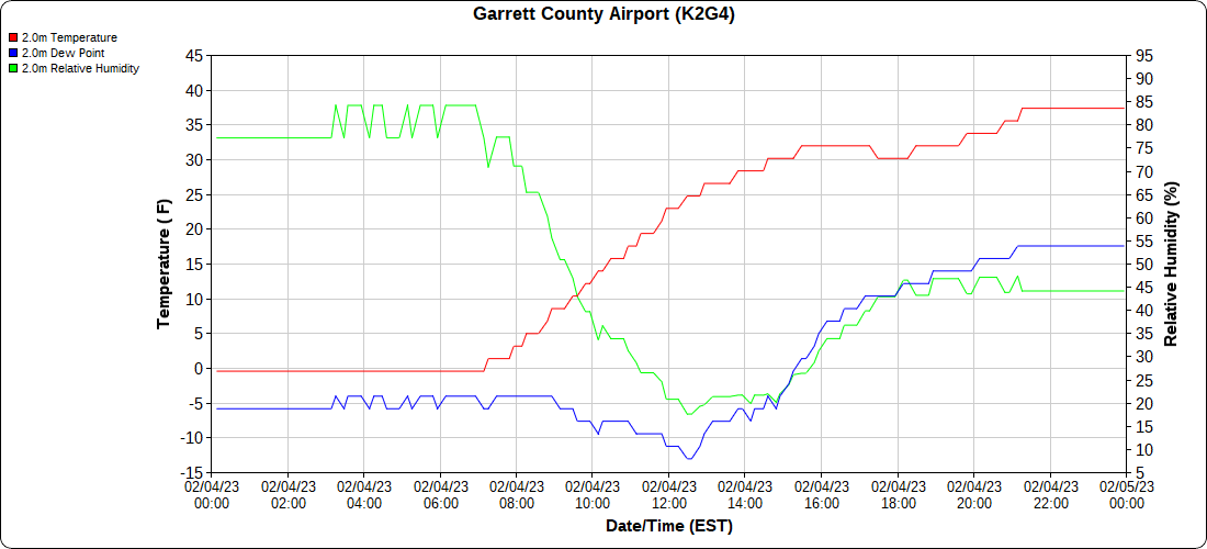
Garrett County Airport
Top of Wisp
Canaan Heights/Davis 3SE
Comments and data by Dave Lesher at:
http://data.canaanmtnsnow.com/
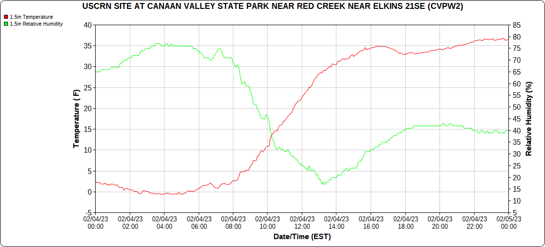
Climate Reference Network Canaan
Atop Canaan Ski area
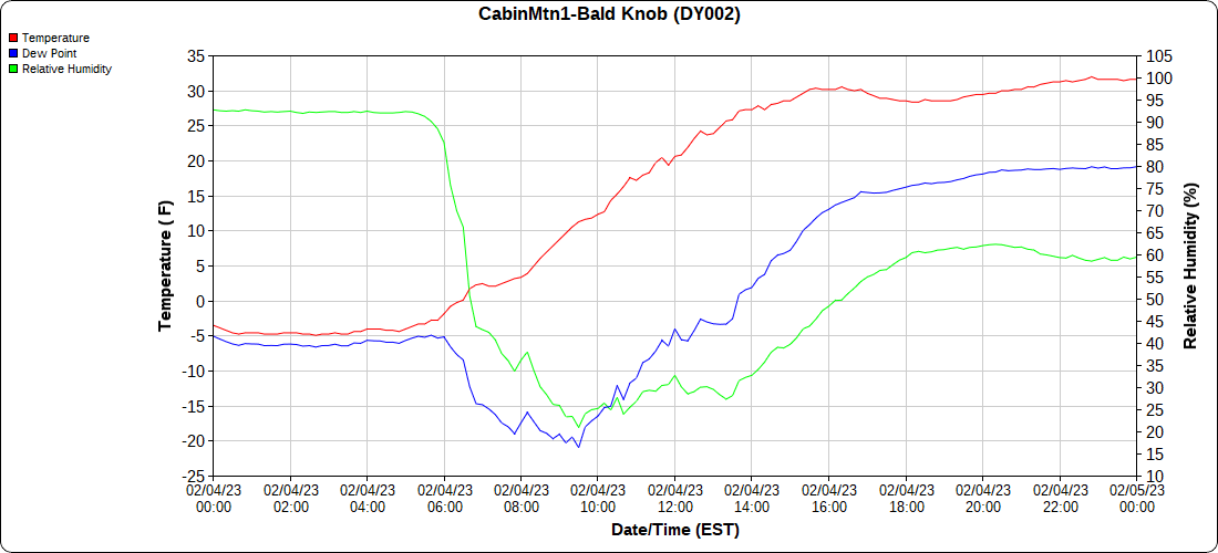
Cabin Mt at Bald Knob
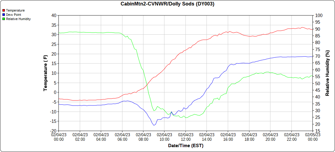
Cabin Mt-Western Sods
Spruce Knob
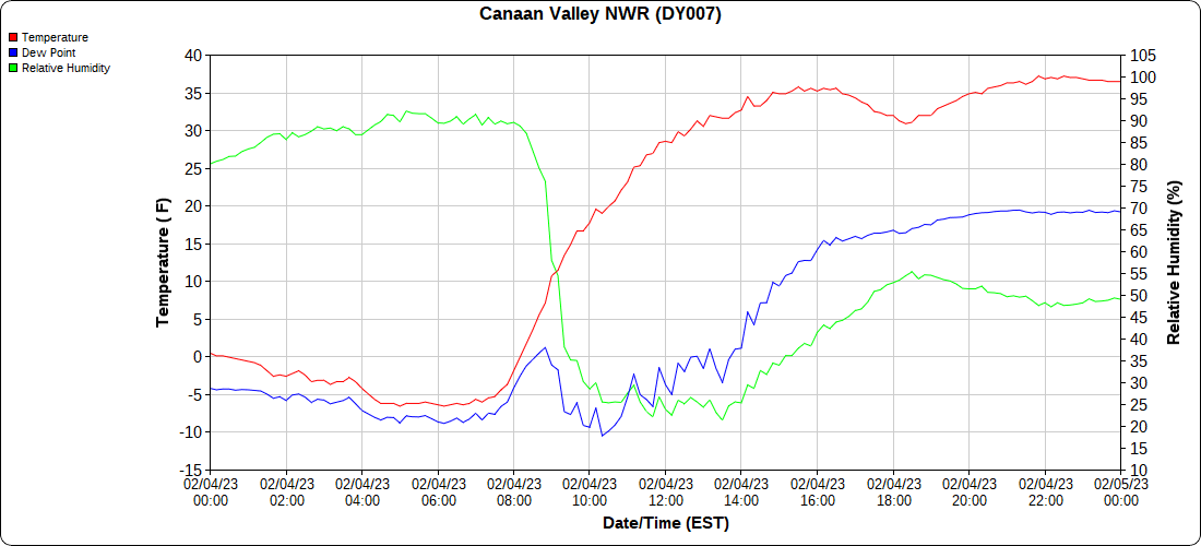
Canaan Valley Refuge
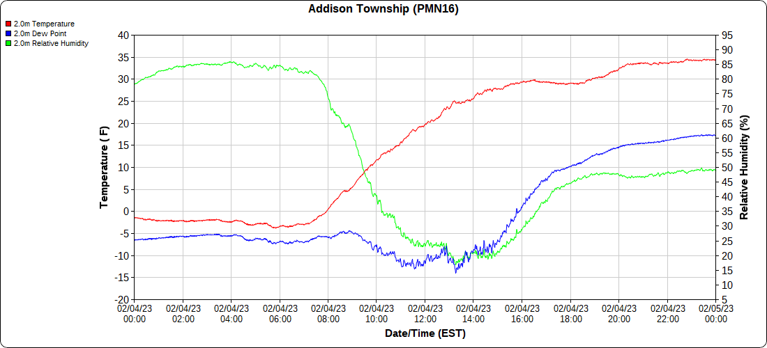
Mt.Davis
Snowshoe
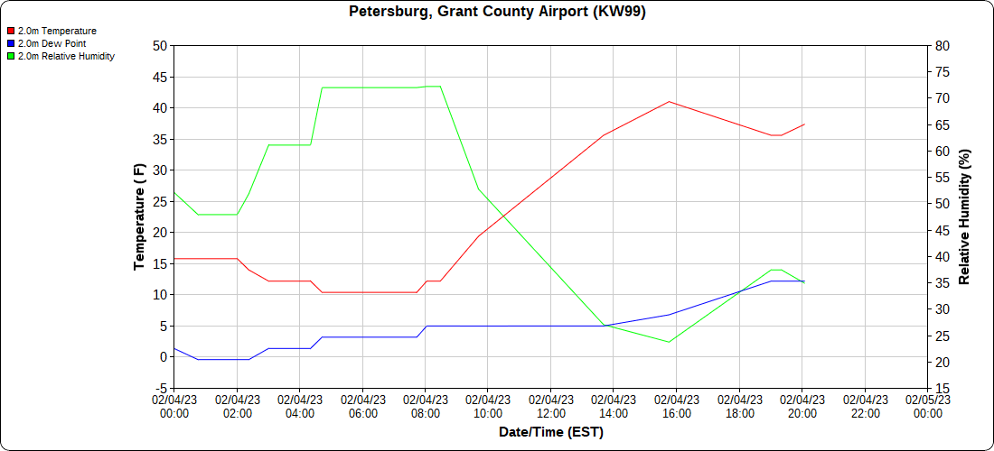
Petersburg Grant County Airport
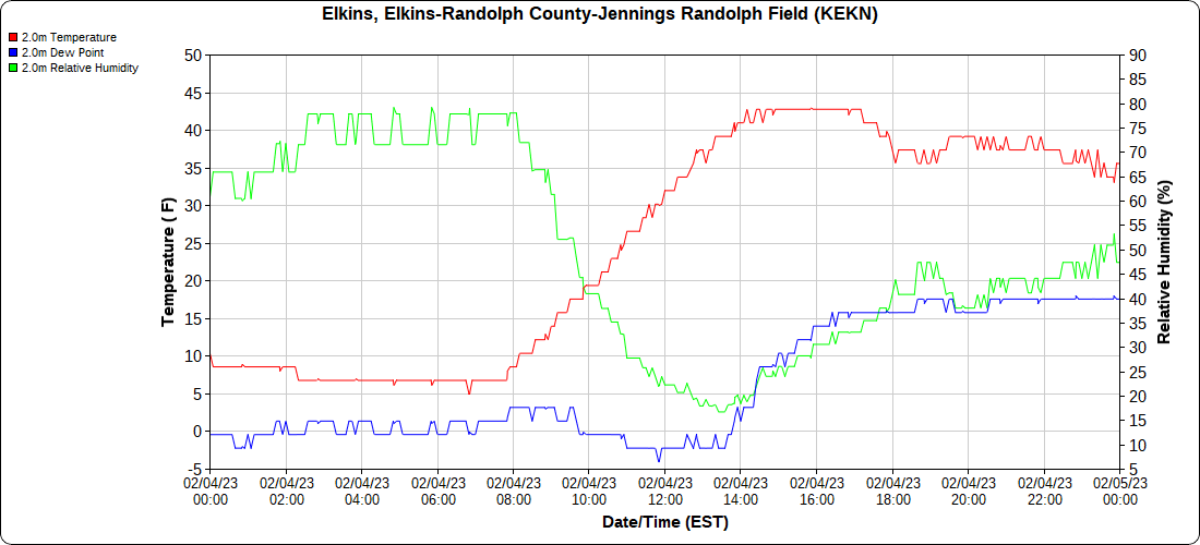
Elkins Airport
Dy007-Canaan Valley Refuge 3150′, Dy002-Cabin Mt at Bald Knob 4350′, Dy003-Cabin Mt-Western Sods 4035′, Dy004-Spruce Knob 4820′, Cvpw2-Climate Reference Network Canaan 3380′, KW99-Petersburg Grant County Airport 961, K2G4 Garrett County Airport 2933′, KCBE Cumberland Airport 774′, KEKN Elkins Airport 1985′, KMGW Morgantown Airport 1227′, PMN16-Mt.Davis 3038′, KDCA-Reagan National 15′, G1472 Snowshoe 4500′
The Valley vs Cabin Mt
Canaan area temps
High Ground Comparison
Up High and Down Low
Up High, High Valley, Low Valley
The Valleys
WV High Ground Cold spots vs DCA
RTMA
Radar
void
Satellite
Flow
Surface Features and 500mb Height anomalies and Flow
Grantsville
towards Frostburg
Lavale to Cumberland
Flintstone
Polish Mt
Town Hill
33 east of Harman at the Divide
Seven Springs
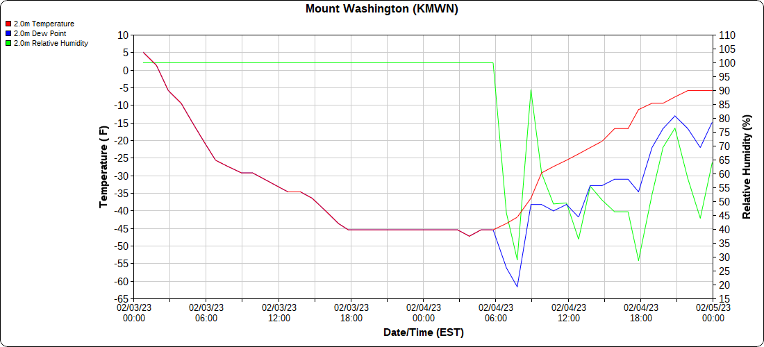
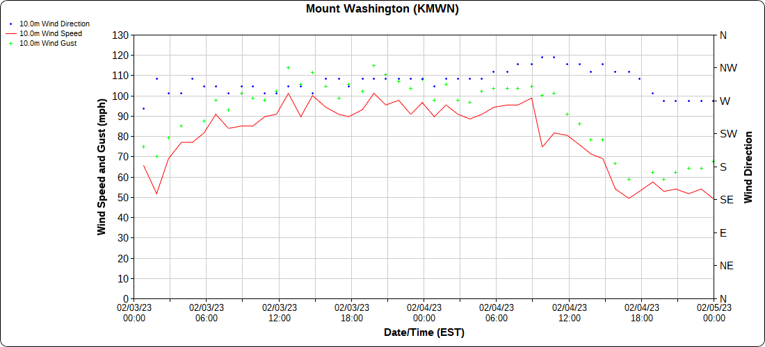
Mt.Washington setting records
Assigned to forecast a generational storm for New England over the past few days, this team also endured the extreme conditions on Mount Washington’s summit as an Arctic air mass plunged temperatures to at or below -45° F for 13 hours. Wind gusts of 120mph and higher drove the wind chill below -100° F for 15 hours.It was all-hands on deck for Weather Observer & Meteorologist Alexis George, Weather Observer & Education Specialist Francis Tarasiewicz, and Summit Intern Karl Philippoff. Knowing Mount Washington Observatory’s record low of -47° F might be broken Friday night (Feb. 3) or Saturday morning, the team geared up to guard against extreme cold every 15 minutes through the night, opened the door, and walked onto the observation deck to measure air temperature with the sling psychrometer, a type of instrument used since our founding.This is typically done hourly. They wanted to “sling” more often to ensure frequent measurement. At around 4:00 a.m. today, Feb. 4, they recorded a -47° F temperature, matching the Observatory’s record low set in January 1934.Mount Washington State Park employees were there to help out. A door at the Sherman Adams Building failed during peak winds, and State Park employees secured the building. Shown in the second image are Nate Camille, left, Steph Moore, Patrick Luddy, Alexis George (holding the Hays Chart), Karl Philippoff, Francis Tarasiewicz, and Christopher Lavigne.The third image shows the Observatory’s B-16 daily weather form, with our station’s record low being matched around 4:00 a.m. this morning. The measurements have been added to our 90-year digital temperature record.


