Partly sunny start, clouding up mid morning,,light freezing rain briefly late morning, a lull then it picked up mid afternoon and everything became a glaze into the evening. Using temp profile below, easy to pick out the areas impacted.
Temp profile this afternoon
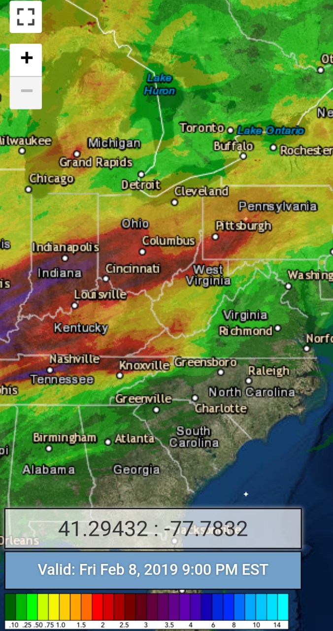
Radar
Satellite
Flow
Surface features and 500mb height anomalies and flow
Few clouds this morning early, giving way to blue skies. A rarity over the past year. More clouds south and north. (See Satellite) as well as southern Wv with a little snow(see radar)
Temp profile this afternoon
Radar
Satellite
Flow
Surface features and 500mb height anomalies and flow
Snowcover, north central Garrett County and points north, and northeast. These are the typical cutoff zones of where winter in these big SE ridge patterns can survive a little.
Satellite today, some clouds in this image but snowcover visible
Here’s a look from near Swanton
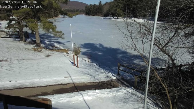
New Germany State Park
Grantsville area
Springs Pa
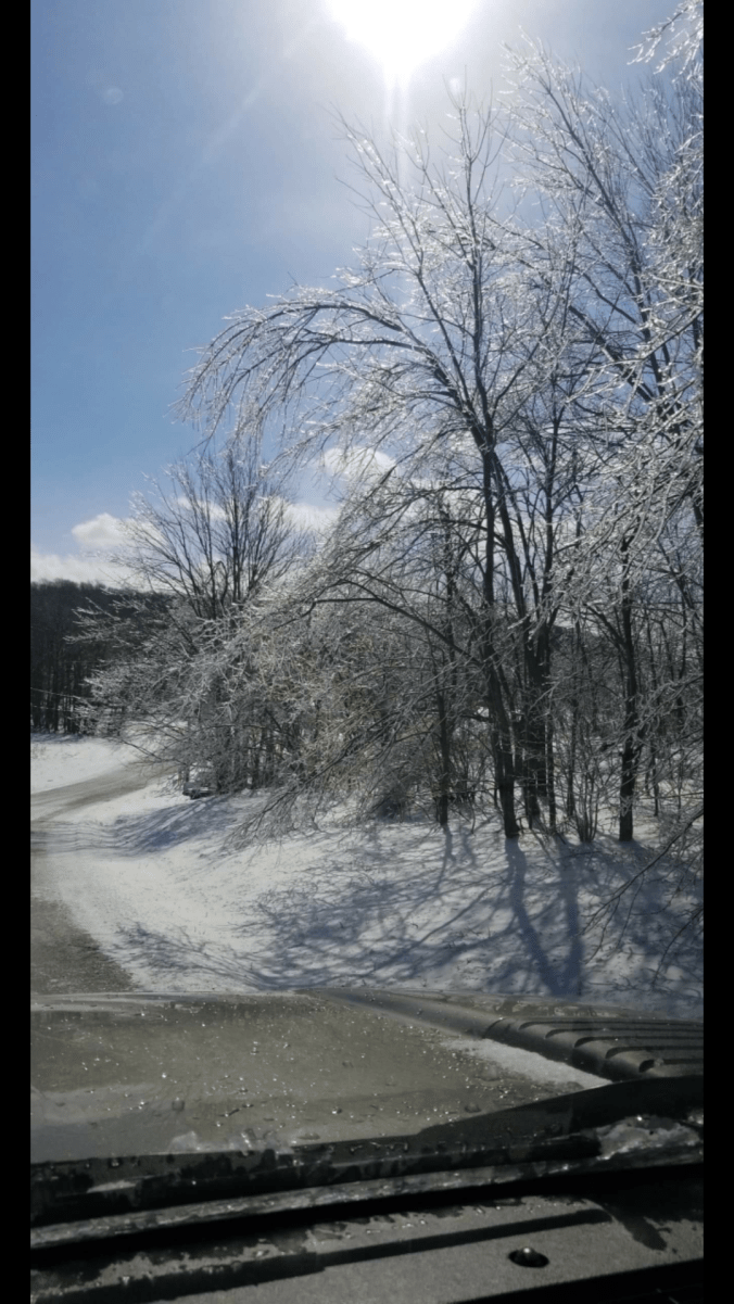
South of Grantsville, Amish Road to Bittinger 2nw Valley. As you go south here, open areas are bare, wooded, sheltered areas with snowcover
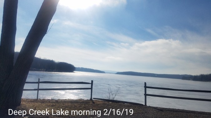
Deep Creek Lake , snowcover all pretyy well gone in this area, lake iced over well yet with ice fishermen out .
Also refer to the webcam videos above with the difference of snowcover from Northern Garrett to Rt 40 Elementary. Those typical boundaries at play and the upcoming pattern throws these same boundaries in play more.
Rt 40 cam down due to power outage in the area. Replaced todsy with FSU cam
Canaan Cam offline
Feb 13(Wed) min max avg
Bitt 2nw Valley
Garrett College
Can-Heights
CRN-Canaan
Cabin Mt
Cabin Mt north
Spruce Knob
Snowshoe
Can-Valley Floor
Can-Valley Floor N
7Springs
Snowshowers, very windy, few breaks in cloud cover. Some heavier pockets of snow. Last night, the heavy hit ice zones lost some ice with the 2-2.5 hours of above freezing. Some ice remained and some of the valleys east of Meadow Mt and areas east of Meadow held onto most of their ice. Resulting in downed trees. power outages.
Temp profile this afternoon
Radar
Snowfall- Picked up 1.2″ overnight at Bittinger 2nw Valley through 6am with another .6″ today
Satellite
Flow
Surface features and 500mb height anomalies and flow
Cloudy day, fog at times, strong SE,E flow. Sleet ovenight with freezing rain. Freezing rain today, continuing beyond 9pm in areas Heaviest freezing rain 2pm-8pm.
Temp profile this afternoon
Radar
Snowfall- Picked up .3″ Sleet overnight at Bittinger 2nw Valley . 61.5″ on the season
Satellite
Flow
Surface features and 500mb height anomalies and flow
Pics today
3km Nam the far superior model in these setups, but the ICON-model has been doing a decent job as well.
Speaking of 3km Nam . Looking at wind gust tonight into tomorrow. In the 40-50mph range with higher in the higher exposed Wv mts. Also easy to pic out the milder west flow entering Garrett County after 9pm
NWS continued struggles with this setup
The forecast yesterday showed this going to plain rain by 8-9am, and 10am. No model data available to the public supported that. The 3km Nam ran temps at or below freezing until 6-8pm. And it often is a tad fast exiting it, and tonight we saw Mchenry run to 8pm freezing, New Germany State Park beyond 9pm. 12 hours later than the NWS forecast. They changed it this morning to 3pm, with Winter Storm warning ending at 1pm, then switched to 4pm. Why it was not extended again, and why it was not extended yesterday through the evening hours is again based off a poor system they use to project temps. This has been a repetitive fail on a consistent basis for years in their forecast.
Snow transitioned to mainly light rain pre dawn. Some wet flakes mixed in around 9am. Mainly light rain today. Temps began falling 3-6pm and freezing rain commenced. Western areas later. After dark snow/sleet Savage Mt, freezing rain west.
Temp profile this afternoon
Radar
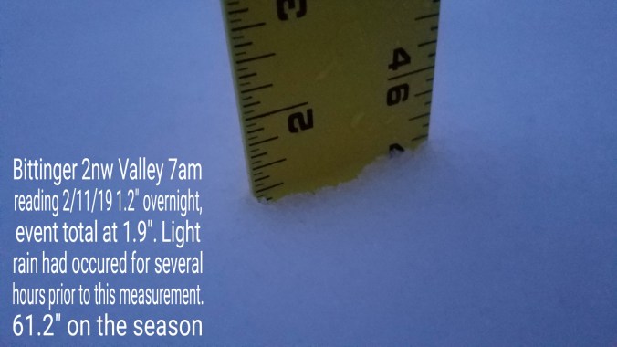
Snowfall-picked up 1.2″ at Bittinger 2nw Valley through 7am. Snow at that time had been light rain a few hours. 61.2″ on the season
Satellite
Flow
Surface features and 500mb height anomalies and flow
Day started off clear, calm, very cold valleys. Clouds built, thickened, lowered through the day with snow breaking out mid to late afternoon (4pm+/-) and steady into the evening.
Temp profile this afternoon, milder surge into Tucker area
Radar
Snowfall – Through 6pm boardsweep .7″ had fell at Bittinger 2nw Valley. I went ahead and did this measurement as temps expected to creep up by next measurement at 6am.
Satellite
Flow
Surface features and 500mb height anomalies and flow
Cloudy, windy, rain overnight, turning colder at dawn. A brief snowshower around 8:30 as precip ended. Then windy turning colder as skies broke for the afternoon.
Temp profile this afternoon
Radar with radar estimates past 72 hours
Satellite
Flow
Surface features and 500mb height anomalies and flow
Few pics today…and the surviving snow at Bittinger 2nw Valley