Mainly sunny day, few passing clouds. Windy afternoon.
Temp profile this afternoon
No precip past 24 hours
Satellite
Flow
Surface features and 500mb height anomalies and flow
On the models….
A developing Nor’Easter this weekend continues to adjust run to run on the models. It’s still early to make a clear cut call. Models have trended to this-
1- temps do look like the may be just mild enough for a cold rain event
2- a dropping upper level low may provide some wet snow early next week
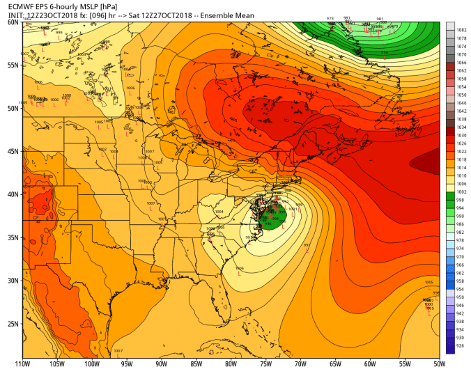
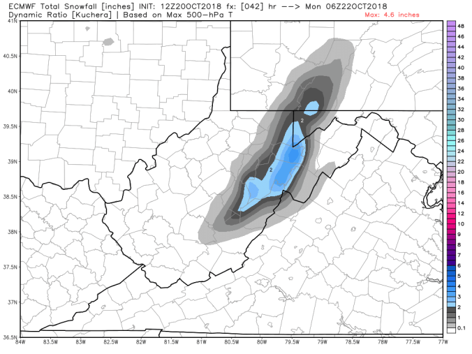
By no means is that etched in stone. Let’s look at the ECMWF low locations Saturday morning.. That doesn’t look like a lot, but it’s enough to play a big role in a borderline precipitation event.
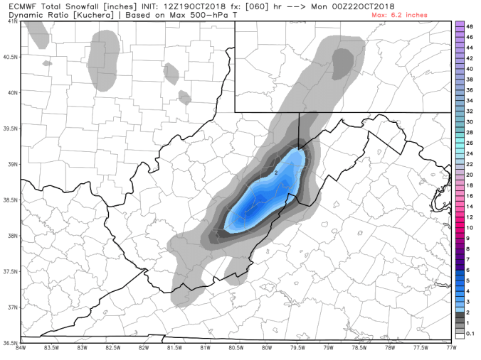
Snowfall off the 12z ECMWF ensembles. It’s less than previous, but some members still see appreciable high ground snow with the event.
The operational ECMWF today has a odd scenario. Precip breaks out as snow and as precip builds heavier, it changes to rain in the high ground. That’s a red flag. The 12z ECMWF akso brings best accumulation with upper level low early next week. LOTS of tweaking and adjusting over the next 2 days
Mainly clear skies, only a few clouds today. Light breezes and low dew points. Those low dew points allowed the light snow covering today to remain on some north facing areas and shady spots. Many only look at temps when it comes to snow melt. You will melt more snow with temps upper 30s, with dewpoints upper 30s vs 50° and dry air.
Temp profile this afternoon with dewpoints
Dry period- no radar or estimates
Satellite
Flow
Surface features and 500mb height anomalies and flow
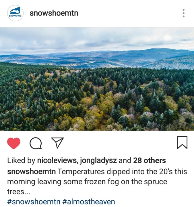
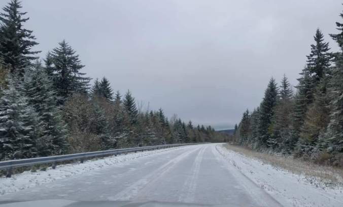
Pic by Jonathan Gladysz at Red Spruce Knob this morning
On the models…..
A developing nor’ easter this coming weekend. Track, intensity are HUGE question marks. Further east, weaker, its a light rain, rain, snow mix. West on the coast, and strong, more likely the mountains get an appreciable winter event out of this. Details are sketchy, confidence is low. So, keep this in the back of your mind that this potential exist for the weekend. Will resume graphics tomorrow..
The range of impact currently insignificant to major. The major impact would be a intensifying nor’easter, drawing in cold air, lift over mts, a wet heavy snow on areas where foliage remains. Oak areas, beech, lots of leaves on certain tree types, so power outage issues would occur under a scenario should this turn into a big ticket winter event. No hype, not saying its coming, not saying its not. Bottom line is, it is a unknown and lots of model variation.
Extended beyond, a shot of Indian summer may work in for early November.
Overnight snow, a few pockets of light snow scattered about today. High ground fog. Otherwise it was just a mainly cloudy day. Snow cover remained all day.
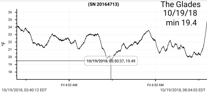
Temp profile this afternoon(Wv high ground above 4000′ holding lower to mid 20s all day. Northern Cabin had wind gust over 50mph later yesterday.
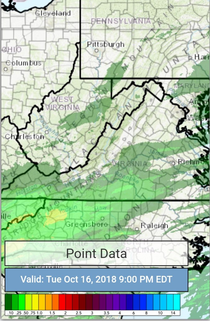
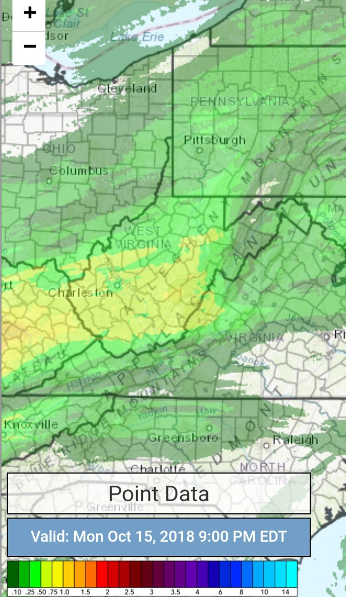
Radar with estimates 9pm-9pm, I didn’t get the graphic in, in time yesterday, so going with 48 hour totals vs the typical 24.. At Bittinger 2nw Valley coming in a .62
Snowfall
1.0″ at Bittinger 2nw Valley
Davis 3SE/Canaan Heights 2.3″
Snowshoe 3.0″
On Bald Knob, I’d estimate right around 3″.
Satellite
Flow
Surface features and 500mb height anomalies and flow
Pics today
Pics by Dave Perrine at Spruce Knob
Pics by Gerri Ann Atkinson at Gaudineer Knob
Pics by Walter Scriptunas II at the Cass Scenic Railroad to Bald Knob in Pocahontas County
Check out his photography work on his photography page on Facebook
Pics by Jonathan Gladysz at Red Spruce Knob
Pic by Rosanna Springston at the Highland Scenic Highway
Pics by David Faunce at Pendleton Lake at Blackwater Falls State Park
Videos today
On the models
A semi tranquil, chilly week ahead. Then eyes turn to a system coming up from the south. Track, intensity, timing will have a impact on whether or not this sets up as a early season wet heavy snowfall for the Alleghenies. As of now, this is the ticket to watch.
Cloudy, light rain to start, some afternoon breaks and showers returning late day. Windy
Temp profile this afternoon
Radar with estimates 9pm-9pm
Satellite
Flow
Surface features and 500mb height anomalies and flow
On the models….
Will post the latest Ecmwf run….. Thoughts on the event overnight into tomorrow have not really shifted or been tweaked at all. Please refer back to that posting for details.
12z ECMWF precip type next 240hrs
12z ECMWF 2m Temperatures next 240hrs(10 days) 10/20/18
Clear, start. Calm valleys, light southerly winds up high. Gave 20°+ temp swings from cold high valleys to high ground. Few clouds coming in during the afternoon and evening.
Temp profile this afternoon
No rain, nothing on radar past 24, straight to todays satellite
Satellite
Flow
Surface features and 500mb height anomalies and flow
Pics today
On the models….
Showers pushing in late tomorrow, quickly changing to snow overnight. Some heavy burst possible. Strong NW winds. Falling temps. I would expect at the least, the exposed, windy areas will have some snow covered roads. Snowshowers in to Sunday a.m.
Keep in mind, nature of bands may leave areas in forecast zones less or more. Impossible to predict. While a area forecast of 1-2″ one area may end up with 2 or 3″ and pockets less than 1″ in areas that miss out on the precip bands. More of a guide than a rule with the event.
2000-3000′ on the upslope areas of the Alleghenies. Coatings to 2″ . Tweaked upward with it looking to be a touch colder tomorrow night, and there may be a few narrow bands of heavy pockets of snow.
Early clouds, some fog skirting the high Wv ground with a touch of rime early. Then a mostly sunny day beyond mid morning
Temp profile this afternoon
Nothing on radar, so nothing to post for precip
Satellite
Flow
Surface features and 500mb height anomalies and flow
Some pics today
Pic from social media at Snowshoe early morning
Speaking of early morning cams. I have been fooled many many many times over the years by predawn and nightime artificial lightning on these cams illuminating grass, bare grass. Sometimes its wet grass. It illuminates it, in a way that looks like snow. I’ve seen it occur with temps in the teens and no predawn meltoff. The snow that appeared on the ground at the base of Snowshoe, wasn’t snow. It was wet grass illuminated. Look at this morning at Silver Creek. This was predawn, to at first light when the cam does not illuminate the image. Looks like snowcover, none there. You will observe this often, and be fooled often. Even the NWS has been.
On the models…
Fast forwarding to Saturday to showers pushing in, and changing to snow overnight. A quick brief hit. Thoughts have not changed really since last night. 2000-3000′ coating to 1″, 3000-4000 1-3″ my tweak would be 4000’+ 2-4″. Windchills into the single digits above 3800′ Sunday a.m. 12-20° 2000-3800′. Air temps 20-25° to start Sunday above 3200′, 25-32 2000-3200′. Max temps 28-34 above 3500′, 33-39 2500-3500, 38-43 2000-2500. Sunday night, if skies clear fast as they look they will and winds go calm, thats iffy, but if they do, low temps falling 6-12 in the coldest high valley pockets. 15-25 elsewhere.
Mix of clouds and sun and windy would sum up today.
Temp profile this afternoon
No precip 9pm to 9pm,so take a look at the wind gust, over 50mph gust on northern Cabin, Mt Sods. The RTMA looks pretty good over the high ground.
Satellite
Flow
Surface features and 500mb height anomalies and flow
On the models…
The fun part. Cold night tonight, some places down to freezing or below for the first time. High ground has been there done that on numerous occasions. Chilly tomorrow, windchills 10-15 to start Wv high ground, 20-25 elsewhere, moderation of temps Friday, Saturday…then…
Some showers look to arrive Saturday, overnight those showers look to change to snowshowers into Sunday morning. Changeover first in the high Wv ground, then working down to around 2000’… Very early low confidence call. 2000-3000 coating to 1″, 3000-3500, 1-2″ 3500’+ 1-3″ . Above 3500′, temps will be well into the 20s, strong winds. That will quickly chill the uninsulated duff layer(leaves, grass, spruce needles, moss, etc) and snow will stick. The warm ground becomes more of a factor after 1-2″ accumulates, then that duff layer is insulated with snow and the ground warmth melts from undeneath. Below 3000- 3500, temps become more marginal, although the same principles, just a slower process to stick. Although a heavy burst can overcome that slow process. Monday morning, high pressures follows in the wake of the brief hit, that will lead to clear skies, and probably calm winds. Coldest high valleys Monday a.m could push 10-15° if skies clear, winds go calm. (Perfect setup could yield colder in those coldest pockets) Something to watch for. Most locations in the 20s.
12z ECMWF precip type next 240hrs
12z ECMWF 2m Temperatures
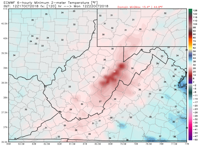
Heres the Monday a.m min off the 12z ECMWF. Not a strongsuit of the model. It does however see a little snowcover Sunday, into the night aiding the valley cooling. No snow, the model won’t show that low. Thats about the only time the ECMWF will model lower temps than the GFS is with snowcover. Also keep in mind, it’s a 9km grid model, it will not pick out valleys well.
12z ECMWF windchills
12z ECMWF snowfall. Its the most robust of the models. The GFS though has slightly crept up, as well as the Canadian. The 12z ECMWF is backed by quite a few ensemble members. So the call is presently based off a blend of the models. 2 things also to hinder modeled totals. The very onset will take time to stick, and once it does stick, accumulate a little, insulates the duff layer. Warm ground will play a role,,especially in non windy areas. In windy areas, snow sticking to roads would be possible. I stress, 4 days out, low confidence in saying that. Just something to be mindful of come Saturday night, Sunday a.m. Photographers may have a morning to get some snow on some remaining foliage. Birches, beech still in the changing stage, maples done pretty well, oaks green with brown blotches. Oak is not abundant across the highest Wv areas. In areas with oak, accumulations look light enough no issues would occur.
Cloudy, showers breaking out mid morning, on and off all day. Turning windy. The peaks of blue you see off the Rt 40 cam, never saw that back towards Bittinger, Mchenry.
Temp profile this afternoon
Radar with estimates 9pm-9pm . Picked up .25 through 6pm at Bittinger 2nw Valley
Satellite
Flow
Surface features and 500mb height anomalies and flow
Pics
On the models…..
Cold air returns overnight after the hiatus today. Dropping temps, lowering dewpoints, and things drying out. Finally. Areas at or below freezing in the morning. The chill holds through the week, with Thursday a.m being the coldest period. If things go calm pre daybreak, coldest valleys see teens. If winds hold up just a little, as it looks like now they may, high ground will see the coldest temps with mins 21-25. Most all areas below freezing Thursday a.m. If you’ve not seen a frost, freeze yet. Thursday a.m should change that. Watching the weekend with some rain to snow. Possibly some light accumulations Sunday. May be a good period to get some some snow on foliage pics in the Blackwater Canyon if this pans out, stay tuned. If it occurs, its likely not exclusively only above 4000′. Long range, cold shots and precip opportunities. Can they match up for a early season thump? The potential is most definetly alive.
18z 3km Nam 2m temperatures
18z 3km Nam 2m Dewpoints
18z 3km Nam Windchills
18z GFS precip type next next 384hrs
18z GFS 2m temperatures next 10
Little peak at some of the 12z ECMWF ensemble members on snowfall next 15 days. Potential is there.
(The 7Springs 2900′ appears to be calibrated low for readings. The difference in 400′ seems to great for max temps often)
Cloudy start, a period of morning rain, cloudy afternoon with some mist, fog around 6pm, transitioning to a light rain 9pm.
Temp profile this afternoon
Radar with estimates 9pm-9pm. Rainfall of .15 at Bittinger 2nw Valley today.
Satellite
Flow
Surface features and 500mb height anomalies and flow
Pics….
Most of these around the Cunningham Swamp. Lots of maple in this area, some cherry…few oaks. Hillsides 80-90% bare.
On the models…..
Showers tonight, Monday, before clearing off overnight Monday. That should setup Tuesday a.m as the most widespread morning with temps below freezing across the valleys. A chilly midweek. I think Thursday a.m should see the coldest pockets run temps into the 15-20 range to start the day. Most widespread killing frost/ freeze… Next snow potential to whiten things, currently looks like next Sunday, low confidence in that 7 days out.


 No rain, nothing on radar past 24, straight to todays satellite