December 4.         min.      max.      avg

Bitt 2NW valley  21.1        48.0        34.5

Garrett College    24.7      53.8         39.2

Can-Heights        27          52.8         39.9

CRN-Canaan      24.3        54.1         39.2

Cabin Mt           32.9         50.9        41.9

Cabin Mt north 34          50.9        42.5

Spruce Knob    33.3        46           39.7

Snowshoe/S.C  33.3       42.4         37.8

Can-Valley Floor 11.9

Cresaptown      27.3       55.4        41.3

Green Bank Obs 18.5     51.1       34.8

7Springs           33.6        52.6        43


Clear overnight, light SE breezes up high, calm valleys. A large temp variation. Pics added of that. Mix of clouds and sun with clouds increasing at nightfall. SE breezes dominated the daylight hours and created a temp setup that is typical of the situation and one the 3km nam excels at.

December 3.          min.       max.       avg

Bitt 2NW valley   22.5        45.7        34.1

Garrett College   26.7        48.1        37.4

Can-Heights        27.7        43.5       35.6

CRN-Canaan     26.8         45.8       36.3

Cabin Mt           29.8          42.4      36.1

Cabin Mt north 33.4        41.4       37.3

Spruce Knob     30          42.8       36.4

Snowshoe/S.C   32.7       42.4       37.6

Can-Valley Floor 14.1   47.9       31

Cresaptown       29.7     60.8       44.9

Green Bank Obs 21.9   55          38.5

7Springs            33.5      47.1      40.2

Pretty well a clear start to clear finish. A period of cloud cover and widely scattered light shower occured last night. Temps in the valleys spiked up, then fell again at daybreak.

Supermoon…nice viewing for that. 3rd image is edited, by combining 2 pics.


December 2        min.       max.        avg

Bitt 2NW valley  20.0       46.7        33.3

Garrett College  24.2        49.2        36.7

Can-Heights       30.3        45.3        37.8

CRN-Canaan      33.3       47.3         40.3

Cabin Mt           34.3        43.7         38.5

Cabin Mt north 31.1      41.9*        36.5

Snowshoe/S.C   35.4      45.7          40.3

Can-Valley Floor 14.5   49.4          31.9

Cresaptown      25.7      53.1         39.4

Green Bank Obs 20.8    55.5        38.2

7Springs          29.8        45.4        37.6

Cold valleys overnight. Very white and frosty to start in cold spots. Some high ground remained above freezing overnight.

Times of clouds and sun today. Variable breezes.

Spruce Knob station put in by Vtech. Will begin listing it tomorrrow.

Overnight Cabin Mt ran 20°+ warmer than the valley. The valley was frosty white in the a.m. Pictured is a timeline of some of the variations between the 2. Can-Valley Floor min occured just prior to timeline on the image. Min of 14.5°


Screenshot_20171203-131725.jpgScreenshot_20171201-074107.png

December 1.           min.      max.       avg

Bitt 2NW valley   22.1        41.4        31.7

Garrett College   25.8         45.7        35.8

Can-Heights       29.2          43.4        36.3

CRN-Canaan      28.4          45.9        37.1

Cabin Mt.           28.2          43.2        35.7

Cabin Mt north 30.6         43.7        37.2

Snowshoe/S.C    28.6        43.3         36

Can-Valley Floor 15.9      50.0         32.9

Cresaptown          29.5      56.7        42.8

Green Bank Obs  22.4      56.1         39.2

7Springs                30.2      43.2         36.7

Fog, clouds departing just prior to daybreak. A period of ground fog occured after dawn. It faded into a period of sun, to cloud cover, back to clear skies in the afternoon.

Cold air was a little more entrenched north, although Wv high ground ran nearly identical to the northern most locations.

* Cabin Mt north, technial issue, recording max, min as it shows, but it was down a few spells.

Outlook off the models

Euro weeklies are in and they are looking cold. Beginning mid to late next week, we begin our progression into a winter pattern. While these 7 day intervals are all locked into cold, I expect 1-2 day hiccups at random with milder shots in a overall cold pattern. Those run into January

CFSV2, mid to late next week into January. Its looking very similiar to the Euro weeklies in the overall setup.

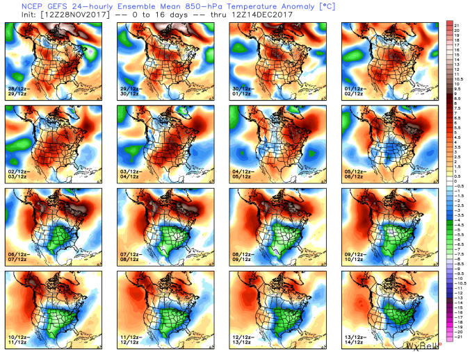
0z Euro ensembles off todays run. Afternoon to Afternoon mid next week on.. Next week likely the step 1 in a 2-3 step to some very cold weather.

Ensemble means off the Canadian. Very much in line with other modeling..

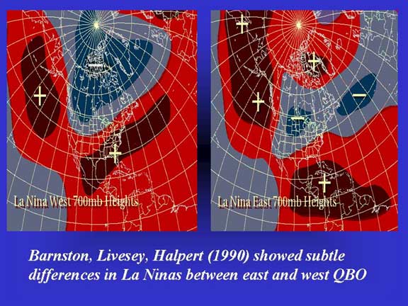
6z GFS ensembles…much in line with other modeling. I think the gfs is most interesting of the bunch in terms of snow potential. Its more classic east based La Nina, negative qbo look. Hints of a SE ridge thats much further south than what exist with a west based La Nina and west QBO…like last year, not to mention, cooler water vs last year off SE coast.

144_7-1

Very much what modeling is going to.

Teleconnections off the Euro ensembles. NAO weakens, as its doing so I think thats one shot at a coastal storm and likely a coastal storm thats moving along at a good clip. Entirely way too early to go into any type of detail in any way shape or form. The biggest teleconnection factor in my opinion near term will be the + PNA, -EPO, -WPO…a product of the Pacific SST. . Cool pool east of dateline, 30-40N, and warmth along west coast.  This evolved within the past month to a more favorable look. The pattern becomes more amplified. With a negative QBO, which tends to favor a -AO, it sort of goes hand in hand. SE ridge much further SE, we have no SW flow aloft, and the cold can come, and hold, unlike last winter of quick hits and retreats..

My least favorite aspect of the models is snowfall….Why? Simply because the models will not hit where a low pressure is going a week to 14 days out.

Having said that, it does give looks of potential, and what makes the most sense in the overall setup.

For what this aspect is worth, in the next 10-20 days. I think the pattern favors 2 events riding up the coast. First one is a wave that forms on the cold front mid next week. Overall I think its rapid through and not much of a snowmaker when the cold comes. Like always, needs watched. Only opinion on what fits the current look that can change. I think the pattern favors some diving clippers, with situations where we are very cold and temps jump to the 30s as the low is coming into the Ohio valley, and snow breaks out and a sharp drop occurs. These setups usually have good ratio snows and windy conditions that follow. The overall setup is not unlike the cold of 13/14, 14/15. I currently do not think it goes to those levels yet.

A look at the Euro products for Garrett County area, and Elkins.. This will adjust, and in time with a snowcover present, I do think below 0 valley nights will occur in this pattern. At times high ground struggles 10-15 for max temps, -5 to 0 for lows. I think in the next 10-20 days once the cold comes those will be occurences we see. With hiccups. Should a storm cut west, that can always usher in a day or so warmup in a cold pattern. That is something to watch, but overall it appears the cold pattern is dominant when it comes and quite contrary to last winter where 2 cold days were followed with 5 mild, we may reverse that and then some…stay tuned…

November 2017

November 2017 in the books…

One very alarming, at the same time sad thing stands out. The poor Oakland MMTS siting is absolutely ruining the numbers, which affects the long term running mean and all the work of the past 100+years of data collecting. Its a crying shame to see. Its very obvious.

Overall November 2017 will go down as a slightly below normal temperature month, but also a very dry month. Due to the very dry air, remnants of Nov 19th snow remained in spots until today. Which was only a 2-4″ snowfall, and thats quite incredible given the temps the past 10 days. Low dew points, low sun angle, short days, allowed north facing slopes, shaded areas to retain very light patches. Talking very minimal, but existent in spots. Thats reflected in my daily post.


November 30.         min.       max.     avg

Bitt 2NW valley     26.2         57.4      41.8

Garrett College     28.9         58.7      43.8

Can-Heights         36.9         55          46.0

CRN-Canaan        35.3        56.3       45.8

Cabin Mt              33.8.       52.5       43.2

Cabin Mt north  35.1          52.3        43.7

Snowshoe/S.C    36        49.8          42.9

Can-Valley Floor 23.8     58.4        41.1

Cresaptown       33.1       57.8         45.4

Green Bank Obs 26.8     58.5         42.7

7Springs             36.8       59.7        48.2

Clouds gave way to sunshine, frosty in some valleys. Had frost at Bitt 2NW valley. Clouds moved back in later in the afternoon and gave way to rain after dark. There was spotty showers prior to dark.

A reported 4.4(may be adjusted to 4.1) earthquake in Deleware. Felt from Baltimore to NYC.

November 29.          min.        max.      avg

Bitt 2NW valley      23.7          51.6     37.6

Garrett College      27.8          52.7      40.2

Can-Heights           29.9           50.6    40.2

CRN-Canaan          29.7          51.4     40.6

Cabin Mt                34.9          47.8     41.3

Cabin Mt north    36.9          46.8      41.8

Snowshoe/S.C       38.8          47.5     43

Can-Valley Floor  21.3         53.0     37.1

Cresaptown          30.2         65.5     47.5

Green Bank Obs  22.4         60.9     41.7

7Springs               37.3          52.9    45.1

Temps rose in high valleys overnight, deeper valleys held colder, high ground remained up, but held steady during the day.  East of the mts temps were much warmer today.

These patches of leftover snow from 11 days ago illustrate just how very dry the air mass has been. Despite temps reaching the 50s on multiple occasions.

Today, some morning cloudiness gave way to more sunshine.

Screenshot_20171129-202430

November 28.       min.         max.        avg

Bitt 2NW valley    24.7       59.8        42.2

Garrett College     30.2       62.3        46.2

Can-Heights         35.7       56.5         46.1

CRN-Canaan       35.0        58.1        46.5

Cabin Mt             37.8       55.6         46.7

Cabin Mt north 37.9       53.6*       45.4

Snowshoe/S.C    38.7      50.7         44.7

Can-Valley Floor 16.4    60.6      38.5

Cresaptown     28.8       63.2        46

Green Bank Obs 20.7   58.3        39.5

7Springs        38.7          62          50.3

Large inversions to start the day. Very mild, but very dry air. Minimal snow melt at the resorts. Sunny, light breezes.

To note, big temp variations after dark from valleys to high ground.

*Cabin Mt North had some technical issues and was down for a spell today. Not positive max was recorded accurately.

gefs_t850anom_16_noram_1Long range, Gfs as well as other models showing the flip to colder weather coming after week 1 in December.


November 27.       min.         max.        avg

Bitt 2NW valley   27.6        47.7       37.6

Garrett College   32.3         49          40.7

Can-Heights        27.7        43.6        35.7

CRN-Canaan      28.9        46.6        37.7

Cabin Mt           24.4         43.2       33.8

Cabin Mt north 26.4      42.1       34.2

Snowshoe/S.C  26.1       40.8       33.3

Can-Valley Floor  21.1   48.9      35

Cresaptown  34.2         62.8         48.2

Green Bank Obs 21.7   53.6        37.7

7Springs       34.3         48.4         41.3

Almost wall to wall sunny day. Breezy at times. Very dry air mass. Only posting some of the pics with dabs of snow to illustrate how little temps above freezing with the very dry air melt it in shady locations.