November 1.       min.      max.    avg

Bitt 2NW valley  26.5    50.0       38.2

Garrett College  28.0     51.2      39.6

Can-Heights  31.9        53.7       42.8

CRN-Canaan  35.7        55.9       45.8

Cabin Mt       36.1         51.1       43.6

Snowshoe/S.C  37.2      51.1      44.2

Can-Valley Floor  25.2  58.7      41.9

Cresaptown    33.8        51.4      42.6

Green Bank Obs  28.2    59.4     43.8


Cloudy overall today with dim sun and gew very light showers. Perhaps a ice pellet early in northern Alleghenies. SE breeze across Garrett, and central to eastern Garrett remaining cooler with Savage Mt holding 44 for max.  Snow cover dwindled today. Few light patches here and there across Garrett. At 9:30-10a.m Canaan Mt and Mts around Canaan holding decent snow cover up high.

To note, typical situation, setup of 3km nam being far superior to Hrrr with incoming warmth.


Bitt 2NW valley 50° max was very brief in afternoon. Most of day 40-45.


October 31          min.       max.     avg

Bitt 2NW valley 26.7       44.3      35.5

Garrett College 28.2        45.1      36.7

Can-Heights    29           39.4        34.2

CRN-Canaan  28.3        42.3        35.3

Cabin Mt   27.3           37.9         32.6

Snowshoe/S.C  27.9      39.4       33.7

Can-Valley Floor  23.8   45.6      34.7

Cresaptown     34.5        55         44.8

Green Bank Obs  27.8     51.6     39.7

Partly sunny day, low dew points. Minimal snow melt in non direct sunny locations.

From The Snowfall Analysis page

https://www.nohrsc.noaa.gov/interactive/html/map.html?ql=station&zoom=&loc=Latitude%2CLongitude%3B+City%2CST%3B+or+Station+ID&var=ssm_depth&dy=2017&dm=10&dd=31&dh=21&snap=1&o9=1&o12=1&o13=1&lbl=m&mode=pan&extents=us&min_x=-80.966666666669&min_y=37.649999999996&max_x=-77.208333333335&max_y=39.766666666663&coord_x=-79.087500000002&coord_y=38.7083333333295&zbox_n=&zbox_s=&zbox_e=&zbox_w=&metric=0&bgvar=dem&shdvar=shading&width=800&height=450&nw=800&nh=450&h_o=0&font=0&js=1&uc=0

October 30.        min.       max.     avg

Bitt 2NW valley 31.7     41.0       36.3

Garrett College 31.5      42.2      36.8

Can-Heights   26        35.5         30.8

CRN-Canaan 26.5      40.0        33.3

Cabin Mt  23.5           35.1        29.3

Snowshoe/S.C 23       34.7       28.8

Can-Valley Floor 27.8    41.3  34.5

Cresaptown 41.2       54.1       47.7

Green Bank Obs 31.4    49.2    40.3

Snowfall tallies varied south to north. Snowshoe in with a bogus .1″.

Can-Heights 8.4″

Bitt 2NW valley 3.7″

Bayard 3″

Redhouse Md 4.5″

Terra Alta 7″

Richwood 2.3″

reports around Whitmer of 4-5″

Mchenry Md 2-2.5″

Morning began cloudy, windy(as seen in previous post video) fog. Skies began to brighten mid morning in Garrett and midday wv mts. Dew points low, even though highs in Garrett around 40°, snow cover hung on in many spots. Clouds rebuilt back in mid afternoon.


From Satellite view, with brief clearing yesterday, you could see the Allegheny Snowcover with the greatest around Canaan.


https://www.fsvisimages.com/timelapse.aspx?site=doso1

2017-11-05-12-00-09Screenshot_20171029-192814

October 29.       min.         max.     avg

Bitt 2NW valley 32.0      40.4      36.2

Garrett College 32.1      40.3      36.2

Can-Heights     28.1       42        35

CRN-Canaan    28.8       40.7     34.7

Cabin Mt        25.7         45.9     35.8

Snowshoe/S.C  25         45.9     35.5

Can-Valley Floor  29.6   41.7   35.6

Cresaptown  40.3        50        45.2

Green Bank Obs 33.1   50.3   41.7

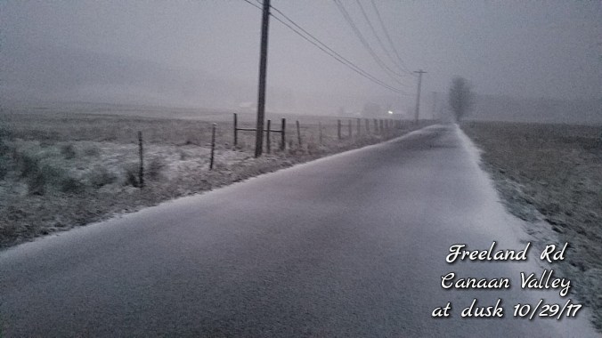
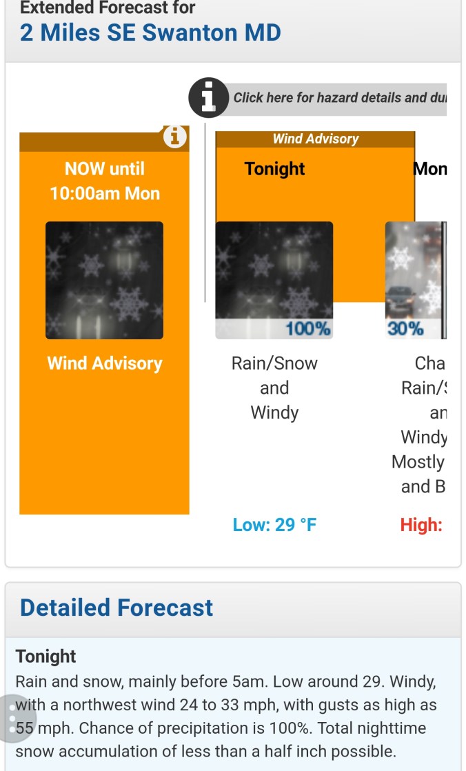
The day began on the rainy side, colder air began transitioning into the southern Alleghenies first. Snowshoe below freezing in the early morning hours as the main precip pulled away from them. Further north, high ground around Canaan went below freezing mid to late morning. A steady light drizzle and fog created a little ice on trees at the highest elevations. This occured also on Backbone Mt. Likely Cabin, Sods, Plains as well on down through high ground. Garrett, Preston,  remained light drizzle. In the afternoon the Snowshoe area began to pick up light snow and the ground was coated by mid afternoon. Highland Scenic Highway was as well. Around 4-4:30 the transition occured around Canaan. Snow, snow/sleet mix to all snow at dusk. The brunt of the moisture remained in the northern Alleghenies. Garrett, Preston went to snow at nightfall and accumulations occured rapidly. Roadway conditions deteriorated rapidly and many many accident reports and road closures due to it. By midnight, the brunt of the snow had fell with remaining snowshowers before daybreak the 30th. The National Weather Service did a absolute horrible job. Calling for less than half inch as all guidance suggested otherwise. Roadways had 2-3″ of snow on them in Garrett, Preston before they put out a winter weather advisory.


Light snow, rime through high elevations from Va, Tn, Nc, Ga…  Mt. Leconte a few inches of snow and 19° in the afternoon

October 28.       min.       max.       avg

Bitt 2NW valley  33.0     61.5       47.2

Garrett College  40.4      61.6       51

Can-Heights   40.4        58.8      49.6

CRN-Canaan.   39.7       59.9    49.8

Cabin Mt.    39.2        57.2        48.2

Snowshoe/S.C 41.4     49.5      45.5

Can-Valley Floor 41.4   62.8   52.1

Cresaptown    37.6       65.8     51.7

Green Bank Obs 32.9   58.4    45.7

Some sun to start. Variation in temps. Bitt 2nw Valley had some a.m frost while Garrett College had temps of 50s. Clouds built in through late morning, showers to steady rain by nightfall.

Lots of places seeing daily mins in the p.m hours.

Posted on Fb page about snow potential tomorrow/night

October 27.          min.      max.    avg

Bitt 2NW valley  25.6      65.2      45.4

Garrett College  27.8      68.3       48.1

Can-Heights      32         66.1       49

CRN-Canaan  32.2       69.1        50.7

Cabin Mt        34          62.4         48.2

Snowshoe/S.C  37.4    60.1       48.8

Can-Valley Floor 19.0    69.8      44.4

Cresaptown    29.3      65.1      47.2

Green Bank Ob 22.7     69.2     45.9


high ground saw temps rise after midnight with breezes kicking in. Valleys remained cold. Temp variances were 20s to 40s at 7 a.m

Skies mainly clear all day.

October 26         min.       max.      avg

Bitt 2NW valley 26.8      45.6       36.2


Garrett College  30.3      45.9       38.1

Can-Heights     30.2        40.2        35.2

CRN-Canaan   29.9      42.9        36.4

Cabin Mt.        28.9         38.8      33.8

Snowshoe/S.C  27.9       38.8      33.3

Can-Valley Floor 19.4   44.8     32.1

Cresaptown  33.4       56.7         45.1

Green Bank Obs 25.1  49.6      37.3

Conditions started off foggy across the high Wv ground. At and below freezing to about 3500′. Light traces of snow to about 3500′ to upwards of 1/2″ on uninsulated surfaces above 4300′ at Canaan with 1/4″ (+/-) elsewhere above 4000′.. A nice coating of rime ice above 3800′. Temps held below freezing through midday up high until more and more sun and clearing melted things off up high. Low spots min temps are p.m and not a.m as they remained +32 during a.m hours.

October 25.           min.     max.     avg

Bitt 2NW valley  31.6       42.9     37.2

Garrett College  35.5       41.4     38.4

Can-Heights        31.9        40       36

CRN-Canaan       33.0        39.2    36.1

Cabin Mt            30            36.5    33.2

Snowshoe /S.C   30            36.5     33.2

Can-Valley Floor 29.8      42.9     36.3

Cresaptown       36.3        56.1     46.6

Green Bank Obs  27.4     47.9     37.7


Conditions started off clear. Thats the reason the valleys have colder 24 hour mins. Cloud cover rolled in and fog across the Wv high ground. Afternoon flakes were reported in Pocahontas County. Fog lowered and afternoon temps fell below freezing across the high ground. Below 3700 remained above freezing. Pockets of brief snow occured in most Wv high ground after dark. Rain, wet flake mix Garrett.