Rain last night, cloudy a.m with sun breaking through as the morning went by.
Temp profile this afternoon
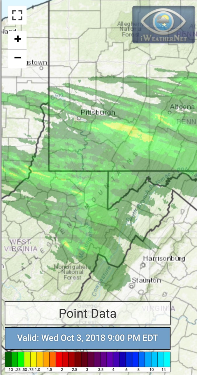
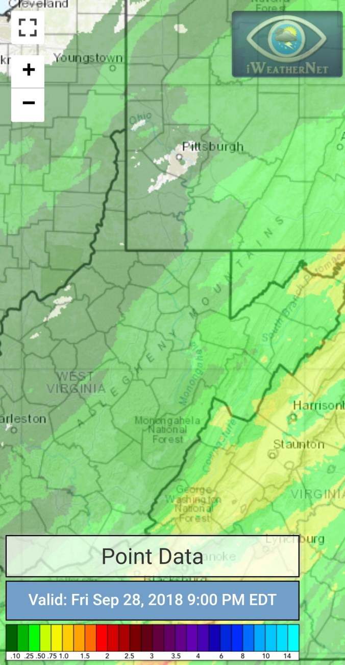
Radar with estimates 9pm-9pm… Picked up .30 at Bittinger 2nw Valley since last evening.
Flow
Surface features and 500mb height anomalies and flow…
On the models……
Ridge east, trough west theme continues. Still correlates nicely with the phase 1 MJO that has held in place. Modeling trying to bring it into phase 2 mid month. If so, cold likely is able to push finally. Wait and see. Short term-
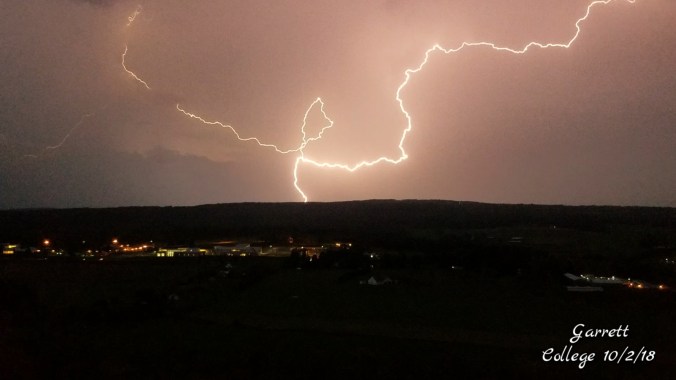
Partly cloudy start to quickly building random storms after daybreak. The low eastern sun, incoming storm, big puffy white and dark clouds gave a weird hue to the morning sky, with even a rainbow forming in the western sky. Morning showers, then mainly cloudy with a few peaks o sun. Late evening storm that put out a lot of severe watches, including tornado.
Temp profile this afternoon
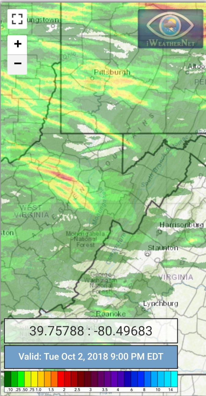
Radar with estimates 9pm-9pm..picked up .05 at Bittinger 2nw Valley through 6pm, that was with the morning showers
Satellite
Flow
Surface features and 500mb height anomalies and flow
Pics today
Late day severe weather…
7 years ago today
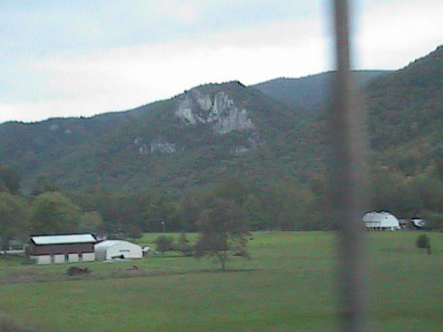
1st snow of the season across the Wv high ground. 4-10″ fell across the Wv mts above 3500 with a few inches down to 3000′. Temps marginal in that lower elevation range. I spent the night of Oct 1, morning of Oct 2nd on Spruce Knob. By morning several inches of snow had accumulated. Going down the east side, snow accumulation on the ground quickly tapered off, but the trees seemed to hold more. Enough so, there were some trees down. Once below 3800′ things were mainly bare. At Canaan the valleys were bare, but light accumulations above 3500′. Through that day, snow levels lowered and picked back up. Temps failed to climb above freezing across some of the high ground the 2nd and 3rd.
Spruce Knob after round 1 of 2 (all these pics Oct 2, 2011)
Canaan Mt bog as seen from Cabin Mt. Temp bottomed out at 37° on the bog, vs upper 40s, low 50s outside of that pocket across the top.
Flow
Surface features and 500mb height anomalies and flow
Pics today
Foliage at present- Anthracnose has took its toll on the typical early changing vibrant maples. From yesterday to today. Things of notice. The high ground across the sods, excluding the reds of the huckleberry/blueberry. Trees are mainly bare or of poor dull color on what remains. The huckleberry/blueberry reds look like a peak in 7-10 days is likely. That said, some are dropping reds, while some half green. Spruce Knob and west,70- 80% bare trees. Riding to Spruce Knob lake, color that was shared on social media a week ago, was basically gone today. This holds true for the areas around the Sinks and along Gandy Creek.
Up to Canaan the lower 2/3rds of Cabin Mt and areas within the valley look like a peak in 10-14 days. This area, for whatever reason looks less affected by anthracnose vs surrounding areas. East side of Canaan Mt looks poor, and on top of Canaan Mt, currently at peak, and not anywhere near as vibrant as typical. Once those maples drop, it will be basically bare. The west side of Canaan Mt, fair amount of color with a peak in 6-10 days.
Backbone Mt and west, some color, lots of green. 2-3 weeks away for good color if it exists.
The holdouts for the best color looks to be portions within Canaan that hold a heavy concentration of birch, and the Blackwater Canyon. The birch look largely unaffected. Peak in 14 days +/-.
North in Garrett. Colors are advancing. Again the typical early changing maples, mostly are bare. Around Deep Creek Lake, which holds a high concentration of oak varieties. Mostly green. Late month when they turn there dull color and oaks are also affected by anthracnose. Marsh Hill has lots of birch, as does Swallow Falls area, expect a peak similiar to Blackwater…
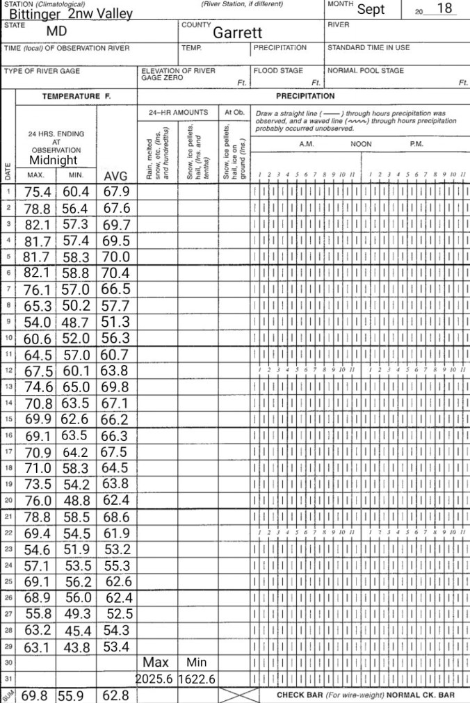
Month Summary
Temps Sept 2018
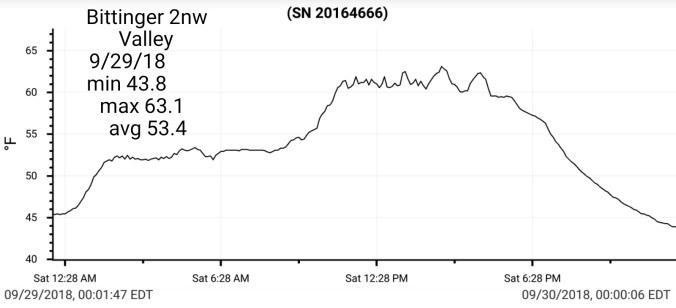
Bittinger 2nw Valley
CRN-Canaan
Precipitation
I finished with 11.2″ at Bittinger 2nw Valley ….elsewhere,
Cloudy start, to a partly cloudy to partly sunny day.
Temp profile this afternoon
Radar-Void of precip
Satellite
Flow
Surface features and 500mb height anomalies and flow
Comparisons
Overall folliage season has come and across Spruce Knob and west, mostly gone for the season. Foliage was brief, not vivid and now lots of bare trees. Anthracnose I suspect played a big role. Any foliage maps that say anything lrss than past peak in this area, simply is not correct. Dolly Sods, the reds of the huckleberries, blueberries. While red-ish, peak is likely a week off. However some peaked in a few patches, and are falling off, some yet are half green. A very abnormal season. The trees across the sods. west of the Allegheny Front. Bare, to dull color, few greens. Again, poor season. Canaan Valley, not a lot of valley color yet, with some dull color and a few bare patches.
East side path atop Spruce Knob 2018-2017
South end of Whispering Spruce Trail viewing west 2018-2017
Cloudy, foggy, dreary start, skies began breaking midday for a blue sun shiny afternoon that has been rare lately. Last night’s rain ended a predawn.
Temp profile this afternoon
Radar with estimates 9pm-9pm
Satellite this afternoon
Flow
Surface features and 500mb height anomalies and flow
On the models
Short term only. Busy and on the go, time limited. Tomorrow looks dry, cool, slightly milder Sunday. Nighttime temps have a outside shot of dipping to the 30s in the coldest valleys.
Comparison
Not a great comparison in foliage, but a comparison vs last year. 1 day early this year. Reds of the blueberry, huckleberry MUCH earlier last year. They were peaking from mid Sept last year through late Sept. Still showing green yet this year.
Cloudy, to rain, rain began earlier in the southern Alleghenies.. Rain, steady to moderate, at times heavy. Fog across wv high ground.
Temp profile this afternoon
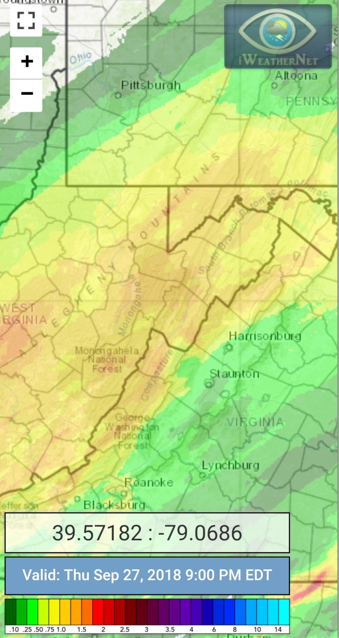
Radar with estimates 9pm-9pm event totals, including the wee hours in to the 28th when the rain halted. Bittinger 2nw Valley 1.7, Garrett College 1.47, Canaan Heights 1.17, CRN 1.68, Cabin Mt at Bald Knob 1.87, Northern Cabin Mt 1.61, Spruce Knob 1.74, Snowshoe 1.61, 7Springs 1.5
Satellite
Flow
Surface features and 500mb height anomalies and flow
On the models..
Short term, heavy rain early tonight, into the predawn hours of Friday, before becoming scattered, and light and shutting off with the clouds breaking some tomorrow. Chilly few days ahead before moderating Sunday. Monitoring a shot at some scattered pockets of 30s Saturday and or Sunday a.m. Be careful out tonight with the flooding occuring.
Cloudy, and a showery day. More so than anticipated. That did cutoff the severe risk.
Temp profile this afternoon
Radar with estimates 9pm-9pm , radar and estimates not doing the best today picking up on all the showers. Picked up .35 at Bittinger 2nw Valley, Garrett College .3, Canaan Heights .3, CRN .22, Cabin Mt at Bald Knob .21, Northern Cabin Mt .28, Spruce Knob .08, Snowshoe .26, 7Springs .28
Satellite
Flow
Surface features and 500mb height anomalies and flow
On the models
Showers and periods of rain look to return tomorrow afternoon and run into Friday morning before becoming more widely scattered and shutting down. Very isolated shot at a pop up Mt shower Saturday.
18z 3km Nam 2m temperatures
18z 3km Nam Simulated Radar
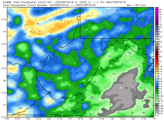
12z ECMWF precip type next 240hrs
12z ECMWF total precip through the next rain tomorrow into early Friday. 12z also including this afternoons rain
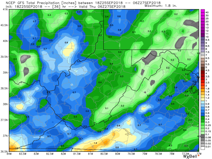
18z GFS precip type next 384hrs
18z GFS total precip through the rain event tomorrow into Friday
Rainy start, rainy morning, a mini break midday, early afternoon, rsin mid afternoon, early evening before quieting down.
Temp profile this afternoon
Radar with estimates 9pm-9pm. At Bittinger 2nw Valley, picked up 1.15 since last evening at 6pm… Garrett College 1.0, Canaan Heights .6, CRN .41, Cabin at Bald Knob .48, Northern Cabin Mt .6, Spruce Knob .18, Snowshoe .19, 7Springs 1.0
Satellite
Flow
Surface features and 500mb height anomalies and flow
On the models….
After a rainy day today, a mini reprieve before eyes go to the cold front tomorrow late afternoon or evening. This may contain some severe weather. Looks like the brunt stays north, but needs watched. Beyond that, a shot at some rsin Thursday night into Friday before “hopefully” a dry weekend for a change.
18z 3km Nam 2m temperatures
18z 3km Nam Simulated Radar
12z ECMWF precip type next 240hrs
12z ECMWF precip through tomorrows cold front(*some of this afternoons rain included in this)
Radar with estimates 9pm-9pm, .15 at Bittinger 2nw Valley…apologies for poor radar image. Normal site is down
Satellite
Flow
Surface features and 500mb height anomalies and flow
On the models….
Showery day tomorrow and milder….then eyes go to a cold front late Wednesday with some storms…
18z 3km Nam 2m temperatures
18z 3km Nam Simulated Radar
Longer range, still no extended dry periods in sight, and the model battle of what happens in the long term remains. As of now, the intrusion of the chill looks weak, and largely gets turned off to the north. That first 10 days of October contains lots of question. Some model runs break the ridge, some do not. Some bring in the seasons first flakes, some runs hold above seasonal temps. Worried(as a cold lover) the ridge has holding power until week 2 Oct. Part of that is the MJO..
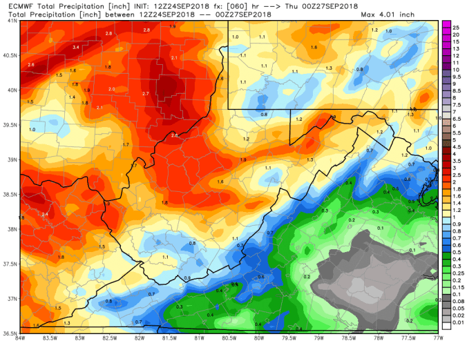
12z ECMWF precip type next 240hrs
12z ECMWF total precip through Wednesdays cold front
18z GFS precip type next 384hrs
18z GFS Total precip through Wednesdays cold front
18z GFS 2m temperatures next 384hrs
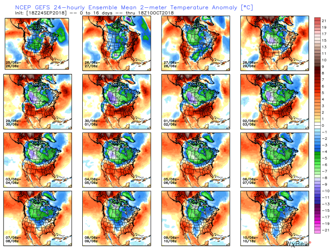
Long range,18z GFS ensembles maintain the ridge in the east through the period. ECMWF is very similiarNow look at that pattern the GEFS holds on to and compare that to MJO correlation that is holding phase 8 and 1
Look at what phase 8 and 1 is correlated to bring. So, that may be a hint, that ridge will fight to hold.
This is not to say a strong front can’t push through during this. A few ECMWF and GFS ensemble members see the cold booting the ridge. A few 12z ECMWF ensemble seeing flakes in early Oct.


 Satellite


 Now look at that pattern the GEFS holds on to and compare that to MJO correlation that is holding phase 8 and 1


